
Content warning
This story may contain sensitive material or discuss topics that some readers may find distressing. Reader discretion is advised. The views and opinions expressed in this story are those of the author and do not necessarily reflect the official policy or position of Vocal.
THE CAPABILITY OF DRONE MAPPING PHOTOGRAPHY
Drone photography for unique views.

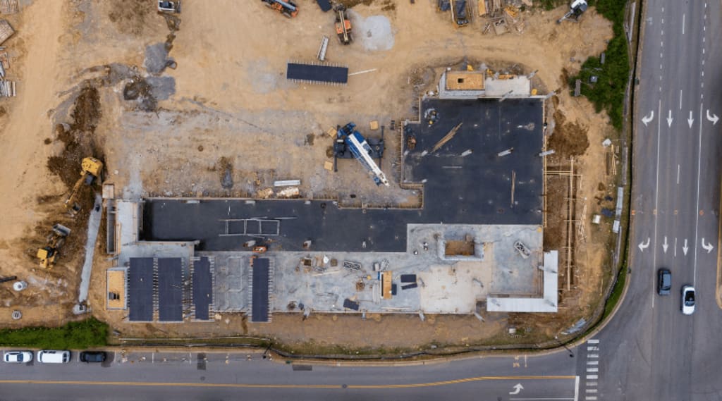
Drone mapping photography is a powerful tool that utilizes unmanned aerial vehicles (UAVs) equipped with cameras to capture high-resolution aerial photos. These photos are then processed using specialized software to create accurate 2D and 3D maps, models, and other outputs. Here are some key capabilities of drone mapping photography:
Photogrammetry:-
Drone mapping primarily uses photogrammetry, which involves capturing multiple overlapping images of an area from different angles. Specialized software then processes these images to triangulate the position of each point, generating a 3D model of the surveyed area.
High Resolution and Accuracy Photos:-
Drones can capture high-resolution photos, providing detailed and accurate representations of the surveyed area. This level of detail surpasses traditional mapping methods, making drone mapping ideal for applications that require precise measurements and visualizations.
Versatility photos from Drone Capture:-
Drone mapping is versatile and can be used in various industries, including real estate photography, aerial photography, photography, and videography. We are professional for photos and video shoots in Sydney.
Cost-Effectiveness:-
Compared to traditional mapping methods, drone mapping is often more cost-effective. Drones are relatively easy to transport and operate, and the data collection process is efficient, reducing the need for extensive fieldwork for photos and video shoots.
Accessibility:-
Drone mapping technology is becoming increasingly accessible, with a wide range of drones and software options available. This accessibility allows for more widespread adoption and application of drone mapping in various sectors.
Detailed Elevation Drone Photography:-
Drone mapping can provide accurate elevation data, even in areas with dense vegetation or difficult terrain. This information is valuable for applications such as flood modeling, forestry management, and infrastructure planning. By leveraging these capabilities, drone mapping photography offers a powerful tool for creating detailed, accurate, and up-to-date maps and models, supporting efficient decision-making and resource management across various industries.
The Value of Arial Drone Photography:-
Aerial drone photography is a game-changer for businesses, offering a unique and captivating way to showcase properties, events, and locations from a fresh perspective. By combining the drone's ability to capture stunning panoramic views with the expertise of a professional, businesses to achieve success. Whether it's real estate, or events, aerial drone photography provides a first-person view that helps potential customers evaluate and connect with a property or location like never before. With the ability to capture high-resolution photos and videos, drones are revolutionizing the way we market and present properties, making them an essential tool for any business looking to stand out and drive results.
Conclusion:-
Aerial drone photography has revolutionized visual storytelling, offering unparalleled perspectives and access to unique vantage points that were once inaccessible. This innovative medium has democratized aerial imaging, making it accessible to enthusiasts and professionals alike, transforming Photography like real estate, surveying, Aerial Photo & Videography, and Construction Drone Services. With the fusion of creativity and technology, drone photography continues to push the boundaries of what is visually possible, providing cost-effective solutions, diverse angles, and precise captures. As technology advances and regulations evolve, the future of drone photography holds limitless potential for innovation, reshaping how we perceive and document the world around us with fresh and captivating viewpoints.
About the Creator
Georgia powley
I am a Georgia, Sydney-based real estate photographer who has been developing a portfolio since 2010 which has included real estate, commercial, corporate, building, and construction photography.
Enjoyed the story? Support the Creator.
Subscribe for free to receive all their stories in your feed. You could also pledge your support or give them a one-off tip, letting them know you appreciate their work.
Keep reading
More stories from Georgia powley and writers in Photography and other communities.
The Moon is Full of Drama
I have been taking pictures of the moon for almost 20 years now. That's a long time in photography years. (What are photography years? That will have to be a whole other article). So the statement I am making is, why is the moon full of drama? I guess my reverse question to you is, how could it not be? Look at the picture above for example, this image screams “I am ready for a night out on the town” It has glitz and glam and all the makings for an evening of fun. I took this image as a few different shots, some out of focus of the stars, and then of the moon, blended to give you a feel of depth. It is a fun little photography trick.
By Nagoh Creative (Greg)26 days ago in Photography
Need a Camera?
Unlock Your Photographic Potential with the Canon EOS Rebel T7 DSLR Camera In an age where smartphones seem to dominate the realm of photography, you might wonder if investing in a dedicated camera is worth it. The Canon EOS Rebel T7 DSLR Camera with its versatile 2 Lens Kit, including the EF18-55mm and EF 75-300mm lenses, makes a compelling case. Here’s why this camera package is an exceptional choice for both budding photographers and seasoned shutterbugs.
By Roosevelt7 days ago in Photography


Comments
There are no comments for this story
Be the first to respond and start the conversation.