


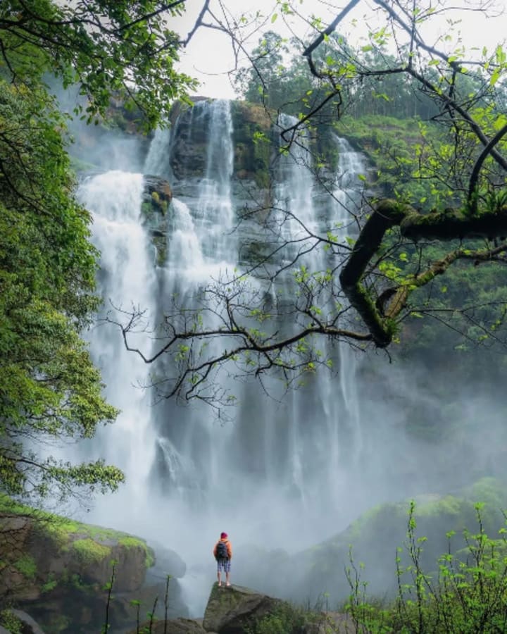
A gorgeous, magnificent waterfall In the Sita Eliya Kandepola forest reserve, which is part of the Uva Paranagama divisional secretariat bordering Nuwara Eliya and Badulla, lies Bomburu Ella (also known as Perawella Fall). It is one of the most well-known tourist attractions on the island. The largest waterfall in Sri Lanka may be found there. The Boburu Ella is both a single waterfall and a group of ten little side-by-side forest waterfalls. They combine to create an astounding spectacle that you will never forget.
The waterfall is 50 meters tall. The waterfall is located at an elevation of 1,500 to 2,000 meters. It is a four-cascade waterfall. Anyone can climb the waterfall with a lot of effort. Additionally, it is a part of the Kotakithul Kanda Mountain (1842m). They are served by the Duulgala River's upper section, which is the main tributary of the Uma River. There is always a beautiful scene created by the water drops. It is an excellent location for photographers. Near the front lawn area, most people almost never forget to snap pictures. In any case, you can descend to the waterfall's base. It's always cold and rainy there.
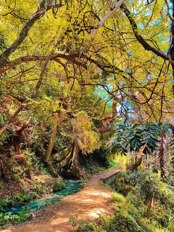
Bomburu Ella is a two-mile roundtrip trek. A hundred to two hundred steps will be climbed at the beginning of the trek. The stairs are located along a huge mountain wall and are difficult to overlook. Numerous signage are there, including a sizable "Bomburu Ella Waterfall" painted on the rock's surface. The clean wind from the mountains revivifies weary spirits and gives them the energy to face the challenges on the road through the forest. The Bomburu Ella is regularly frequented by young, daring tourists, so the locals built little huts selling refreshments where you can relax on a bench and enjoy a hot cup of tea or belimal drink with hakuru on the approach to the waterfall. Alternately, you may stuff your face with hot chili paste and roti. The locals are kind and helpful to visitors, so don't forget to strike up a conversation with them if you ever stop by a hut.
The rice fields and the villagers are both nourished by a little spring that flows down the route leading to the waterfall. Numerous wild creatures and birds now have safe havens because to the waterfall and the lush, green forest's reciprocal connection. One might enter the forest and experience true wildness. Sunny days are the best for visiting the waterfall since they keep the forest route from becoming too soggy and allow visitors to escape the creeping, blood-sucking leeches. The seeker's treasure comes to life when the route through the woodland comes to an end. The lush meadow welcomes the guests by showering milky mist and flows after the torrential torrents that pour from the summits. After a strenuous travel, it is excellent to lie down and have a little nap on the grass spread below the waterfall. It appears to have been specifically designed so that onlookers may admire Mother Nature's elegant works.

Photographers as well as travelers have been drawn to the beauty. The picturesque photos consistently rank among the most popular stories on Facebook and Instagram. Bomburu Ella offers guests from a distance the greatest possible accommodations. However, it is important to remember that in settings like these, when nature is so breathtakingly beautiful, danger might be buried. It is quite dangerous to take selfies on the cliffs' wet, slick edge. Additionally, bathing has the same danger. Numerous tales about young people drowning at the Bomburu Ella are told by the locals. What is underneath the seas has never been found. The villagers claim that there are holes beneath the water that pierce the ground deeply and trap swimmers in the cascade. Sometimes the water level rises suddenly and without any warning, leaving little chance of survival. Never disregard the warnings; staying in a safe area is the best defense against calamities.
History
The origin of the name Bomburu is a subject of legend. According to legend, King Rajasinha II's royal tusker wandered out into the woods once after snapping its chain. The monarch announced that anyone who could manage to capture and tame the tusker would be given a prize because no mahout was able to do it. Finally, a tusker was captured by an elderly man by the name of Wanasinha Mutta, who then tied it to the root of a Bo tree. Because it was a Bo tree root, the villagers initially called the settlement Bo-mule, which subsequently became Bombure.
Best time to visit
Although Nuwara Eliya has rain all year round, the driest period is from January to March. Because it will be warm and dry throughout these months, Bomburu Ella is a fantastic place to visit. But if you go during the rainy season, especially around November and December, the waterfall will be at its most intense and potent! In case it rains or you are caught in it, it is recommended to have a raincoat!

How to get to Bomburu Ella
The area is often regarded as the boundary between the Nuwara Eliya and Badulla districts. The location is around 21 kilometers from Welimada and 19 kilometers from Nuwara Eliya away. If you're coming from Colombo, you can use Bandarawela to go to Welimada Town. From there, buses for public transportation are accessible. The Bomburu Ella Waterfall is the nearest settlement to Perawella. Take the Welimada Pusselawa road, exit at Ambagasdova Junction, and then take the Perawella Bus Route to go to Bomburu Waterfall.
The road is in decent shape up until the point when the climb to the waterfall begins. There are parking places accessible for your cars. It will take two to three kilometers through the forest, with some hiking and climbing, to get to the foot of the waterfall. It is not too difficult, and the breathtaking scenery and cooler temperature will prevent you from becoming fatigued. Once you get to the top, you may relax, take pictures, and take as many baths as you like in the area's natural pools.
Places to visit near Bomburu Ella
- Chariot Path
The grassland (Plain) known as King Rawana's Chariot Path resembles a route. It is located next to Frotoft Tea Estate in Pussallawa in the Kandy district of the Central Province of Sri Lanka on top of a mountain range encircled by a pygmy forest.
A plain meadow on top of a mountain range that is encircled by a pigmy forest serves as King Ravana's chariot road. According to the legends, this route was first constructed so that King Ravana could utilize his flying chariot, the "Dandu Monaraya," to travel over his realm. According to legends from long ago, he traveled this route to exhibit Queen Seetha of India the splendor, grace, and elegance of his country as well as Sri Lanka.
Read : https://zeloan.blogspot.com/2022/09/ChariotPath%20.html
- Haputale
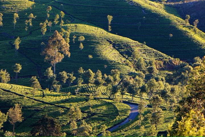
Haputale, which is located in the Badulla District of the Uva Province at a height of 1431 meters above sea level, is part of that region. One of the three main tea-producing regions in Sri Lanka is called Uva, and it stretches from Haputale to Badulla. Haputale is flanked by hills covered in cloud forests and slopes covered with tea plantations. Train travel is one method to explore this region. On the route from Kandy or Nanu Oya (Nuwara Eliya) to Ella or Badulla, there is a train station called Haputale. The Colombo-Badulla route (A16 highway from Beragala to Hali Ela) passes via the Haputale pass, from which a side road leads to Nuwara Eliya.
Read : https://zeloan.blogspot.com/2022/09/haputale-in-sri-lanka.html
- Idalgashinna
Idalgashinna is a little hamlet in Sri Lanka's Uva Province's Badulla District. It is situated in the Haputale-Namunukula mountain range at a height of approximately 1,615 meters (5,299 feet) above sea level. The Idalgashinna Estate is located in this region, and the closest significant town is Haputale, which is located approximately 9 kilometers south on the railway. The Thangamale Bird Sanctuary is situated between these two locations. The Welimada Divisional Secretariat oversees education in the region and is responsible for Idalgashinna Tamil Vidyalaya (Idalgashinna Tamil College), Beauvais Tamil Vidyalaya, and Ellethota Vidyalaya.
Read : https://zeloan.blogspot.com/2022/08/idalgashinna-in-sri-lanka.html

- Horton Plains
In 1988, Horton Plains National Park was established as a national park in Sri Lanka's central highlands. At an elevation of 2,100-2,300 m (6,900-7,500 ft), it has cloud forest as well as montane grassland. It has a diverse animal and plant population, and many of the species are local endemics. It is located 8 kilometers (5.0 mi) from Ohiya, 6 kilometers (3.7 km) from the renowned Ohiya Gap/Dondra Watch, and 32 kilometers (20 mi) from Nuwara Eliya. It is also a well-liked tourist site.
Read : https://zeloan.blogspot.com/2022/07/horton-plains-in-sri-lanka.html
- Hakgala Botanical Garden
The second-largest of Sri Lanka's five botanical gardens, Hakgala Botanical Garden is next to the Hakgala Strict Nature Reserve, which is home to a variety of wild animals, including bears, monkeys, and birds. The route to Hakgala via the Badulla road is a lovely downhill drive, largely through pine trees, and is located around 5 kilometers south of Nuwara Eliya. A veritable paradise is created by the diverse flora and wildlife, which are complemented by the pleasant cool weather that lasts the entire year. It features a huge variety of plant life.

- Moon Plains
Till the late 1990s, the valley known as Moon Plains, which is 400 meters long and 30 to 40 meters deep, was a catchment area. When you visit this place, the surroundings are so stunning that you may feel as though you are in another country.
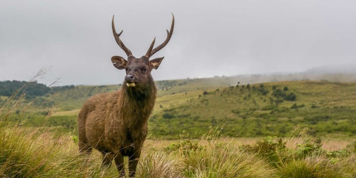
This Agricultural and Environment zone, which was established in March 2014, is situated in Nuwara Eliya. With the blue hills in the background, this lovely region of land is rendered even more gorgeous by its flat, slightly sloppy land mass. The lush plains are home to numerous rare bird species as well as wild deer, elk, and buffalo that are seen feeding there. Moon Plains, a miniature version of World's End, offers a 3560-degree panorama of the peaks and towers in the area from its edge. One could spot one or two leopards if they're lucky.

It is our duty to treat nature better when it treats us well. Never leave a trace in the trials that could compromise its purity. Since the forest has long been a haven for many wild creatures and should continue to remain so, refrain from discarding even a single piece of polythene there. The lovers of nature will always have memories of Bomburu Ella in their hearts. Those who value beauty would never tire of viewing the cascades.
Google Map:
About the Creator
Zeloan
I'm a Traveller, Blogger, and Content Creator. Visit Sri Lanka, and you can see the most beautiful places in the world and the remarkable hospitality here


Comments
There are no comments for this story
Be the first to respond and start the conversation.