
Under a huge metropolis, a massive secret water resource was found.
The location of the water reserve

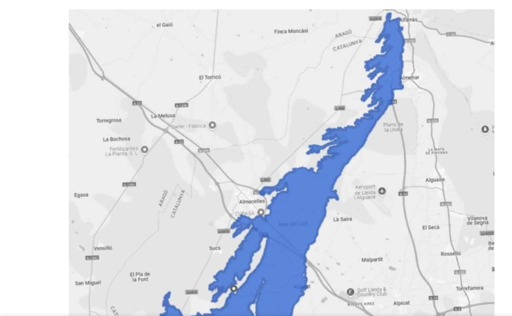
A huge subterranean water reserve covering 31 square miles beneath farmland in northeastern Spain has been discovered by scientists. The discovery challenges preconceived notions about how to use and safeguard the area's subsurface water.
What the maps display
Planas de Raimat-Monreal is the name of the draft maps for the Ebro Basin's 2028–2033 planning cycle, which outline the entire scope of this recently established water reserve. Planners at the Ebro River Basin Authority (CHE) formally included the aquifer in the basin's groundwater inventory and recorded its size.
At its widest point, the reserve is less than six miles wide and extends about 19 miles from north to south. As a result, the subterranean water reservoir has a long, tapering shape. The existence of a sizable but still poorly understood system is established by that stated footprint, necessitating further investigation in the future.
The location of the water reserve
According to early accounts, the reserve is located in the Segrià region of northeastern Spain, beneath fields outside the city of Lleida. Several adjacent agricultural tracts are covered by the subterranean "sea."
The majority of the reserve is located beneath heavily farmed terrain, with a small number of agricultural districts accounting for the majority of the reserve. Beneath cropland that never appeared very moist, a significant reserve remained undetected, which can be explained by its narrow shape.
The way the river flows
A portion of the reserve is drained back out by springs and canals, while rain and agricultural water supply it from above. The primary inputs, according to the draft notes, are irrigation water that seeps back and rainwater that moves through the soil.
Water then travels outward via neighbouring river channels and peripheral springs, with the neighbouring Clamour Amarga stream serving as a collector. Any significant alteration at the surface can proceed downhill through the system since movement is dependent on slope, sediments, and drainage.
Why the water reservoir was kept a secret
Planas de Raimat-Monreal is one of the new zones listed in Spain's groundwater plan that require initial or additional characterisation before officials may manage them. The draft notes clearly state, "There is not enough information to develop an action plan."
Instead of treating the reserve as an updated version of an earlier mapped unit, national planning materials treat it as a new addition. This stage indicates that the reserve's name came first, but comprehension of its operation still needs to catch up.
What the old rivers left behind
Ancient river systems left behind layers of gravel deposits, river terraces, and floodplain sediments that can be seen in regional geology. These deposits are important because tighter layers impede and reroute water flow, while porous gravel and sand can trap it.
The region formerly carried far more moving water, as evidenced by the numerous shifting channels preserved in the same geologic record. When viewed in this light, the recently mapped reserve is the hidden residue of an earlier landscape rather than a mysterious nook.
How land was altered by irrigation
The Aragon and Catalonia Canal, which stretches for several of miles, irrigates a sizable portion of farmland before reintroducing water into the nearby river system. Because some irrigation water returns to the ground rather than remaining in crops, that contemporary water network altered the surface.
Since a large portion of this land remained dry steppe long before canals were built, irrigation probably changed both farming The reserve reflects both ancient geology and water engineering from the previous century, which makes the story more complicated when viewed up close.
A separate water reserve
Planners cannot overlook the fact that the reserve has no lateral contact with nearby subterranean bodies and is referred to as independent in preliminary descriptions. Because there are fewer side connections, there are less concealed ways for water to flow, which makes isolation useful for tracking inputs and losses.
Because local pollutants may remain localised rather than spreading throughout a wider network, the same independence also raises the stakes. Because of this, a reserve may appear attractive on paper but turn out to be brittle once monitoring starts.
What the dangers entail
Even before complete characterisation starts, the same draft notes already state that industrial and urban discharges put pressure on the reserve. Eight percent of the volume is subject to lower intensity pressures, while 91.9 percent of the volume is affected at moderate intensity.
Such figures explain why planners are reluctant to treat the find as additional security, but they do not prove damage. The reserve is still a potential rather than a reliable precaution until sampling and long-term tracking fill up the gaps.
What follows
Before anyone can create meaningful management strategies, chemistry, flow direction, storage, and vulnerability must be determined. New wells, repeated measurements, and models that examine how pumping or drought will alter levels are probably going to be part of that endeavour.
While poor responses could encourage overuse before the area even realises it, good responses could safeguard a priceless asset. Admitting how much is still unknown underground is currently the most difficult aspect of a terrain that appeared to be thoroughly understood.
A more subdued alert
Planners have discovered a hidden system with history, promise, and limitations beneath a heavily farmed farming sector rather than an assured source. Slow measurement, cautious protection, and the self-control to treat concealed water as limited will determine what happens next.
About the Creator
Enjoyed the story? Support the Creator.
Subscribe for free to receive all their stories in your feed.
Comments
There are no comments for this story
Be the first to respond and start the conversation.