Ancient
The King of All Nuclear Bombs: The Story of the Tsar Bomba . AI-Generated.
The King of All Nuclear Bombs: The Story of the Tsar Bomba Nuclear weapons represent the best annihilative force altruism has anytime created, and amid them, one bomb stands out as the better and best able anytime detonated: the Tsar Bomba. Tested by the Soviet Union during the Cold War, this bomb’s aberrant adeptness becoming it the appellation "King of Bombs," and it charcoal a air-conditioned admonition of the abeyant for confusion that nuclear weapons hold.
By Say the truth 2 years ago in History
How Did Hitler Rise to Power?
The rise of Adolf Hitler, a dictator responsible for one of the most horrific genocides in history, is a chilling narrative that began in the aftermath of World War I. Germany had fought valiantly, but the successful advance of the Allied forces in1918 made it clear that the war was unwinnable. Consequently, Germany signed an armistice, bringing an end to the fighting. As Germany’s imperial government crumbled, civil unrest and widespread worker strikes erupted throughout the nation.
By DANIEL AKAM OKO2 years ago in History
Bradford-on-Avon Tithe Barn: A Medieval Masterpiece
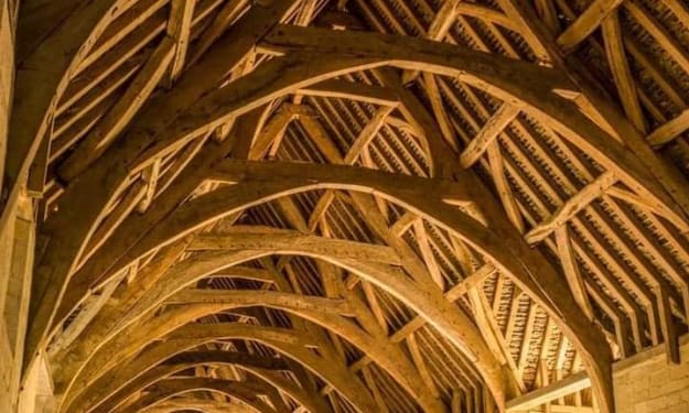
Nestled in the picturesque Wiltshire countryside, the Bradford-on-Avon Tithe Barn stands as one of the most impressive examples of medieval architecture in England. Built in the mid-14th century, this remarkable structure is not only one of the largest medieval barns in the country but also one of the finest in terms of its design and craftsmanship. Serving as a reminder of the agricultural and ecclesiastical history of the region, the Tithe Barn was originally constructed to support Barton Grange, a manor farm that belonged to the powerful Shaftesbury Abbey in Dorset. With its towering stone walls and majestic timber roof, the Bradford-on-Avon Tithe Barn offers visitors a glimpse into England’s rural past. In this post, we’ll explore the history, architecture, and significance of this medieval barn, as well as its enduring legacy. The Origins of the Tithe Barn The Tithe Barn at Bradford-on-Avon was built during the mid-14th century, a time when the rural economy of England was heavily intertwined with the power and wealth of the Church. Shaftesbury Abbey, which owned Barton Grange and its lands, was the wealthiest nunnery in medieval England. As part of the Benedictine order, the nuns of Shaftesbury oversaw vast agricultural estates that supplied the abbey with food, income, and resources. The barn was constructed to store the "tithes" that were collected from the local farming community. Under the system of tithing, farmers were required to give a portion of their produce—usually one-tenth—to the Church. These tithes could include grains, livestock, wool, and other agricultural products. The barn, therefore, played a crucial role in housing the goods that sustained the abbey’s wealth and ensured its continued operation. After the dissolution of the monasteries under Henry VIII in 1539, Shaftesbury Abbey was suppressed, and its lands, including Barton Grange, passed into private hands. The Tithe Barn continued to be used for agricultural purposes for several centuries, remaining part of a working farm until 1914. The Architecture of the Barn The Bradford-on-Avon Tithe Barn is an architectural marvel, both in its scale and in the quality of its construction. Measuring over 168 feet in length and 33 feet in width, the barn is truly vast, with enough space to store substantial quantities of produce. Its design, like many medieval barns, is functional but also reflects the grandeur typical of ecclesiastical buildings of the time. The exterior walls are constructed from limestone rubble, a common building material in the area. The thick stone walls not only provided support for the massive roof structure but also helped to protect the stored produce from the elements. The barn’s roof, made of wooden timbers, is one of its most striking features. The steeply pitched roof is supported by a series of large, intricately designed oak trusses, which are arranged in an A-frame shape. These trusses, some of which are more than 30 feet in height, demonstrate the skill and craftsmanship of medieval carpenters. Each timber was hand-cut and fitted together using traditional joinery techniques, creating a roof structure that has withstood the test of time. One of the most impressive aspects of the barn’s architecture is the way in which form and function are perfectly balanced. The barn’s size was necessary to accommodate large quantities of agricultural produce, but the design also ensured that the interior was well-ventilated and dry. The large doorways at either end of the barn, along with smaller ventilation slits in the walls, allowed air to circulate freely, preventing dampness and rot. The barn also features a number of original stone buttresses, which were added to support the weight of the massive roof. These buttresses, along with the barn’s sturdy stone walls, give the structure a sense of permanence and strength, qualities that were undoubtedly important for a building intended to store valuable resources. The Significance of Shaftesbury Abbey Shaftesbury Abbey, which owned Barton Grange and the Tithe Barn, was one of the most powerful and wealthy religious institutions in medieval England. Founded in the late 9th century by King Alfred the Great, the abbey was initially established as a royal nunnery. Over the centuries, it grew in size and influence, amassing vast estates across southern England. The abbey was particularly known for its production of wool, which was one of the most important industries in medieval England. The wool produced on the abbey’s estates was highly prized, and much of it was exported to continental Europe, where it was used to make fine textiles. The income generated from wool sales helped to finance the abbey’s lavish building projects, including the construction of barns like the one at Bradford-on-Avon. While Shaftesbury Abbey was dissolved in 1539 as part of Henry VIII’s dissolution of the monasteries, its legacy lives on in the many buildings and estates it once controlled. The Bradford-on-Avon Tithe Barn is one of the few remaining structures that offer a direct connection to this important chapter in English history. The Barn’s Journey Through the Centuries After the dissolution of Shaftesbury Abbey, the Bradford-on-Avon Tithe Barn continued to serve as an agricultural building for several centuries. By the late 19th and early 20th centuries, however, changes in farming practices and the industrialization of agriculture meant that large tithe barns like the one at Bradford-on-Avon were no longer as essential as they had once been. In 1914, the barn ceased to function as part of a working farm and fell into a period of neglect. Fortunately, in the years that followed, efforts were made to preserve the barn and protect it from further decay. The barn was eventually restored and opened to the public, allowing visitors to appreciate its historical significance and architectural beauty. Today, the Bradford-on-Avon Tithe Barn is managed by the English Heritage organization and stands as a popular tourist attraction. It remains one of the finest examples of medieval agricultural architecture in England, drawing visitors from around the world who come to marvel at its grandeur and learn about its rich history. A Living Monument The Bradford-on-Avon Tithe Barn is more than just a relic of the past—it is a living monument that continues to inspire awe and admiration. Its sheer size and remarkable craftsmanship offer a window into a time when agriculture was the backbone of the economy, and the Church wielded immense power. While much has changed in the centuries since the barn was built, its enduring presence on the landscape serves as a reminder of the skill and dedication of the people who constructed it. Whether you’re a history enthusiast, an architecture lover, or simply someone who appreciates beautiful places, the Bradford-on-Avon Tithe Barn is a must-see destination. As you walk through its vast, echoing interior and gaze up at the intricate wooden beams overhead, you can’t help but feel a connection to the generations of people who have walked the same path, marveling at the same structure, for more than 600 years.
By Deji Akomolafe2 years ago in History
The Sweet Track: A 5,830-Year-Old Window into Neolithic Ingenuity
Tucked away in the marshy Somerset Levels of southwest England lies one of the most remarkable archaeological discoveries of the 20th century: the Sweet Track. This ancient Neolithic timber walkway, unearthed in 1970, is not only a marvel of prehistoric engineering but also one of the oldest known wooden trackways in the world. Dating back an astonishing 5,830 years, the Sweet Track offers a glimpse into a time when humans were transitioning from nomadic lifestyles to more settled agricultural communities. It stands as a testament to the ingenuity and resourcefulness of our distant ancestors. The Discovery and Significance of the Sweet Track The Sweet Track was discovered by chance in 1970 during peat excavations in the Somerset Levels, a low-lying area known for its wetlands and bogs. Local archaeologist Ray Sweet, after whom the track is named, realized the significance of the timbers that had been exposed by the digging. Subsequent investigations revealed that these wooden planks and poles formed a long, continuous pathway stretching across the boggy landscape. Radiocarbon dating confirmed the remarkable age of the Sweet Track, pinpointing its construction to around 3807-3806 BC. This places the track in the Neolithic period, a time when the first farmers were cultivating crops and raising livestock in Britain. The discovery of the Sweet Track not only provided new insights into the technological abilities of Neolithic societies but also gave archaeologists a unique opportunity to study well-preserved organic material from this era, something rarely found in archaeological sites. A Dry Path Through the Wetlands The Somerset Levels, then as now, were a marshy, waterlogged landscape. For the Neolithic people living in the area, this made travel across the wetlands difficult and dangerous, especially during periods of heavy rain or flooding. The Sweet Track was part of a broader network of timber walkways built to provide a dry and stable path over the marshes, connecting settlements and facilitating movement across the landscape. The track itself was constructed using timber planks laid across wooden poles that had been driven into the soft ground. The builders used a variety of tree species, including oak, ash, lime, and hazel, to create a sturdy structure that could support the weight of people walking across the wetland. The craftsmanship involved in its construction is impressive, especially considering that Neolithic people lacked metal tools. Instead, they relied on stone axes to fell trees and shape the timbers. The Sweet Track extended for around 2 kilometers (1.2 miles), making it one of the longest known prehistoric timber trackways. Its careful construction and alignment suggest that the Neolithic builders had a good understanding of both the landscape and the materials they were working with, and they likely possessed significant knowledge of carpentry and engineering. Life in Neolithic Somerset The people who built and used the Sweet Track lived during a period of significant change in human history. The Neolithic, or New Stone Age, marked the transition from a hunter-gatherer lifestyle to one based on agriculture and permanent settlements. In Somerset, this shift would have been particularly challenging due to the region’s waterlogged environment, but the construction of trackways like the Sweet Track demonstrates that these early farmers were adapting to their surroundings in creative and innovative ways. Excavations around the track have uncovered a wealth of artifacts that provide clues about the daily lives of the people who used it. These finds include flint tools, pottery shards, wooden containers, and even plant remains, offering a snapshot of the types of resources and materials that were available to Neolithic communities in the Somerset Levels. The discovery of human footprints preserved in the peat near the track adds a poignant reminder of the individuals who once walked this ancient path. Interestingly, the Sweet Track was built directly on top of an earlier trackway, known as the Post Track, which suggests that the area had been an important route for some time. This raises intriguing questions about the role of these trackways in Neolithic society—were they purely functional, or did they hold some symbolic or ceremonial significance as well? Preservation in the Peat One of the reasons the Sweet Track has survived for nearly six millennia is the unique environment of the Somerset Levels. The waterlogged conditions of the peat bogs create an oxygen-poor environment that prevents the decay of organic materials like wood. As a result, the wooden timbers of the Sweet Track were exceptionally well-preserved when they were discovered, allowing archaeologists to study them in detail. Peat extraction, however, poses a significant threat to the preservation of the trackway. As the peat is removed and the water table drops, the once-protected timbers are exposed to air, causing them to dry out and decay rapidly. Efforts have been made to conserve sections of the Sweet Track, but much of it has already been lost to natural decay and human activity. The Legacy of the Sweet Track The discovery of the Sweet Track has provided invaluable insights into Neolithic technology, society, and the relationship between humans and their environment. It serves as a reminder of the ingenuity of our ancestors, who were able to overcome the challenges of their environment using the materials and tools available to them. Today, the Sweet Track is recognized as a significant piece of cultural heritage, not only for the people of Somerset but for the world. It stands as one of the earliest examples of large-scale human engineering and a testament to the resourcefulness of Neolithic societies. Though much of the trackway may now be hidden beneath the ground, its legacy endures, offering us a tangible connection to a distant past and a deeper understanding of the lives of the people who once walked its ancient planks.
By Deji Akomolafe2 years ago in History
The Pantheon: Rome’s Ancient Marvel and the World’s Greatest Concrete Flex
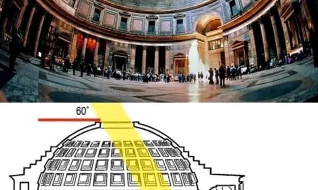
If there’s one building that can boast over 1,900 years of architectural dominance, it’s the Pantheon in Rome. Not only is this awe-inspiring structure a breathtaking piece of ancient history, but it also holds the remarkable title of having the World’s Largest Unreinforced Concrete Dome—a record it’s been flaunting for nearly two millennia. That’s right, for almost 2,000 years, architects have been trying to top what the Pantheon accomplished in the 2nd century, and let’s just say, it’s a pretty tough act to follow. The Pantheon’s dome is like the ultimate architectural mic drop, challenging modern builders with a silent, "Top that, future people!" The Pantheon’s Dome: A Feat of Engineering Genius Completed around 125 AD during the reign of Emperor Hadrian, the Pantheon’s dome is a marvel of ancient engineering. At a massive 43.3 meters (142 feet) in diameter, it remains the largest unreinforced concrete dome in the world. Think about that for a second: the structure has been standing tall for almost two millennia without any modern reinforcements like steel beams or advanced support structures. And it’s still perfectly intact. The secret to this incredible feat lies in the ancient Romans' genius use of materials and design. The concrete mixture they used varied in density, with heavier materials at the bottom and lighter ones at the top. The Romans also incorporated volcanic ash into the concrete mix, giving it incredible strength while keeping it lightweight—an ancient precursor to today’s high-tech concrete innovations. At the top of the dome, the concrete is significantly thinner, reducing the overall weight while maintaining structural integrity. To top it off, the dome's interior is coffered, meaning it's adorned with recessed panels that reduce the overall weight of the structure while also adding to its aesthetic grandeur. This design not only showcases the architectural mastery of the ancient Romans but also highlights their sense of style and elegance. The Oculus: The Pantheon’s Eye to the Sky At the very center of this massive dome is the oculus, an open circular hole that measures 9 meters (30 feet) in diameter. This "eye" at the top of the Pantheon has no glass or covering, leaving the interior of the Pantheon open to the elements. While that might sound like a design flaw, it’s actually one of the building’s most impressive features. The oculus serves several important purposes. First, it allows natural light to flood the interior, creating a beautifully illuminated space that changes throughout the day. The light filtering in through the oculus moves across the floor like a giant sundial, marking the passage of time in a spectacularly visual way. Second, it reduces the weight at the top of the dome, which is crucial for maintaining the structure’s balance and stability. But the oculus isn’t just practical; it’s also part of the Pantheon’s grand celebration of the heavens. The name "Pantheon" comes from the Greek words "pan" (all) and "theon" (gods), suggesting the temple was dedicated to all the gods of ancient Rome. The oculus, then, is like a celestial portal, connecting the earth to the divine realm above. When standing inside the Pantheon and looking up at the oculus, it’s hard not to feel a sense of wonder and awe as the sky appears to open up to you. The Pantheon’s Party Trick: Rome’s Birthday Solar Show As if the Pantheon wasn’t already impressive enough, it also throws a solar-powered party every year on April 21st, Rome’s official birthday. On this day, the sun aligns perfectly with the oculus and shines a beam of light directly through the Pantheon’s front door. It’s as if the building itself is celebrating the birth of the Eternal City. This phenomenon wasn’t an accident; the alignment was intentionally designed by the architects to honor Rome. During ancient times, this dramatic sunlight display would have been a significant event, with the emperor standing in the doorway, illuminated by the celestial beam as a symbol of divine favor and the city’s enduring power. Today, this annual solar spectacle is still celebrated, drawing crowds of visitors eager to witness the Pantheon’s timeless connection to the cosmos. A Masterpiece that Defies Time In an age where modern skyscrapers rise and fall, the Pantheon stands as a reminder of the brilliance of ancient Roman engineering and architecture. Its dome, a testament to human ingenuity, remains unbeaten as the largest unreinforced concrete structure ever built. With its awe-inspiring design and perfect alignment with the cosmos, the Pantheon continues to captivate visitors from around the world, offering a glimpse into the greatness of ancient Rome. As you step inside the Pantheon and gaze up at the oculus, you’re not just looking at a roof—you’re looking at history. You’re standing where emperors once stood, bathed in the same sunlight that has illuminated this sacred space for nearly 2,000 years. And while many have tried to outdo this architectural wonder, the Pantheon simply looks down from its lofty height, as if to say, "Top that." So, next time you find yourself in Rome, remember to pay a visit to this ancient masterpiece. Whether it’s a sunny afternoon or Rome’s birthday, the Pantheon is always ready to show off its timeless charm—no RSVP needed.
By Deji Akomolafe2 years ago in History
The Fosse Way and the A303: Unearthing England’s Ancient Roman Road
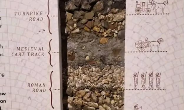
In the English countryside, beneath the busy modern lanes of the A303 highway, lies a hidden historical treasure—an ancient Roman road known as the Fosse Way. This road, which has existed for nearly two millennia, traces a route that once connected the southwest of England to the heart of Roman Britain. Though buried beneath layers of modern infrastructure, cross-sections of the ground beneath the A303 reveal the path of this remarkable Roman road, providing a glimpse into a world that existed thousands of years ago. The Fosse Way is not just a relic of the Roman occupation; it is a testament to the enduring significance of this route, which has remained a central artery of human activity since long before the Roman Empire laid its first stone. The proximity of this road to Stonehenge, one of the most famous prehistoric monuments in the world, highlights the historical depth of the area, where human activity has spanned from the Iron Age and possibly even earlier. In this blog post, we will explore the historical importance of the Fosse Way, its connection to the Roman Empire, and how its path intersects with some of England’s most iconic ancient landmarks, such as Stonehenge. We will also consider how this ancient route continues to influence modern infrastructure and the cultural landscape of England today. The Fosse Way: A Roman Legacy The Fosse Way was one of the principal Roman roads built in Britain following the Roman invasion in AD 43. The word “Fosse” comes from the Latin fossa, meaning ditch, as it is believed the road may have originally been flanked by defensive ditches. Stretching from Exeter (Isca Dumnoniorum) in the southwest to Lincoln (Lindum Colonia) in the northeast, the Fosse Way spanned nearly 200 miles and served as a crucial military and trade route for the Romans. This road was part of a larger network of Roman roads that crisscrossed Britain, facilitating the movement of troops, goods, and information across the occupied territory. Roman engineers, renowned for their road-building prowess, constructed the Fosse Way to be as straight as possible, adhering to a direct route that cut across the varied landscape of southern and central England. The Fosse Way’s straightness is one of its most striking features, even today. Unlike modern roads, which often follow the contours of the land, Roman roads were built with military efficiency in mind. The Romans were less concerned with the challenges posed by the terrain and more focused on creating the shortest and fastest route between two points. This meant cutting through hills, building bridges over rivers, and laying down a solid foundation of stone, gravel, and sand to ensure durability. A Road Through History The significance of the Fosse Way extends far beyond its function as a Roman road. The route it follows was likely in use long before the Romans arrived, serving as a pathway for ancient Britons during the Iron Age. The road passes through or near several key historical sites, including Stonehenge, the famous prehistoric stone circle that dates back over 4,000 years. The proximity of the Fosse Way to Stonehenge suggests that this area has been a hub of human activity for millennia. Stonehenge itself, with its mysterious origins and alignment with the solstices, was a place of ceremonial and astronomical significance for the ancient peoples of Britain. The surrounding landscape is dotted with burial mounds, earthworks, and other archaeological remnants of early societies, further underscoring the importance of this region as a crossroads of human history. By the time the Romans arrived in Britain in the 1st century AD, they encountered a land already rich in culture and history. The Fosse Way allowed the Romans to establish a firm foothold in this new territory, but it also connected them with the ancient traditions and landmarks of the British Isles. As the Romans built their cities, forts, and roads, they layered their own history over that of the ancient Britons, creating a complex tapestry of human civilization that remains visible today. The Fosse Way and Stonehenge: A Unique Intersection One of the most fascinating aspects of the Fosse Way is its proximity to Stonehenge. While the Roman road does not pass directly through the monument, it runs close enough to provide a tantalizing connection between these two significant historical sites. Stonehenge, a UNESCO World Heritage site, is one of the most iconic prehistoric structures in the world, and its location near the Fosse Way raises interesting questions about the relationship between these two landmarks. Did the Romans know about Stonehenge? While there is no definitive evidence that the Romans paid special attention to Stonehenge, it is highly likely that they were aware of its existence. Stonehenge would have already been an ancient monument by the time the Romans arrived, and given their appreciation for monumental architecture, they may have seen it as a curiosity, if not a place of religious or cultural significance. It is also possible that the Fosse Way itself was aligned with older, prehistoric tracks that had been in use for centuries. The road’s straightness and its alignment with key natural and man-made landmarks suggest that the Romans may have been following routes established long before their arrival. In this way, the Fosse Way serves as a bridge between the prehistoric past and the Roman period, linking two of the most significant epochs in British history. The A303: A Modern Highway With Ancient Roots Today, the A303 highway runs roughly parallel to the route of the Fosse Way, with parts of the modern road built directly over the ancient Roman road. The A303 is a major thoroughfare connecting the southwest of England to London, and it remains one of the most heavily trafficked roads in the region. However, beneath the asphalt and concrete, the legacy of the Fosse Way endures. The modern road system owes much to the Roman road network, which laid the groundwork for the development of infrastructure in Britain and across Europe. Roman roads were so well-built that many of them continued to be used for centuries after the fall of the Roman Empire, and their influence can still be seen in the layout of modern roads and highways. The A303 is a prime example of this enduring legacy. In places where the modern road deviates from the path of the Fosse Way, archaeologists have found cross-sections of the ancient Roman road beneath the surface, revealing the stone foundations that have remained intact for nearly 2,000 years. These discoveries provide a tangible link between the past and the present, reminding us that even as we travel along modern roads, we are often following in the footsteps of those who came before us. Conclusion: The Fosse Way’s Enduring Legacy The Fosse Way is more than just an ancient Roman road—it is a pathway through history, connecting the modern world with the ancient past. From its role as a critical Roman military route to its connection with prehistoric landmarks like Stonehenge, the Fosse Way has been at the center of human activity in Britain for thousands of years. Today, as drivers travel along the A303, they are unknowingly following the route of the Fosse Way, retracing the steps of Roman soldiers, traders, and travelers who once walked this road. Beneath the modern highway lies the hidden story of an ancient civilization, preserved in the layers of earth that have accumulated over centuries. The Fosse Way’s enduring presence beneath the A303 serves as a reminder of the deep and complex history that lies beneath the surface of the land we live on. It is a testament to the skill and foresight of the Roman engineers who built it, as well as to the countless generations of people who have traveled along this route, leaving their own marks on the landscape of Britain.
By Deji Akomolafe2 years ago in History
The White Horse of Uffington: A 3,000-Year-Old Enigma
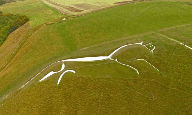
Perched on the rolling chalk hills of Oxfordshire, England, the White Horse of Uffington has captured the imagination of locals and historians alike for over 3,000 years. This iconic hill figure, carved into the earth, stands as a remarkable testament to the creativity and ingenuity of prehistoric peoples. Yet, for all its grandeur and historical significance, much about the White Horse remains shrouded in mystery. Who created it? Why was it made? And what does it truly represent? In this blog post, we’ll explore the fascinating history of the White Horse of Uffington, delve into its possible meanings, and examine why this ancient symbol continues to captivate us today. A Monument to Time: The Creation of the White Horse The White Horse of Uffington is a striking figure that measures approximately 360 feet in length. It was created by carving deep trenches into the chalk hillside and then filling them with crushed white chalk, which forms the sleek, almost abstract image of a horse. This process has left an enduring mark on the landscape that can be seen for miles around, its brilliant white outline standing out vividly against the surrounding greenery. Dating the White Horse has been a matter of some debate among archaeologists. For years, it was assumed that the figure might be a relatively recent creation, perhaps from the Saxon or medieval periods. However, scientific dating techniques have now shown that the figure dates back to at least 1000 BC, placing it firmly in the late Bronze Age or early Iron Age. This makes the White Horse of Uffington one of the oldest hill figures in Britain. What’s more remarkable is that the figure has been maintained continuously for over 3,000 years. Generations of locals have taken it upon themselves to "scour" the horse, a process involving cleaning and refilling the trenches with fresh chalk to ensure that the figure remains visible. This tradition, which continues to this day, speaks to the enduring cultural significance of the White Horse to the people of Oxfordshire. The Mystery of Its Meaning Despite its age and prominence, the true purpose and meaning of the White Horse of Uffington remain largely speculative. The figure is so stylized that it doesn’t resemble a horse in a traditional sense; its long, flowing curves and elongated body give it an almost ethereal, abstract quality. This has led some researchers to suggest that it may not represent a horse at all, but perhaps a dragon or another mythical creature. Others argue that it is indeed a horse, given that horses held significant symbolic and practical importance in prehistoric Britain. One prevailing theory is that the White Horse was a symbol of power and fertility, perhaps connected to a local deity or tribal chief. Horses were associated with the elite in Bronze Age society, and their strength and speed made them valuable both in warfare and in agriculture. The figure may have been a sacred symbol, intended to assert dominance over the land and invoke protection from the gods. Another interpretation links the figure to the ancient Celtic goddess Epona, who was revered as the protector of horses, riders, and fertility. It’s possible that the White Horse was a tribute to her, a way of honoring the divine through this massive hill carving. While there is no definitive evidence to support this theory, the idea of the figure being tied to ancient religious practices remains an intriguing possibility. Alternatively, the White Horse may have been created for more practical purposes. Some archaeologists suggest that the figure could have served as a territorial marker, signaling the boundaries of a particular tribe’s land. Visible from afar, the White Horse would have been a bold statement of ownership and identity. A Link to the Ancient Past The landscape around the White Horse of Uffington is rich in archaeological significance, with several other ancient monuments located nearby. Close to the hill figure is Uffington Castle, an Iron Age hillfort that dates back to the same period as the horse. This suggests that the area was of considerable importance during the prehistoric era. The hillfort’s commanding position on the high ground, overlooking the horse, reinforces the notion that the figure was a significant part of the local cultural landscape. Also nearby is the Neolithic long barrow known as Wayland's Smithy, a burial site that predates the White Horse by several thousand years. According to legend, Wayland's Smithy was the home of Wayland, a mythical blacksmith associated with magic and metalworking. Folklore has it that if you leave your horse tied up at the site overnight, along with a coin for payment, Wayland will shoe the horse by morning. This rich blend of history and myth highlights the area's deep connection to ancient traditions and beliefs. The Legacy of the White Horse Today, the White Horse of Uffington remains a beloved cultural symbol, attracting tourists, history enthusiasts, and artists. Its striking simplicity and ancient origins make it an enduring icon of the English countryside. The horse has been featured in literature, art, and even on local emblems, serving as a symbol of continuity between the modern world and the distant past. The annual scouring festival, where locals gather to clean and maintain the horse, is a reminder that this figure is not just a relic of the past—it’s a living part of the community’s heritage. By participating in this tradition, each generation contributes to the preservation of the White Horse, ensuring that it remains a visible link to the ancestors who first carved it into the earth. Conclusion The White Horse of Uffington is a truly remarkable artifact of Britain’s prehistoric past. Its enigmatic form, its connection to ancient rituals and mythology, and its lasting presence on the landscape make it one of the most intriguing hill figures in the world. Though much about its origin and purpose remains a mystery, what is certain is that the White Horse continues to inspire awe and fascination, just as it has for millennia. Whether it was created as a religious symbol, a territorial marker, or something else entirely, the White Horse stands as a powerful reminder of the creativity and ingenuity of our distant ancestors. Its enduring presence on the chalk hills of Oxfordshire invites us to reflect on the past and to ponder the mysteries of those who came before us.
By Deji Akomolafe2 years ago in History
Roman Swords Found in Near-Perfect Condition in Israel: A Window into the Past
In an extraordinary archaeological discovery, four Roman swords in near-perfect condition have been uncovered in a remote cliffside crevice near the Dead Sea in Israel. Hidden for nearly 1,900 years, the swords, along with their scabbards, were likely stashed by Jewish rebels during one of the Jewish revolts against Roman rule. The swords, remarkably preserved in the arid conditions of the desert, offer a rare glimpse into a turbulent period of ancient history. To discover even a single Roman sword in such a state is a rare event, but finding four together is an exceptional and momentous find. The Historical Context The discovery of these Roman swords harks back to a period of immense conflict in the history of Judea. During the first and second centuries AD, the province was the scene of several major uprisings against Roman authority, with the Jewish people fighting fiercely for their independence. The First Jewish Revolt (66-73 AD) and the Bar Kokhba Revolt (132-136 AD) were particularly brutal conflicts, characterized by widespread destruction, heavy casualties, and the eventual suppression of Jewish autonomy by the Roman Empire. Roman forces were stationed throughout Judea during these revolts, and their military presence was oppressive. The Roman legions, armed with swords like those recently found, were the embodiment of imperial power and control. Roman soldiers, clad in armor and wielding these swords, were feared for their discipline and effectiveness in battle. To the Jewish rebels, capturing a Roman sword would have been not only a military victory but a potent symbol of defiance against their occupiers. A Glimpse into Ancient Warfare The four swords, discovered hidden deep within the rock, are believed to have been seized by Jewish rebels during one of the conflicts with the Roman forces. The fact that these weapons were carefully hidden suggests they were highly prized, perhaps intended for future use or simply to be kept safe from the watchful eyes of Roman authorities. The rebels may have hoped to retrieve them later, but for reasons lost to time—whether due to the rebels' deaths, capture, or the chaos of war—the swords were never recovered. Each of these swords was standard issue for Roman soldiers, likely used in the many skirmishes that would have dotted the landscape during the Jewish revolts. These weapons were not just tools of war; they were symbols of Roman power and military supremacy. For the rebels, seizing Roman swords would have been a significant morale boost, and the swords themselves would have served as potent reminders of their resistance efforts. The discovery of the swords allows modern historians and archaeologists to gain insights into the tools of war from nearly 2,000 years ago. Although much of the iron has weathered over time, the scabbards, handles, and remaining metalwork are well-preserved, offering a rare and detailed look at Roman military craftsmanship. These swords, once held by legionaries, now provide tangible links to the soldiers who fought to maintain control over Judea. Preservation in the Desert The dry, arid conditions of the Dead Sea region played a crucial role in preserving the swords for nearly two millennia. Unlike many archaeological finds that succumb to corrosion, rot, or other forms of decay, the unique climate of the Judean Desert has ensured that these ancient artifacts remained relatively untouched by the passage of time. The crevice where they were hidden likely provided further protection from the elements, shielding the swords from wind, rain, and sand. The preservation of these weapons is particularly significant because it allows archaeologists to study not only their form but also their function. The swords' near-pristine condition makes it possible to examine how they were constructed, how they were used in battle, and even the techniques the Roman military employed in forging and maintaining their weapons. Each sword tells its own story, not just of the soldiers who wielded them but also of the rebels who took them in defiance. Symbols of Resistance The Roman swords found near the Dead Sea are not just relics of war; they are symbols of a larger narrative of resistance, resilience, and rebellion. To the Jewish rebels who fought against Roman occupation, these swords would have represented much more than military hardware—they were a means to challenge the overwhelming might of the Roman Empire. The act of seizing Roman weapons and hiding them in a remote location speaks to the determination and resourcefulness of the rebels. Though they may have been outnumbered and outmatched, the rebels' fight for their freedom and their homeland was unwavering. The Jewish revolts were ultimately unsuccessful, with Rome crushing the uprisings and maintaining control over Judea. Yet, the discovery of these swords highlights the significance of these conflicts in the broader history of the region. The swords are silent witnesses to the fierce battles fought in the rugged hills and deserts of Judea, battles that shaped the fate of the Jewish people and their relationship with the Roman Empire. Bringing History to Life This remarkable discovery of four Roman swords is a powerful reminder of the layers of history buried beneath the surface, waiting to be uncovered. Each sword, preserved in near-perfect condition, tells a story of conflict, survival, and resistance. They offer a direct connection to the soldiers who once carried them and the rebels who fought to claim them. For historians, archaeologists, and enthusiasts of ancient history, such finds are invaluable. They bring to life the stories of long-ago battles, allowing us to step back in time and imagine the struggles and sacrifices of those who lived in these ancient lands. The discovery near the Dead Sea not only enriches our understanding of Roman and Jewish history but also serves as a poignant reminder of the enduring human desire for freedom and self-determination. As these swords continue to be studied and analyzed, they will undoubtedly yield more secrets about the lives of the people who wielded them, the battles they fought, and the history they shaped. For now, they stand as a testament to a moment in time when a group of rebels dared to defy an empire and left behind these timeless symbols of their struggle.
By Deji Akomolafe2 years ago in History
The Fascinating History of Cemeteries
When we think of cemeteries, images of spindly trees, rusted gates, crumbling stones, and solitary mourners often come to mind. However, it wasn’t long ago that many burial grounds were vibrant places, filled with blooming gardens and crowds of people strolling among the headstones. How did cemeteries transform into the solemn spaces we recognize today?
By DANIEL AKAM OKO2 years ago in History
A Brief History of Alcohol
The fascinating history of alcohol begins with a curious chimpanzee that discovers a bounty of overripe plums. Drawn to the intoxicating aroma of the split fruit, the chimpanzee indulges in these treats and soon experiences some unusual effects. This unwitting creature inadvertently uncovers a natural process that humans would later harness to create beer, wine, and a variety of other alcoholic beverages.
By DANIEL AKAM OKO2 years ago in History
If you want to know the true history of the world, there is no alternative to travel.. Content Warning. AI-Generated.
Want to indulge yourself? Go on a trip now. He who travels more is always ahead of others. If you want to know the true history of the world, there is no alternative to travel. If you are upset, go on a journey, discover yourself and everyone anew. If you don't travel, you will never know how beautiful the world is. Traveling to a completely new place gives a new feeling and enjoyment of life.There is a wonderful combination of beauty in our golden Bengal. The beauty of Bangladesh is unfolding in different ways in different regions. There the beauty of Sylhet is indescribable. Entire Sylhet is surrounded by greenery. Constantly calling tourists. In winter, summer and monsoon seasons, the beauty of nature unfolds in harmony with its beauty. As the winter is severe, during the monsoon, the water of the Surma-Kushiara-Manu river overflows from the hilly slopes of the upstream and all the canals including the Haor Baor of Sunamganj are flooded. In the hot summer sun, the grounds are about to become chowchi.There is no way to understand how stunning the natural beauty of the entire Sylhet can be in monsoons. Howers become full grown adults. There are toitumburs with cool water all around. The beauty of Sunamganj's Haor cannot be said. Many tourism organizations are working with Haor tourism to enjoy the beauty of Haor. So that you can easily enjoy the natural beauty surrounded by Sunamganj. The green leaves of Sylhet's tea gardens develop themselves in monsoons. The green of the tea garden overshadows all the good feelings. Two leaves adorn the beauty of a bud, while the shade trees stand on one leg as if guarding the beauty of the green tea garden. It is like spreading the calmness of nature all over Sylhet. There are these peaceful tea gardens all over Sylhet. Not to mention a few tea gardens, the original genuine Malnichara tea garden, which dates back to 1854, the beautifully landscaped Lakkatura tea garden and numerous tea gardens all over Srimangal. Srimangal also has the only research institute in the country.Ratargul Swamp Forest is the only wetland in the country flooded by monsoon water. He is the name of an eternal peace. There are various tourist spots all over Sylhet hiding love in different colors and styles. Jaflong is as if nature has poured beauty together with its own hands. On one side there is a huge mountain and clear water coming down from the snow-covered mountains. On the way from Sylhet to Jaflong, you can see Tamabile Hills, Jharna tea garden and Bangladesh-India border line. On the way to DB Hawar, numerous gatherings of red bells call out to enjoy its beauty. The scene is incredibly beautiful. And as far as the eye can see huge mountains and narrow springs. Which will make anyone feel good.A boat trip to Bholaganj's Sadapathar, Bichnakandi, Lalakhal will leave anyone enthralled. It's like a moment of embracing nature. Hakaluki Haor located in Fenchuganj of Sylhet and the Haor region spread across Sunamganj seem to increase the natural beauty of greater Sylhet. Madhavkundu is a year-round waterfall located in Baralekha of Moulvibazar district. Tourists come from far and wide to see the beauty of this fountain located in the interior of Bangladesh. Another beauty is the Madhavpur Lake, created in 1965 by damming the hills of the tea garden. Satchari National Park is located at Chunarughat in Habiganj. A unique beautiful place for nature lovers.Built in the 19th century, Ali Amzad's Clock, located near the Keen Bridge at the entrance to Sylhet city, cherishes the heritage of Sylhet. In the same century, the historic Shahi Eidgah of Sylhet was built. Which also shows the history of Sylhet's religious etiquette. Due to the shrines of Hazrat Shahjalal (RA) and Hazrat Shahparan (RA), many people from the country and abroad come to Sylhet to visit. Gauda Govinda was the ruler of the kingdom of Gauda in Sylhet region in the 1300s. He was a devout Hindu. He was strict in his religion. Many Hindus also travel to Sylhet to visit Raja Gaud Gobind Tila. Baul Emperor Shah Abdul Karim was born in Dirai Upazila of Sunamganj District of Greater Sylhet. Many people also come to see the cultural atmosphere of the Baul emperor. Tourists travel to Sylhet easily due to good communication system with Sylhet. Sylhet can be contacted by air, road, railway. From Sylhet city, you can easily travel to various tourist centers of Sylhet. Numerous hotels, motels, resorts have been developed in Sylhet, Srimangal, Habiganj, where there are comfortable and safe accommodation for tourists.
By Mk Moumita2 years ago in History