
How Easter Island Giants Were Moved
Unraveling The Mystery

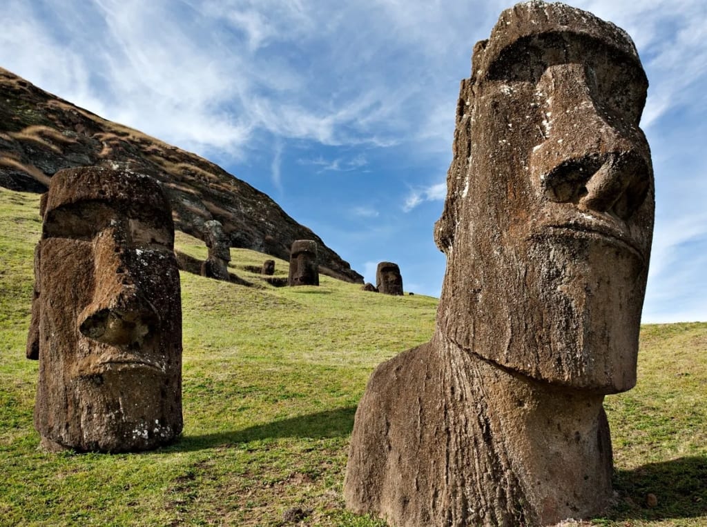
The enigmatic Easter Island giant heads, or moai statues, have captivated the world's imagination for centuries. Even today, they hold such significance that they boast their own emoji. While their true purpose remains shrouded in mystery, researchers have shed light on how these colossal statues were crafted and transported to their iconic locations. Each moai statue comprises three distinct parts: a large yellow body, a red hat or top knot, and white inset eyes adorned with coral irises. Astonishingly, over a thousand of these awe-inspiring creations were crafted on the island. The primary material used for their construction was volcanic tuff, sourced from a local quarry nestled within a former volcano. The choice of volcanic tuff facilitated the carving process, but it also presented a considerable challenge in the transportation phase.
Archaeologists stumbled upon over 300 unfinished moai statues at the quarry, indicating the daunting task the ancient builders faced. The process of bringing these massive figures to life began with carving them while lying on their backs. Once the intricate details were complete, the creators painstakingly detached the statues from the rock and moved them down the slopes to their intended sites. There, the moai were positioned in a commanding vertical stance, seemingly watching over the villages with an air of protective guardianship. Transporting the statues to their designated platforms was no small feat, as evidenced by the unfinished moai left behind. The effort required to move these colossal stone figures was akin to moving houses, an arduous physical endeavor demanding ingenuity and cooperation from the island's inhabitants.
Despite the passage of centuries, the moai statues continue to stand tall, an enduring testament to the island's ancient civilization and their remarkable engineering skills. The Easter Island giants remain as enigmatic guardians of history, their mysteries inspiring curiosity and wonder in all who behold their majestic presence. As the world marvels at these awe-inspiring monoliths, the quest to unravel the true purpose behind their creation continues, leaving us captivated by the riddles of Easter Island. Imagine the herculean task of moving statues weighing almost as much as a house, without the aid of cars or modern machinery, across a vast distance of three miles. On Easter Island, this remarkable feat was accomplished centuries ago, and the ingenious methods employed by the island's inhabitants have intrigued scientists for years.
To unlock the secrets of how the ancient Rapa Nui people transported the moai statues to their final destinations, researchers embarked on a mission to recreate the process. One method tested involved pulling moai replicas on wooden sleds, while another hypothesis speculated that palm trees might have been used in some way. However, these theories were eventually debunked as not providing a feasible solution to the colossal challenge. The most promising experiment involved leveraging ropes to rock the statues back and forth in an upright position, a method that has shown some success in mimicking the statues' movement. The moai appeared to "walk" from the quarry to their intended sites, showcasing the ingenuity and resourcefulness of the ancient islanders.
Of course, to facilitate the transportation of these massive statues, a well-constructed road would have been essential. In the early 20th century, researcher Catherine Rutledge made a groundbreaking discovery when she identified an 800-year-old road network on Easter Island. This network of ancient thoroughfares served as the arteries through which the moai statues made their arduous journey. The Rapa Nui people's mastery in moving these immense stone figures stands as a testament to their engineering brilliance and determination. Despite the passage of centuries, their methods continue to awe and inspire, leaving us marveling at the enduring legacy of the moai statues. As we walk the same paths that these colossal guardians once trod, we are reminded of the island's rich history and the indomitable spirit of its ancient inhabitants.
Intriguing mysteries enshroud the ancient roadways of Easter Island, a network of pathways approximately 15 feet wide that crisscrossed the landscape. For years, there was speculation regarding the purpose of these enigmatic roads. Early theories proposed that they might have held ceremonial significance, serving as sacred routes for ancient rituals. However, these ideas didn't gain much traction, and the roads remained shrouded in obscurity. Decades later, renowned Norwegian adventurer and archaeologist, Thor Heyerdahl, stepped forward with a groundbreaking hypothesis. He asserted that these roads were purposefully constructed for one monumental task: transporting the colossal moai statues. According to Heyerdahl's theory, the roads were carefully engineered to facilitate the challenging journey of the statues from the quarries to their designated platforms.
However, it wasn't until 2010 that conclusive evidence emerged, shedding light on the truth behind Heyerdahl's theory. Meticulous research revealed that the statues weren't haphazardly dropped along the roads, as some had speculated. On the contrary, they were deliberately positioned on hidden platforms at their final destinations. Moreover, the surface of the roads was U-shaped, which presented an additional challenge to pulling massive statues along them. The precision and engineering involved in ensuring the safe arrival of the moai was awe-inspiring.
Today, around 15.5 miles of these ancient roads can still be found on the island. Their significance stretches far beyond mere relics of the past; they are a testament to the ingenuity and determination of the Rapa Nui people. Satellite images offer a glimpse of this remarkable network, providing a window into the island's ancient engineering marvels. As the mysteries of Easter Island continue to unfold, the roads remain an enduring enigma. Each pathway whispers the secrets of a bygone era, reminding us of the ingenuity and brilliance of the people who once traversed these sacred routes. The ancient roads stand as silent witnesses to the timeless wonders of Easter Island, inviting us to ponder the incredible journey of the moai statues and the remarkable civilization that left its indelible mark on this remote and mystical island.
Unraveling the secrets of ancient civilizations has always captivated the minds of researchers and historians. One such enigmatic site that continues to mystify experts is the iconic Stonehenge in Southern England. This awe-inspiring structure, comprised of approximately 100 upright stones forming a mesmerizing circle, has puzzled scholars for generations. Constructed over a staggering 1500-year span by Neolithic builders, Stonehenge stands as a testament to the ingenuity and determination of ancient civilizations. As tourists from all corners of the globe flock to witness its grandeur, the monument's purpose remains shrouded in uncertainty.
Numerous theories have emerged over the years, each attempting to decipher the riddle of Stonehenge. Some propose that it was a sacred place of pilgrimage, drawing worshipers to a revered volcano. Others believe the standing stones served as symbolic signposts or a burial ground, commemorating the lives of those who once inhabited this sacred space. In recent times, the preservation of Stonehenge has been a paramount concern for heritage protectors. Fears of the modern road encroaching upon this ancient marvel spurred action to safeguard its integrity. A once worrisome road, snaking close to the monument, has now been thoughtfully sunken below the grass level. Archaeologists, in a quest for deeper understanding, ventured beneath the surface, where they made an unexpected discovery.
Unearthing layers of history, they found not only the expected modern road but also an earlier path buried beneath it. These parallel ditches, nearly perpendicular to the road, hint at an older journey leading to the heart of Stonehenge. As scientists continue to peel back the layers of time, the mystery of Stonehenge endures. The timeless allure of this ancient site beckons us to delve into its past, seeking answers to questions that have spanned generations. Stonehenge stands as a captivating enigma, a silent witness to the secrets of the past, inviting us to ponder the purpose of its creation and the remarkable culture that left this enduring legacy in stone.
The recent discoveries surrounding Stonehenge continue to shed light on its ancient significance and the purpose it served for the people of the time. Archaeologists have uncovered evidence of an ancient pathway leading up to the monument, connecting the shortened sections of what is now known as the "avenue." This finding suggests that the site was a destination for gatherings, ceremonies, or other important activities, drawing people from afar to its sacred grounds.
During a dry summer, another intriguing revelation emerged – three distinct dry patch marks within the stone circle. These marks appear to indicate the original locations of three massive boulders that may have completed the circle, implying that Stonehenge was once a fully enclosed structure. As experts continue their investigations, the secrets of Stonehenge's complete form are slowly being unveiled. In another part of the world, amidst the Venetian Lagoon, a submerged Roman road has emerged as a testament to the mastery of Roman engineering. Scanning technology has revealed the impressive extent of this ancient road, stretching nearly 4,000 feet along the lagoon's bottom. This finding serves as compelling evidence of the Roman presence in the area long before the rise of Venice.
The discovery of the submerged Roman road supports the theory that a significant settlement existed in the region prior to Venice's establishment in the 5th century CE. The Romans were renowned for their road-building prowess, and it appears they weren't deterred by challenging terrains. Constructing this road directly on the beach required exceptional engineering skills, a testament to the Romans' ability to conquer even the trickiest landscapes.
As we unearth the secrets of the past, these remarkable findings underscore the enduring legacy of ancient civilizations and the astonishing feats they accomplished. Stonehenge and the submerged Roman road remind us of the intricate connections between our present and the fascinating history that lies beneath the surface, waiting to be uncovered by the relentless pursuit of knowledge. Imagine stepping into a time capsule and being transported back over a thousand years, witnessing a village frozen in time. That is precisely what researchers discovered in 2011 when they stumbled upon an ancient Maya village named Sarin in modern-day El Salvador. Preserved by a dramatic natural event, this village offers a fascinating glimpse into the lives of its inhabitants over 1400 years ago.
The story of Sarin unfolds with a tragic mass celebration turned catastrophic. On that fateful day, the entire village gathered at the main Temple, bustling with excitement as they prepared for a momentous ritual. But destiny had other plans. A nearby volcano erupted suddenly, casting a dark shadow over the festivities. Panic ensued as the 200-plus residents realized the imminent danger, leaving them with no choice but to abandon their preparations and flee for their lives.
The fleeing villagers raced southward along a raised road known as Sock Bay, desperately trying to escape the engulfing plumes of volcanic ash. The urgency of the situation left no time to return to their homes or gather their belongings. As a result, the village remains frozen in a haunting scene of half-eaten food left on tables and personal items discarded in haste, offering an authentic snapshot of a moment suspended in time. As if saving lives wasn't enough, the Sock Bay road had an intriguing feature that added to the mystique of the place. All Sac Bay roads were typically paved with an outer layer of stones, but this particular road was constructed with a unique twist – it was crafted from the very volcanic ash that had engulfed the village. The irony is undeniable, as the ash that caused devastation also played a role in preserving the road itself.
Walking through Sarin is like peering into the past, a vivid reminder of the ebb and flow of human history, where lives and legacies are shaped by the forces of nature. The extraordinary discovery of this ancient Maya village presents an opportunity for researchers to delve deeper into the customs, rituals, and everyday lives of the Maya people. As we continue to unravel the secrets of this remarkable find, Sarin remains a powerful testament to the resilience of humanity and the enduring mysteries that await our exploration.
In the heart of Jerusalem, archaeologists unearthed a remarkable discovery that sheds new light on the ancient Roman era. During an excavation of an old street, they stumbled upon an array of ancient coins, hinting at a hidden story behind the road's construction. As they scrutinized the minting dates, a fascinating revelation emerged - the road was built during the reign of none other than Pontius Pilate, the Roman governor of Judea. This finding not only adds a historical context to the road's origin but also raises intriguing questions about its purpose.
Pontius Pilate's role as the local ruler makes it highly likely that he ordered the construction of this road. It is believed that pilgrims of that era might have trodden this very path, journeying towards the sacred Temple Mount for worship and religious ceremonies. Stretching over a significant distance and laid with over ten thousand tons of limestone, the road's width was comparable to the length of a modern London bus. This luxurious thoroughfare has stood the test of time, remaining intact for an astonishing 2,000 years.
What remains a puzzling enigma is the reason behind the lavish expenditure on this road. Why would a Roman governor invest such substantial resources in its construction? One plausible explanation is Pilate's strategic desire to earn the favor of the city's inhabitants. By providing them with a grand and functional road, he hoped to win their approval and strengthen his position as a respected leader. Additionally, showcasing his financial prowess and influence through this grand project was a subtle way of asserting his authority over the region.
While the exact motivations may remain shrouded in the annals of history, the discovery of this well-preserved Roman road unveils an intriguing snapshot of the past. It offers a glimpse into the ambitions and aspirations of Pontius Pilate as he sought to leave an enduring mark on the ancient city of Jerusalem. As archaeologists continue to unearth secrets from beneath the ground, this luxurious road stands as a testament to the remarkable engineering feats and the enduring legacy of the Roman era in one of the world's most historic cities.
The Old North Trail weaves an extraordinary tapestry of human history, tracing back over 10,000 years to a time long before the arrival of the first Europeans in North America. This ancient highway was once traversed by intrepid travelers on foot, accompanied by loyal canine companions, and eventually by swift horses. A network of paths spanning thousands of miles, it served as a lifeline for early inhabitants, facilitating trade, kinship bonds, and exploration even during the harsh conditions of the last ice age.
As researchers delve deeper into the lore and legends of the Blackfoot Indians, they are continually uncovering tangible evidence that supports the authenticity of this trail. In fact, there is a compelling possibility that the Old North Trail played a vital role in one of the largest human migrations in history - the epic journey of people who crossed over from Asia via the Bering land bridge some 15,000 years ago and settled in the vast expanses of North America. It is believed that these early pioneers may have traversed the ice-free corridor along the Rockies, which eventually merged with the trail itself.
The significance of the Old North Trail cannot be overstated; it was not merely a means of transportation but a conduit for cultural exchange and shared experiences. For countless generations, it connected communities, facilitated trade of essential goods, allowed people to reunite with distant relatives, and played a pivotal role in finding life partners. From ancient times to the present day, this historic pathway has been an emblem of human resilience and adaptability, with its echoes resonating throughout the annals of time.
Switching gears to a different corner of the world, we find the Nakasendo Highway, a marvel of engineering and a testament to Japan's rich cultural heritage. Built during the 17th century, precisely during the Edo period, this highway served as a crucial artery of communication between Edo, present-day Tokyo, and Kyoto, the imperial capital. The Nakasendo Highway bore witness to the steady pulse of Japanese society, allowing merchants, pilgrims, and travelers alike to traverse the majestic landscapes of Japan.
Both the Old North Trail and the Nakasendo Highway stand as remarkable testaments to the indomitable human spirit and the unwavering drive to explore, connect, and forge lasting bonds across vast distances. These ancient highways, with their timeless stories etched into the very fabric of the lands they traverse, remind us of the remarkable resilience and enduring legacy of humanity's journey through time. As researchers continue to unearth their secrets, we are offered glimpses into the intricate tapestry of our shared history, inviting us to marvel at the footsteps of our ancestors and the paths they paved for the world we inhabit today.
The Nakasendo Highway, a remarkable 310-mile road, served as a vital lifeline between Kyoto and Tokyo during Japan's illustrious Edo period. This scenic route traverses majestic mountain ranges and gracefully descends onto the plains, offering travelers an awe-inspiring journey through Japan's picturesque landscapes. Akin to a grand symphony, the Nakasendo Highway played a pivotal role in the socio-political fabric of the time, as one of the five main roads used by feudal lords and their families to journey to the capital city.
Along the 310-mile stretch, there were 69 post stations thoughtfully scattered, offering weary travelers a place to rest their heads for the night. Designed with horses and pedestrians in mind, the Nakasendo Highway was tailored to the specific needs of the time. The Japanese, in their wisdom, did not rely on carts, so the road catered exclusively to foot traffic and equestrian travel. Today, echoes of this rich history still resonate, as parts of the route remain accessible, allowing modern adventurers to step into the footsteps of ancient travelers.
The Nakasendo Highway stands as a poignant reminder of Japan's heritage and the remarkable interconnectedness of its cities and people during the Edo period. Through the lens of this historic road, one can witness the bustling movement of feudal lords and their entourages, the vibrant exchange of cultures, and the enduring legacy of Japan's remarkable history. As time marches forward, the Nakasendo Highway continues to be a cherished cultural treasure, inviting travelers to immerse themselves in its enduring allure and be captivated by the timeless beauty of Japan's landscapes.
About the Creator
Daniel Fuentes Hermosa
"Awakening minds to resist NWO's grip. Self-care as my rebellion - mind, body, soul united. Unbreakable spirit in a chaotic world. #Resilience #TruthSeeker"
Keep reading
More stories from Daniel Fuentes Hermosa and writers in History and other communities.
Eternal Echoes
Step aboard the grandest marvel of its time, the RMS Titanic, as it embarked on a historic journey from England on that fateful April 10, 1912. This wasn't just another ship setting sail; no, the Titanic was a breathtaking behemoth, a colossal liner that outshone all others. Stretching an astonishing 882 feet, it boasted a length almost equivalent to three vast soccer fields. And when you gazed up at its towering magnificence, you'd find yourself staring at an awe-inspiring 175-foot tall structure, matching the height of a staggering 17-story building!
By Daniel Fuentes Hermosa10 months ago in History
What can be find under the terrible sea
The world's abysses are vast and largely unexplored, covering over 70 of the Earth's face and containing some of the most mysterious and portentous marvels known to humankind. The middle of the ocean can be both admiration- inspiring and frighting,
By vinoth kumar7 days ago in History


Comments
There are no comments for this story
Be the first to respond and start the conversation.