
America's Forgotten Concrete Arrows
Have you ever heard of this?

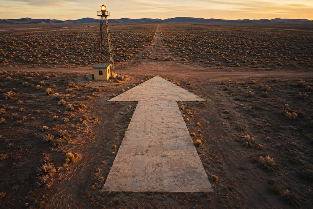
Imagine you're hiking through a lonely stretch of desert in the American West. The landscape is silent except for the wind; sagebrush sways in the distance, and the nearest highway is miles away. Then, without warning, you stumble across something that makes absolutely no sense: a gigantic concrete arrow. It stretches nearly seventy feet across the ground, pointing toward an empty horizon. There are no roads nearby, no signs explaining its purpose, no obvious destination. Just an enormous arrow, weathered by decades of sun and rain, as though some long-forgotten civilization left behind a monument no one bothered to explain. It sounds like the beginning of a mystery novel, but instead, it's one of the most fascinating chapters in American engineering history.
Long before satellites, radar, or GPS guided airplanes across the country, the United States built an extraordinary coast-to-coast navigation system that relied on something remarkably simple: giant concrete arrows and rotating beacons. To understand why they existed, you have to step back to the early 1920s, when aviation was still finding its wings. Flying was a dangerous business; commercial aviation barely existed; aircraft were primitive; weather forecasting was unreliable; and most pilots navigated the same way travelers had for centuries: they simply looked out the window. Rivers, railroad tracks, mountain ranges, and towns became their maps. If clouds rolled in or darkness fell, pilots often had little choice but to land and wait until daylight.
This presented a serious problem for the rapidly growing U.S. Air Mail Service. Mail couldn't simply stop moving because the sun went down. The government needed a way for pilots to fly safely across hundreds of miles of unfamiliar countryside, even at night. Their solution was breathtaking in both its ambition and its simplicity: they built a highway in the sky.
Across thousands of miles of American landscape, crews constructed an enormous chain of navigation stations. Roughly every ten to fifteen miles stood a tall steel beacon tower equipped with a powerful rotating light. During daylight hours, pilots could locate the next station by spotting a massive yellow concrete arrow beneath the tower, each arrow pointing directly toward the next beacon and creating an uninterrupted visual trail stretching across the country. One arrow led to another, and another, and another. Eventually, the system connected the East Coast with the West Coast, allowing pilots to cross America by simply following a sequence of glowing lights at night and giant arrows during the day. Today it sounds almost unbelievable, yet for the pilots of the era, these arrows were as essential as modern GPS satellites are to us.
Each station was remarkably self-sufficient. Small buildings housed electrical equipment and backup generators to keep the rotating beacon operating after sunset. The towers themselves often stood around fifty feet tall, making them visible from impressive distances. When darkness settled over the landscape, pilots could watch one beacon fade behind them as the next appeared ahead, creating a reassuring chain of lights guiding them safely through the night. For the first time, coast-to-coast airmail became practical around the clock, transforming aviation.
Mail that once required days of unpredictable travel could now move across the nation with far greater speed and reliability. The beacon network proved so successful that it helped lay the foundation for America's rapidly expanding commercial airline industry. What began as an aid for airmail pilots soon became part of the nation's growing aviation infrastructure. At its height, the network stretched across more than 18,000 miles of designated airways and included roughly 1,500 beacon stations. One of the largest navigation systems ever built using nothing more complicated than concrete, steel, electricity, and careful planning.
Of course, technology never stands still. During the 1930s, radio navigation systems began replacing visual navigation. Pilots no longer had to depend solely on what they could see from the cockpit. Electronic signals allowed aircraft to fly more accurately, even through poor visibility. As aircraft became faster and more sophisticated, the concrete arrows gradually became unnecessary.
Then came World War II. Fearing that enemy aircraft might use the beacon network for navigation, many of the illuminated towers were dismantled or switched off. Some concrete arrows were intentionally removed or concealed, while others were simply abandoned where they stood. Nature slowly reclaimed them, grass grew over their edges, sand drifted across them, and trees surrounded them. Entire generations passed without realizing that enormous arrows were quietly resting beneath the American landscape.
Ironically, the very thing that made them obsolete also helped preserve them: concrete doesn't disappear easily. Unlike wooden buildings or steel towers that rusted away, the arrows remained. Hidden in deserts, tucked into forests, perched on mountaintops, or resting beside forgotten service roads, many still survive nearly a century after they were poured. Some are pristine enough that their purpose is immediately obvious from the air, while others are so weathered that only careful observation reveals their distinctive shape.
Thanks to satellite imagery, drone photography, and curious historians, these forgotten landmarks have experienced an unexpected revival. Explorers now seek them out as relics of an era when aviation relied as much on eyesight and courage as on machinery. What was once cutting-edge infrastructure has become an accidental outdoor museum scattered across the American landscape.
Perhaps the most remarkable aspect of the story isn't the engineering itself, but how completely it faded from public memory. Millions of Americans have flown across the country without realizing that today's invisible navigation systems owe a debt to a nationwide network of concrete arrows and rotating lights. We marvel at GPS satellites orbiting thousands of miles overhead, yet few remember the humble arrows that once guided pilots safely home using nothing more than a painted point aimed at the horizon.
There is something wonderfully American about the entire endeavor. Faced with an enormous challenge, engineers didn't wait for futuristic technology to arrive. They solved the problem using the tools they already had: steel towers, electric lights, and concrete arrows. It was practical, ingenious, and astonishingly effective.
Today, those silent arrows remain scattered across the nation, pointing toward destinations that modern aircraft no longer need. Most travelers pass within miles of them without ever knowing they're there. They have become ghosts of an earlier age, monuments not to war or politics, but to innovation.
Sometimes history isn't hidden in museums. Sometimes it's lying quietly in the desert, pointing toward the next adventure, patiently waiting for someone to ask the same question that countless explorers have asked before:
"Why in the world is there a giant concrete arrow out here?"...
About the Creator
The Iron Lighthouse
Where folklore meets freeway. A guide to the strange heart of the American backroads...
Enjoyed the story? Support the Creator.
Subscribe for free to receive all their stories in your feed.
Comments
There are no comments for this story
Be the first to respond and start the conversation.