
ESCAPE ROUTE INCASE OF KIDNAPPING
Navigate Your Way After Getting Lost/Kitoed

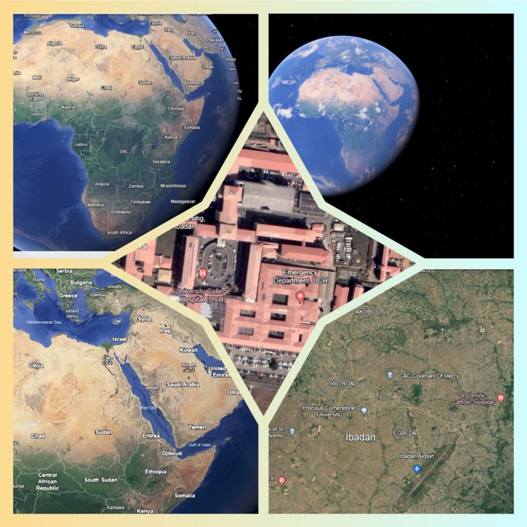
Introduction to Google Earth
Google Earth is a computer program that renders a 3D representation of Earth based primarily on satellite imagery. The program maps the Earth by superimposing satellite images, aerial photography, and GIS data onto a 3D globe, allowing users to see cities and landscapes from various angles. Users can explore the globe by entering addresses and coordinates, or by using a keyboard or mouse. It's also enabled on the mobile app for easy access for the masses.
Using Google Earth to Escape When Kidnapped
Similar App which has been built alongside with all mobile devices known as Maps. It does the same work as Google Map while some devices can also support the Google Map download!
While being kidnapped is a highly stressful and dangerous situation, there are theoretical ways in which Google Earth might assist in such circumstances. Here’s how:
Planning an Escape Route
If a kidnapped individual has access to a device with Google Earth and an internet connection, they could potentially use it to plan an escape route. Here’s a step-by-step approach:
- Identify Location: The first step is identifying the current location. This can be done by observing notable landmarks, street names, and other geographical features on your mobile Map or Google Map.
- Locate Safe Zones: Using Google Earth, the individual can identify nearby safe zones such as police stations, hospitals, or other public places where they can find help.
- Plan Route: Once the current location and the destination are identified, the individual can plan the safest and quickest route. Google Earth’s detailed maps and street views can help identify back alleys, less crowded streets, and other features that might assist in evading pursuers.
- Check Terrain: The terrain feature of Google Earth can help in understanding the geographical layout, such as hills, forests, and water bodies, which might be crucial in an escape plan.
Communicating Location
If the individual has access to a communication device:
- Share Coordinates: Google Earth allows users to find the exact coordinates of their location, which can be shared with authorities or trusted individuals.
- Send Visual Clues: Screenshots or descriptions of the surroundings, as viewed in Google Earth, can be sent to help others pinpoint the location.
Staying Informed
Even without the ability to move freely, Google Earth can provide information about the surrounding area:
- Identify Nearby Resources: Knowing the location of nearby resources such as water sources, food outlets, or places to hide can be crucial.
- Understand Patterns: Observing the layout of the area, such as traffic patterns and pedestrian routes, can help in planning the best time and way to attempt an escape.
Navigation in Google Earth
Basic Navigation
Zooming In and Out: Users can zoom in and out using the mouse wheel, the plus (+) and minus (-) keys, or by clicking the zoom buttons on the screen.
Rotating the View: The compass tool allows users to rotate their view to see different perspectives.
Tilting the View: Users can tilt the view to see 3D terrain and buildings using the tilt slider or by holding the right mouse button and moving the mouse.
Moving Around: Users can click and drag the mouse to move the view around the globe, or use the arrow keys for navigation.
Search Function: The search bar allows users to enter addresses, coordinates, or place names to quickly navigate to specific locations.
Advanced Navigation
Street View: By dragging the Pegman icon onto streets, users can enter Street View mode, allowing them to see panoramic views of streets.
Historical Imagery: Users can access historical imagery to see how locations have changed over time by clicking the clock icon.
Voyager: This feature provides guided tours of various locations, with thematic content from Google and partners.
3D Buildings: Users can view and navigate 3D models of buildings and structures in major cities.
Uses of Google Earth
Education: Google Earth is widely used in educational settings to teach geography, history, environmental science, and more. Students can explore different parts of the world, view historical sites, and understand geographic concepts better.
Urban Planning: Urban planners use Google Earth to view and analyze geographic data, visualize planning scenarios, and present ideas to stakeholders.
Environmental Monitoring: Environmentalists and scientists use it to track changes in the environment, such as deforestation, glacier melt, and urban expansion.
Travel Planning: Travelers use Google Earth to explore destinations, check out landmarks, and plan their trips.
Real Estate: Real estate professionals use Google Earth to show properties to clients and analyze neighborhood features.
Disaster Response: During natural disasters, responders use Google Earth to assess damage, plan relief efforts, and coordinate with other agencies.
Advantages of Google Earth
Accessibility: Google Earth is accessible to anyone with an internet connection and provides a wealth of geographic information for free.
Detailed Imagery: It offers high-resolution imagery and detailed information about the world's geography.
User-Friendly: The interface is intuitive and easy to use, allowing users of all ages to navigate the globe.
Educational Value: It is an excellent tool for learning and teaching about the world, offering interactive and engaging content.
Real-Time Data: Google Earth can display real-time data like weather patterns and traffic conditions.
Customization: Users can create custom maps, add their own data, and share it with others.
Disadvantages of Google Earth
Data Limitations: Some areas may have outdated or low-resolution images, and the frequency of updates can vary.
Privacy Concerns: High-resolution imagery can raise privacy issues, especially with Street View capturing images of people and properties.
Internet Dependency: It requires an internet connection, which can be a limitation in remote or underdeveloped areas.
Technical Requirements: High-resolution and 3D views can be demanding on hardware, requiring a relatively powerful computer for the best experience.
Misuse: Detailed images and data can potentially be misused for harmful purposes, such as planning criminal activities.
In conclusion, Google Earth is a powerful tool that offers numerous advantages, including accessibility, detailed imagery, and educational value. However, it also has limitations such as data inaccuracies and privacy concerns. While it can theoretically assist in planning an escape during a kidnapping, the practical application would depend on the specific circumstances and the individual’s ability to use the technology under duress.
In summary, Google Earth is a versatile tool that has revolutionized how we view and interact with our world. Its uses span across education, urban planning, environmental monitoring, and more. Despite some disadvantages, its benefits and applications far outweigh the negatives, making it an invaluable resource in many fields.
About the Creator
Victor Obanor Osagie
As a Nigerian author, My pen wields the power to transport readers into vibrant landscapes rich with culture, tradition, and human complexity. With a keen eye for detail and a heart that beats to the rhythm of my homeland Nigeria
Enjoyed the story? Support the Creator.
Subscribe for free to receive all their stories in your feed. You could also pledge your support or give them a one-off tip, letting them know you appreciate their work.
Keep reading
More stories from Victor Obanor Osagie and writers in Lifehack and other communities.
EARN WITH YOUR INSTAGRAM
OVERVIEW Instagram monetization refers to the various ways that users, particularly content creators, influencers, and businesses, can generate income through their activities on the Instagram platform. This involves leveraging their content, audience, and influence to earn money directly from Instagram or indirectly through partnerships and sales.
By Victor Obanor Osagie 16 days ago in Lifehack
How Can Car Valeting Help Prevent Rust and Corrosion?
Car valeting plays a significant role in maintaining the overall condition of a vehicle. A well-maintained car not only looks good but also functions efficiently. One critical aspect of car maintenance is preventing rust and corrosion. This article will explore how car valeting helps in preventing rust and corrosion, along with a detailed overview of the services provided by car valeting companies, including Click Valet.
By Click Valet4 days ago in Lifehack


Comments
There are no comments for this story
Be the first to respond and start the conversation.