


In Sri Lanka, Yahangala is a highly well-liked trekking location. Local visitors are more inclined to visit than tourists from other countries. This peak is known as "Bed Rock" by some. It stands at a height of 1220 meters above sea level and is another mountain in the Knuckles Mountain Range. The location is part of Kandy District's Udadumbara Divisional Sectarian region. Additionally, Kandy is 60.2 miles distant (it will take around 1 hour 44 minutes). For people who enjoy hiking, trekking, adventure sports, and camping, this is a fantastic location.
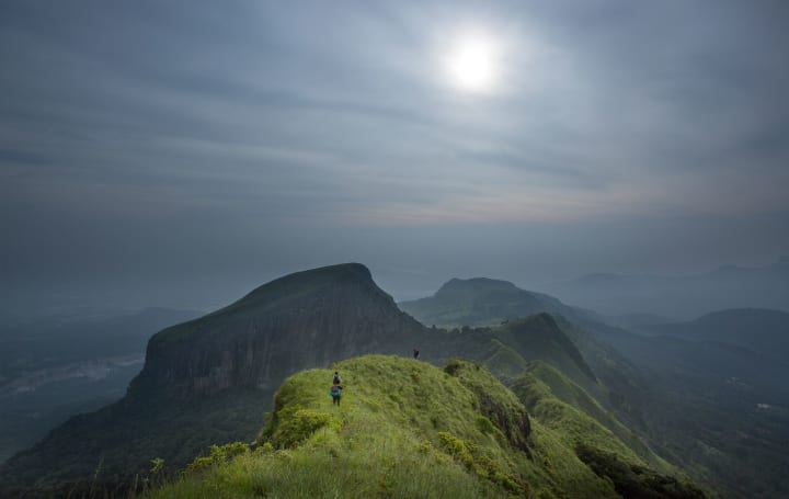
A huge flat region is covered by Yahangala's summit. One of Yahangala's wonders, according to locals, is the absence of large trees. The location is perfect for a campsite and offers breathtaking 360-degree views. From the peak, one can view the "Mahaweli River," "Kehelpathdoruwa," and all three of these landmarks. This object is known as a "yahangala" because of its bed-like appearance. Yahangala is positioned southeast of Knuckles. The topmost part of the Yahangala rock is around two or three acres in size. The entire mountain is exposed to the air, and you may travel both ways. There were no fountains or trees to be found; only broken pieces of stone covered the ground.
The powerful monarch Ravana is resting in Yahangala till he awakens once more. This location is also thought to be guarded by the god "Gal Bandra." Travelers must come here with good intentions since there have been enough occasions when those with evil intentions have been punished by the environment or by certain spiritual forces. (Elephant attack, wasps, poisonous snake bites of various types, and being lost.) You are good to travel as long as you respect the plants and animals and simply leave your footprints behind.
There is a purpose to the moniker "Bed Rock." People think that the Yahangala is where the "Great King of Ravana" was killed. The epic Ramayanaya story claims that King Ravana was defeated by King Rama. Then King Ravana's lifeless body was buried in the Yahangala. The region is regarded as the conflict's battleground. Some of the other locations that come together with the Tale of Ravana include Lakegala and Rathna Ella.
This plain may be found immediately below the Yahangala. It includes a huge region. Another peak in the Wellangolla Plains is called Lakegala. On these plains, you may witness savanna-like flora and fauna. There are a few lone trees here and there. There are Mana trees everywhere. However, for wild elephants, this is heaven. More than 15 wild elephants have been observed roaming the region. When compared to other Asian elephants, these ones are not extremely tall. You can travel over these plains if you set out from the Hasalaka or Medakale areas.
The folks communicate in a cordial manner. The locals will undoubtedly assist you if you experience difficulty locating the right path. The route first runs alongside a little woodland. You may reach a wide region after an hour of walking. The Yahangala Mountain that has suddenly materialized in front of you is now plainly visible. It is a location where the majority of hikers camp. The surroundings are incredibly stunning, and Kehelpathdoruwa Mountain is clearly seen from a distance. You now have two options to choose from Yahangala or Kehelpathdoruwa. It is not feasible to hike to both locations in a single day. Two days must be set aside for the entire journey.
History
This rock is said to hold King Rawana's remains, according to mythology. He is Yahangala's most well-known inhabitant. The mythological character "Ravana" is claimed to have been killed by Lord Rama and placed to rest on this rock. On the left side of "Yahangala," it is rumored that the king's remains are interred. Yahangala is not for the weak of the heart to reach. Another local god named "Gale Bandara" is said to guard "Yahangala."
The phrase was created by an old myth about the villages of the monarch visiting this rock to pay their respects to their great king, who was buried there. Yahangala is a Sinhala term that means "bedrock."
Hiking to Yahangala
Yahangala mountain, one of Sri Lanka's most stunning mountain ranges, is situated in a rural community about 15 kilometers north of Ududumbara. It takes around six hours to ascend and return to the trailhead. You'll need a local guide for a number of reasons, and if you're taking a big group up the mountain, you'll probably need permission from the local authorities.
There are two portions of the trek. About three-quarters of the hike's height is covered by the first section, which comes to an incredible conclusion on a grassy plain. Essentially a difficult rock to climb and descend, the second portion. The majority of hikers would thus find the trek difficult. Only individuals with a reasonable level of physical fitness should attempt to climb in. To complete this phase, you will require a local guide's assistance.
From Uda Iluka, a direct pathway leads to Velangolla Pathana. At first, there is a little area of woodland, then come Mana bushes. After an hour of driving along this road, you can arrive at Velangolla Pathana, where you can see a variety of wildlife. A water pipe was in the way of pedestrian traffic.
Access to Udagaldebokka is by a trail. You may view Dewalayas from where you are going. Yahangala is on the right, while Kehelpothadoruwegala is to the left. When you're utilizing Velangolla Pathana, it's risky to stroll there. Elephants wandering freely frequently use this route. Yahangala's peak is reachable by climbers from the mountain's backside. This will be an opportunity of a lifetime. It should take around two hours to get to the peak.
This walk takes you through Sri Lanka's magnificent natural beauty. Go on a trip. You'll have the opportunity to see a wide range of settings, many of which have breathtaking vistas.
- Food and water should be mandatory. There are no water sources on the mountain’s summit.
- If you have no prior experience with pilot hiking or rope climbing, it is recommended that you hire a local guide to assist you.
- Make use of a leech repellant.
- Keep an eye out for elephants in the wild.
Climate and Weather
The average annual rainfall in the region is about 2500mm. In the Udadumbara region and its environs, October through February are regarded as the rainy season. The primary cause of rainfall is the North-East monsoon. However, from May to September there is a definite dry season. In May and June, the wind speed is significantly higher. Savana-like forests have developed in Yahangala and the surrounding areas as a result of these climate changes. During the dry season, people encounter numerous challenges.
The average yearly temperature ranges from 19 to 23 degrees Celsius. After ascending both of these mountains, you will experience extreme cold. Compared to other months, December and January are substantially colder. In Kehelpothdoruwa, the weather can change suddenly. You will be surrounded by fog at any time of day. Additionally, before it starts to rain there, you may see a lot of lightning.

How to get
Yahangala is located on the eastern edge of the Kandy district, as we already said. The Knuckles Mountain Range's southernmost flank is where it is located. The closest town is Udadumbara. The area may be reached by a few different paths. Use the Udadumbara-Kalugala Route, as we advise. Some of them travel from the villages of Hasalaka and Madakale to this location. But using this route is challenging.
If you decide to take the Udadumbara-Kalugala route, you should first visit the village of Udadumbara. Kandy is 45 kilometers from Udadumbara. The Kaluagala route should thereafter be taken. Google Maps shows a 58-kilometer distance between Kandy and Kalugala. Every hour, a bus carrying passengers from Udadumbara to Kalugala is accessible.
When the bus reaches the final stop, get off. You should now continue walking for around 1 kilometer towards the settlement. You will then arrive at the pathway leading to Yahangala. You can pick the right way with the help of the notice boards.
The Summit of the Yahangala
The top is visible from every angle, and it is truly stunning. You'll undoubtedly experience awe. There are a couple of acres of flat land there. On the summit of the mountain, there were no trees. But the entire region is now covered with grass. Stones that have broken are all over the place because of the intense lightning.
Mahiyangana, Sorabora, Hasalaka, Rathkinda Tank, Bibile, Dehiattakandiya, Wasgamuwa, Maha oya, Girandurukotte, 18 Bends, Madakale, Udagaldebokka, Udaththawa, Welangolla Plains, Udadumbara, Kalugala, Poppitiya, Nawanagala, and Deanston are some places you. In addition, the peak of the following mountains can be used to identify them: Kehelpathdoruwa, Lakegala, Dumbanagala, Gerandigala, Nawanagala, Dothalugala, Koboneelagala, Galpadihela, Kokagala, and Knuckles 5 Peaks. Rural communities close to the Yahangala Mountain include Udagaldebokka, Medakale, Udaththawa, and Uda Iluka.

Places Near
- Kehelpathdoruwa
This peak resembles Nepal's, Mount Everest. The Kehelpathdoruwa Mountain has acquired the nickname "Little Everest" as a result. This mountain's top is 1485 meters above sea level. Another incredible journey is the one from Yahangala to Kehelpathdoruwa. There is no easy way to discover it, and it is along the mana bushes. You can reach the peak after walking for a few kilometers. More beautiful than Yahangala is the view from the peak of this mountain. Fantastic views of the Mahiyangana and Welangolla Plains may be seen. It is a fantastic location for photographers to get some incredible images. Another well-known peak that can be seen from Kehelpothdoruwa is Thunhisgala.

- Knuckles Mountain Range
The Knuckles Mountain range is situated in the Matale and Kandy districts of Sri Lanka and is one of the most well-liked trekking locations in the country. The Dumbara range is another name for the mountain range. Of the five peaks in this range that are higher than 1500 meters, Gombaniya is the highest. Among the others that merit note is Kirigalpottha, Knuckles, Koboneelagala, and Dotulugala. This is regarded as a beautiful natural retreat for hikers. On this unforgettable outing, you may go walking, trekking, looking for waterfalls, viewing birds, and doing a ton of other things.
Among hikers, the most popular path is from Kandy to Hunnasgiriya. From a B-grade road near Hunnasgiriya, Corbett's gap offers breathtaking views of the Knuckles range. A town called Meemure may be found in Corbett's Gap. If you prefer, you can also enter through Matale, Rattota, and Riversten or Waththegama, Panwila.

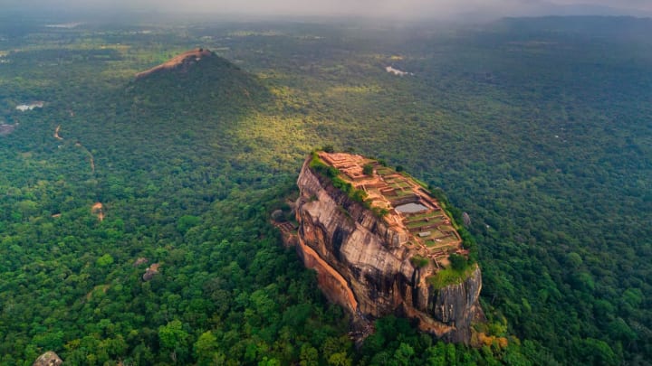
- Sigiriya
In the northern Matale District of the Central Province of Sri Lanka, close to the town of Dambulla, sits the historic rock fortification known as Sigiriya or Sinhagiri. It is a location with a historical and archaeological value that is dominated by a huge granite column that stands 180 meters (590 feet) tall.
This location was once a vast forest, but due to storms and landslides, it was transformed into a hill, and King Kashyapa (477–495 AD) chose it as the site of his new capital. On top of this rock, he constructed his palace, which he then painted with vibrant frescoes. He constructed a huge lion-shaped doorway on a little plateau approximately halfway up the side of this rock. This building gave this location its name, Snhgiri, or the Lion Rock (an etymology similar to Sinhapura, the Sanskrit name of Singapore, the Lion City).
Read : https://zeloan.blogspot.com/2022/07/sigiriya.html
- Gerandi Ella
The Gerandigala mountain in the Kalugala region of Ududumbara, Kandy district, is the source of the Kalugala Gerandi Ella waterfalls. As you go from Kandy to Mahiyanganaya, you will pass by this magnificent waterfall on the left side of the Mahiyanganaya road (A25). This group of seven waterfalls, when combined, rises between 200 and 240 meters in height. From Mahiyanganaya Road, only four of these components are visible.
In Sri Lanka, there are a number of waterfalls with the name Gerandi Ella. This waterfall may be regarded as the biggest of the bunch. Because of its rat snake-like form, the waterfall has that name. Gerandi Ella has an enormous height of 240 meters. This waterfall is challenging to trek because of its challenging steep portions. However, there is a fantastic vista that you have never seen at the top of the waterfall. After taking in Gerandi Ella's natural beauty, you may visit Kulugala village to see its many lovely paddy fields. You will find a lot of inspiration in the wind that is flowing across the paddy fields. As a destination for adventurous camping, this location is well known. Don't forget to bring the necessary camping gear if you're interested in going camping.
Read : https://zeloan.blogspot.com/2022/09/gerandi-ella-in-sri-lanka.html

- Meemure
Meemure is a remote community in Sri Lanka's Central Province that is nestled 324 meters above sea level in the mountains. It can only be accessed from the "Hunnasgiriya" mountain, which is a part of the Knuckles range and is located around 50 kilometers from Kandy. The 33 km trek from Hunnasgiriya to Meemure is challenging with many challenging parts, but the scenery is wonderful. The settlement itself receives an abundance of water in the form of waterfalls that originate in the Knuckles' evergreen forests. The pyramid-shaped Lakegala mountain is located east of the settlement, and the magnificent Knuckles range dominates the west. Meemure's southern and northern boundaries are separated by the Heen River and a forest that extends to the "Pitawala Pathana" grassland.
Up until 2004, pack-bulls were the only means of transportation to Meemure. Cattle herds delivered supplies and equipment to the settlement in bags. Because of the village's abundance and wealth, pack bulls were exclusively used to transport salt, textiles, tobacco, and calcium bicarbonate. However, the trails have been extended to accommodate three-wheelers, jeeps, and compact trucks due to the invasion of modern technology.
Read : https://zeloan.blogspot.com/2022/08/meemure-in-sri-lanka.html

- Sembuwatta Lake
In Matale District, Sri Lanka, Sembuwatta Lake is a man-made body of water created from natural spring water close to Campbell's Lane Forest Reserve. A terrific place to get lost in contemplation and reflect on the amazing sights you've seen while traveling in Sri Lanka is the vast expanse of the deep blue ocean, which is framed by misty mountains and tea gardens.
Sembuwatta Lake, a wonderful location with natural spring water, is one of the hill country's most magnificent attractions. It reflects the natural beauty of the area and is tucked away among the vast tea plants. It is definitely worth the effort to ascend the lovely green mountains with a dense pine forest that tower above the lake. The lake is surrounded by summer houses and cottages, and a pool filled with fresh spring water is located close by.
Read : https://zeloan.blogspot.com/2022/07/sembuwatta-lake-in-sri-lanka.html

- Kandalama
Sri Lankan settlement of Kandalama. It may be found in Central Province. The Dambulla cave temple from the first century BC and the Sigiriya rock fortification from the fifth century AD are the two UNESCO world heritage monuments that stand out for Kandalama.
The 2000-year-old cave temple at Dambulla and the Sigiriya Rock Fortress are both UNESCO World Heritage Sites, and Kandalama is also home to the Kaludiya Pokuna Archeological Forest and one of Sri Lanka's first five-star hotels, Heritance Kandalama.
Read : https://zeloan.blogspot.com/2022/07/kandalama-in-sri-lanka.html

𝗚𝗼𝗼𝗴𝗹𝗲 𝗠𝗮𝗽:
About the Creator
Zeloan
I'm a Traveller, Blogger, and Content Creator. Visit Sri Lanka, and you can see the most beautiful places in the world and the remarkable hospitality here
When the Robots Took My Job
This is for RM Stockton's Write Club prompt for the month of April: AI Please allow me to vent. For "college," I went to a scam school that is now closed. We were promised internships that were never spoken of again after admissions, and we were promised help finding jobs. The first time I went to the career counselor's office, she was completely frazzled. She had no idea what to do with us, the film majors. The second time I visited her office, I let her know that I'd found myself a job, and she was visibly relieved.
By Rebekah Conard4 days ago in Journal
Get Your iLoad Back on the Road: Affordable Petrol Engine
The trusty Hyundai iLoad is a workhorse for many tradesmen, couriers, and adventurers in Australia. However, even the most reliable cars can sometimes experience hiccups along the road, and on such occasions, the hiccups can turn into engine troubles. If you notice that your iLoad's petrol engine that you have relied on for years now starts sputtering, coughing, or throwing up warning lights like some party that goes wrong, then you may have to look into getting an engine replacement. The good news? It is not necessary to spend a fortune to make your loved iLoad run again. Let's take a look at some options and try to search for a Hyundai iLoad petrol engine for sale so that you can be back on road trips again.
By Merry Constatius4 days ago in Journal


Comments
There are no comments for this story
Be the first to respond and start the conversation.