

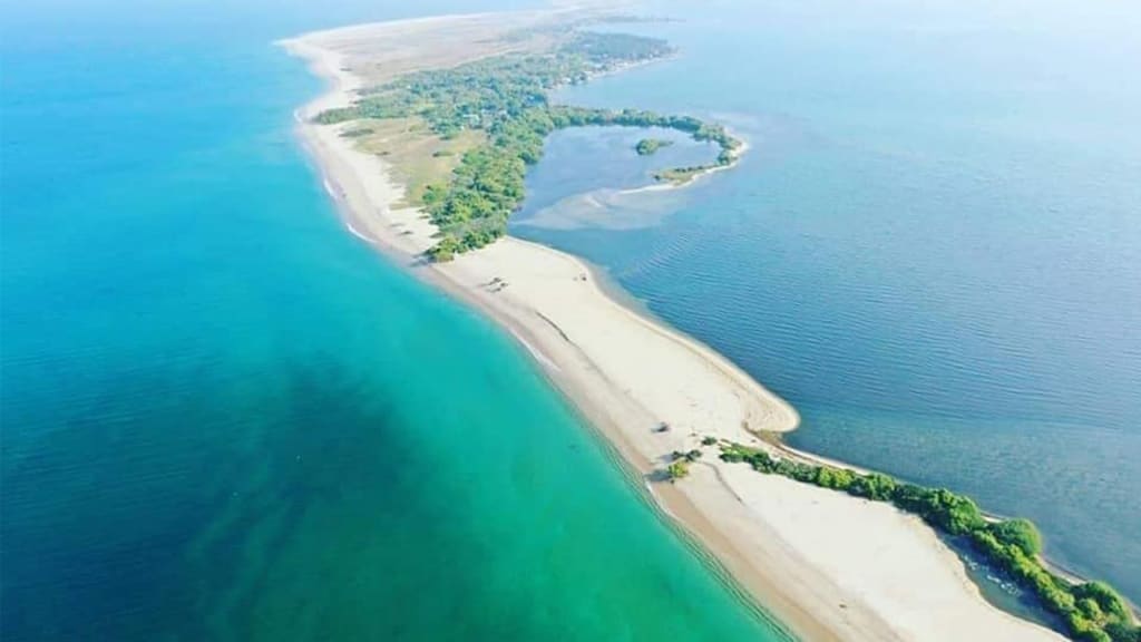
The island of Baththalangunduwa is located 20 nautical miles or 38 kilometers off the coast of Kalpitiya. One of the few inhabited islands off the coast of Kalpitiya, it is a tiny strip of land of about five square kilometers. Although the island was formerly a flourishing fishing community, it has recently gained popularity as a getaway for tourists seeking off-the-beaten-path adventure.
The ferry that travels to the island every day save on Sundays may be found in Kalpitiya, where the voyage to Baththalangunduwa begins. Although local fishermen and boat owners claim that Puttalam is the more direct route to the island, only vessels departing from Kalpitiya are authorized to get there.
Around Rs.10 per person is required to enter the Kalpitiya jetty area, and an additional Rs.50 is required to park a car there. Travelers can then make their way to the ferry boat headed for Baththalangunduwa by navigating the busy jetty. The three-hour boat ride to the island departs at 8.30am as names and identification numbers of passengers are hastily jotted down and coast guard orders to don safety jackets are obeyed by the passengers.

Baththalangunduwa Island's greatest width, measured from east to west, ranges between 680 and 700 meters, and its length from south to north is around 16.0 kilometers. To the north of Puttalam Lagoon, it is one of the few inhabited islands.
The island lacks paved or gravel roadways, but instead features a maze of trails made of thin sand thatch and flanked with homes. On the center and northern parts of the island, you may find mangrove areas, sand dunes, scrub vegetation, and sandy beaches. A few kilometers to the west and northwest of the island lies Bar Reef, a marine sanctuary, and the offshore area known as Pearl Banks is a popular place to watch marine animals including dolphins, whales, dugongs, and porpoises. The east side of the island is bordered by Portuguese Bay, which has a healthy seagrass cover.
Journey
The boat, loaded to the gills with cargo and passengers headed for the island, sputters to life and starts its relatively leisurely voyage from Kalpitiya, passing a number of nearby deserted islands. Regular passengers remove their safety vests once the boat has departed the dock, and many of them settle in for a nap while the ferry and the air gently rock them to sleep. Some people choose to relax and play cards with other tourists while humming a tune.
However, for people who have trouble getting used to the water, the trip may be fairly uncomfortable. Travelers should be careful with their possessions, especially electrical devices, as the water can turn choppy, flinging people around and getting them wet from sea spray. For the older people, who bring plastic sheets, sea spray is not a problem. The key is to position oneself in the middle of the ferry to protect yourself from the onslaught of the waves.

Despite how the sea is acting, taking the ferry to the island is a very other experience. Before arriving to the island, the ferry travels by extensive parts of the Wilpattu reserve on the right. It's normal to observe birds hunting for food and fisherman heading out to sea, but it's also feasible to spot a dolphin or two on occasion.
A volunteer on the boat begins selling tickets for Rs. 250 to each passenger when Baththalangunduwa island, populated with thatched fishing cottages, is visible at the end of the three-hour trip. Passengers are met with grins as they rush off the ferry as it moors, and many are anxious to show the visitors where they need to go on the island. Many of the newcomers who just arrived by boat head straight to church with their families to pray and give thanks to God for their safe homecoming while the tourists roam around attempting to get their bearings. Two things become obvious when one moves about. Fishing and religion are central to the islanders' way of life. The island is littered with thatched fishing houses as well as several Christian shrines dedicated to different saints. Baththalangunduwa has three churches despite being a small island, and according to the fisherman, these churches hold large-scale feasts every year.
As long as visitors bring everything they need, camping is permitted on the island. The island's lack of water can occasionally be a problem. The best months to travel to this island are December through April.

life on Island
However, despite its rough terrain, life on Baththalangunduwa seems unhurried, and the inhabitants seem satisfied despite their struggles. While some fishermen pack sword fish in ice to be exported in the "ice wadiya" under the cautious eye of their "mudalali," others either rest on their boats for a little nap or mend their fishing nets. Numerous fishermen and other employees call the island home; they come from all over the nation, including Negombo, Kalpitiya, Puttalam, and even Kandy. When the catch is excellent, they go to and from their homes on the island. There are no long-term residents on Baththalangunduwa, according to the fisherman. But the Sri Lanka Navy runs a school for kids whose parents bring them to the island during the season so they don't lose out on their education. However, Baththalangunduwa also has its own issues, despite its outward appearance of serenity and tranquility. The number of visitors and locals on the island have decreased over time. According to the boat captain, many people have left the island in recent years in search of opportunities and better schools for their children.
Residents are concerned that Baththalangunduwa Island would someday vanish owing to increasing sea levels. This risk is quite serious to the fisherman because it has already befallen numerous once populated islands in the vicinity. The fishermen are known for fighting, but many of them seem to put those disagreements behind them in order to get along with their fellow fishermen and resume their quest for treasure, according to police officials posted on the island.

Life continues in Baththalangunduwa despite these concerns. Every day around 2:00 p.m., the boat returns to the island to transport passengers to the mainland, leaving Baththalangunduwa behind.
Places Near
- Kalpitiya Dolphins & Whales Watching
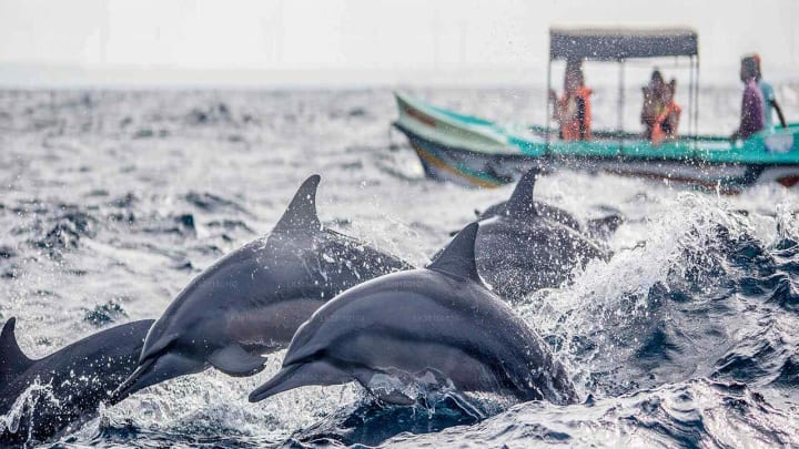
The time of year when dolphins may be seen in the waters around Kalpitiya, which is a popular tourist destination. Dolphins were spotted in shoals in the water off Kalpitiya coast, and tour guides and boatmen who provided facilities to observe dolphins were ecstatic to see them. The best months to watch whales are from November to December and from March to April. The majority of them are sperm whales. There are also sightings of dwarf sperm whales, minke whales, melon-headed whales, and the world's biggest animal, the blue whale. Even orcas have just been captured on camera near Kandakuliya.
Between November and March, super pods (thousands) of dolphins travel to Kalpitiya. The most frequent dolphins to approach the boat for a play are spinner dolphins. Bottlenose, risso, indo-pacific, as well as humpback dolphins are also seen regularly.
- Wilpattu National Park

A national park in Sri Lanka is called Wilpattu National Park (Willu-pattu, "Land of Lakes"). The occurrence of "Willus" (natural lakes), which are rain-fed water basins or depressions with sand rims, makes this park special. The park is situated in Sri Lanka's northwest coast lowland dry zone, 30 kilometers (19 miles) west of Anuradhapura and 26 kilometers (16 miles) north of Puttalam (about 180 kilometers (110 miles) north of Colombo). The park's size is 1,317 km2 (508 sq mi) (131,693 hectares), and its elevation ranges from 0 m to 152 m (0-499 feet). Wilpattu is home to around one hundred and six lakes (Willu) and tanks. The largest and one of the first national parks in Sri Lanka is Wilpattu. The leopard population (Panthera pardus kotiya) in Wilpattu is well known worldwide. The Wilderness and Wildlife Conservation Trust performed a remote camera study in Wilpattu from July to October 2015; forty-nine individual leopards were photographed there. The core area density of the survey region was between that of Horton Plains National Park and Block I of Yala National Park.
Read : https://zeloan.blogspot.com/2022/08/wilpattu-national-park-in-sri-lanka.html
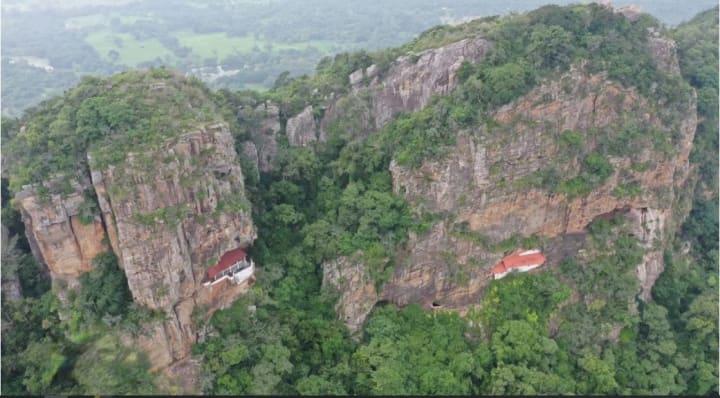
- Dolukanda

The mountain Dolukanda is located in the Kurunegala District, about 20 kilometers from the city of Kurunegala, near the Hiripitiya hamlet. It rises around 600 meters vertically from the flat plains. Its dimensions are around 2 kilometers long by 0.5 kilometers wide, with a forest reserve on top.
Folklore holds that the Rama-Rawana Legendary Battle served as the starting point for Dolukanda. Lord Rama and his brother Lakshman were both wounded by powerful arrows and knocked out during the battle between Ravana and Lord Rama. In order to preserve their lives, Lord Hanuman was charged with bringing them life-saving herbs from the Himalayas. Because he was unable to recognize the essential plants, he had to transplant a portion of the hill in Sri Lanka that he had previously brought back from India. It is stated that some of the hill's fragments fell on five Sri Lankan places when he was moving it; these areas are believed to be the cities of Dolukanda in the south, Rumasala in the north, Thalladi in Mannar, Ritigala in the east, and Kachchativu in the west. On the other hand, the top of Dolukanda is known as a herbal paradise since a variety of plant species with therapeutic potential may be found there.
Read : https://zeloan.blogspot.com/2022/10/dolukanda-in-sri-lanka.html
- Shrine of Our Lady of Madhu

A Roman Catholic Marian shrine named after Our Lady of the Rosary of Madhu is located in Sri Lanka's Mannar district. This shrine, which has a history spanning more than 400 years, serves as a place of devotion and pilgrimage for Sri Lankan Catholics. The location is well renowned as a center of devotion for both Tamil and Sinhalese Catholics and is regarded as the most sacred Catholic shrine on the island. The church has served as a symbol of harmony amongst people of many religious backgrounds, including Buddhists, Hindus, and Protestants, in addition to Tamils and Sinhalese.
On July 2, 1924, Pope Pius XI gave the picture of Our Lady of Madhu a canonical coronation. Before the start of the Sri Lankan Civil War, attendance at the August event occasionally reached up to a million people. Due to the presence of refugee camps close to the shrine complex and its location in the middle of a combat zone, the Civil War had a significant impact on pilgrimage to this site. It received many shelling.
Read : https://zeloan.blogspot.com/2022/08/shrine-of-our-lady-of-madhu-in-sri-lanka.html
- Ulpotha
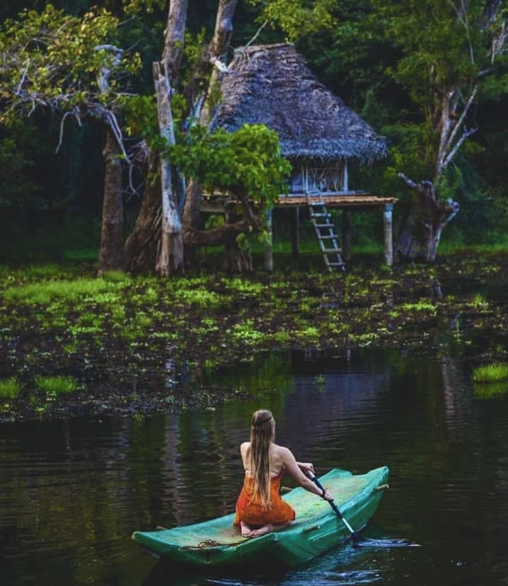
Few locations remain in the world where you may feel secure in the arms of nature while being free from the numerous worries and strains of contemporary life. Ulpotha is one such location. You find unfathomable natural beauty and tranquility at the foot of the Galgiriyawa mountain, on the edge of a lotus-ringed lake on one side and surrounded by emerald green paddy fields on the other.
Ulpotha was created without electricity, thus daytime rhythms govern daily life. Paths and lodging are lighted by lanterns and lamps, and the flickering glow of firelight evokes an enthralling and romantic feeling of bygone eras.
Visitors may enjoy the many pleasures and profound health benefits of connecting with nature since the lovely natural environment is everywhere in Ulpotha and is always there, present, and immediate in a way that is reassuringly secure and unthreatening.
Read : https://zeloan.blogspot.com/2022/09/Ulpotha.html
- Sri Nagala Raja Maha Viharaya
A highly beautiful site of worship, Sri Nagala Raja Maha Viharaya is situated in the Nikawewa region between Moragollagama and Madagalla. This temple, which is located at the base of a sizable hill, is believed to have been constructed during the reign of King Devanampiyatissa. Additionally, it is said that Prince Saliya, the son of King Dutugemunu, was in charge of much of the temple's subsequent works. This temple, which had been abandoned for a very long period, was eventually emptied out and made entirely sacrosanct.
Read : https://zeloan.blogspot.com/2022/11/nagala-raja-maha-viharaya-in-sri-lanka.html
Google Map:
About the Creator
Zeloan
I'm a Traveller, Blogger, and Content Creator. Visit Sri Lanka, and you can see the most beautiful places in the world and the remarkable hospitality here


Comments
There are no comments for this story
Be the first to respond and start the conversation.