World History
The Rise of Richard the Lionheart
If you've ever watched a movie, read a book, or played a game depicting medieval England, chances are you’ve encountered Richard the Lionheart. Crowned King of England on September 3, 1189, Richard I remains one of the most celebrated monarchs in English history. Though modern scholars have questioned some aspects of his legacy, his name still echoes in legends, stories, and films, cementing his status as a timeless figure in folklore and pop culture. Richard I, known as Richard Cœur de Lion (or Richard the Lionheart), was born on September 8, 1157, likely in a royal palace in Oxford. He was the third son of King Henry II of England and Eleanor of Aquitaine, a powerful and influential political figure of her time. Richard’s mother played a crucial role in his life, as she did in European politics, wielding immense influence due to her vast inheritance and her position as the former queen of France and the queen of England. Richard was one of five children, and he became his mother’s favorite, a preference that would shape his upbringing and career.
By A História2 years ago in History
How Did Hitler Rise to Power?
The rise of Adolf Hitler, a dictator responsible for one of the most horrific genocides in history, is a chilling narrative that began in the aftermath of World War I. Germany had fought valiantly, but the successful advance of the Allied forces in1918 made it clear that the war was unwinnable. Consequently, Germany signed an armistice, bringing an end to the fighting. As Germany’s imperial government crumbled, civil unrest and widespread worker strikes erupted throughout the nation.
By DANIEL AKAM OKO2 years ago in History
People Rebuilding Their Homes with the Earth: A Return to Sustainable Architecture
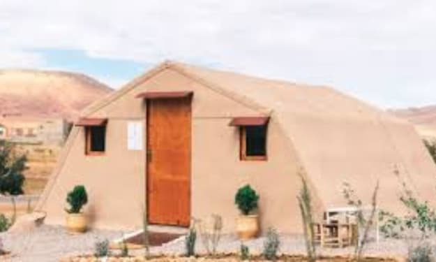
In an era where concrete jungles dominate the landscape, a quiet revolution is taking place. People across the globe are turning back to nature, literally, by rebuilding their homes using earth. This age-old practice, rooted in traditional techniques, is experiencing a resurgence as individuals seek sustainable, eco-friendly alternatives to modern construction. By embracing the earth as a building material, these people are not only helping the environment but also creating healthier and more resilient homes.
By Zinnat ara Begum2 years ago in History
The Sweet Track: A 5,830-Year-Old Window into Neolithic Ingenuity
Tucked away in the marshy Somerset Levels of southwest England lies one of the most remarkable archaeological discoveries of the 20th century: the Sweet Track. This ancient Neolithic timber walkway, unearthed in 1970, is not only a marvel of prehistoric engineering but also one of the oldest known wooden trackways in the world. Dating back an astonishing 5,830 years, the Sweet Track offers a glimpse into a time when humans were transitioning from nomadic lifestyles to more settled agricultural communities. It stands as a testament to the ingenuity and resourcefulness of our distant ancestors. The Discovery and Significance of the Sweet Track The Sweet Track was discovered by chance in 1970 during peat excavations in the Somerset Levels, a low-lying area known for its wetlands and bogs. Local archaeologist Ray Sweet, after whom the track is named, realized the significance of the timbers that had been exposed by the digging. Subsequent investigations revealed that these wooden planks and poles formed a long, continuous pathway stretching across the boggy landscape. Radiocarbon dating confirmed the remarkable age of the Sweet Track, pinpointing its construction to around 3807-3806 BC. This places the track in the Neolithic period, a time when the first farmers were cultivating crops and raising livestock in Britain. The discovery of the Sweet Track not only provided new insights into the technological abilities of Neolithic societies but also gave archaeologists a unique opportunity to study well-preserved organic material from this era, something rarely found in archaeological sites. A Dry Path Through the Wetlands The Somerset Levels, then as now, were a marshy, waterlogged landscape. For the Neolithic people living in the area, this made travel across the wetlands difficult and dangerous, especially during periods of heavy rain or flooding. The Sweet Track was part of a broader network of timber walkways built to provide a dry and stable path over the marshes, connecting settlements and facilitating movement across the landscape. The track itself was constructed using timber planks laid across wooden poles that had been driven into the soft ground. The builders used a variety of tree species, including oak, ash, lime, and hazel, to create a sturdy structure that could support the weight of people walking across the wetland. The craftsmanship involved in its construction is impressive, especially considering that Neolithic people lacked metal tools. Instead, they relied on stone axes to fell trees and shape the timbers. The Sweet Track extended for around 2 kilometers (1.2 miles), making it one of the longest known prehistoric timber trackways. Its careful construction and alignment suggest that the Neolithic builders had a good understanding of both the landscape and the materials they were working with, and they likely possessed significant knowledge of carpentry and engineering. Life in Neolithic Somerset The people who built and used the Sweet Track lived during a period of significant change in human history. The Neolithic, or New Stone Age, marked the transition from a hunter-gatherer lifestyle to one based on agriculture and permanent settlements. In Somerset, this shift would have been particularly challenging due to the region’s waterlogged environment, but the construction of trackways like the Sweet Track demonstrates that these early farmers were adapting to their surroundings in creative and innovative ways. Excavations around the track have uncovered a wealth of artifacts that provide clues about the daily lives of the people who used it. These finds include flint tools, pottery shards, wooden containers, and even plant remains, offering a snapshot of the types of resources and materials that were available to Neolithic communities in the Somerset Levels. The discovery of human footprints preserved in the peat near the track adds a poignant reminder of the individuals who once walked this ancient path. Interestingly, the Sweet Track was built directly on top of an earlier trackway, known as the Post Track, which suggests that the area had been an important route for some time. This raises intriguing questions about the role of these trackways in Neolithic society—were they purely functional, or did they hold some symbolic or ceremonial significance as well? Preservation in the Peat One of the reasons the Sweet Track has survived for nearly six millennia is the unique environment of the Somerset Levels. The waterlogged conditions of the peat bogs create an oxygen-poor environment that prevents the decay of organic materials like wood. As a result, the wooden timbers of the Sweet Track were exceptionally well-preserved when they were discovered, allowing archaeologists to study them in detail. Peat extraction, however, poses a significant threat to the preservation of the trackway. As the peat is removed and the water table drops, the once-protected timbers are exposed to air, causing them to dry out and decay rapidly. Efforts have been made to conserve sections of the Sweet Track, but much of it has already been lost to natural decay and human activity. The Legacy of the Sweet Track The discovery of the Sweet Track has provided invaluable insights into Neolithic technology, society, and the relationship between humans and their environment. It serves as a reminder of the ingenuity of our ancestors, who were able to overcome the challenges of their environment using the materials and tools available to them. Today, the Sweet Track is recognized as a significant piece of cultural heritage, not only for the people of Somerset but for the world. It stands as one of the earliest examples of large-scale human engineering and a testament to the resourcefulness of Neolithic societies. Though much of the trackway may now be hidden beneath the ground, its legacy endures, offering us a tangible connection to a distant past and a deeper understanding of the lives of the people who once walked its ancient planks.
By Deji Akomolafe2 years ago in History
The Ingenious "Snake Bridge" of the Macclesfield Canal: A Testament to 19th-Century Engineering
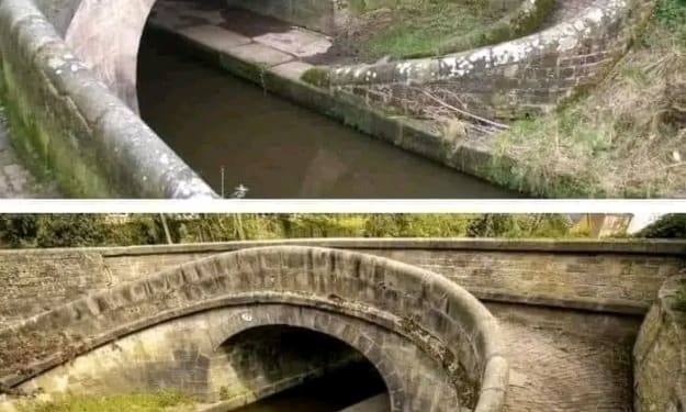
The Macclesfield Canal, which opened in 1831, played a crucial role in British industry during the 19th century, facilitating the transportation of goods and resources across northern England. A distinctive and innovative feature of this canal system is the "snake bridge," a clever engineering solution designed to allow horses to continue towing barges without the need to unhitch or interrupt their journey. These bridges are not only functional marvels of their time but also represent the ingenuity and adaptability of British canal engineering. In this blog post, we’ll explore the history and significance of the snake bridge, its unique design, and its role in the broader context of Britain’s industrial revolution and canal system development. The Origins of the Snake Bridge In the early 19th century, canals were the lifeblood of British industry. They provided an efficient way to transport heavy goods, such as coal, iron, and textiles, from factories and mines to markets across the country. Barges and narrowboats were commonly used to move these materials, and horses were the primary source of power for towing the boats along the canals. The towpaths that ran alongside the canals allowed horses to pull barges by means of long ropes, often with minimal effort, as the waterborne cargo moved relatively easily compared to road transport. However, canals often featured obstacles such as bridges, which created logistical challenges. When a bridge crossed a canal, it would typically be necessary to stop the boat, unhitch the horse from the towline, lead it across the bridge, and reattach it on the other side before resuming the journey. This process was time-consuming and labor-intensive, which became an issue as the demand for industrial transport increased. To address this problem, the snake bridge (also known as the "turnover bridge" or "roving bridge") was developed. This innovative design allowed horses to change sides of the canal without needing to be unhooked from the towline. The name "snake bridge" derives from the serpentine or spiral ramps that the horse would use to cross the canal, making a complete 360-degree turn in the process. This feature allowed the towline to remain attached to the barge, thus avoiding the time-consuming process of stopping and re-harnessing the horse. The Design and Functionality of the Snake Bridge The snake bridge is a clever example of how engineering can solve practical problems in transportation. Its defining feature is the spiral or curved ramps that allow the horse to cross over the canal while maintaining its forward momentum. These ramps are carefully designed to enable the horse to make a gradual, smooth turn as it crosses the bridge, effectively reversing its direction while remaining connected to the towline. The towline itself would pass through a slot or gap in the bridge’s parapet, allowing it to follow the boat on the water as the horse crossed overhead. By maintaining the towline's connection, the horse could continue towing the boat seamlessly, with no interruption to the journey. The construction materials of snake bridges varied depending on the location and availability of resources. Many of the bridges along the Macclesfield Canal were made from stone or brick, with some incorporating cast iron components. The ramps were often paved with alternating rows of protruding bricks, designed to give the horse’s hooves traction and prevent slipping, especially in wet weather conditions. This detail is a testament to the thoughtfulness and attention to practical needs in the bridge’s design. The Importance of the Snake Bridge in Industrial Transport The development of the snake bridge was a significant innovation for the canal system, particularly in a time when speed and efficiency were paramount for industrial transport. The British industrial revolution relied heavily on the movement of raw materials like coal, iron, and textiles, and canals were the most reliable means of moving such bulky and heavy loads before the advent of railways. By eliminating the need to stop and unhitch horses every time a bridge was encountered, snake bridges increased the efficiency of canal transport. Boats could continue their journey uninterrupted, reducing delays and allowing goods to be delivered more quickly and reliably. In this way, the snake bridge helped to streamline the logistics of canal-based transportation, contributing to the broader success of Britain’s industrial economy. Furthermore, the design of the snake bridge exemplifies the problem-solving mindset of 19th-century engineers. Faced with a practical challenge, they devised a solution that was not only functional but also elegant in its simplicity. The bridges are a testament to the creativity and ingenuity that characterized the era of canal building in Britain. The Legacy of the Macclesfield Canal and Its Snake Bridges The Macclesfield Canal, completed in 1831, is one of the last narrow-gauge canals built in England before the rise of the railway system. At 26 miles long, it connects Marple, in Greater Manchester, to Hall Green, near Kidsgrove in Staffordshire. It was a crucial link in the network of canals that crisscrossed northern England, providing access to major industrial cities like Manchester, Stoke-on-Trent, and Birmingham. Although railways eventually supplanted canals as the primary mode of industrial transport, the Macclesfield Canal and its snake bridges remain an enduring symbol of Britain’s canal-building heritage. Today, the canal is a popular destination for leisure boating and walking, with many visitors coming to admire the unique engineering features, including the iconic snake bridges. Several of these bridges still exist along the canal, their stone and brickwork a reminder of the practical genius of their designers. The Macclesfield Canal has been preserved as a historical and recreational waterway, and the snake bridges continue to be admired for their functionality and aesthetic appeal. In a sense, they are living monuments to the ingenuity of a bygone era when horses and barges were the backbone of British industry. Conclusion The snake bridges of the Macclesfield Canal stand as remarkable examples of 19th-century engineering, embodying the practical, problem-solving spirit that defined Britain’s industrial revolution. By allowing horses to cross the canal without interrupting their tow, these bridges improved the efficiency of canal transport, saving time and effort for the workers and animals involved. Though simple in concept, the snake bridge design reflects the brilliance of canal engineers who understood the importance of small innovations in improving the overall functioning of the canal system. Today, these bridges remain an enduring part of Britain’s industrial heritage, appreciated by historians, engineers, and tourists alike for their clever design and historical significance. As we look back on the role of canals in shaping the industrial landscape of Britain, the snake bridge serves as a reminder of how thoughtful, practical engineering can have a lasting impact on transportation and infrastructure.
By Deji Akomolafe2 years ago in History
The Fosse Way and the A303: Unearthing England’s Ancient Roman Road
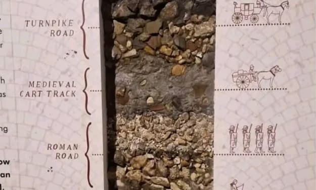
In the English countryside, beneath the busy modern lanes of the A303 highway, lies a hidden historical treasure—an ancient Roman road known as the Fosse Way. This road, which has existed for nearly two millennia, traces a route that once connected the southwest of England to the heart of Roman Britain. Though buried beneath layers of modern infrastructure, cross-sections of the ground beneath the A303 reveal the path of this remarkable Roman road, providing a glimpse into a world that existed thousands of years ago. The Fosse Way is not just a relic of the Roman occupation; it is a testament to the enduring significance of this route, which has remained a central artery of human activity since long before the Roman Empire laid its first stone. The proximity of this road to Stonehenge, one of the most famous prehistoric monuments in the world, highlights the historical depth of the area, where human activity has spanned from the Iron Age and possibly even earlier. In this blog post, we will explore the historical importance of the Fosse Way, its connection to the Roman Empire, and how its path intersects with some of England’s most iconic ancient landmarks, such as Stonehenge. We will also consider how this ancient route continues to influence modern infrastructure and the cultural landscape of England today. The Fosse Way: A Roman Legacy The Fosse Way was one of the principal Roman roads built in Britain following the Roman invasion in AD 43. The word “Fosse” comes from the Latin fossa, meaning ditch, as it is believed the road may have originally been flanked by defensive ditches. Stretching from Exeter (Isca Dumnoniorum) in the southwest to Lincoln (Lindum Colonia) in the northeast, the Fosse Way spanned nearly 200 miles and served as a crucial military and trade route for the Romans. This road was part of a larger network of Roman roads that crisscrossed Britain, facilitating the movement of troops, goods, and information across the occupied territory. Roman engineers, renowned for their road-building prowess, constructed the Fosse Way to be as straight as possible, adhering to a direct route that cut across the varied landscape of southern and central England. The Fosse Way’s straightness is one of its most striking features, even today. Unlike modern roads, which often follow the contours of the land, Roman roads were built with military efficiency in mind. The Romans were less concerned with the challenges posed by the terrain and more focused on creating the shortest and fastest route between two points. This meant cutting through hills, building bridges over rivers, and laying down a solid foundation of stone, gravel, and sand to ensure durability. A Road Through History The significance of the Fosse Way extends far beyond its function as a Roman road. The route it follows was likely in use long before the Romans arrived, serving as a pathway for ancient Britons during the Iron Age. The road passes through or near several key historical sites, including Stonehenge, the famous prehistoric stone circle that dates back over 4,000 years. The proximity of the Fosse Way to Stonehenge suggests that this area has been a hub of human activity for millennia. Stonehenge itself, with its mysterious origins and alignment with the solstices, was a place of ceremonial and astronomical significance for the ancient peoples of Britain. The surrounding landscape is dotted with burial mounds, earthworks, and other archaeological remnants of early societies, further underscoring the importance of this region as a crossroads of human history. By the time the Romans arrived in Britain in the 1st century AD, they encountered a land already rich in culture and history. The Fosse Way allowed the Romans to establish a firm foothold in this new territory, but it also connected them with the ancient traditions and landmarks of the British Isles. As the Romans built their cities, forts, and roads, they layered their own history over that of the ancient Britons, creating a complex tapestry of human civilization that remains visible today. The Fosse Way and Stonehenge: A Unique Intersection One of the most fascinating aspects of the Fosse Way is its proximity to Stonehenge. While the Roman road does not pass directly through the monument, it runs close enough to provide a tantalizing connection between these two significant historical sites. Stonehenge, a UNESCO World Heritage site, is one of the most iconic prehistoric structures in the world, and its location near the Fosse Way raises interesting questions about the relationship between these two landmarks. Did the Romans know about Stonehenge? While there is no definitive evidence that the Romans paid special attention to Stonehenge, it is highly likely that they were aware of its existence. Stonehenge would have already been an ancient monument by the time the Romans arrived, and given their appreciation for monumental architecture, they may have seen it as a curiosity, if not a place of religious or cultural significance. It is also possible that the Fosse Way itself was aligned with older, prehistoric tracks that had been in use for centuries. The road’s straightness and its alignment with key natural and man-made landmarks suggest that the Romans may have been following routes established long before their arrival. In this way, the Fosse Way serves as a bridge between the prehistoric past and the Roman period, linking two of the most significant epochs in British history. The A303: A Modern Highway With Ancient Roots Today, the A303 highway runs roughly parallel to the route of the Fosse Way, with parts of the modern road built directly over the ancient Roman road. The A303 is a major thoroughfare connecting the southwest of England to London, and it remains one of the most heavily trafficked roads in the region. However, beneath the asphalt and concrete, the legacy of the Fosse Way endures. The modern road system owes much to the Roman road network, which laid the groundwork for the development of infrastructure in Britain and across Europe. Roman roads were so well-built that many of them continued to be used for centuries after the fall of the Roman Empire, and their influence can still be seen in the layout of modern roads and highways. The A303 is a prime example of this enduring legacy. In places where the modern road deviates from the path of the Fosse Way, archaeologists have found cross-sections of the ancient Roman road beneath the surface, revealing the stone foundations that have remained intact for nearly 2,000 years. These discoveries provide a tangible link between the past and the present, reminding us that even as we travel along modern roads, we are often following in the footsteps of those who came before us. Conclusion: The Fosse Way’s Enduring Legacy The Fosse Way is more than just an ancient Roman road—it is a pathway through history, connecting the modern world with the ancient past. From its role as a critical Roman military route to its connection with prehistoric landmarks like Stonehenge, the Fosse Way has been at the center of human activity in Britain for thousands of years. Today, as drivers travel along the A303, they are unknowingly following the route of the Fosse Way, retracing the steps of Roman soldiers, traders, and travelers who once walked this road. Beneath the modern highway lies the hidden story of an ancient civilization, preserved in the layers of earth that have accumulated over centuries. The Fosse Way’s enduring presence beneath the A303 serves as a reminder of the deep and complex history that lies beneath the surface of the land we live on. It is a testament to the skill and foresight of the Roman engineers who built it, as well as to the countless generations of people who have traveled along this route, leaving their own marks on the landscape of Britain.
By Deji Akomolafe2 years ago in History
The White Horse of Uffington: A 3,000-Year-Old Enigma
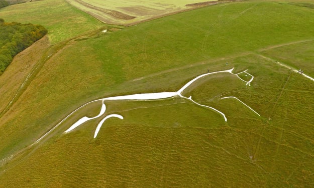
Perched on the rolling chalk hills of Oxfordshire, England, the White Horse of Uffington has captured the imagination of locals and historians alike for over 3,000 years. This iconic hill figure, carved into the earth, stands as a remarkable testament to the creativity and ingenuity of prehistoric peoples. Yet, for all its grandeur and historical significance, much about the White Horse remains shrouded in mystery. Who created it? Why was it made? And what does it truly represent? In this blog post, we’ll explore the fascinating history of the White Horse of Uffington, delve into its possible meanings, and examine why this ancient symbol continues to captivate us today. A Monument to Time: The Creation of the White Horse The White Horse of Uffington is a striking figure that measures approximately 360 feet in length. It was created by carving deep trenches into the chalk hillside and then filling them with crushed white chalk, which forms the sleek, almost abstract image of a horse. This process has left an enduring mark on the landscape that can be seen for miles around, its brilliant white outline standing out vividly against the surrounding greenery. Dating the White Horse has been a matter of some debate among archaeologists. For years, it was assumed that the figure might be a relatively recent creation, perhaps from the Saxon or medieval periods. However, scientific dating techniques have now shown that the figure dates back to at least 1000 BC, placing it firmly in the late Bronze Age or early Iron Age. This makes the White Horse of Uffington one of the oldest hill figures in Britain. What’s more remarkable is that the figure has been maintained continuously for over 3,000 years. Generations of locals have taken it upon themselves to "scour" the horse, a process involving cleaning and refilling the trenches with fresh chalk to ensure that the figure remains visible. This tradition, which continues to this day, speaks to the enduring cultural significance of the White Horse to the people of Oxfordshire. The Mystery of Its Meaning Despite its age and prominence, the true purpose and meaning of the White Horse of Uffington remain largely speculative. The figure is so stylized that it doesn’t resemble a horse in a traditional sense; its long, flowing curves and elongated body give it an almost ethereal, abstract quality. This has led some researchers to suggest that it may not represent a horse at all, but perhaps a dragon or another mythical creature. Others argue that it is indeed a horse, given that horses held significant symbolic and practical importance in prehistoric Britain. One prevailing theory is that the White Horse was a symbol of power and fertility, perhaps connected to a local deity or tribal chief. Horses were associated with the elite in Bronze Age society, and their strength and speed made them valuable both in warfare and in agriculture. The figure may have been a sacred symbol, intended to assert dominance over the land and invoke protection from the gods. Another interpretation links the figure to the ancient Celtic goddess Epona, who was revered as the protector of horses, riders, and fertility. It’s possible that the White Horse was a tribute to her, a way of honoring the divine through this massive hill carving. While there is no definitive evidence to support this theory, the idea of the figure being tied to ancient religious practices remains an intriguing possibility. Alternatively, the White Horse may have been created for more practical purposes. Some archaeologists suggest that the figure could have served as a territorial marker, signaling the boundaries of a particular tribe’s land. Visible from afar, the White Horse would have been a bold statement of ownership and identity. A Link to the Ancient Past The landscape around the White Horse of Uffington is rich in archaeological significance, with several other ancient monuments located nearby. Close to the hill figure is Uffington Castle, an Iron Age hillfort that dates back to the same period as the horse. This suggests that the area was of considerable importance during the prehistoric era. The hillfort’s commanding position on the high ground, overlooking the horse, reinforces the notion that the figure was a significant part of the local cultural landscape. Also nearby is the Neolithic long barrow known as Wayland's Smithy, a burial site that predates the White Horse by several thousand years. According to legend, Wayland's Smithy was the home of Wayland, a mythical blacksmith associated with magic and metalworking. Folklore has it that if you leave your horse tied up at the site overnight, along with a coin for payment, Wayland will shoe the horse by morning. This rich blend of history and myth highlights the area's deep connection to ancient traditions and beliefs. The Legacy of the White Horse Today, the White Horse of Uffington remains a beloved cultural symbol, attracting tourists, history enthusiasts, and artists. Its striking simplicity and ancient origins make it an enduring icon of the English countryside. The horse has been featured in literature, art, and even on local emblems, serving as a symbol of continuity between the modern world and the distant past. The annual scouring festival, where locals gather to clean and maintain the horse, is a reminder that this figure is not just a relic of the past—it’s a living part of the community’s heritage. By participating in this tradition, each generation contributes to the preservation of the White Horse, ensuring that it remains a visible link to the ancestors who first carved it into the earth. Conclusion The White Horse of Uffington is a truly remarkable artifact of Britain’s prehistoric past. Its enigmatic form, its connection to ancient rituals and mythology, and its lasting presence on the landscape make it one of the most intriguing hill figures in the world. Though much about its origin and purpose remains a mystery, what is certain is that the White Horse continues to inspire awe and fascination, just as it has for millennia. Whether it was created as a religious symbol, a territorial marker, or something else entirely, the White Horse stands as a powerful reminder of the creativity and ingenuity of our distant ancestors. Its enduring presence on the chalk hills of Oxfordshire invites us to reflect on the past and to ponder the mysteries of those who came before us.
By Deji Akomolafe2 years ago in History
The Fascinating History of Cemeteries
When we think of cemeteries, images of spindly trees, rusted gates, crumbling stones, and solitary mourners often come to mind. However, it wasn’t long ago that many burial grounds were vibrant places, filled with blooming gardens and crowds of people strolling among the headstones. How did cemeteries transform into the solemn spaces we recognize today?
By DANIEL AKAM OKO2 years ago in History