

The world shapes our maps, right? Or to put it more simply, our maps depict the world around us as we see it. Because, as John Green points out in his TedTalk, my map of New York and your map of New York will likely look very similar due to the shape of New York. Therefore, all the maps of New York will also be mostly identical. That much seems obvious, right?
But enough of New York, because this is not always the case. Once, serendipitously, the way we drew a map actually did shape the world.
In a world filled with real-life wonders and breathtaking destinations, I have an unusual obsession (trust me - people have told me so, repeatedly) – places that exist on maps but don't actually exist in reality. I was drawn in by one story in particular.
In the early 1900s, as the Wright Brothers dared to fly, Otto G. Lindberg's General Drafting Corporation took a huge risk and began to produce cheap, foldable driving maps. America’s two biggest corporate map makers, Rand McNally and H. M. Gousha initially ignored what they believed would be a fleeting style and a risky business venture. This allowed General Drafting to dominate the market. But by the 1930s, both corporate giants had realized their mistake and raced fiercely to catch up.
Lindberg and his assistant, Ernest Alpers, were concerned that because there would be no way to prove if any rival looking to cut corners could simply copy and replicate General Drafting's hard work instead of conducting their own land surveys. Lindberg and Alpers had far less money, manpower, and industry clout and so they decided to insert a fake town into their map of New York. They called it Agloe, a combination of both their names: Ernest Alpers (EA) and Otto G. Lindberg (OGL). And thus, America’s first phantom settlement was born.
“By including this fictitious paper town on their map, they could catch anyone who copied their work. This revelation fascinated me, as it highlighted the intricacies of copyright law and the lengths some cartographers would go to protect their intellectual property,” writes author and travel enthusiast Samuel Fisher in an email to me.
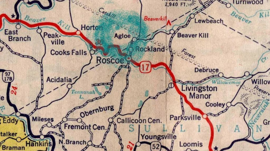
Located in the Catskills, nestled in a remote area north of Roscoe and (quite frankly) in the middle of nowhere, Lindberg and Alpers placed their phantom settlement, their paper town, and the ultimate copyright trap. You see, if any of their competitors copied General Drafting’s maps, it would be easy to tell because the fake town of Agloe would also be depicted.
Some time after General Drafting published its New York State driving map with their secret town hidden on it, the mapping corporation Rand McNally released its own version, and Lindberg spotted Agloe on their competitor's map in the exact same area. Lindberg believed that he’d caught Rand McNally redhanded for copyright infringement. And they basically said, “We’re gonna sue you for all you’ve got!” Agloe was completely made up, Lindberg declared, it wasn't real.
Except it was, said Rand McNally.
Lindberg and his lawyers drove out to the deserted Catskills countryside where they’d placed Agloe on his map, ready to claim victory.
He was stunned by what he found.
Right where there should have been nothing at all was a gas station, a general store, and even houses with people living in them. In other words, a totally made-up town that was not supposed to exist somehow mysteriously did.
I, alongside so many others, have been fascinated by the story of Agloe, New York. The captivating storyline of an “impossible town,” as Peng Shepherd calls it in her bestselling novel, The Cartographers, “[is] a real-world mystery of an imaginary town that became real was too tantalizing to let go.” Fisher agrees saying, “I have always been drawn to incorporating fictional places like phantom settlements in my stories. They offer a sense of mystery and intrigue, allowing readers to explore the boundaries between reality and imagination.” Shepherd’s novel boldly explores blurring the boundaries between the two, based on the true story of Agloe, New York. And of course, we could never forget that Agloe inspired John Green to write his internationally bestselling novel, Paper Towns.
Imagination really did become reality. As Shepherd writes, “The truth of what happened is just as fascinating as any fiction.” It turns out that when General Drafting's map was first released to the residents of the area where Lindberg and Alpers had planted Agloe, they saw this new name on the map and assumed someone “established” the new town for them. Thus, new businesses and houses added Agloe to their addresses. This then prompted county administrators to record the information into an official record in Delaware County administration logs. So by the time Rand McNally’s cartographers traveled through to survey the area, the locals confidently told them that this little town was indeed called Agloe.
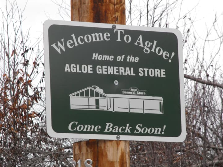
Since then, phantom settlements have been used multiple different times by various different entities, but none attained the widespread attention that Agloe generated. Agloe became somewhat of a tourist destination, even as the general store and the surrounding buildings are otherwise abandoned. Łukasz Koszyk, a travel enthusiast and DBD of a travel company tells me, “The story of Agloe serves as a reminder that sometimes the journey and the tales behind a place are more significant than the destination itself.”
Sometimes the journey and the tales behind a place are more significant than the destination itself.
“Copyright traps on maps are unfortunately a thing of the past these days. [It’s] because there are publicly-available map datasets like OpenStreetMap, and most modern maps are not copyrighted; instead, the interface, products, and services around them are,” says Ben Michael, Attorney, and Copyright Law Expert in response to my query on modern copyright traps
Alas, this is true but that does not necessarily mean the 21st century has been devoid of mapping scandals.
“Map companies will copyright their app, or their atlas, or their creative interpretation of available data, rather than the map information itself. Google maps actually had a problem with this when they first launched, though. Their original map data was licensed from a database of copyrighted maps, and there were still fake locations, as late as 2010,” says Michael.
Other notable examples include Argleton in Lancashire, UK (removed from Google Maps in 2010) and Moat Lane in London (also removed in 2010).

Nevertheless, I am still fascinated by what Algoe achieved. If you think back to the idea that the world shapes our maps - Lindberg, Alpers, and their little town achieved something far more spectacular, even if it was by serendipity. General Drafting’s Map of New York, somehow, magically, made part of the world real. The story of Agloe proves how maps, even in the 21st century, can still hold secrets and extraordinary stories.
And that seems pretty magical to me.
About the Creator
Pickleball Politics: Behind the Exponential Rise of the Sport That Conquered the World
Back in 2017, I joined an interesting summer club - pickleball and chess. Three years earlier my family and I had moved from New Jersey to the suburbs of North Carolina. Prior to that move, I had never heard of pickleball before, although I learned quickly enough - North Carolinians were crazy about it.
By Aiden about a year ago in Unbalanced
The Snake-Worshipping, Fur-Wearing Woman Who Made Alexander Great
What do you know about the mother of Alexander the Great? It's not a trick question. The woman who gave birth to one of history's military greats has been much obscured by the long, dark shadow of history. Short of a few awkward caricatures in film, little has been brought into focus about the infamous Olympias of Molossia.
By E.B. Johnson 20 days ago in History
Caesar Rise and Fall
Julius Caesar was born in 100 BC into a patrician family in Rome. He quickly distinguished himself through his military and political talents. Caesar's early career was marked by his association with powerful figures such as Crassus and Pompey, who helped him secure key political positions. As a young man, he served in various capacities, gaining both military experience and political acumen.
By Hưng Trần Giaabout 8 hours ago in History


Comments
There are no comments for this story
Be the first to respond and start the conversation.