

***** Good news! Snice this research was first done while I was a graduate student the city of Detroit has shut down the polluting WTE plant. *****
INTRODUCTION AND BACKGROUND
This work based on the research done throughout the semester during my capstone project. My capstone team are worked with Bloomberg Associates and the City of Detroit to help the city understand and mitigate the impacts of their Waste to Energy (WTE) plant.
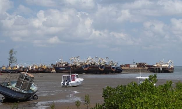
The Detroit Renewable Power (DRP) waste to energy (WTE) facility has, since it was opened in 1989, presented significant nuisance concerns to residents in Detroit. The DRP facility produces up to 68 megawatts of electricity and creates steam to heat for more than 140 commercial and private customers on the Detroit steam loop. The facility was currently owned by DRP, a privately held company, regulated by Michigan Department of Environmental Quality (MDEQ) until the City of Detroit shut the incinerate down in 2019.
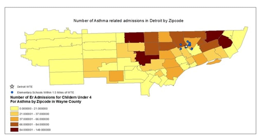
Although many cities with a WTE plants faces challenges managing emissions, the emissions the WTE plant in Detroit are environmental injustice. People of color comprise 87% of the population within one mile of the DRP facility, with 60% living below the national poverty line and 20% unemployed. The plant is in a densely populated urban area and the children downwind of the plant are three times more likely to be hospitalized for asthma than other Detroiters. That statistic is particularly striking considering that the Detroit metropolitan area has the fifth highest rate of asthma-related deaths in the US. Keep in mind that Detroit is only the 23rd most populous city. The children attending the schools within 1.5 miles of the DRP facility one of which is just across the highway are particularly vulnerable.
The goal of this work is to create maps that will help Detroit quickly see the pollution levels from incinerators generally and will highlight that the impact for people living near Detroit’s incinerator. The objectives are to show the incidence of asthma in children in the zip codes near the incinerator, illustrate the number of elementary schools which are in proximity of the incinerator, and situate the level of pollution from Detroit’s WTE plant compared to WTE plants in other densely populated urban centers in the US.
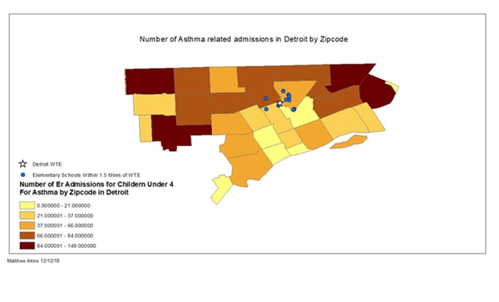
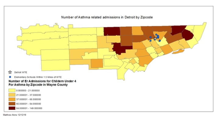
Analysis with GIS map was able to show that there is a striking difference between the number of ER admissions related to asthma in the city of Detroit, vs Wayne county outside of the city limits. It is expected that there may be a somewhat higher number of asthma related ER admission in Detroit proper because it is densely populated, but the significantly high number of ER admissions related to Asthma in Detroit zip codes indicates that local pollutants from point emitters, like the DRP waste to energy plant (WTE) are creating adverse health impacts for children near by. As the map shows below there are 11 elementary schools with a 1.5 miles radius of the incinerator. The closest is practically just across the street.
If you are interested in how the maps were made please see my other article how to use GIS to show environmental injustice.
The maps also illustrate the important affects of wind coming off the lake. The wind blows to the North or West roughly 80% of the time. As such the zipcodes to the south east of the WTE plant, even the zipcode adjacent to it have relatively low asthma related ER admissions for children under four.
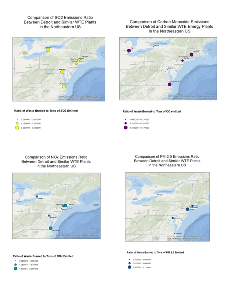
The following maps use graduated symbols to illustrate the amount pollutant emitted as ratio of tones of pollutant emitted to tons of waste burned. The maps quickly show how Detroit compares to other cities. For fine soot (PM 2.5), Sulfur Dioxide, and Nitrogen Oxides Detroit preforms relatively well when compared to comparable US WTEs. Unfortunately for Carbon Monoxide emissions Detroit is one of the worst offenders. The is a particularly bad category for Detroit’s WTE to struggle with because high levels Carbon Monoxide emission indicate incomplete combustion which allows toxics heavy metals like, lead, mercury, and arsenic to be released into the atmosphere.
1. OBSTACLES / ISSUES / LIMITATIONS
One of the largest potential issues with this work was that it relied on reported asthma related ER admissions of children under 4 as proxy for the severity of asthma problems in the zip codes around the incinerator. This indicator was chosen because it represents the frequency of acute life-threatening asthma related incidences in children under four in Wayne county. The issue is that this indicator can be inflated to causes completely unrelated to the WTE plants, such as lack of access to primary health care.
The second issue is that there are many large point emitters in the city of Detroit, although there appears to be higher incidence of ER related asthma admissions down wind of the WTE it is impossible to isolate the effects of the pollutants coming out of the flue from the WTE plants and pollutants coming out of the smoke stakes from other incinerators.
About the Creator
Streets Of The Blade Runners
Fog blanketed the city like a shroud, the cold mist clinging to everything in sight. The rain had long since stopped, but the streets were still slick with moisture, reflecting the neon lights of Blade Runner. The city that never slept was even quieter tonight, a fitting atmosphere for Malcolm Hammer’s line of work. He sat in the dim light of his cluttered office, the scent of stale cigarettes and old books filling the air. His desk was covered in files, each one a testament to the mysteries he’d solved over the years. But today, something different awaited him. A single letter, addressed in a feminine handwriting, lay atop the pile. As Malcolm Hammer, Private Eye, reached for the letter, he knew his life was about to change.
By Victor Robinson II7 days ago in Futurism


Comments
There are no comments for this story
Be the first to respond and start the conversation.