
Point Clouds From 3D Scanning to 3D Models
All You know About

Point cloud to 3D modeling process has completely transformed the way documentation, renovation, and management of built environment functions.
With the potential of 3D laser scanning technology and Point cloud data, it has become easier for surveyors and architectural organizations to carry on their surveys, take accurate measurements, and analyze the facility.
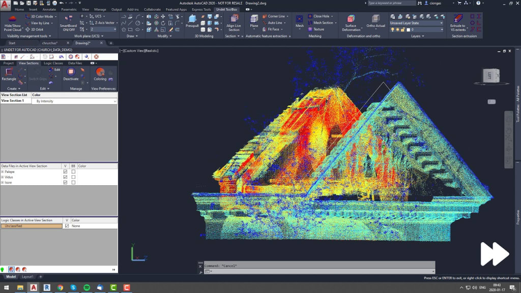
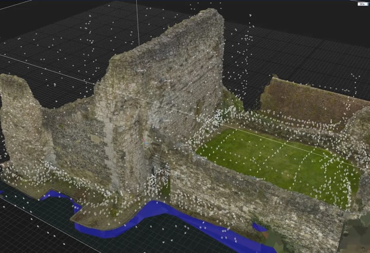
Point cloud data helps in resolving critical issues by offering precise geometry of the physical assets and as-built conditions of the existing facility. Point cloud data plays a crucial role when it comes to fields like heritage documentation, heritage renovation, and historical conservation.
Traditional surveying methods often fall short when it comes to accurately capturing the intricate details and complex forms of heritage sites. This leads to spatial inaccuracies, and errors, and hampers the essence of the structure.
Due to its subtle and non-intrusive nature, point cloud conversion of laser-scanned data precisely captures every detail, even from the most compact or hazardous areas where manual data collection won't be possible. This prominently reduces the surveying time, ensures safety, and provides accurate project outcomes.
What is Point Cloud?
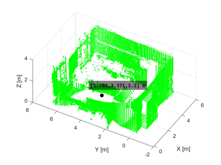
A point cloud is a set of data points in a three-dimensional coordinate system. These data points precisely represent the external surface of an object or a scene. A point cloud contains X, Y, and Z coordinates of every solid and visible surface of the project site.
Point Cloud data deliverables can be delivered in various file formats. 3D laser scanners produce raw data in multiple formats concerning the exporting capabilities of each software. Some of the formats are, .PTG , .E57, .RCS and. RCP format.
Point cloud data for construction and architecture enhances efficiency, accuracy and collaboration throughout the lifecycle of the project. From planning to designing to execution point cloud data have various applications namely
- As-built Documentation
- Site Planning and Visualization
- Quality Control and Inspection
- Safety Analysis
How is Point Cloud Data Obtained?
A point cloud data is obtained through various techniques like,
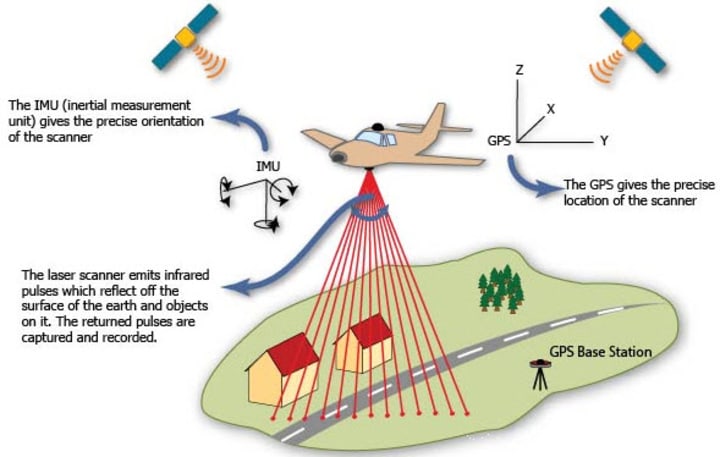
3D laser scanning: This involves emitting laser beams onto surfaces and measuring the distance to each point where the laser beam is reflected. This process generates a dense set of points, which accurately replicates the geometry of the scanned surface.
LiDAR: Light Detection and Ranging is a remote sensing technology. LiDAR uses laser beams to measure the time it takes for the light to return after hitting an object. This captured data is used to create immensely precise and detailed point clouds. LiDAR is hence a popular choice for capturing terrain, vegetation, and urban environments.
Photogrammetry: Photogrammetry is a technique for reconstructing 3D objects or settings using a series of overlapping pictures. Photogrammetry algorithms can compute the position and orientation of each camera, as well as the 3D coordinates of points on the object's surface, by evaluating the common features apparent in many photos. Photogrammetry is commonly utilized in archaeology, geology, and cultural heritage conservation.
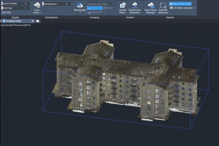
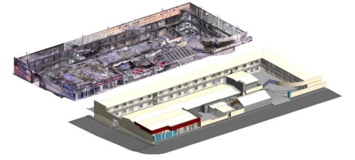
What is Point Cloud Conversion to BIM?
Point Cloud Conversion to Building Information Modeling (BIM) process typically involves translating the raw point cloud data that has been captured from the project site via 3D laser scanning service, into a comprehensive and structured 3D BIM model.
Advanced 3D laser scanning equipment captures millions of points that represent the physical assets of the scanned environment. This data is then cleaned and transferred for further processing.
The process of converting point cloud data to BIM involves the following steps:
Data Acquisition: This step consists of capturing point cloud data of the building or structure using 3D laser scanning technology. A comprehensive coverage and high-density point cloud acquisition should be ensured during this step.
Pre-processing: This step involves filtering, registration, and data normalization to enhance data accuracy and completeness. The raw point cloud data gathered is cleaned by removing inconsistencies, outliers, and noise.
Feature Extraction: Here, algorithms and software tools are used to identify and segment key features like walls, floors, columns, etc from the point cloud data. The algorithm recognizes the geometry of the features and extracts the relevant ones.
Geometry Reconstruction: In this step, the geometric primitives are fitted to the extracted features to create the representation of built geometry through curve-fitting and surface reconstruction.
BIM Object Creation: In this step, extracted features are converted into BIM objects and are integrated with metadata i.e. material properties, dimensions, etc
Model Integration: The BIM objects are then integrated into BIM software platforms like AutoDesk Revit, and Trimble Tekla to craft a BIM model.
Validation and Quality Assurance: In this step, the BIM model is validated against the original points cloud data to ensure accuracy and quality assurance. This is done to verify compliance with project requirements and industry standards.
What are the challenges faced during the conversion of Point Cloud data to BIM?
Various challenges can arise during the conversion of point cloud data to BIM, some of them are mentioned below.
- Data Quality and Accuracy.
- Complexity of Data
- Manual Intervention
- Interoperability and Compatibility
- Data Standardization
- Resource Constraints
- Expertise Requirements
Addressing and resolving these challenges calls for a combination of advanced technologies, skilled human intervention, etc. To ensure the accurate and efficient conversion of Scan to BIM, selecting the right scanning technology is of utmost importance.
How do 3D laser scanning services ensure accuracy in point cloud data?
With the latest equipment, advanced technology, and skilled workforce, 3D laser scanning can deliver accurate survey measurements, that can achieve a Scan to BIM model at up to LOD 500. 3D laser scanning services offer a myriad of benefits for architects, designers, and surveyors when it comes to the Scan to BIM process. Some of the benefits are listed below,
High-Resolution Scanning:
3D laser scanning technology captures a million points per second and achieves the approximate precision of 4-6 mm resulting in highly detailed and accurate point cloud datasets.
Advanced Precise Equipment:
Advanced 3D laser scanners are well equipped. They possess high-precision sensors and optics that ensure precise measurements during scanning.
Integration with Survey Control:
3D laser scanning technology can be integrated with legacy survey control methods, i.e. GPS to improve accuracy through georeferencing and control point registration.
Quality Assurance Check:
3D scanning service providers conduct quality assurance checks to verify the integrity of the point cloud data. Quality checks ensure that the acquired data meets industry standards and client requirements.
Expertise and Experience:
3D laser scanning service providers with skilled and experienced operators and technicians contribute to the accuracy and reliability of the point cloud deliverables.
What are the best practices for obtaining the ideal Point Cloud to 3D BIM modeling?
A few tips to ensure that the acquired data and the crafted model yield optimal results in the form of the highest accuracy, impeccable visualization, and reduced operation time.
Define the areas to be scanned and determine the level of detail that is desired according to the client's requirements.
- Invest in high-quality laser scanners for accurate data capture.
- Avoid and minimize environmental factors like lighting and weather conditions that can affect scan quality.
- Capture multiple scans from different viewpoints to ensure complete coverage of the site.
- Use reference points or GPS to facilitate the alignment of scans during post-production.
- Balance the level of detail and processing time by adjusting the point cloud density.
- Import the point cloud into BIM software like Autodesk Revit and use it as a basis for creating accurate 3D models.
How does outsourcing the point cloud to BIM requirements help architects, contractors, and surveyors?
Outsourcing the point cloud to BIM requirements to specialized companies has several benefits. This includes:
- Ensuring quality assurance for all the project typologies.
- Assuring Cost and Time efficiency.
- Facilitating quick decision-making.
- Minimizing errors with data acquisition
- Avoiding risks associated with on-site operations
- Enhancing sustainability
- Promoting reliable and transparent communication.
In conclusion, point clouds play an important role in bridging the gap between 3D scanning technologies and the creation of realistic 3D building information models.
Understanding the transition from 3D scanning to 3D BIM emphasizes the critical role of point clouds in optimizing workflows, improving collaboration, and driving innovation across industries.
About the Creator
Matt Sharon
A professional content writer. Having years of experience in Technology, health, finance, and construction and real estate field. Writing is my passion and I love to play with words Confidently.
Enjoyed the story? Support the Creator.
Subscribe for free to receive all their stories in your feed. You could also pledge your support or give them a one-off tip, letting them know you appreciate their work.
Keep reading
More stories from Matt Sharon and writers in Education and other communities.
Building Like Nature: Exploring Biomimicry in Architecture
Have you ever looked at a spiderweb and marveled at its strength? Or admired the way a termite mound maintains a cool temperature even on scorching days? These wonders of nature hold valuable lessons for human design, and that's where biomimicry comes in.
By Matt Sharonabout a month ago in Education
World of Finance: Understanding Its Dynamics and Significance
Finance, a cornerstone of economic systems, encompasses the management of money, investments, and financial instruments. This exploration aims to demystify the essence of finance, elucidate its paramount importance in global economies, and emphasize the role of assignment help in guiding students through the intricacies of finance coursework. Assignment Helper underscores the academic support available for students studying finance and the interconnectedness of assignment help within this domain.
By Nick Johnson7 days ago in Education
Big Data In Agriculture: Advancements And Research In Da Nang, Vietnam
Introduction: Da Nang, Vietnam , tucked away in the heart of the Alps, is well-known for its breathtaking scenery, extensive cultural legacy, and, as of late, its groundbreaking work at the nexus of big data and agriculture. In the midst of lush meadows and undulating hills, researchers at Da Nang are planting the seeds of innovation by using big data analytics to transform farming methods, boost output, and solve sustainable food production issues. This essay takes the reader on a tour of the agricultural research scene in Da Nang, examining the wide range of studies that highlight the revolutionary possibilities of big data in agriculture.
By elainpitts2 days ago in Education


Comments (1)
Matt, it was comprehensive.