
Southwestern Road Trip 2021: Overview
11-day tour covers 5 National Parks (Saguaro, White Sands, Carlsbad Caverns, Guadalupe Mountains, and Petrified Forest) and the Petroglyph National Monument


My wife and I just went on an 11-day southwestern road trip December 18-28 and visited 5 National Parks that we hadn’t visited before: Saguaro NP and Petrified Forest NP in Arizona, White Sands NP and Carlsbad Caverns NP in New Mexico, and Guadalupe Mountains NP in Texas. And added a bonus: The Petroglyph National Monument in Albuquerque, also never visited before.
[Quick Tip: Clicking on the description of any image below would bring up its hi-res version]
The map below shows the overall path we took during the trip. There were a few deviations, some planned and some not.

The Road Trip Itinerary: Highlights
Below is a look at the whole trip. I intend to write companion stories that will expand on the visit to each park and other notable locations and events. I will update this story accordingly to link to these posts after they become available.
Day 1: Fremont, CA to Indio, CA
For this trip, we planned this segment as a simple, boring, long stretch of freeway driving that was expected to be uneventful. Of course, there was a slight change of plans that almost did our car in! Take a look at our Day 1 exploits.
Day 2: Indio, CA to Tucson, AZ, with a stop in Phoenix
Planned as another day of simple, boring, and a long drive along a freeway, Day 2 was unlike Day 1: it was uneventful! But what made it more special was a brief stop we made in Phoenix on the way. Check out why that stop was special.
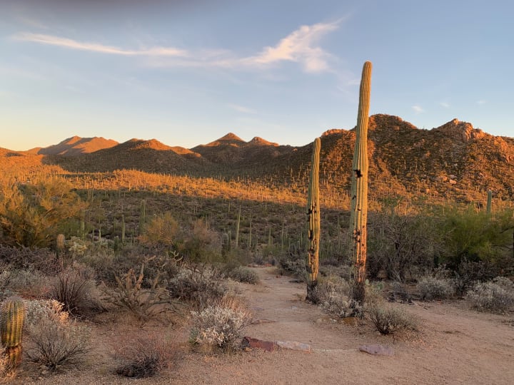
Day 3: Saguaro National Park (West)
On Day 3 we started visiting the destinations we set out to visit on the trip.
Saguaro National Park (pronounced Sawaro) is in two sections, the Tucson Mountain District on the West and the Rincon Mountain District on the East, with the city of Tucson, Arizona in between. It’s an hour’s drive between these sections.
We spent the entire Day 3 in Saguaro National Park West, except for an excursion to San Xavier del Bac Mission in Tucson. While the excursion was a good side trip, it took some precious time away from the park.
Check the map of the western park district for reference to locate landmarks mentioned below.
We took the Desert Discovery Nature Trail and the Valley View Trail, in addition to driving on the Bajada Scenic Loop (the yellow loop) and Gates Pass (off the map to the south).
The Desert Discovery Nature Trail is a must if you have not visited the park before. It explains several things about the desert, the Saguaro cactus, and other desert plants you see there. All of this in a very easy hike.

The Valley View trail is a good one to take as it is also an easy hike with a good pay-off. It ends at the top of a cliff with a panoramic view of the valley below. Standing at that high perch, you can readily appreciate the abundance of the Saguaro cacti in the area.
Our trouble was that we didn’t take that trail earlier in the day and we ran out of time to see all the spots we wanted to cover in daylight. We missed the highly recommended view of the sunset from Gates Pass.
We consoled ourselves about that miss because we have decided to visit the park again some year in March/April when the cacti will be in bloom. We’ll catch the Gates Pass sunset during that trip!
San Xavier del Bac Mission, Tucson
The dash over to this mission was on an impulse. We saw its attractive facade on a picture postcard and decided to check it out.
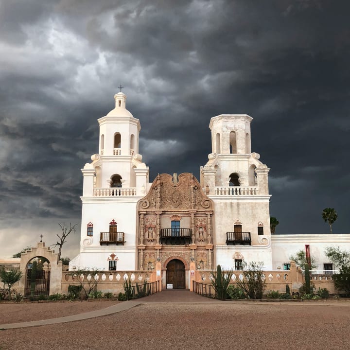
Unfortunately, I think it was being painted and half of it was in scaffolding, so the facade was nothing to savor this time. But we enjoyed the antique pews and the serene atmosphere throughout.
An annex dedicated to lighting candles in prayer had a cactus garden with a variety of cacti growing.
We spent Day 3 and part of Day 4 covering both sides of the park: West and East.
Day 4: Saguaro National Park (East) and then to Alamogordo, NM
While Day 3 was dedicated to spending in the western district, we used the first half of Day 4 in exploring the eastern district of the park. This eastern district, perched higher than the western side by about 2000 feet, has a different mix of plants. Even the saguaros here are more mature, with multiple arms developed, while those in the western side are generally earlier in their lifecycle, and are spears.
We started watching a virtual video tour put together by the National Park Service but ran out of time to complete it as we drove through the 8-mile paved drive ‘in a hurry’ to keep up with our schedule. Something to be taken care of on our future trip back in Spring some year.
Before we left Tucson after visiting the Saguaro National Park, we heeded a tip we received (check Day 2) and visited Beyond Bread, a local bakery that offers freshly baked bread and other goods. The loaf of jalapeno bread we got there would be a godsend in later days when we needed to whip up a quick lunch on the go as we were visiting the other National Parks.
Onward to Alamogordo, NM

Once we left the Tucson area, the transit was smooth. We would eventually leave I-10 at Las Cruces, NM, and go towards Alamogordo, a few miles north of our next destination: White Sands National Park. This segment was thankfully not as long and was also uneventful.
However, our zeal in spending time in the eastern district left us with a later than planned time of arrival in Alamogordo and made us scramble to find a restaurant for dinner. Denny’s came to our rescue.
White Sands being a missile testing facility, we needed to go through a checkpoint. At least, I assumed that was the reason for that checkpoint so far away from the Mexican border.
Day 5: White Sands National Park and then to Carlsbad, NM
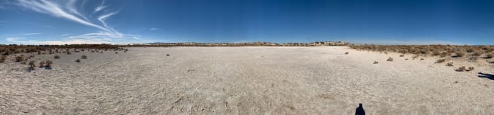
The expanse of pristine white sand in the middle of a desert is something to behold! We were fortunate to have the time to enjoy it without worrying about White Sands National Park being closed off to visitors.
When we planned the trip, we understood that if missile testing is scheduled, then the park would be closed to all visitors for a few hours. If all you have are a few hours to visit, you cross your fingers and pray to god that you don’t land up there at the wrong time. Our prayers seemed to have worked.
An informational video at the visitor center set the stage for understanding the park better. After picking up the customary items like picture postcards at the visitor center, we set off to explore the park. The drive within starts off as a paved road with trailheads for hiking. We took a couple of trails with exhibits that let us get an appreciation for the variety of animals and plants that manage to survive in what appears to be a barren land.
As we got deeper into the park, the road became unpaved and offered a different driving experience. Unlike the unpaved loop road in Saguaro West, the road here was excellently maintained and driving was a pleasure.
The road becomes a small loop in the end and offers several options to get down and clamber up sandbanks that look like snowbanks.
We saw several folks enjoying tobogganing on the slopes of the sand throughout the park.
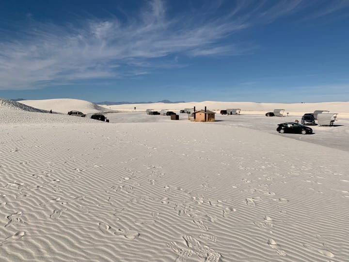
A bonus was a picnic area outfitted with what I thought were wind and/or sun shields and a restroom too!
Day 6: Carlsbad Caverns National Park, NM and Guadalupe Mountains National Park, TX

We had heard so much about Carlsbad Caverns over the years, it was a treat to finally visit that National Park. We were impressed right off the bat (pun intended) as we plunged down in an elevator that showed not the floor numbers but feet descended! And we discovered that the main cave was 750 feet below the visitor center!
Bats in caves is not a new concept. But we didn’t know that bats leaving the cave en masse at dusk to forage for food is a thing. Looks like it’s a spectacle to experience at Carlsbad Caves National Park. Only, our timing was off: The bats had left the cave for warmer weather during winter and were nowhere to be seen during our December visit. One more thing for a future visit!
We have seen other caves like the Luray Caverns in Virginia and California Caverns, but the scale of the big room here is something else. We went on the self-guided tour (the only kind available for the big room) but made the tactical mistake of not also renting the companion audio tour. We missed out on a lot of information, I reckon. Even so, there was a wealth of information from the exhibits.
It was interesting to note that the elevator drop-off point in the cave is developed into an elaborate assembly area with flush toilets and vending stations for food etc. The restrooms were open, but the other amenities were closed due to the pandemic. I am sure the ecology of the caves has been tweaked a smidgeon with all these “improvements”.
At the end of the tour, we were whisked back up all those 750 feet in a jiffy. The pressure equalization must be excellent; we never felt our ears pop or had any other discomfort during the rapid descent or ascent of those elevators!
Guadalupe Mountains National Park

As we were researching our destinations while planning our trip, we came across the Guadalupe Mountains National Park, situated a mere 45-minute drive from Carlsbad! We were not going to miss an opportunity to see and experience it. Due to the proximity of the park, we decided to make it a quick day trip, more as a reconnaissance for a possible future trip.
The Pinery Trail, a short, easy trail that starts from the visitor center, affords a look at the vestige of an old relic: The Pinery Station, one of the stops serving Butterfield Overland Mail, the first overland mail route from St. Louis, Missouri to San Francisco, California. This station was in operation from September 1858 to August 1859.
Even in the short time we spent at the park, we got to learn quite a bit about it and learned some history too! We also got to mark our presence in the state of Texas for a couple of hours.
Day 7: Carlsbad to Albuquerque

It is rare for us to plan a road trip where one or more days are without any planned activities. While Day 7 still had a planned activity, it was dedicated to just travel, no sightseeing. With just under four and a half hours of travel involved, what this allowed us to do was to take a proverbial breath after all those days of packed activities.
Some accomplishments that this pacing afforded us are writing postcards to send to friends and family, researching activities for the upcoming days, and simply resting a bit! We took an unhurried trip to the Carlsbad Post Office to buy stamps for the postcards we wrote and mailed those postcards later in the drive-through mailbox. With plenty of time at hand, we relaxed in the hotel until checkout time and started our drive to Albuquerque.
We got a taste of the desert dust storms on the way. While we were not engulfed in dust, we saw action at a distance. We also needed to keep dodging tumbleweeds across the highway; many times they would get really close and would seem to be targeting us. At 70 mph, even a small tumbleweed can do a number on the car, so we kept ourselves on high alert during the otherwise long and boring passage.
Even with all the relaxation throughout the day, we got to our hotel in Albuquerque early enough to have a choice of restaurants to consider for dinner.
Day 8: Petroglyph National Monument, Albuquerque
Day 8 was Christmas day for us. We were returning to Albuquerque after 29 years. We had explored the city more in our previous visit, including a hot-air balloon ride. It was our destination then, but not this time; it was more of a stop on the way.
We planned our stay in Albuquerque such that we would just spend the day without counting on any excursions and sightseeing. But we discovered that, within the confines of the city, there was an opportunity to check out an outdoor attraction: Petroglyph National Monument.

The visitor center at the monument was closed, of course. But there was enough information available to simply visit one of the trails, the Piedras Marcadas Canyon Trail, unencumbered. While the trail offered a good view of hundreds of petroglyphs, I was equally impressed with the way it was maintained. The trail surface was sandy and was kind on my foot that is sensitive due to plantar fasciitis.
One of the reasons we decided to stay put in Albuquerque on Christmas day is to maximize our chances of finding open restaurants. Otherwise, the day was available for impromptu local trips or simply for relaxation in our hotel room. This strategy worked really well and we caught up some more on communications. And we found a restaurant close by for dinner too.
Day 9: Albuquerque, NM to Petrified Forest NP, AZ to Holbrook, AZ

We were nearing the end of our trip with Day 9 dawning on us and just the last of the planned National Parks yet to be visited. Traveling on Interstate 40, the trip from Albuquerque to the park was short enough. However, we were under a strict timeline. The park closed at 5 pm and visitors were not allowed to be inside the park boundary after the gates close. But there was so much to see!
The visitor center at the north entrance off I-40 was not crowded. The ranger had the time and patience to give us a wealth of information about the park. The park map with 12 points of interest immediately told me we were going to be overwhelmed. Knowing the plight of many a visitor like us, the ranger gave us a tip: all the odd-numbered stops on the left of the map are important. Don’t miss any of them if you can help it. The even-numbered ones on the right are good but can take the back seat if time is a problem.
We did what we could, but even with these selective stops, we ran out of time. Among all the National Parks we visited on this trip, this is the one that clearly is screaming for a revisit. And there is so much information even from this abbreviated visit, I am already planning a dedicated post on this park. If you haven’t already sensed it, the painted desert panorama on the northern end and the abundance of petrified wood on the southern end are the highlights of the park.
It is interesting that the ranger manning the entrance booth, after giving the park map, added a simple instruction: “Don’t take anything from the park!” Couple that with the physical closing of the park after hours, and the only conclusion is that there must be stealing of the valuable artifacts going on. Perhaps you should make your way over there before they are all gone! (Just kidding, of course)
Day 10: Holbrook, AZ to Barstow, CA

Just as the first two days of the trip were dedicated to just getting there, we planned the last two days–Day 10 and Day 11–as days just to get back home. But along the way we got a tip that we can convert at least one of the days as a scenic drive, making it more pleasurable than a boring, long drive on Interstate 5.
But I am getting ahead of myself.
Day 10 was simply to get to Barstow, CA, traveling on I-40 all the way. The only rub was that the route took us through Flagstaff and Williams, the area known for snowstorms in December. There was a reason we were fleeing Boston all those years ago: we don’t like driving on snow (leave alone getting stranded due to impassable conditions).
We had been monitoring the weather forecast and decided our timing would work well in avoiding a 3-5 inch snowfall predicted for that area. As we were driving towards Flagstaff, we enjoyed the view of snow-clad mountains ahead of us, as seen in the photo above.
It turned out that we had perfect driving conditions: clear skies, beautiful sunshine, gorgeous view, and dry roads with snow just outside the road surface. We really enjoyed the passage through Flagstaff and Williams. We were thinking of Grand Canyon as we passed Williams.
With easy access from Williams, the Grand Canyon National Park was on our itinerary in our original plans. How it got dropped due to the weather conditions and how that became a godsend is another story.
On the way to Barstow, we stopped in Kingman, Arizona, to learn more about the historic Route 66 which connected Los Angeles and Chicago. The road in its original form is no longer available in its entirety, but there are sections that still retain its original flavor.
The historic significance of the route is recognized by the National Park Service. Information on efforts to preserve its heritage is available here. The Kingman Visitor Center offers a lot of information on Route 66, reflecting Kingman’s pride in being a key stop along this historic route.
Day 11: Barstow, CA to Fremont, CA

Finally, the home stretch! We had special plans for the final leg home. We had learned just a few days earlier something about California Rte 58 which spans the territory between Barstow on the east to Santa Margarita on the west. That it is actually scenic and has some historic and intriguing travel stops along the way. I decided that we will travel the complete CA-58 end to end, to not leave any of it out.
An important feature of this route is the Tehachapi Pass which offers a look at an ingenious railroad construction that enabled the track to scale a steep mountain using a curious loop that has the track going over itself. Long trains can be seen to go over the bridge where a section of the same train is traveling on the lower side of the same bridge.
But as luck would have it, there was light snow falling when we were on the pass and visibility was really poor. there was no point in trying to stop. We told ourselves that when we come back to see the National Parks of Arizona in springtime, we will visit the Tehachapi Loop.
To add insult to injury, the road conditions on the pass were snowy. We thought we had escaped snow on the road near Flagstaff, but the Tehachapi Pass made sure we would not escape it altogether! Oh well, at least it was just a dusting.
Where CA-58 shines is to the west of I-5 as it meanders through desolate sections and crosses the coastal range to meet US-101 in Santa Margarita. The last bit on US-101, towards home, is beaten track and we got home at the end of Day 11.
Closing thoughts
There you have it, in a nutshell.
I will be capturing our varied experiences, some wonderful and some not so pretty, in more detail with companion stories in the coming weeks. Hence, the true completion of this story and the associated ones will take a few days to weeks.
Here’s a sneak preview of what I am thinking:
If you enjoyed reading this story and want to see one of the companion topics written up before the others, please let me know your preference. I may choose the order of my writing accordingly.
If you want to be notified of the other pieces as they get posted, please consider joining my Friends & Family email list where I will keep you updated on the progress. Heck, even if you don’t care for more details of this trip, do consider joining…there will be other stories from time to time!
----------------------------------------------------------------------------------------
This story is an adaptation of the original here.
Please visit pvenkatraman.com to read other writings of mine.
Please subscribe to my newsletter if you wish to receive them each month directly in your inbox.
About the Creator
P. Venkat Raman
I write on diverse topics such as Personal Development, Travel, Finance, Gardening, Food, etc. I am a Vocal.Media member since Oct 2021.
Keep reading
More stories from P. Venkat Raman and writers in Wander and other communities.
Sundial Bridge: An Architectural Gem with an Uncommon Design
I stood mesmerized by the sleek, slanted, gleaming white column brightly lit by the evening sun against the clear blue sky. The cables tying the column to where I was standing, a pedestrian bridge across the Sacramento River in Redding, California with translucent glass panels for the deck, made it all the more intriguing and aesthetically pleasing.
By P. Venkat Raman3 years ago in Wander


Comments
There are no comments for this story
Be the first to respond and start the conversation.