
The Drawstring Harbors: How Geography Picks a Navy’s Home
Lüshun, Pearl Harbor, Cam Ranh Bay, and the narrow-mouthed bays that decide what a fleet can do.
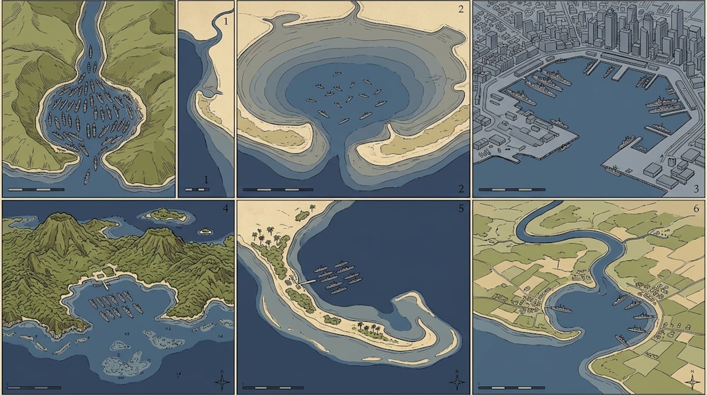
A good naval harbor often looks, from the air, like a drawstring bag. The sea outside is a moving blue field. The entrance is a narrow neck. Inside, hills, peninsulas, and islands close around a broad sheet of sheltered water. The old rule of thumb is simple: a small mouth, a large bag, good depth, and a tidal range that does not make trouble. A small mouth keeps swell out, makes the channel easy to watch, and gives the defense a chokepoint. A large bag gives room for anchorages, berths, repair yards, and dispersal. Depth lets large ships and submarines move without waiting on the tide. A small tidal range keeps piers, mooring, channel depth, and mine countermeasures from becoming a daily calculation.
But a naval harbor is not chosen by terrain alone. Terrain is the draft. Geography, hinterland, rail and road links, shore-based aviation, air defense, anti-submarine nets, fuel, repair, and strategic direction are the text. Terrain decides whether a place looks like a good pocket. The system decides what the pocket can hold and how long it can hold it.
Lüshun: A Textbook Mouth, a Tight Bag
Lüshun, known in older maps as Port Arthur, is the classic example of the pocket harbor. Its entrance is only about 600 meters wide. Hills stand on both sides like gateposts. The water inside is deep enough, the tidal range is small, and the port stays ice-free in winter. From a defensive view, the entrance is close to ideal: narrow enough to watch, to mine, to block, and to cover with fire. It is sheltered enough to keep outside swell from rolling into the anchorage.
The weakness sits inside the bag. Lüshun’s harbor basin and shoreline are limited. A modern fleet needs more than a safe anchorage. It needs multiple berths for large ships, repair space, fuel storage, ammunition handling, road and rail access, and room to disperse. Lüshun offers an excellent mouth and a bag that is tight for a large fleet. It works as a fortified naval point, a submarine base, and a regional defensive anchor. It is less suited to carrying a whole ocean-going fleet by itself. The terrain is a finely made dagger: sharp, well-balanced, and short.
Sandu’ao: A Large Bag, a Strong Tide, and Matsu Outside
Sandu’ao, on the Fujian coast, is the harbor that naval enthusiasts like to imagine as a future fleet base. Its mouth is about 3 kilometers wide, and the bag inside is much larger than Lüshun’s. The bay reaches inland among hills, with a long shoreline and enough space to imagine berths, anchorages, and supporting industry. On the large-bag test, Sandu’ao is generous.
Two problems sit on the other side of the ledger. The first is tidal range. Sandu’ao belongs to the Sansha Bay system, a strong-tide area on the Fujian coast. Mean tidal range is roughly four to five meters, and spring tides can reach seven to eight meters. That is large for a Chinese coastal bay. A large tidal range does not make a harbor impossible. It makes engineering and operation more expensive. Pier heights, mooring arrangements, berthing windows, channel depth, anchorage swing, mine-laying and minesweeping baselines, and submarine sorties all have to account for moving water. Strong tides also flush the bay, which helps keep sediment from silting up the channels. The tide is a cost and a benefit.
The second problem is outside the mouth. The Matsu Islands sit near the entrance. Sandu’ao has not been activated as a major naval base, and its military value is framed by the Taiwan Strait, political relations, and the wider battlefield system. A large, deep bag is a natural gift. A strong tide and a sensitive approach are conditions attached to the gift.
Port Phillip Bay: A Fine Harbor in the Wrong Strategic Corner
Port Phillip Bay, the water body beside Melbourne, has a mouth of about 3 kilometers and a large interior. Its hydrology is good, its shoreline is long, and Melbourne grew into Australia’s largest city on the strength of the bay. As a harbor, it is excellent: wide water, good depth, room for commercial berths, industry, and urban expansion.
Its naval value is limited by location. A fleet based at Port Phillip Bay is far from the western Pacific and the Indian Ocean. Moving major forces from there toward any likely strategic direction takes time. The bay is a spacious, well-lit house at the end of a quiet street. It works for commerce. For a navy, it would make sense only if the strategic problem were a penguin crossing. Terrain can be excellent and still be in the wrong place.
Pearl Harbor: The Standard Answer
Pearl Harbor is the standard answer to the pocket-harbor question. Its mouth is about 800 meters wide. The bag inside is large. The water is deep. The tidal range is small. The shoreline offers room for berths, repair, fuel, aviation, and command facilities. The entrance is narrow enough to defend and wide enough to sortie. The Hawaiian chain gives depth behind the harbor. The Pacific position gives the base strategic reach.
Pearl Harbor’s strength comes from the shape of the water and the system built around it: shore-based aviation, anti-submarine surveillance, fuel storage, repair yards, communications, and a logistics chain that stretches across the Pacific. The terrain provides the skeleton. The system provides the muscle and blood. This is why Pearl Harbor is often used as the benchmark: the mouth is small, the bag is large, the tide is quiet, and the geography sits on a major strategic line.
Havana Bay: The Extreme Narrow Mouth
Havana Bay takes the narrow mouth to an extreme. Its entrance is less than 300 meters wide. The bay inside is sheltered, the tidal range is small, and the harbor helped Havana become the largest city in the West Indies. A mouth that narrow is easy to defend. Shore batteries, mines, blocking nets, and observation posts can cover the entrance in layers. The water inside stays calm, and ships moor in sheltered conditions.
The same narrowness creates costs. The channel is crowded. Large ships have little room to maneuver. The exit is single. If the entrance is mined or blocked, the fleet inside becomes a fleet in a jar. Cuba has many harbors of this pocket type. Cienfuegos in the south and Guantánamo Bay in the east are other examples. Guantánamo Bay later became a U.S. naval base, which shows how useful the pocket shape can be to an outside power. Havana Bay is a pouch pulled tight at the neck: safe, sheltered, and hard to turn around in.
Guanabara and the Tagus: When the Mouth Widens, Depth and Hinterland Take Over
Guanabara Bay, beside Rio de Janeiro, has a mouth of about 1.7 kilometers. The bag is large, the water is deep, and the bay is a Brazilian navy base. It is no longer a strictly small-mouth harbor, but islands and peninsulas give the entrance some cover. The bay’s strength is the size of the interior, the length of the shoreline, and the city and industrial hinterland of Rio. Its weakness is that a 1.7-kilometer mouth is harder to close than Pearl Harbor’s 800 meters.
The Tagus estuary beside Lisbon also has a mouth of about 1.7 kilometers. Lisbon’s harbor value comes from the river as much as the bay. The Tagus reaches inland, and the city sits at the point where river depth, sea access, and hinterland meet. Portugal’s Atlantic voyages began from this estuary. The Atlantic tidal range is larger than in Mediterranean-type harbors, so the Tagus asks more of piers, mooring, and channel management than a quiet bay does. The river gives depth and hinterland that a closed bay cannot match. The pocket can be an estuary, as long as the neck opens to a river with reach.
Sasebo: A Note on Choosing a Naval District
Sasebo Bay has a mouth of about 900 meters. The bag inside is well shaped, the tidal range is moderate, and the bay became one of the four main naval districts of the old Japanese navy: Yokosuka, Kure, Sasebo, and Maizuru. The choice was not accidental. A naval district needs a mouth that can be defended, a bag that can hold ships, a hinterland that can repair and supply, and a position that faces a strategic direction. Sasebo faces the East China Sea and the approaches to the Korean Peninsula and the Chinese coast. Its geography gave it weight.
One geographic correction belongs here. Kure is in Hiroshima Prefecture. Sasebo is in Nagasaki Prefecture. Hiroshima and Nagasaki were the two cities hit by atomic bombs in 1945. The naval ports are not the same municipalities as the bombed cities. The places are close enough in memory to be confused, and precise enough in geography to keep separate. Kure and Sasebo are naval district names. Hiroshima and Nagasaki are city names. The map does not allow the concepts to blur.
Cam Ranh Bay: Large Bag, Deep Water, Small Tide, Sensitive Geography
Cam Ranh Bay is often called the best deep-water harbor in Southeast Asia. France, Russia, Japan, the United States, and the Soviet Union each leased or used it as a naval base at different times. The bay has an inner and outer structure, with peninsulas closing around the water. The interior area is large, depth runs roughly from 16 to 25 meters, and the mouth is several kilometers wide. The inner bay is sheltered, and the South China Sea tidal range is usually small, on the order of one to two meters. Cam Ranh passes the large-bag, deep-water, small-tide tests.
Its problem is geography in the political sense. The bay faces the South China Sea. Any major navy based there changes the regional balance. The mouth is not extremely narrow, so modern surveillance and long-range strike reduce the value of hiding inside. The exit opens to open water, and the defense needs strong shore-based aviation, air defense, anti-submarine warfare, and a layered surveillance system to pull the pocket closed. Cam Ranh is a large, well-made bag with its mouth in a windy place.
Tidal Range: The Underrated Variable
“The tidal range should not be too large” sounds like a minor technical note. It is not. A small tidal range simplifies piers, mooring, berthing windows, channel depth, and mine countermeasures. A submarine can leave without waiting for a particular water level. A mine-laying plan can use stable depth references. A pier does not need extra height and extra length of mooring line for every berth.
A large tidal range raises the cost of every fixed piece of infrastructure. Pier heights, gangways, fenders, mooring systems, dry docks, and channel dredging all have to absorb the rise and fall. Strong tides add current, anchorage swing, and sortie timing. They also flush sediment, which can reduce dredging in some bays. Sandu’ao’s large tide is one of its main differences from Lüshun, Pearl Harbor, and Havana Bay. Treat the tide as an engineering line item that never goes away, not as a veto.
The Pocket in Modern War
The traditional advantages of a pocket harbor are shelter from swell, control of the entrance, protection from sudden raid, and a narrow channel that can be watched and mined. Modern war changes part of that logic. Satellites and remote sensing make a large fleet in a harbor hard to hide. Precision-guided weapons make fixed basins high-value targets. Mines, submarines, unmanned surface vessels, and cruise missiles turn a single exit into a risk. A closed bay that is easy for the defender to seal is also easy for an attacker to seal.
A modern naval base therefore needs four qualities: it must be defensible, sortie-capable, dispersible, and sustainable. The mouth cannot be so wide that defense becomes impossible. It cannot be so narrow that the fleet is trapped. The interior needs multiple anchorages and dispersal water. The shore needs air defense, anti-submarine nets, repair, fuel, ammunition, and road and rail depth. A civilian port and backup anchorages can absorb part of the load. The pocket is a natural advantage. It cannot be the only plan.
Conclusion: Draft and Text
Place these harbors side by side and no single one wins every category. Lüshun has an excellent mouth, hills for cover, small tide, and ice-free water, but the bag is tight. Sandu’ao has a large bag and good depth, but a strong tide and the Matsu Islands outside the mouth. Port Phillip Bay has fine water and a large interior, but it sits in a strategic corner. Pearl Harbor has the small mouth, large bag, small tide, and Pacific position that make it the benchmark. Havana Bay pulls the mouth under 300 meters and gains shelter at the cost of a single crowded exit. Guanabara Bay and the Tagus estuary show that when the mouth widens, depth and hinterland take over. Sasebo shows how a naval district chooses a bay. Cam Ranh Bay shows a large, deep, small-tide bag with a sensitive address.
A naval harbor is a pocket. The mouth must hold. The bag must hold ships. The bottom must be deep. The tide must not make trouble every day. But the pocket is sewn onto a strategic map. Terrain is the draft. The system is the text.
About the Creator
Jin
Writer of reamstories
https://reamstories.com/jin
Enjoyed the story? Support the Creator.
Subscribe for free to receive all their stories in your feed. You could also become a paid subscriber, letting them know you appreciate their work.
Comments
There are no comments for this story
Be the first to respond and start the conversation.