

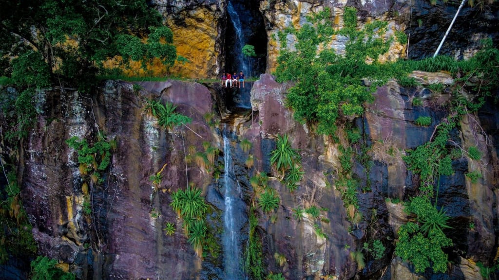
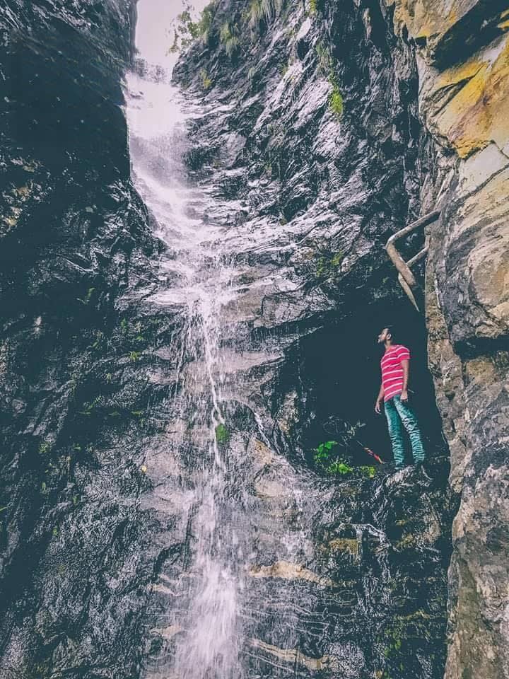
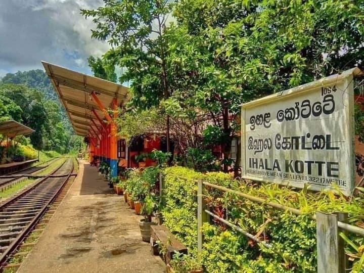
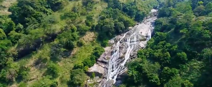
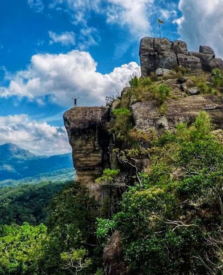
Many environmentalists, waterfall aficionados, and members of the general public in our nation are unaware of Meeyan Ella Falls. At the very least, few people even know where it is. This waterfall is situated close to the Ihalakotte train station along the Kandy railway line. Helan-Madiththa, a location on the Alagalla mountain, is the source of the stream that forms the Meeyan Ella waterfall. The waterfall's original course passed through the villages of Walagoda and Thalagolla before merging with Thalagolla Oya. It then fell as a single stream over a rock. The connection between Ma Oya in Boella and Thalagolla Oya follows.
However, the waterfall now divides into two segments with a 50-meter separation. A fascinating tale of how a large waterfall was once split into two smaller ones. To carry products, especially Ceylon tea from Kandy for export during the British Colonial Era, the Colonials built a railway line between Colombo and Kandy. The mid-1800s saw the construction of the railroad line between Polgahawela and Kandy. The Colonials at Alagalla had the difficult task of building the railway over the substantial waterfall Meeyan Ella. As a result, the Colonials were forced to complete the enormous task of digging a tunnel through the Alagalla rock, which was around 304 meters (1000 ft) deep. Instead, they looked for other options, and after examining the location, they came to the conclusion that the only choice was to obstruct the cascade upstream and carve two significant grooves into the rock. As a result, instead of one large waterfall, the water would cascade into two smaller ones. After the job was finished, a horizontal cut through the Alagalla rock measuring about 426 meters (1400 feet) long and five meters (18 feet) deep was made in order to build the railway line, which was finished up to Kandy in 1867. This groove was unable to handle the tremendous rush of water in the stream during severe downpours, and the railway was repeatedly carried away. Due to their difficulty pronouncing "Meeyan Ella," the British Colonials dubbed the waterfall "Meen Galla."
History
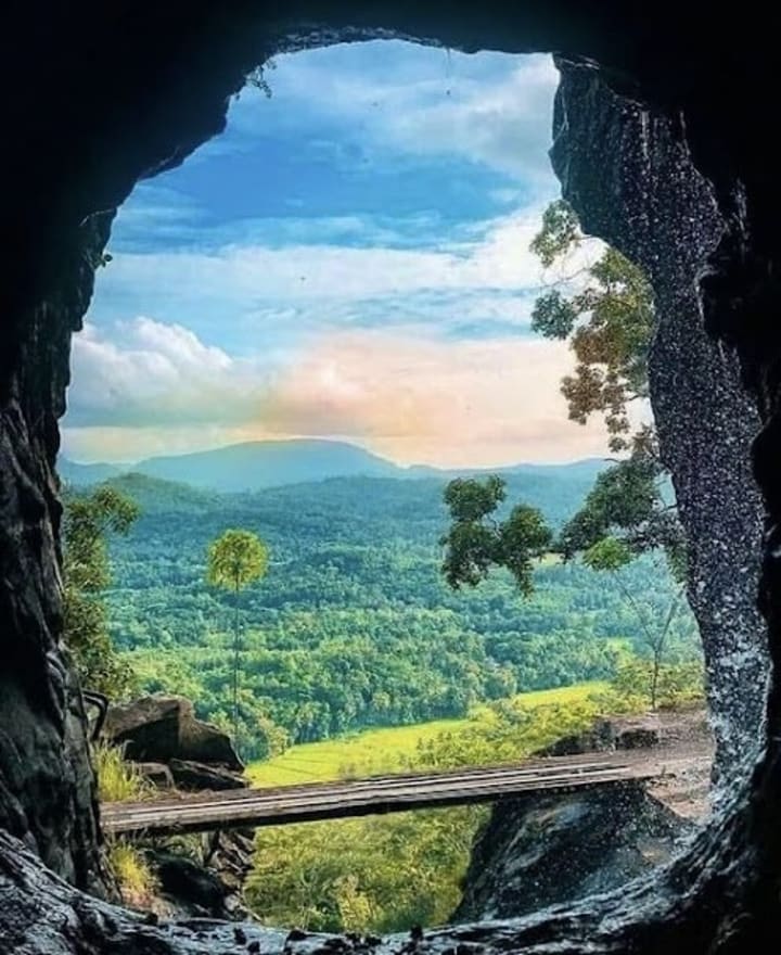
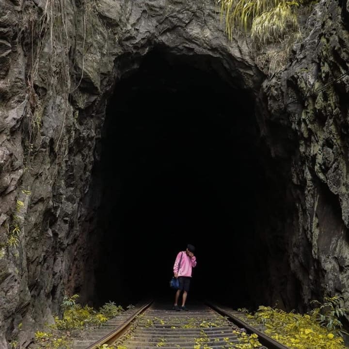
Engineers opted to build the tunnel as originally intended during the 20th century after realizing that this groove acted as a death trap during the wet season. Thus, between 1905 and 1906, a tunnel 400 meters (1307 feet) long was built through the Alagalla rock. The second-longest railway tunnel in Sri Lanka is Tunnel 5A, which was recently built between Tunnels 5 and 6. The longest is Singimale Tunnel, which is 558 meters (1865 feet) long and is located between Hatton and Kotagala railway stations. It is reported that during the tunnel's construction, this hole was utilized to remove rubbish. Fresh air may now enter the tube through this aperture.
It takes around 275 meters to get to Sangaraja Lena (a tiny cave where *Venerable Welivita Sri Saranankara Thero had stayed in seclusion while learning Pali Language) from Ihalakotte Railway Station in order to access the divided waterfalls. After that, it will take you around 225 meters of walking down the rail line to get to Tunnel 5A's entrance. Travelers who want to explore the tunnel must speak with the railroad personnel at Ihalakotte Railway Station to get the most recent train schedules since doing so might have catastrophic implications given that the tunnel is 400 meters long. Due to the Meeyan Ella waterfall pouring over it, the tunnel is typically moist. After traveling about 75 meters, a sizable hole in the left wall leads to a cliff's edge outside. Folklore has it that when the tunnel was being dug, this pit had been used to dump debris. For the time being, this aperture gives tunnel users access to fresh air. The second tunnel may be accessed after passing through the 5A tunnel for around a few minutes. A cave tunnel is the second tunnel. Some tourists have described it as "a tunnel inside a tunnel," an incredible experience.
Folklore holds that the coconut tree at the start of the old rail path marks the resting place of S.P. Appuwa, who worked on the team that drilled Alagalla Mountain to build the tunnel and maintained the railway line until his retirement. S.P. Appuwa was born in Ihalakotte in 1880 and passed away in 1974. The burial of Gallene Gedhara Samara, a railroad patrolman who toiled and died, is also marked by the banana plants to the left.
Although the place may also be reached by car, it is simpler to visit this location for people going by rail from Kandy to Colombo because it is close to Ihalakotte Railway Station.
How to Get
For those traveling by train: Travel on the upcountry railway line from Kandy to Colombo and reach Ihalakotte Railway Station.
For those traveling by vehicle: Travel up to Mawanella town and thereafter travel approximately five kilometers along Rambukkana road to Ihalakotte Railway Station.
Places Near
- Alagalla Mountain
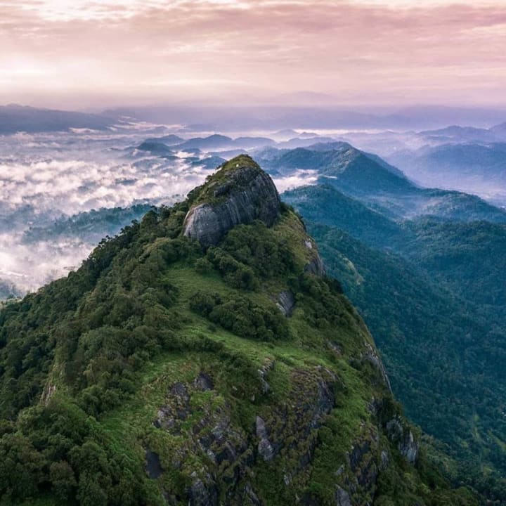
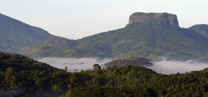
The potato-shaped rock known as "Potato Mountain" and located in Sri Lanka's Alagalla Mountain Range, also known as the "Potato Range," offers breathtaking views and has served as a natural defense location against Portuguese, Dutch, and English invasions targeting the Kandyan Kingdom from 1505 to 1815. Legend has it that residents of Kandy and the surrounding area hid among the cliffs that border Hatharaliyadda and Thumpane (village located next to the Mountain) during foreign invasions and retaliated against the Portuguese, Dutch, and British.
During the era of the Kandyan Kingdom, the majority of conflicts against foreign invasions by western countries targeted at the Kandyan Kingdom took place at Alagalla Mountain, at Balana (View Point), which is located between *Kadugannawa Pass and Potato Range.
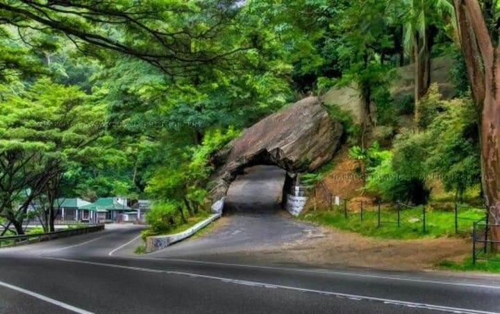
- Kadugannawa Rock Tunnel
The Rock Tunnel and Kadugannawa Pass are significant sights along the Colombo-Kandy Road. The Central Highlands and the UNESCO World Heritage Site Kandy are both accessible from Kadugannawa. The highest point of the Colombo-Kandy Road's ascent is known as Kadugannawa Pass. The Kandyan Kingdom used it as a vantage post in the 16th and 17th century to keep an eye on invading foreign armies coming from Sri Lanka's lowlands. The Kandyan Kingdom maintained an outpost in Kadugannawa, and several fights had previously taken place here. Locals refer to the Rock Tunnel as Gala Vidapu Thena, which in Sinhala means "the rock that was pierced." The Rock Tunnel has served as a representation of the Colombo-Kandy Road since the dawn of time.
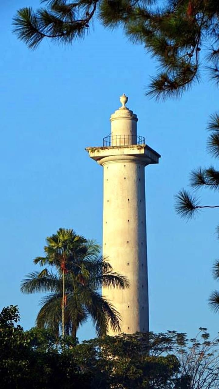
- Dawson Tower
There is a towering column to the right of the cliff before you get to Kadugannawa town that many people mistake for a military memorial. This massive monument honors Captain William Francis Dawson, a Royal Engineer who served under British Governor Edward Barnes during the British Colonial Era and directed the building of the Colombo-Kandy Road (1824 – 1831). This enormous, 38-meter-high white obelisk, which resembles a lighthouse, is a landmark on the Colombo-Kandy Road and is easier to view from Kandy than from Colombo.
After the Kandyan Rebellion was put an end in 1818, Governor Barnes believed it was important to maintain control over the former Kandyan Kingdom's territory and that a direct route from Colombo to Kandy was essential.
- Bible Rock
Bible Rock is hidden by dense vegetation and is referred to by locals as Bathalegala. One can question if it is indeed climbable given that the Rock appears to ascend almost vertically. It rises to a height of 798 meters above sea level and is located close to Aranayaka in the Kegalle District of central Sri Lanka. The same road that the British used to invade the Kandyan Kingdom in 1815, Kadugannawa Pass on the Colombo-Kandy Road offers spectacular views of this interesting mountain. Anyone driving between Kandy and Colombo may view Bible Rock, but those using the train from Colombo to Kandy can also easily see it.
This rock was given the name Bible Rock during the British era because it resembles an open book or the Bible when seen from the British-built Kandy Road. The Rock and the well-known Sigiriya Rock are comparable.
- Dolosbage to Dedugala
Dolosbage, which translates literally from Sinhalese as "half dozen", is a mountain range approximately 100km east of Colombo, and 40km southeast of Kandy. Located in the middle of Sri Lanka's tea-growing region, the six mountains of Dolosbage are cloaked in thick jungle and laced with wilderness trails that provide the explorer with a variety of experiences; from a weekend of camping in the open to a day of mountain climbing, or a few hours of hiking. This is one of the scenic roads full of greenish mountains & gets misty.
Read : https://zeloan.blogspot.com/2022/10/dolosbage-to-dedugala-in-sri-lanka.html
- Kabaragala Mountain Range
In Sri Lanka's Dolosbage Mountain Range, Kabaragala is the mountain's highest summit. This is situated where the districts of Kagalle and Kandy meet. The summit rises 1506 meters above sea level. Similar to the Horton Plains, it has an almost level topography. Moreover, a massive fallout akin to the Word End. It is situated in Sri Lanka's Sabaragamuwa Province. The mountain range is known as Kabaragala, according to the locals, because of its speckled iguana-like appearance. On one side of the mountain, when you reach the peak, a steep slope may be seen on the opposite side. You may ascend the mountain farther to view a number of interesting locations. The natural forest and grasslands at the top of the hill contributed to the splendor of the mountains. A windbreak that produces an endless stream of winds is also present. The natural environment may be explored quite well here.
Read : https://zeloan.blogspot.com/2022/08/kabaragala-mountains-in-sri-lanka.html
- Asupini Ella
Asupini, which may be translated as "the horses leaped over the falls," has a fascinating prehistoric origin story. Aswaya means "a horse," and Pini or "Panina" means "to jump." There may have been a king who wedded several queens. He had once told his queens to wait closer to this waterfall until a flag was flown to declare his triumph or loss before embarking on a war. All the queens jumped into this waterfall at the end of the war and perished. The king's soldiers were waving a white flag. As a result, Asupini Ella is also known as Ahupini Ella.
About 30 meters tall, Asupini Ella rises from both sides of Raksawa Mountain and merges with the Maha River. It is situated in Sabaragamuwa Province's Aranayaka, Kegalle. This waterfall is used to mark the boundary between Satara Korale and Paranu Kuru Korale, according to ancient Sri Lankan history.
- Uthuwankanda
Beautiful mountains, rivers, and green paddy fields can be seen at Uthuwankanda. The Uthuwankanda Temple, where you will meet the noble monk, is where the tour of the Uthuwankanda Village begins. After giving a brief explanation of the temple's historical significance, he will allow you to have a freshly made Sri Lankan breakfast.
On this voyage, four significant locations must be visited. These include Bo Fall, Saradiel Rock, Saradiel Cave, and Saradiel Theme Park. One of the primary adventure activities on this tour is the rock climb in Saradiel. You may need to sneak through several locations as you explore the cave tube, which makes the experience extremely adventurous.
Mawanella's Saradiel settlement is about a mile from the Uthuwankanda intersection. You will be accompanied on a guided tour during which our guide will explain the birth and demise of the Saradiel.
Google Map:
About the Creator
Zeloan
I'm a Traveller, Blogger, and Content Creator. Visit Sri Lanka, and you can see the most beautiful places in the world and the remarkable hospitality here
Did We Manifest AI Due to Collective Human Attitudes on Work?
Food for thought indeed. There is a mighty fine line between "AI is taking our jobs" as a downright conspiracy theory, to something that is true and proven in some (if not many) occupations; from cashiers to illustrators, and robotic surgery to name, let alone robot lawyers for real. Furthermore, this article is not designed to create more fear and uncertainty than what is already circulating in the cosmos, but rather to view AI and the world of work from a different perspective.
By Justine Crowley22 days ago in Journal
Illuminating Crawley: J S Electrician Sheds Light on Professional Electrical Services
Reliability in electrical services is always needed in Crawley, a vibrant town where historical charm and contemporary infrastructure blend together perfectly. To keep the town powered and safe, qualified electricians are essential for tasks including industrial maintenance, commercial installs, and residential wiring. One name sticks out in the middle of this demand: J S Electrician.
By J S Electrician3 days ago in Journal
The Fish Song
The room didn’t smell like disinfectants. Its fragrance seemed light and not overbearing. A soft mixture of lavender and mint permeated the space. No beeping machines or any tubes hooked up to four-year-old Kaleeka. Her cacao skin seemed to glow from the light over her head. The family, save for one and the doctors and nurses exited the room like a trail of saints showing their last vestiges of regard.
By Skyler Saunders6 days ago in Fiction


Comments
There are no comments for this story
Be the first to respond and start the conversation.