
The Forest That Swallowed an Army
Inside WWII’s Most Miscalculated Battle

ABSTRACT
The American advance into the Hürtgen Forest was both slowed and costly due to multiple factors that were overlooked by the 1st Army’s commanders and intelligence. The factors included the impacts that the dense pine forest had on maneuver elements and air support, the impacts of the valleys, ridges, and streams on offensive operations, and the series of manmade bunkers, pillboxes, and other obstacles that created a formidable defense of the area. This battle analysis uses information from primary sources and reports written on the battle to develop an in-depth examination of Hürtgen’s military geography. The features listed above created one of the most difficult environments to fight in for the U.S. Army. As a result of the geography and the enemy, the Hürtgen Campaign concluded with no decisive victory for the Allies.
Introduction
The history of the longest battle fought by the U.S. Army in World War II, the Battle of Hürtgen Forest, is not as well-known as many other battles and its strategic importance is often debated. However, the battle provided some important lessons about the current state of the German military and how impactful the geography and environment can be on combat operations in the European theater of war. The American advance into the Hürtgen Forest was both slowed and costly due to multiple factors that were overlooked by the 1st Army’s commanders and intelligence. The factors overlooked included the impacts of the dense pine forest on ground maneuver and air support, the impacts of the valleys, ridges, and streams on offensive operations, and the series of manmade bunkers, pillboxes, and other obstacles that created a formidable defense of the area.
General Description of the Battle
Following the Allied invasion of Normandy and the drive through France, the Germans had withdrawn and reorganized to defend their homeland. The Allied advance was slowed due to the stretching supply lines and the challenging task of crossing the Siegfried Line, also known as the Western Wall, to enter Germany. Positioned north of General Omar Bradley’s 12th Army Group and south of General Bernard Montgomery’s 21st Army Group, the 1st Army, under the command of General Courtney Hodges, was sent west in the vicinity of Aachen, Germany (see Map 1). Beginning on 12 September, the 1st Army’s initial task was to protect the flanks of the adjacent army groups by securing Aachen and clear the surrounding area of any German resistance (Miller, 1995). Just south of Aachen is the dense Hürtgen Forest, which the Siegfried Line passed right through. In late October, the purpose for operating in the forest quickly shifted from just clearing the area of enemy forces to securing the Roer River Dams (see Map 2). After discovering the dams, this objective became the priority because if the dams were destroyed by the Germans, the flooded region would have a devastating impact on the 1st Army’s advance into Germany (Newland & Chun, 2011). From this point, the battle over Hürtgen Forest became a slow and sluggish fight that would expend countless resources and multiple divisions before it was over.
Geographic Setting
The Hürtgen Forest is a twenty-mile-long by ten-mile-wide forest that sits on the northern part of the massive Ardennes-Eifel Plateau. It has some of the deepest draws and valleys. The valleys are split up by several creeks and streams with the Roer River forming the forest’s southeastern border (MacDonald, 1963). The hydrology of streams and marshy land surrounding them made it easy for flooding to occur. What limited roads and trails there were in the forest, quickly became muddy due to the damp environment (see Map 2) (Drea, 1983). The vegetation in the Hürtgen Forest was manmade with many planted trees. Many pine trees spanned over 100 feet tall and with such a high concentration, the trees limited the amount of light that was able to reach the forest floor. The ground was covered with moss and damp pine needles, some stacked up to ten inches (Newland & Chun, 2011). From late September to December, the weather in the area was anything but nice. In Drea’s 1983 report, he states:
The weather was cold, damp, misty, and generally uncomfortable, although not quite freezing… there had been so much rain that the ground was saturated and water stayed on the surface (p. 34).
The mist and rain combined with the cooling temperature as winter approached made a dense fog that stayed in the forest. Above the forest were many low clouds that covered the sky, blocking even more sunlight from reaching the ground.
In addition to the natural geographic factors, there were multiple manmade features that complemented the forest’s terrain. Pillboxes and entrenchments were constructed by the Germans, creating strongpoints that overlooked the natural corridors through the forest. The bunkers were built and aligned in depth, sometimes camouflaged as buildings/power stations (Miller, 1995). In many places, concertina wire, booby traps, and minefields were used by the Germans to create a complete defensive line throughout the Hürtgen Forest (Snow, 1984).
Impact of Geography
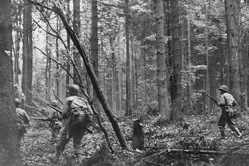
The impact of the forest’s vegetation hindered and helped both forces throughout the battle. The denseness of the area acted as a natural obstacle, it prevented nearly all U.S. armor freedom to maneuver outside of the few roads and trails that were wide enough to support them. Underneath the canopy of the tall trees, very little light made it extremely hard to see ahead. Depending on the time of day, sometimes soldiers could only see out a few feet (Miller, 1995). On the clear day when aircraft could fly, their capabilities were limited due to the dense foliage. This also impacted artillery on both sides, shells would land but it was difficult to adjust fires because observers could not see where they were impacting. The Germans chose to have their artillery and mortars detonated in the air creating tree bursts, this fragmentation from the exploding trees became very effective in the Hürtgen Forest (Newland & Chun, 2011). The trees and ground vegetation also helped in concealing troop movements once in the forest. Soldiers on both sides could reinforce or withdraw from their lines without being seen.
The landforms, pillboxes/bunkers, and obstacles within the forest aided the Germans in effectively defending their position, despite having fewer men. In the forest, the elevation goes up from west to east. This positioned many of the German strongpoints on high ground which made it challenging for the Americans to attack their objectives. Although they could not see troop movements within the forest, there were some hills that allowed the Germans to see where the U.S. forces moved into the forest (Snow, 1984). A major obstacle that became a feature of the land was the line of concrete pyramids, known as dragon’s teeth, which blocked almost every path where a tank or heavy vehicle might be able to advance. American units had the task of clearing these obstacles; however, a series of German pillboxes overlooked the dragon’s teeth with intersecting sectors of fire. In one location, a series of seven pillboxes held off an entire regiment for several days, the cost to take out these fortifications was devastating for the Americans (MacDonald, 1963).
In addition to the dragon’s teeth and the pillboxes, reinforcing obstacles like concertina wire and minefields slowed U.S. troop movements throughout the forest. Many of these mines were located around the few roads that went through the forest, as it was the only efficient way for equipment and ammo to be transported to the forward units. The only way to remove the mines was by detonating them because the Germans would use anti-lifting devices. These detonations would create craters in the road which had to be repaired once the roads were cleared of antitank mines, this took more time and manpower, slowing the American supply line within the forest (Snow, 1984). The Germans also had preplanned targets wherever antipersonnel minefields or wired obstacles were, so once troops were slowed down by the obstacles, they were hit by indirect fire. Due to this, the Americans relied heavily on their engineers to maintain roads and clear paths for the infantry.
Constant artillery fire and the danger of stepping on a mine began to eat at the American soldiers’ morale, but the poor weather and the fluvial landscape within the Hürtgen Forest had the largest impact on the soldiers. As stated earlier, the air was cold, damp, and uncomfortable. This paired with a lack of coats, overshoes, and blankets, mainly due to soldiers ditching them in combat, led to many cases of walking pneumonia and trench foot (Drea, 1983). The misty fog and low cloud cover limited observation capabilities, it also prevented allied aircraft from flying over the forest. When the rain would pick up and the ground became muddier, the soldiers were quickly exhausted from sludging through the thick mess. The mud had an even greater impact on allied vehicles. Firebreaks and trails were impassible creating supply shortages. Tanks and tank destroyers easily got stuck in the mud, rendering them useless. Another effect of the rain was that any exposed foxholes would fill up with water and the small streams flowing through the forest valleys would easily flood. This limited where the Americans could traverse through the forest and decreased their morale even more (Snow, 1984).
One final feature that impacted how the fighting played out in the forest was the general location. Set right on the border of Germany and Belgium, the Hürtgen Forest was one of the first battles where the Germans were defending their homeland. Faulty assumptions by Allied commanders predicted that the will of the German soldier was dwindling and that the war would be over by the end of the year. The initial push into the forest happened prior to Operation Market Garden, which would show that the Germans were still in the fight. The forest was believed to be defended by old men and young boys, their eagerness to fight and their effective use of the defensive terrain proved that a smaller force could hold off the strength of the advancing American Army (Newland & Chun, 2011).
Summary and Conclusions
The slow and sluggish combat that ensued following the American advance into the forest on 12 September 1944 lasted until 16 December 1944 when the German Ardennes Offensive, also known as the Battle of the Bulge, began. This fight was extremely costly to both sides, with the Americans and Germans each having about 33,000 casualties. One of the biggest factors in this battle was not the high concentration of units in the area or the actual combat, but it was the forest itself. Just under a third of all American casualties were to due to poor weather and adverse environment. In Charles MacDonald’s book on the battle, he puts it in perspective of other battles by stating:
In World War II, losses of 10 percent were considered high. These [Hürtgen] were losses of more than 25 percent (p. 196).
The impact of the geographic features listed above each played a pivotal role in how the battle was fought and why so little progress was made. The dense vegetation of tall pine trees blocked light from entering the forest floor. The trees both positively and negatively impacted the use of artillery by either having tree bursts rain shrapnel and splinters onto infantry or by blocking observers' view to adjust fire. The German obstacles, minefields, and pillboxes constructed to complement the valleys and ridges formed a defense in depth. The poor weather and muddy terrain decreased soldiers’ morale and reduced the ability for vehicles to bring in supplies and bring out wounded. Overall, the Americans achieved their objective of preventing the Roer River Dams from being blown to flood the entire area. However, the price for accomplishing the objective that was “stumbled upon” and with little to no ground gained can outweigh any benefits, making it hard to argue that the battle was an American victory and is commonly given to the Germans.
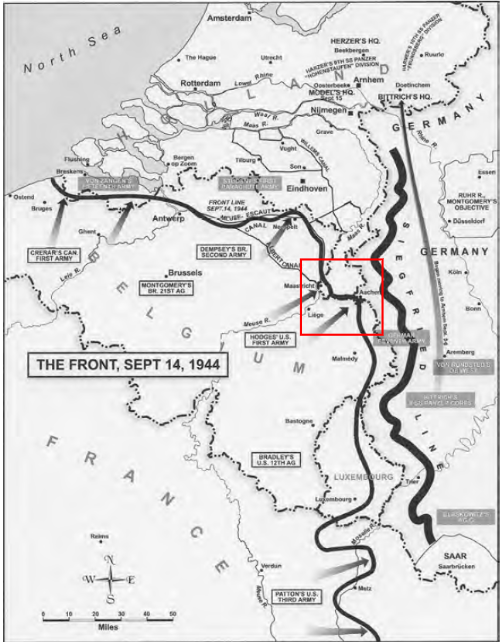
Map 1. Map of the Allied advance on the western front just before Operation Market Garden. Located in the red box is General Hodge’s First Army that participated in the Battle of Hürtgen Forest (Newland & Chun, 2011).
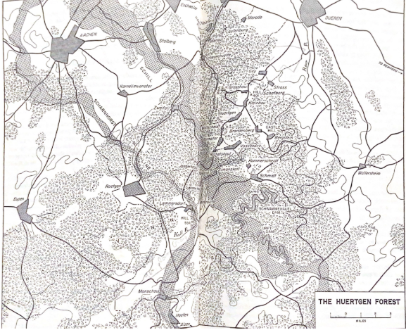
Map 2. This map shows an overview of the Hürtgen Forest. Notice the Roer river on the eastern side of the map and the dams in the southwest. The map highlights the limited road network that went through the forest. The quality of this map is a little poor since it was scanned from a book (MacDonald, 1963).
References
Drea, E. J. (1983). Unit Reconstitution - A Historical Perspective. Combat Studies Institute, Fort Leavenworth, Kansas. Retrieved May 1, 2021, from https://www.armyupress.army.mil/Portals/7/combat-studies-institute/csi-books/UnitReconstitution.pdf.
MacDonald, C. (1963). The Battle of the Huertgen Forest. (1st ed.). Lippincott.
Miller, E. G. (1995). A Dark and Bloody Ground: The Hürtgen Forest and the Roer River dams, 1944-1945. College Station: Texas A & M University Press.
Newland, S., & Chun, C. (2011). The European Campaign: Its Origins and Conduct (pp. 271-304, Rep.). Strategic Studies Institute, US Army War College. Retrieved February 19, 2021, from http://www.jstor.org/stable/resrep12096.12.
Snow, S MAJ. (1984). CSI Battlebook 11-A: Huertgen Forest – Offensive, Deliberate Attack, Forest. Combat Studies Institute, Fort Leavenworth, Kansas. Retrieved February 19, 2021.
About the Creator
Sam Shroyer
I am an active-duty Engineer Officer in the US Army with a BS in Environmental Engineering from West Point. My previous positions include the following:
- Assistant Training Officer
- Sapper Platoon Leader
- Company Executive Officer
Enjoyed the story? Support the Creator.
Subscribe for free to receive all their stories in your feed.
Comments
There are no comments for this story
Be the first to respond and start the conversation.