Places
Baiae: The Sunken City of Roman Splendor
Off the western coast of Italy, beneath the azure waters of the Tyrrhenian Sea, lies a submerged treasure—a testament to the lavish lifestyle and opulence of ancient Rome. Baiae, once a playground for Roman elites including Julius Caesar, Nero, and Hadrian, was renowned for its luxurious villas, thermal baths, and temples. This sunken city, hidden for over 1,700 years following the eruption of Mount Vesuvius in 79 AD, offers a captivating glimpse into the grandeur and indulgence of Roman society. A Retreat for Roman Elites In its prime, Baiae was more than just a coastal resort; it was a symbol of wealth and power. Located near Naples in the Bay of Naples, Baiae boasted a mild climate, natural hot springs, and stunning views of the Mediterranean—a perfect setting for the leisure pursuits of Rome’s elite. Emperors, senators, and wealthy patricians flocked to Baiae to escape the hustle and bustle of Rome, seeking relaxation, entertainment, and social connections. The city’s allure extended beyond its natural beauty. Baiae was adorned with luxurious villas, adorned with frescoes, marble statues, and intricate gardens. Thermal baths fed by natural hot springs offered therapeutic benefits and social opportunities, where political alliances were forged and intrigues unfolded. Baiae was not only a retreat but also a place of political maneuvering and cultural exchange, where the elite displayed their wealth and influence. Cultural and Historical Significance Baiae’s significance in Roman history is underscored by its association with prominent figures of the era. Pliny the Younger, a notable Roman writer and administrator, maintained a villa in Baiae and documented its splendor in his letters. The city’s popularity peaked during the first centuries AD, reaching its zenith under Emperor Hadrian, who expanded and embellished Baiae’s infrastructure, including its renowned imperial villa. The eruption of Mount Vesuvius in 79 AD, which famously destroyed Pompeii and Herculaneum, also affected Baiae. While not as catastrophically devastated as its nearby neighbors, Baiae experienced seismic activity and gradual subsidence, causing portions of the city to sink below the sea level over time. The gradual submergence, coupled with centuries of geological changes, transformed Baiae from a bustling resort city into an underwater archaeological marvel. Rediscovery and Archaeological Exploration Baiae’s submerged ruins were rediscovered in the 20th century, sparking renewed interest in its history and architecture. Archaeological expeditions have unearthed and studied remnants of Baiae’s grandeur, revealing intricate mosaics, marble columns, and remnants of opulent villas and temples. These discoveries have provided valuable insights into Roman urban planning, architectural techniques, and the daily lives of its affluent inhabitants. One of the most significant discoveries in Baiae is the Villa Protiro, an imperial residence believed to have belonged to Emperor Claudius. The villa’s luxurious design and extensive thermal complex exemplify the wealth and sophistication of Roman aristocracy. Excavations have revealed terraces overlooking the sea, elaborate frescoes depicting mythological scenes, and intricate hydraulic systems that regulated the flow of water throughout the complex. Preservation and Tourism Today, Baiae continues to fascinate archaeologists, historians, and tourists alike. The sunken city’s preservation beneath the sea has protected its ruins from centuries of terrestrial decay, offering a remarkably well-preserved snapshot of Roman life. Protected marine parks and conservation efforts ensure that Baiae’s underwater treasures remain accessible for scientific study and cultural appreciation. Visitors to Baiae can explore its submerged ruins through snorkeling, scuba diving, or glass-bottom boat tours, marveling at the ancient streets, submerged columns, and remnants of once-grand villas. The experience of discovering Baiae’s underwater world is akin to stepping back in time, where the echoes of Roman voices and the whispers of history resonate through the sunlit waters. Conclusion: Baiae’s Enduring Legacy Baiae stands as a poignant reminder of the heights of Roman luxury and the impermanence of human achievements. Once a vibrant hub of Roman society, it now lies beneath the waves, its opulent villas and grand temples preserved in an aquatic embrace. The sunken city of Baiae invites us to contemplate the passage of time and the resilience of cultural heritage, offering a profound connection to the past and the enduring allure of ancient Rome. As the waters of the Tyrrhenian Sea gently lap against its submerged ruins, Baiae continues to captivate and inspire, beckoning adventurers and historians to explore its hidden depths. Its story, from imperial retreat to archaeological marvel, serves as a testament to the enduring legacy of one of history’s greatest civilizations—a legacy that remains eternally preserved beneath the waves of time.
By Deji Akomolafe2 years ago in History
Ancient Egypt’s Wonders
In the golden age of ancient Egypt, where the mighty Nile carved life into the desert, and the gods themselves seemed to walk among men, the kingdom was a land of wonders, curiosities, and untold secrets. Imagine a land where colossal stone structures reached for the heavens, shimmering under the scorching sun, while deep beneath the sands lay treasures that glittered with the promise of eternal life.
By Merit Neith2 years ago in History
Atlit Yam: A 9,000-Year-Old Window into the Neolithic Past
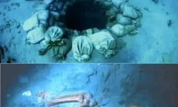
Submerged beneath the waters off the coast of Atlit, Israel, lies one of the most remarkable archaeological discoveries of our time: Atlit Yam, a 9,000-year-old Neolithic village. This ancient settlement, now resting 8 to 12 meters underwater, provides a detailed glimpse into the lives of people during the final Pre-Pottery Neolithic period, which dates back to between 6900 and 6300 BC. Atlit Yam, which spans around 10 acres, is not only an impressive testament to human ingenuity and survival but also a treasure trove of information about early agriculture, freshwater management, and social structures. Discovered in 1984, the site is an extraordinary reminder of the dynamic relationship between human civilization and the natural world. Submerged due to the post-glacial sea level rise following the last Ice Age, Atlit Yam lay hidden for millennia until underwater archaeologists began uncovering its secrets. The site has since revealed a rich array of artifacts, human remains, and stone structures that speak volumes about life in this early farming community. The Structures of Atlit Yam One of the most fascinating aspects of Atlit Yam is its well-preserved stone structures. Archaeologists have uncovered stone-built houses, offering insights into how people in the Neolithic period constructed their dwellings. These houses, typically circular or rectangular in shape, were likely built with wood and stone, reflecting a relatively advanced level of architectural knowledge for the time. Perhaps more remarkable than the houses are the wells found at the site. Atlit Yam contains some of the earliest known water wells, suggesting that the inhabitants had developed sophisticated methods for managing freshwater resources. The wells, some of which reach depths of up to five meters, were crucial for accessing fresh drinking water and irrigation for crops. The presence of these wells highlights how the people of Atlit Yam adapted to their environment and managed their resources, ensuring a stable water supply even in times of scarcity. A particularly intriguing feature at the site is a semi-circular arrangement of large stones surrounding a spring. The purpose of this structure is still debated, but some archaeologists believe it may have served a ritualistic or symbolic function, possibly related to water, fertility, or seasonal cycles. The fact that the stones were deliberately placed suggests that Atlit Yam’s inhabitants had a deep understanding of their environment and may have incorporated spiritual or cultural beliefs into their daily lives. A Glimpse into Neolithic Life The discovery of more than 100 human skeletons at Atlit Yam has provided invaluable insights into the health, diet, and lifestyle of its people. These skeletons show evidence of various medical conditions, including some of the earliest known cases of tuberculosis. The presence of such diseases suggests that as people transitioned from a nomadic, hunter-gatherer lifestyle to a more settled, agricultural way of life, they became more vulnerable to certain health issues due to living in close quarters and interacting more with domesticated animals. Examinations of the skeletons have revealed that the people of Atlit Yam had a diet rich in both plant and animal-based foods. Animal bones found at the site indicate that they hunted wild animals and also domesticated certain species, such as sheep and goats. In addition to hunting, they practiced early forms of agriculture, cultivating crops like wheat and barley. The presence of flint tools, sickle blades, and arrowheads further supports this, indicating that the community was engaged in both farming and hunting activities. Interestingly, the preservation of organic materials, including plant remains and animal bones, has allowed researchers to reconstruct the environment of Atlit Yam. The site’s inhabitants lived in a coastal region that likely provided access to a variety of resources, from marine life to terrestrial animals and plants. The presence of marine shells and fish bones at the site points to the importance of the sea as a food source, as well as a cultural element in their daily lives. Burial Practices and Social Structure The human remains discovered at Atlit Yam also provide clues about the community’s burial practices. Many of the skeletons were found in graves, some of which contained personal items like tools or ornaments. This suggests that the people of Atlit Yam placed importance on burying their dead with care and may have believed in an afterlife or spiritual continuation after death. The arrangement of bodies in certain burial patterns hints at a complex social structure, where certain individuals may have held higher status or had specific roles within the community. Additionally, the discovery of artifacts such as flint tools and polished stone axes suggests that the people of Atlit Yam were skilled craftsmen. These tools were essential for everyday tasks like hunting, farming, and building, but they may have also held symbolic or ritual significance. The presence of finely crafted tools and ornaments indicates that the community may have engaged in trade or exchange with other nearby groups, sharing goods, ideas, and cultural practices. The Legacy of Atlit Yam Atlit Yam stands as a remarkable testament to human adaptability and innovation. The people who lived there were among the first to transition from a nomadic lifestyle to one based on agriculture and permanent settlement. Their knowledge of architecture, freshwater management, and tool-making demonstrates a level of sophistication that was ahead of its time. Today, Atlit Yam is not just an archaeological site; it is a time capsule of Neolithic life. The artifacts and remains found there provide a vivid picture of how early humans lived, worked, and interacted with their environment. As researchers continue to study the site, new discoveries are likely to shed even more light on this fascinating chapter of human history. The village’s submersion, while tragic in its time, has also preserved it in a way that allows us to explore the rich tapestry of life from 9,000 years ago, helping us to understand the origins of human society in a world vastly different from our own.
By Deji Akomolafe2 years ago in History
Achilles: The Greatest Warrior of Greek Mythology
Achilles, a demigod born to a sea nymph and a king, is celebrated as one of the greatest warriors in Greek mythology. His early life was marked by extraordinary training under the centaur Chiron, who taught him the arts of hunting, music, and medicine. Achilles’ closest companion since childhood was Patroclus, a mortal without divine lineage or prophetic destiny. Despite their differences, the bond between Achilles and Patroclus was unbreakable, rooted in unconditional love. https://luglawhaulsano.net/4/8149800
By DANIEL AKAM OKO2 years ago in History
Dunster: A Journey Through Time in Somerset's Medieval Village
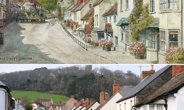
Nestled in the heart of Somerset, England, lies the quaint and remarkably well-preserved medieval village of Dunster. Known for its rich history, picturesque setting, and enchanting charm, Dunster offers visitors a rare opportunity to step back in time and experience life in a village that has remained largely unchanged for centuries. Boasting over 200 listed buildings, Dunster is not only an architectural treasure trove but also a living monument to England’s medieval past. At the center of the village stands the High Street, the bustling main road that has been the lifeblood of Dunster for centuries. Painted in 1900 by local artists, the High Street of that time looks almost identical to what visitors can see today, a testament to the village’s dedication to preserving its heritage. Walking down the cobbled street, flanked by historic stone buildings, feels like traversing the pages of a history book, with every step revealing a new layer of Dunster’s storied past. A Village Frozen in Time Dunster's medieval heritage is immediately apparent from the moment you enter the village. The buildings, many of which date back to the 15th and 16th centuries, are stunning examples of medieval and early-modern architecture. From half-timbered houses to stone cottages, Dunster’s streets are lined with a variety of historical structures that have been lovingly maintained over the years. At the heart of the village stands the imposing Dunster Castle, which has dominated the landscape since Norman times. Originally built as a motte-and-bailey fortress after the Norman Conquest, Dunster Castle has undergone several transformations over the centuries, evolving from a military stronghold into a lavish country home. Today, it is a popular tourist attraction, offering panoramic views of the surrounding countryside, as well as a glimpse into the lives of the aristocracy that once called the castle home. Just below the castle, on the edge of the High Street, lies the Yarn Market, a charming octagonal building that dates back to the late 16th century. Built by the Luttrell family, who owned Dunster Castle, the Yarn Market was originally used for trading wool and other goods, reflecting Dunster’s importance as a hub of the medieval wool trade. The building, with its distinctive timber-framed roof, is a rare and well-preserved example of a market hall from the period, and it remains one of Dunster’s most iconic landmarks. High Street: Then and Now While much of Dunster has changed over the centuries, its High Street has remained remarkably consistent in its appearance. A painting of the High Street from 1900 captures a snapshot of the village that is strikingly similar to what you would find today. The same stone buildings, with their sloping roofs and wooden window frames, still line the street, and the sense of history and continuity is palpable. Walking down the High Street, visitors can see a mixture of historic homes, shops, and inns, many of which have been converted for modern use while retaining their original charm. The Dunster Steep, the main thoroughfare leading into the village, is lined with Victorian-style street lamps and lush greenery, adding to the timeless feel of the village. With the Yarn Market at one end of the street and the majestic St. George’s Church at the other, the High Street serves as the heart of the community, just as it has for hundreds of years. One of the most notable features of the High Street is the Luttrell Arms Hotel, a historic inn that dates back to the 15th century. Once a medieval house, it was converted into a coaching inn and has since welcomed countless travelers over the centuries. The inn’s grand, stone façade and oak-beamed interior offer a glimpse into the luxurious accommodations once enjoyed by merchants and nobility. Today, the Luttrell Arms remains a popular destination for visitors looking to immerse themselves in Dunster’s rich history while enjoying modern comforts. Preserving Dunster’s Heritage The preservation of Dunster’s historic buildings is no accident. Over the years, there has been a concerted effort to protect the village’s unique character and heritage. Many of Dunster’s 200 listed buildings have been carefully restored, ensuring that the village retains its medieval charm while accommodating modern needs. These preservation efforts have helped Dunster become a popular destination for tourists, history enthusiasts, and artists alike. The village has also benefited from its location within Exmoor National Park, which has helped to shield it from overdevelopment and maintain its rural atmosphere. Surrounded by rolling hills and ancient woodlands, Dunster’s setting is as picturesque as the village itself. The proximity to natural beauty only enhances the appeal of the village, making it an ideal spot for walkers, cyclists, and those seeking a peaceful retreat. A Living History Dunster’s historical significance extends beyond its architecture. The village is a living history museum, with its traditions and customs carried forward by the local community. Throughout the year, the village hosts a number of events that celebrate its medieval roots, including the Dunster by Candlelight festival, where the village is illuminated by candles and lanterns, creating an enchanting atmosphere that transports visitors back to a time before electricity. Another event that draws visitors to Dunster is the Medieval Fair, where the village comes alive with costumed performers, traditional crafts, and medieval music. These events not only celebrate the village’s rich history but also help to keep it alive for future generations, ensuring that Dunster’s story continues to be told. Conclusion: A Timeless Treasure With its medieval architecture, well-preserved buildings, and rich cultural heritage, Dunster is a timeless treasure that offers a window into England’s past. The village’s High Street, much as it appeared in 1900, serves as the heart of this historical gem, a place where history is not just preserved but lived. Whether you’re exploring the ancient Dunster Castle, admiring the historic Yarn Market, or simply strolling along the cobbled streets, Dunster offers an unforgettable journey through time. In a world that is constantly changing, this medieval village stands as a reminder of the enduring beauty of history and the importance of preserving our cultural heritage for future generations.
By Deji Akomolafe2 years ago in History
Europe’s Oldest Road: A Minoan Engineering Marvel on the Island of Crete
Nestled on the picturesque island of Crete, amidst the ancient ruins of palaces and temples, lies a truly remarkable piece of history: Europe's oldest known road. Over 3,500 years old, this Minoan road stands as a testament to the engineering prowess of the Minoan civilization, one of the most advanced and influential cultures of the Bronze Age. Spanning approximately 50 kilometers, the road connected the great palace of Knossos—the political and ceremonial center of Minoan Crete—with the ancient cities of Gortyn and Lebena. While the Minoan civilization is best known for its art, architecture, and mythology, this ancient roadway offers a glimpse into the advanced infrastructure that underpinned Minoan society. Built around 1,500 BCE, the road was designed to facilitate trade, travel, and communication across the island. Yet, it wasn’t just the purpose of the road that was impressive; it was the construction itself—a marvel of ancient engineering that has withstood the test of time. The Ancient Minoans: Masters of Engineering The Minoans, who flourished from approximately 3,000 to 1,400 BCE, are widely regarded as the first advanced civilization in Europe. Based on the island of Crete, their influence extended throughout the Aegean Sea, with their art, architecture, and written language (known as Linear A) leaving a lasting legacy on the ancient world. The palaces of Knossos, Phaistos, and other Minoan cities were sophisticated centers of culture and commerce, reflecting the wealth and power of this seafaring civilization. However, one of the lesser-known aspects of Minoan society was their mastery of engineering, particularly in the construction of roads and infrastructure. The Minoan road that connected Knossos to Gortyn and Lebena is a prime example of this expertise. Long before the Roman Empire would become famous for its network of roads spanning Europe, the Minoans had already developed advanced techniques for building durable, long-lasting roads that could withstand the elements and heavy use. A Road Ahead of Its Time What sets the Minoan road apart from other ancient roads is its advanced construction. At first glance, it may seem like a simple pathway made of stone, but a closer examination reveals the intricate planning and innovative techniques that went into its creation. The road was designed not only for functionality but also for durability, with several key features that ensured its longevity. One of the most remarkable aspects of the road is the inclusion of side drains to manage water runoff. These drains were strategically placed along the edges of the road to prevent water from pooling on the surface, which could lead to erosion and damage over time. By directing water away from the roadbed, the Minoans were able to preserve the integrity of the road for thousands of years, ensuring that it remained passable even during heavy rains. The roadbed itself was composed of a 20-centimeter-thick layer of sandstone blocks, tightly fitted together and bound with a clay-gypsum mortar. This foundation provided a stable and strong base for the road, preventing it from shifting or sinking over time. On top of this foundation, the Minoans laid a layer of basaltic flagstones, which created a smooth, hard-wearing surface for travelers and traders to use. These flagstones, made from a volcanic rock that is both durable and resistant to wear, were carefully cut and fitted to ensure a smooth, even surface. The attention to detail in the road’s construction extended beyond just the surface. The road also featured separate shoulders—a rare inclusion for roads of this era. The shoulders provided extra space for carts, pedestrians, and livestock to move safely, ensuring that travel along the road was efficient and orderly. This shows a deep understanding of road design and traffic management, something that was highly advanced for the time. A Vital Link in Minoan Crete This Minoan road wasn’t just a technological marvel; it was also a vital link in the economic and social network of ancient Crete. Connecting the palace of Knossos with the cities of Gortyn and Lebena, the road played a crucial role in facilitating trade and communication between these key centers of Minoan civilization. Knossos, the largest and most important palace on Crete, was a hub of political and ceremonial activity. As the seat of the Minoan rulers, it attracted merchants, artisans, and diplomats from across the Mediterranean. The road leading from Knossos to Gortyn, another major city on the island, allowed for the exchange of goods, ideas, and people, helping to strengthen the economic and cultural ties between the two cities. From Gortyn, the road extended to Lebena, a port city that connected Crete to the wider Mediterranean world, facilitating trade with other Aegean islands and mainland Greece. The road also served a military purpose, enabling the rapid movement of troops and supplies between key locations on the island. In a time of constant regional competition and the need for defense, having a reliable road network was essential for maintaining control over Crete. A Legacy That Endures Today, more than 3,500 years after its construction, parts of the Minoan road can still be seen on the island of Crete. Although it no longer serves the bustling trade and communication needs of a Bronze Age civilization, it remains a powerful symbol of the Minoan people's ingenuity and skill. The road’s advanced construction, from its side drains to its tightly fitted sandstone blocks, is a reminder of the sophisticated engineering techniques that allowed it to endure through the millennia. As the oldest known road in Europe, the Minoan road on Crete represents more than just a physical path through the island’s rugged landscape—it stands as a testament to human innovation, resilience, and the timeless quest to connect communities and cultures. The Minoans may be long gone, but their road endures, a silent witness to the passage of time and the lasting impact of their civilization on the world. In many ways, the Minoan road was ahead of its time, laying the groundwork for the roads that would come later in the ancient world, including those built by the Romans. Its legacy lives on, not just in the stones that remain, but in the lessons it teaches us about the enduring nature of human ingenuity.
By Deji Akomolafe2 years ago in History
The Frankford Avenue Bridge: America’s Oldest Bridge Still in Use
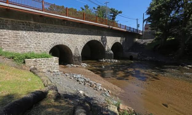
Tucked away in the bustling city of Philadelphia is a relic from a time long before the United States existed as a nation—the Frankford Avenue Bridge, also known as the King’s Highway Bridge. This unassuming stone structure, built in 1697, holds the distinction of being the oldest bridge in the United States still in use, predating the country itself by nearly 80 years. The bridge was erected to provide a crucial crossing over Pennypack Creek and remains an enduring symbol of American colonial engineering, quietly serving both local and modern traffic for more than three centuries. While its historical significance is profound, the Frankford Avenue Bridge is more than just a link to the past; it’s a testament to the ingenuity of early American settlers and the lasting impact of colonial infrastructure on modern-day America. As we take a closer look at the history of this bridge, we begin to understand how a simple structure can embody the ambitions, struggles, and achievements of a nation on the brink of formation. The Birth of the King's Highway Bridge Philadelphia, founded in 1682 by William Penn, quickly grew into one of the most important cities in colonial America. Situated on the Delaware River, the city became a hub for trade, commerce, and politics. By the late 1600s, the need for well-developed roads and bridges to facilitate travel and transport across the colonies was apparent. One of the most significant routes during this time was the King’s Highway, a major thoroughfare established to link the American colonies from Boston to Charleston. The King’s Highway was not only an essential route for trade but also a lifeline for the exchange of ideas, news, and culture among the scattered colonial settlements. However, many natural obstacles stood in the way of smooth travel along this road, including the Pennypack Creek, a waterway that winds through what is now northeast Philadelphia. To solve this problem, colonial settlers needed a bridge that would be sturdy enough to withstand the test of time, and so the Frankford Avenue Bridge was born. Completed in 1697, the Frankford Avenue Bridge was constructed using local materials and techniques common in 17th-century Europe, particularly England. The bridge is a three-span stone arch structure, with semi-circular arches supporting the roadway. Stone bridges were favored at the time for their durability, and the Frankford Avenue Bridge has certainly proven its resilience. Its stone arch design, combined with careful craftsmanship, has allowed it to remain in continuous use for over 300 years, weathering the storms of history and the development of a nation. A Colonial Crossroads The bridge was strategically built as part of the King’s Highway, which was vital for both colonial expansion and defense. This road connected cities, towns, and rural areas, enabling goods and services to flow between communities. As part of the larger transportation network, the Frankford Avenue Bridge played a key role in facilitating commerce by allowing traders and merchants to cross the Pennypack Creek without difficulty, thereby connecting Philadelphia with other parts of Pennsylvania and the broader colonies. During the colonial era, roads were often treacherous and difficult to navigate, especially after heavy rains or during the winter months when creeks and rivers would swell. The construction of the bridge was a significant improvement in the infrastructure of the time, providing a stable, reliable route for horse-drawn wagons and travelers on foot or horseback. This enhanced the speed and efficiency of transportation, helping to bolster the local economy. Moreover, the bridge was part of the King’s Highway, which was not only a commercial route but also one used by the colonial government for military purposes. Troops, officials, and couriers regularly traveled along this highway, especially as tensions between the American colonies and Britain escalated in the years leading up to the Revolutionary War. The bridge, thus, witnessed a significant amount of historical activity, standing as a silent witness to the changing political and social landscape of early America. An Enduring Legacy What makes the Frankford Avenue Bridge truly remarkable is not only its historical importance but its longevity. In an era when most man-made structures are replaced within decades, the Frankford Avenue Bridge has survived for more than three centuries. Its original stone arch construction has held strong despite the demands of modern transportation. While the bridge has undergone several repairs and renovations over the years to maintain its structural integrity, its core design remains largely unchanged. Today, the Frankford Avenue Bridge continues to serve as an active roadway, carrying vehicles, pedestrians, and cyclists over the Pennypack Creek. Despite its age, the bridge is still a functional part of Philadelphia’s infrastructure, seamlessly blending the old with the new. It stands as a reminder of the city’s deep colonial roots and the enduring nature of the infrastructure that early settlers put in place. Historical Recognition and Preservation Recognizing its historical and architectural significance, the Frankford Avenue Bridge was added to the National Register of Historic Places in 1988. This designation ensures that the bridge will be protected and preserved for future generations, safeguarding its legacy as one of the country’s most important historical structures. The bridge also holds a special place in the hearts of local residents, who take pride in the fact that they are connected to such a rich piece of American history. Efforts to preserve the bridge have been driven by both local and national interest, with historians and engineers working together to ensure that the structure remains safe for use while retaining its historical character. Despite its age, the bridge has been carefully maintained to accommodate modern traffic demands, a testament to the skill of its original builders and the value placed on its preservation. Conclusion: A Bridge Between Eras The Frankford Avenue Bridge stands as more than just a physical structure—it is a bridge between eras, connecting the present to the colonial past. Built in 1697, during a time when America was still under British rule, this stone arch bridge has withstood the test of time, continuing to serve the city of Philadelphia as it has for over 300 years. As the oldest bridge in the United States still in use, it is a powerful reminder of the enduring legacy of colonial infrastructure and the vital role such structures have played in shaping the nation we know today. In a city known for its historical significance—home to the Liberty Bell, Independence Hall, and countless other landmarks—the Frankford Avenue Bridge holds its own as a quiet yet monumental symbol of America’s early history and the remarkable feats of engineering that have stood the test of time.
By Deji Akomolafe2 years ago in History
The Road to Success
Success is rarely a straight path. It is often fraught with challenges, setbacks, and moments of doubt. Yet, it is through these trials that the seeds of greatness are sown. The stories of those who have achieved remarkable success are not just tales of triumph, but also of unwavering perseverance and resilience. This article delves into true stories of individuals who exemplified these qualities, ultimately achieving their dreams and inspiring others along the way.
By Sazeeb Chowdury2 years ago in History
The Human Statue of Liberty: A 1918 Patriotic Tribute Formed by 18,000 Soldiers
In 1918, a powerful and unusual tribute to American ideals was made—not in stone or metal, but in human form. At Camp Dodge in Des Moines, Iowa, an astonishing scene unfolded: 18,000 soldiers stood in formation to create a living, breathing replica of the Statue of Liberty. This remarkable human sculpture, captured in a famous photograph, symbolized not just the nation’s enduring values of freedom and democracy, but also the collective strength and unity of the United States during one of the most challenging times in its history: World War I. A Nation United in Wartime The year 1918 was a critical time for the United States and the world. World War I, also known as “The Great War,” had ravaged Europe for four years, and the United States had joined the conflict in 1917. The country’s military forces were undergoing rapid expansion to meet the demands of the global conflict. Across the U.S., military camps were established to train soldiers who would be sent overseas to fight in Europe. Camp Dodge, located near Des Moines, Iowa, was one of these training grounds, where thousands of young men prepared to defend the ideals their country held dear. It was during this tumultuous time that the famous human Statue of Liberty was created. This act of patriotic artistry served as a symbol of national unity, freedom, and the commitment of American soldiers to fight for liberty on foreign shores. The Vision Behind the Human Statue of Liberty The idea of creating the Statue of Liberty using human bodies was the brainchild of Arthur Mole, a British-born American photographer known for his innovative work with large groups of people. Mole specialized in what he called "living photographs," where he arranged thousands of people into elaborate shapes or symbols that were visible only from a certain height. His work was a combination of military precision, artistic vision, and a deep sense of patriotism. Mole worked alongside his collaborator John D. Thomas to bring this ambitious project to life. Their goal was to use the bodies of soldiers to create an enormous depiction of the Statue of Liberty, one of America’s most iconic symbols. The Statue of Liberty, given as a gift from France in 1886, had become a global representation of freedom, democracy, and the hope for a better life. During World War I, it also served as a reminder of what was at stake in the conflict: the preservation of liberty and the protection of democratic values. The Logistics of the Project Creating the human Statue of Liberty required careful planning and extraordinary coordination. Mole and Thomas had to arrange 18,000 soldiers into a shape that would resemble the statue when viewed from a specific vantage point. This process involved a painstaking level of detail, as the soldiers had to be positioned in such a way that they would form the lines, curves, and proportions of the statue’s features. The task required military discipline and cooperation, as each soldier played a critical role in forming the overall image. From above, the soldiers came together to create not only the outline of the Statue of Liberty, but also her torch, crown, and flowing robes. The precision required to make the image appear recognizable from an aerial perspective was nothing short of remarkable. The formation spanned over several acres of land at Camp Dodge, with the soldiers arranged in different layers to create the necessary depth and detail. Those at the top of the formation, such as those forming the flame of the torch, were positioned much closer together, while those near the base of the statue were spread out more widely. This technique of perspective manipulation allowed the entire image to come together in a way that appeared natural when photographed from above. The Symbolism of the Human Statue of Liberty The human Statue of Liberty represented more than just a clever visual spectacle—it was a powerful expression of patriotism and solidarity during a time of war. In 1918, the U.S. was deeply involved in the global conflict, and the need to boost morale, inspire unity, and promote the values for which soldiers were fighting was paramount. The image of 18,000 men coming together to form the Statue of Liberty was a potent symbol of collective effort, sacrifice, and national pride. The soldiers in the formation were preparing to leave for the battlefields of Europe, where they would join the Allied forces in the fight against the Central Powers. The war had already claimed millions of lives, and these men were ready to risk everything to defend their country’s ideals. By forming the shape of the Statue of Liberty, they symbolized the unity and strength of the American people, as well as their willingness to defend the principles of freedom and democracy. The Legacy of the Human Statue of Liberty The photograph of the human Statue of Liberty has endured as a lasting symbol of America’s wartime unity and the collective power of its citizens. The image stands as a testament to the creativity and ingenuity that can emerge even in times of great hardship. It also highlights the role of art and symbolism in rallying people around a common cause. Arthur Mole’s living photograph was part of a series of similar works he created during World War I, including formations of the Liberty Bell, the American flag, and the U.S. Army insignia. These images were widely distributed and used in propaganda to inspire patriotism and support for the war effort. Today, they serve as a reminder of the sacrifices made by those who served during the Great War and the enduring power of collective action. Conclusion The human Statue of Liberty created at Camp Dodge in 1918 remains one of the most striking and memorable images of the World War I era. Formed by 18,000 soldiers standing in perfect formation, it symbolized the unity, strength, and dedication of the American people in a time of great turmoil. The ingenuity behind the project, combined with the deep symbolic meaning of the Statue of Liberty, made it a powerful expression of patriotism and a lasting tribute to the men and women who fought for freedom during the Great War. Today, the image continues to inspire awe and serve as a reminder of the collective strength of a united people.
By Deji Akomolafe2 years ago in History
Top 10 Historical Sites in Egypt You Can’t Miss
Egypt is a land of ancient wonders, filled with historical sites that capture the imagination. From monumental pyramids to exquisite temples, these sites tell stories of a rich and fascinating past. Here’s a closer look at the top 10 historical sites in Egypt you can’t miss.
By Visit Egypt2 years ago in History
Magic at the River's End
**Where the River Meets the Sea** In a quaint coastal town nestled between rolling hills and shimmering azure waters, there was a river that flowed gracefully through the heart of the community. It carried with it stories of times gone by and whispers of dreams yet to be realized. This river, known as Serenity Creek, wound its way through meadows and ancient forests before finally reaching the vast expanse of the sea.
By Saheed AbdulQodir Oladimeji2 years ago in History