Do We Possess an Accurate MapOf The Earth?
Exploring the Quest for a Precise Representation of Earth's Geographical Reality

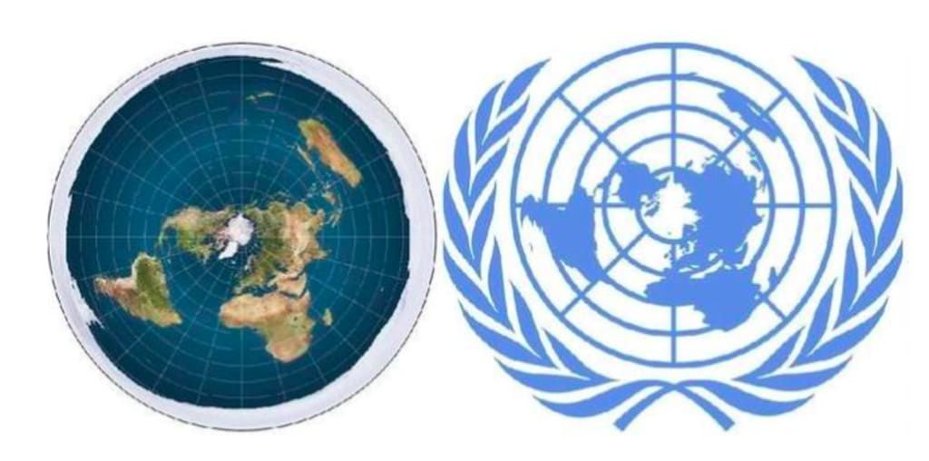
A challenge within the flat Earth perspective revolves around the absence of an accurate flat Earth map. A parallel can be drawn with the globe, where a true map doesn't exist due to the inherent three-dimensional nature of a globe, making it impossible to perfectly translate onto a two-dimensional surface. Consequently, various projections are used to represent the globe as a flat map. However, if the Earth were indeed flat, constructing a precise map should theoretically be straightforward. Strangely, flat earthers encounter difficulty producing a comprehensive and accurate map. In debates, proponents of the round Earth theory, like Fight the Flat Earth (FtFE), often request flat earthers to present an accurate map, but these requests are typically deflected.
One instance involved a debate between FtFE and a flat earther named Flat Zoid, focused on celestial navigation. During the debate, Flat Zoid argued that accurate flat Earth maps exist. FtFE raised the question, questioning the absence of an accurate map that displays countries' sizes correctly. Despite this, the debate appeared to evade addressing this specific issue.
It's perplexing why flat earthers struggle to provide such a map. While maps inherently involve simplification, a comprehensive and accurate flat Earth map should be feasible if the Earth is truly flat. This contrasts with established round Earth maps, where measurements and distances between points can be translated accurately using scales. Flat earthers' challenges to address this map issue underscore the difficulties in reconciling their theory with empirical evidence.
This discussion also highlights the significance of accurate maps in illustrating geographic information and facilitating navigation. While various map projections exist for round Earth representation, they are consistent in conveying accurate measurements. In contrast, the inconsistencies in flat Earth maps pose challenges for creating a unified and accurate representation.The challenge with the flat Earth viewpoint lies in the absence of a single accurate flat Earth map that maintains consistent scale and accurately represents distances between all points. If the Earth were indeed flat, it should be feasible to create such a map with accurate distances throughout. A counterpoint from flat side suggests that while the Mercator map, which is a projection of the globe, isn't entirely accurate, nautical charts are precise, and these are based on the Mercator map projection. However, this raises the question of where an accurate flat Earth map is, especially for celestial navigation.
FtFE raises the concern that flat earthers struggle to produce an accurate map for celestial navigation. During a debate with Flat Zoid, the discussion delves into the accuracy of nautical charts. These charts can be precise but usually pertain to small areas, accommodating more detail like local tides and sea depths. However, the accuracy diminishes when attempting to create a comprehensive map of the entire world. The video also showcases historical maps and emphasizes that maps of the past weren't standardized, including the prime meridian placement, until relatively recently. The latitude and longitude grid systems we use today are relatively modern developments, added after the spherical Earth model was established. The argument also touches on the scale discrepancies in the Mercator map and its conversion measurements.
Overall, the discussion highlights the challenge in reconciling accurate maps with the flat Earth theory, considering both scale and distance consistency. It showcases how various maps have been developed historically and how modern grid systems like latitude and longitude have been integrated into the representation of the globe.
The grid boxes on the map lack consistency, as indicated by the measurements provided in the corner. For instance, when the equator aligns with the center of the screen, the longitude lines are stated to be approximately 2,000 kilometers apart. However, as we shift our position on the map, the measurement changes, with the distance between lines diminishing towards the Poles. This can be observed when zooming in on different regions of the world. Zooming in at the Equator reveals grid squares as small as 30 meters across, while at 45 degrees north or south, they reduce to 20 meters across. This trend persists at higher latitudes as well, with the lines barely two meters apart at 85 degrees north or south.
During a live stream, a viewer pointed out to Flat Zoid the discrepancy in scale when zooming in on different parts of the map. Flat Zoid responded by attributing the scale changes to the grid system, suggesting that it's accurate based on the observer's position. The counterargument presented is that an accurate depiction should maintain a consistent scale across all parts. For instance, models with fixed scales ensure that measurements remain proportionate. The issue with the map Flat Zoid presents is that it lacks this consistency.
A comparison is made to models on a shelf, which adhere to a uniform scale and maintain accuracy across the board. Conversely, when attempting to align and piece together different sections of the Open Sea map, distortions arise, indicating an absence of consistent scale. This inability to achieve a cohesive representation of Earth's sizes and distances underscores the challenge with flat Earth maps.
The discussion delves into the core problem: Earth's spherical nature is supported by the fact that measurements maintain consistency regardless of the points chosen on the globe. If Earth were flat, a projection would introduce distortions and inconsistencies, leading to varying measurements. This video concludes with an invitation for comments and encourages likes and subscriptions.
About the Creator
Enjoyed the story? Support the Creator.
Subscribe for free to receive all their stories in your feed. You could also pledge your support or give them a one-off tip, letting them know you appreciate their work.


Comments
There are no comments for this story
Be the first to respond and start the conversation.