
Content warning
This story may contain sensitive material or discuss topics that some readers may find distressing. Reader discretion is advised. The views and opinions expressed in this story are those of the author and do not necessarily reflect the official policy or position of Vocal.
Introduction:
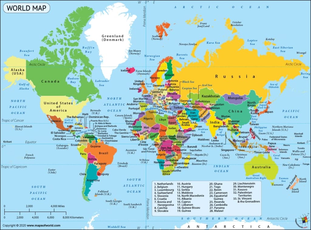
World maps are an essential tool for understanding our planet's geography and exploring its vast diversity. The design of a world map involves a delicate balance between accuracy, aesthetics, and purpose. This article explores the intricate process of creating world maps, delving into the artistry and scientific principles that shape their design. The world map consists of numerous countries, each with its own unique geographical location. The importance of a country's location can vary based on several factors, including strategic, economic, political, and cultural considerations. Here are some examples:
Strategic Importance: Some countries possess a strategic location that provides them with significant advantages in terms of defense, trade, or regional influence. For instance:
The United States: Its location between the Atlantic and Pacific Oceans allows it to project power globally and facilitates trade between the eastern and western hemispheres.
Russia: Its vast territory spans both Europe and Asia, providing strategic depth and control over critical transportation routes.
Economic Significance: Countries with advantageous geographic positions often enjoy economic benefits, such as access to key trade routes or abundant natural resources. Examples include:
Singapore: Positioned at the southern tip of the Malay Peninsula, it serves as a major global trade hub and a crucial gateway between the Indian Ocean and the South China Sea.
Saudi Arabia: Its location in the Middle East, with extensive oil reserves, gives it substantial influence in global energy markets.
Political Considerations: Some countries hold significance due to their location in politically sensitive regions, which can impact regional stability and international relations. For instance:
Israel: Situated in the Middle East, it has been a focal point of geopolitical conflicts due to its proximity to other countries and its historical and religious significance.
North Korea: Located on the Korean Peninsula, it has drawn global attention due to its isolated position, nuclear ambitions, and tensions with neighboring South Korea and other nations.
Cultural and Historical Relevance: Certain countries possess locations that hold cultural, historical, or religious significance, attracting tourists and shaping regional identities. Examples include:
Egypt: Home to iconic historical sites like the pyramids and the Nile River, it attracts tourists from around the world, contributing to its economy.
Italy: Situated in the heart of the Mediterranean, it has played a central role in European history, art, and culture, drawing millions of visitors annually.
It's important to note that the importance of a country's location can change over time, depending on shifts in global politics, technology, and economic dynamics. Additionally, countries often have multiple factors contributing to their overall importance beyond just their geographical location.
Purpose and Projection:
The first step in designing a world map is determining its purpose. Different maps serve different needs, whether they are for navigation, educational purposes, thematic representation, or artistic expression. Once the purpose is defined, a suitable map projection is chosen. Map projections transform the three-dimensional Earth onto a two-dimensional surface, and each projection has its own set of strengths and distortions that must be considered.
Geographic Accuracy:
Geographic accuracy is crucial when designing a world map. Modern maps are typically based on accurate geospatial data obtained through satellite imagery and advanced surveying techniques. Cartographers strive to represent landmasses, coastlines, oceans, and other geographic features as faithfully as possible, while also accounting for inevitable distortions caused by the projection.
Symbolism and Representation:
Beyond accuracy, world maps often incorporate symbols and colors to convey additional information. Political maps, for example, use different colors or patterns to depict countries and their borders. Thematic maps may employ various symbols to represent population density, climate zones, or economic indicators. The choice of symbols and colors can significantly impact the message and readability of the map.
Layout and Typography:
The layout and typography of a world map play a vital role in its readability and visual appeal. Cartographers carefully position labels for countries, cities, rivers, and other landmarks to avoid clutter and ensure legibility. Font styles and sizes are chosen to complement the overall design and enhance readability, especially for smaller map details.
Cartographic Design Elements:
World maps incorporate various design elements to enhance their visual appeal and user experience. These elements include borders, legends, scales, grids, and compass roses. Borders help define countries and regions, while legends explain the symbols and colors used on the map. Scales indicate the relationship between distances on the map and the actual Earth, while grids and compass roses aid in orientation and navigation.
Evolving Map Design:
World map design continues to evolve as technology advances and new perspectives emerge. With the advent of digital mapping tools, interactive and customizable maps have become increasingly popular. Satellite imagery, augmented reality, and virtual reality are also reshaping how we visualize and interact with maps, allowing for immersive exploration of the world's geography.
Conclusion:
Designing a world map is a blend of science and artistry, requiring a deep understanding of geography, cartography, and human perception. It involves making conscious decisions about projection, accuracy, symbolism, layout, and design elements to create a map that is both informative and visually engaging. As technology progresses, the future of world map design holds exciting possibilities for more immersive and interactive experiences, enriching our understanding of the world we inhabit.
About the Creator
The charm of sunset on the beach
In the afternoon is the right time to visit the beach, enjoy the beauty of the beach with its stunning appearance and can spoil the eyes of the beholder. With the charm of the sun that will set after giving light to the world all day, adding to the beauty of the beach charm that is unmatched. Sitting relaxed on the beach can refresh the mood and mind after tired of all day activities.
By Rozi Atifah Nurabout 7 hours ago in Earth
Revolutionary Climate Action
In the retrospect of my childhood, the memories of the visits to the farm with my parents are a mixture of useful advice and interesting traditions. From my grandpa's idea of planting sweet potatoes underneath rocks to my grandmother's statement that we should plant fruit according to the moon cycles, to my dad's funny invention to control the wind during the rice or cocoa sifting, all these practices were both the usual and the interesting to me. Gradually, I began to think about these habits, it made me to think where they came from and how useful they are. My family usually avoided the cultural traditions which they considered as those which they called the eccentricity of my grandparents. However, my professional career was the climate crisis, where I now, as a consultant, help farmers to set up the resilient agroforests. The road that I have traveled has pushed me to start the Cacua Project, a project that is centered on the creation of the agroforests that are resilient and the collaboration between the farmers to the ecosystems management. Hence, I have combined the old knowledge with the modern research, which has a concrete aspect that deals with the climate change. I have gradually come to the conclusion that the old stories and practices handed down from generation to generation are the most beneficial. The partnering with the farmers, we conducted the experiments that verified some of the traditional methods. In addition, the rocks placed under the crops facilitated the drainage and at the same time it drew the good organisms. The method of planting by moon cycles turned out to be successful in the organization of irrigation and pollination by being in sync with the natural insect activity and the water cycles. Even the wind-whistling technique appeared to influence the air, therefore it was beneficial in the agricultural work. The jewels of wisdom which were taught by the ancestors to us are the ones that gave us the necessary tips for the better way of landscape protection. Ever since I was a young environmentalist, I have been committed to several life choices that elude what I consider good for the planet.
By Wes Wesley7 days ago in Earth
Red Shelves
Death is a black hole. Think about it. A black hole is the corpse of a star, something once warm and bright, now come to the end of its life cycle. But some will argue that the cycle of life does not end with death. That death is merely another path we must walk once our bodies expire and our souls ascend. In that moment, when the fuel in the star’s chemical tank hits empty and the shiny matte coat explodes into supernova, the mass left behind – the corpse – becomes a black hole. We understand that, around such a vast cadaver, dimensions work a little differently in death to the way we’re used to in life. For example, light cannot escape the pull of a black hole when it hits the point of no return. That’s where it gets its colour. Space itself is contorted by a black hole. That’s where it gets its funny shape. Even time. Time slows right down the closer you get to it. The closer you get to a black hole. The closer you get to death.
By Matthew Curtis7 days ago in Humans


Comments
There are no comments for this story
Be the first to respond and start the conversation.