


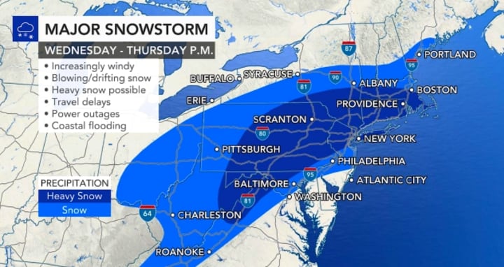
A major snowstorm is expected to sweep across much of the Northeast by midweek, unleashing the biggest snowstorm in years. Snowfall levels are expected to be measured in feet in some inland areas as winds flare up and create near-blizzard conditions for parts of the region from late Wednesday through Thursday morning.
But one factor will prevent the storm from becoming a real snow magnet, and that will be its forward speed. It will be a fast moving storm that will keep snow levels low overall. Even at the height of the storm, a snowfall limit of 1 to 3 inches per hour is expected.
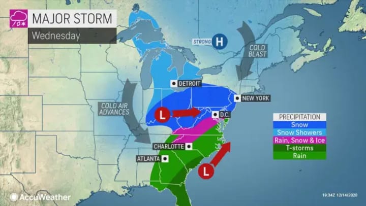
A fresh injection of cold air is already in place ahead of the storm. If Atlantic moisture is pulled into the storm off the coast on Wednesday, the storm will really kick off..
The National Weather Service issued warnings for winter storms for eight states from North Carolina to Massachusetts ahead of Tuesday's storm. More snow is expected from the developing storm than from all the storms of last winter combined in Washington, D.C., Philadelphia, New York City and Boston.
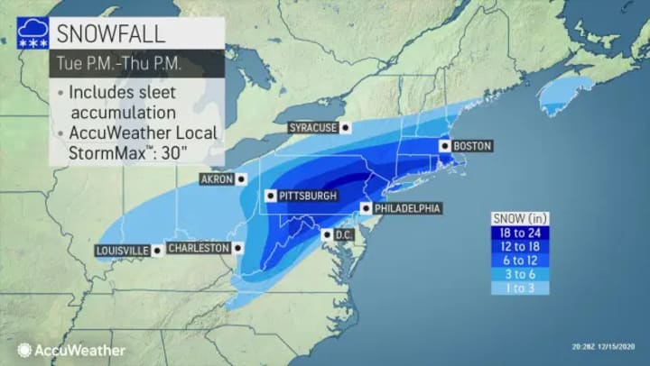
Precipitation will begin as snow in Baltimore and Washington, D.C., but a shift to a wintry mix will limit the total rainfall. D.C could see accumulations of 1 to 3 inches, and Baltimore is expected to increase 2 to 4 inches.
The mix will also reduce snow levels in Philadelphia, but the City of Brotherly Love could be buried under 4 to 8 inches of snow when the storm is over. That's more than the city saw throughout last winter, when only 0.3 inches of snow fell throughout the season.
It will also be tight in New York City, where snow is forecast to pile up to 6 to 12 inches. If snow changes earlier, the totals are closer to the lower end of the forecast. But if less rain mixes with snow in the Big Apple, a foot or more of snow is possible.
Harrisburg, Allentown and Scranton, Pa., are all likely to receive a foot or more of snow.
Boston, like New York City, will face some mix, and snowfall totals are expected to be in the range of 6 to 12 inches.
Forecasters warn the storm will strike hard and fast, with significant travel disruption and even travel shutdowns, as well as shipping delays, school closures and power outages caused by the blockbuster storm. Even where some students and people work from home during the storm, power outages could put a big dent in the plan. In some areas, not only could there be the heaviest snowfall in several years, but this snow could also match December snow records.
A wide swath of 12-18 inches of snow is expected to fall from northwestern Virginia and northeastern West Virginia to parts of northern Maryland, central and eastern Pennsylvania, northern New Jersey, southeastern New York State and southern New England. Within that area, some places might record 24 inches of snow with a local max of 30 inches.
Snowfalls of this volume will cripple travel and cause significant delays in deliveries at a time when critical distribution of COVID-19 vaccines has begun.
Heavy snowfall will cause snow to pile up quickly on the roads, increasing the risk of road closures and stranded motorists. It's strongly recommended that motorists be off the roads by the time the first flakes of snow start to fall. This will allow snow removal teams to work most efficiently.
The combination of heavy snow and gusty winds can create near-blizzard conditions just inland of the coast where all or most of the snow will fall from the storm. Northern New Jersey and the lower Hudson Valley of New York State, large parts of Connecticut and northwestern Rhode Island are the most likely areas to experience blizzard and whiteout. In this area, gusts of between 40 and 50 mph can occur frequently, which temporarily reduces visibility to near zero at the height of the storm from Wednesday night to early Thursday morning.
But further inland, where the snow will be dry and powdery and the wind will not blow as strongly, extensive drifts of snow are expected in addition to heavy snowfall.
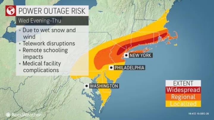
There is a chance of power outages and even minor tidal flooding due to strong winds on the coast.
The storm is expected to begin Tuesday night over parts of the Ohio Valley and southern Appalachians and spread through the central Appalachians and the mid-Atlantic during the day on Wednesday. The storm's effects will reach southern New England on Wednesday night.
Exactly how much snow falls along the corridor of Interstate 95 in the mid-Atlantic depends heavily on the exact path of the storm.
Further south, a swath of ice is expected to blanket parts of western North Carolina, upstate South Carolina and southwestern and central Virginia from late Tuesday night and into Wednesday. An ice glaze of 0.10 to 0.25 inches is projected.
In the midst of the ice storm that will hit sections of I-40, I-77 and I-81, roads can become extremely slick and travel should be avoided.
The storm should not last more than 24 hours in most places and will probably last only 12 hours in some places.
Wintry precipitation is expected to end Wednesday afternoon and evening over parts of the Ohio Valley and southern Appalachians, Thursday morning and noon over the Mid-Atlantic and central Appalachians, and finally Thursday afternoon and evening in New England.

A major blizzard is not expected over the Ohio Valley, but snowfalls of the order of 1-3 inches will make roads slippery in parts of southern Illinois, southern and central Indiana, much of Ohio and West Virginia.
Those who have dreamed of a white Christmas could get their wish this Christmas, even if the storm comes just a week or so before the holidays.
About the Creator
Buzzword
BuzzWord features, news, reviews and top ten lists.
Inshallah
Istanbul is a city bristling with life, a place where past and present, sacred and profane, intertwine under the watchful gaze of the Sultan Ahmet Mosque. As I explore this crossroads of cultures with Maya, my nine-year-old niece and the daughter of my late brother-in-law Frank, and my wife Nadia, Frank's sister, I find myself on a journey not just through Istanbul's history, but also into the depths of my own beliefs. Staying with Maya and her mother Elvan, my sister-in-law, I begin to see the city anew through their eyes, and to understand why James Baldwin said it "revived" him.
By Geoffrey Philp a day ago in Wander
The Invisble amongst us
"In January 2021, I was driving to see my mother at a local hospital. Traffic halted suddenly, and I was so happy I did not strike the vehicle in front of me. I gazed up in my rear-view mirror just as the vehicle behind struck my little sub-compact vehicle. "
By Bruce Curle `3 days ago in Psyche


Comments
There are no comments for this story
Be the first to respond and start the conversation.