


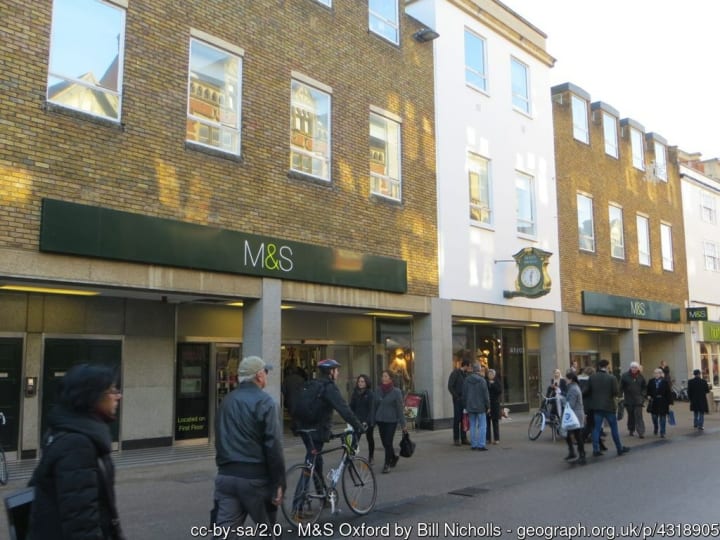
A murmuring throng, led by a rector and a red cassocked-choir, shuffles west along the narrow street on Ascension Day. Apart from the cleric, every member of the moving crowd holds aloft a withy of hazel five or more feet long as they make their way down Pembroke Street in the heart of Oxford.
As is the case with many old English streets, the road seems like an accidental route through a jumble of architecture; Regency jostles with crust-coloured Cotswold stone, while genuine, wonky, half-timbered houses from the reign of Elizabeth I rub along with turn-of-the-twentieth century Tudorbethan.
The crowd moves on and the road narrows towards its western end, suddenly widening again to allow a broad strip of tarmac to slope down into a delivery bay. Its surface is hatched by chevrons and yellow boxes as if the routines of the day are part of some grand, but intricately synchronised, board game.
As the flock reaches the delivery bay, it convenes around an awkward pause and, being British, the gathered townsfolk, choristers and clergy spontaneously arrange themselves into an orderly queue. They file through the rear door of Marks and Spencer, resembling nothing so much as a lynch mob on their way to a coffee morning. With as much solemnity as the circumstances allow, they make their way to the lingerie department.
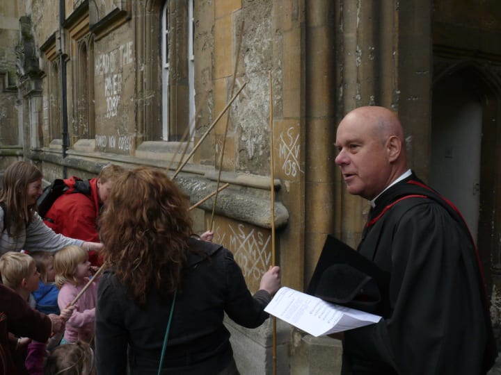
You could be forgiven for thinking that you have wandered onto the set of a mid 1970s sitcom, but no. After a short prayer, the rector of St Michael at the North Gate bends down with a stick of chalk amongst the shop fittings of St Michael of the bra and panties to mark a brass plaque on the floor with a cross and inscribes a letter in each quarter – S, M, N, G – whereupon the gathered crowd beat it with their hazel withies, crying, “Mark! Mark! Mark!”.
Folklorists scribble all of the details down and hope to find a semblance of rhyme or reason in the mélange of Christianity, superstition, paganism and civic pride
This peculiar scene, part of a ceremony called ‘beating the bounds’, has been played out for six centuries not only in this exact spot, but in thirty other locations around the city, along a route that follows the parish boundary. The rector himself spends considerable effort in writing to property owners to ensure access on the day and sometimes, where a new development might affect the site of a boundary stone – as was the case for the building of Marks and Spencer’s – planning applications are changed to take account of them.
The day eventually ends in a nearby college where all are encouraged to drink green ‘ivy beer’ and students throw hot pennies into the quad. A special gate is opened with the neighboring college, curious customs are played out and folklorists scribble all of the details down and hope to find a semblance of rhyme or reason in the mélange of Christianity, superstition, paganism and civic pride. The neighboring parish of St Mary the Virgin celebrates in similar style on the same day, even adding a hymn to the occasion though, as they do not share that part of their boundary with St Michael at the North Gate, a face-off between rival choristers in the lingerie section of Marks and Spencer is unfortunately out of the question.
A reflection of ancient ecclesiastical history still alive today, old boundary perambulations like this owe their origins partly not to what fate befalls you upon your death - as is usually the church’s fascination – but to one of life’s only other certainties, taxation. A few hundred years ago, the ecclesiastical parish levied its own taxes and which side of the parish line you lived in determined the size of the contribution you would have to make.
It is a scene that has remained the same throughout the ages; a 600 year-old tableau where the buildings move around, subject to planning conditions, and the actors change with time, but the characters they play and the lines they mark, those that divide the parishes, have barely changed. There are, however, fewer parishes now than there once were; in the case of St Michael at the North Gate which absorbed two other churches, the boundary has become so long that it takes three hours to complete the procession.
In rural parishes, where borders can be much longer than even the largest urban parish, the boundary is beaten in sections from one year to the next and can take several years to complete. At Helston in Cornwall, councilors accompanied by children from local schools and led by the town’s mayor, beat a third of the boundary each year on Ascension Eve, tramping through fields in a three hour walk that has been repeated every year since the reign of Elizabeth I. Before CoVID, only Helston’s famous Flora Day was deemed important enough to move Beating the Bounds to the following week and, then only if Flora Day happens to fall on Ascension Eve.
Each beating the bounds is a paean to the landscape, a ritual rooted, appropriately enough, in its own surroundings and with its own local form. In many, the youngest member or members of the gathered crowd are lifted and tipped upside down so that their heads can be gently knocked against a cushion or a turf laid upon the boundary stone.
If you think that that sounds odd, the willow or hazel withies that are used to beat the boundary stones of St Michael at the North Gate in Oxford may have once been applied against the youngest men of the parish instead as a reminder of the church’s moral as well as geographical boundaries. Taxes were not only collected, but spent by the vestry; responsibilities were fulfilled and the church liked to remind their parishioners of them – including the costs of care for children born out of wedlock. If young men couldn’t manage their own moral boundaries, the reasoning ran, then they should at least know where their geographical borders lay and look for women from other parishes for their amorous adventures.
So it is that the wayward route of St Michael at the North Gate’s boundary circumscribes the wayward behavior of its parishioners as much as it describes the parish border of its church. And it is far from the only instance of how a journey along a border tells a story about the people who are bounded as well as excluded by it.
Away to the south of Oxford, beyond the banks of the Thames and the Vale of the White Horse, you can follow the boundaries of the long parishes of the Lambourn Downs, each settlement arranged to run from the river valley on its alluvial clay and gravel terraces, up past the spring-line and on to the chalk down. A parish perfectly suited to fishing, grazing and arable, a microcosm of basic needs, each habitat an insurance against failure of another. These are places dedicated to the idea of community, where the first breaths of justice and accountability were nurtured in post-Roman Britain.
On Cuckhamsley Hill, above the downs village of East Hendred, on the Ridgeway path and next to its boundary with the parish of West Hendred, lies Scutchamer Knob - where King Cwichelm of Wessex was slain by King Edwin of Northumbria in 636 AD.
Once a conical mound but now abused and eroded into a horseshoe shape, the Knob is hidden among trees and perennially littered, since the 1990s, with beer bottles and party flotsam; its twentieth century reinvention as a rave venue a corruption of its Anglo-Saxon use as a meeting place or ‘shire moot’. Despite its later incarnation of party spot, there was probably more agony than ecstasy afoot at the Shire Moot – serious matters would be decided and criminals punished, with the well-named Kilman Knoll half a mile south at a lone Scots Pine, where the old packhorse trail crosses the boundary, being the favored spot for a local gallows.

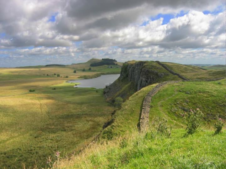
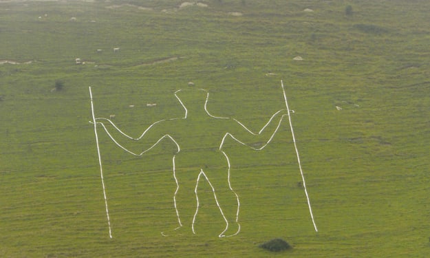
Morbid legends and gruesome secrets await any serious exploration of the landscapes of Southern England’s downs. Strung along the Ridgeway path of the Lambourn Downs, which forms the watershed boundary of the Kennet and Thames, prehistoric forts, round and long barrows and the Uffington White Horse are all part of a genuinely ancient landscape where the priorities of Neolithic and Bronze Age life are demonstrated in grand monuments that have all outlived their creators’ ambition on an epic scale.
Further south west, beyond the dip into the Kennet Valley lies the unforgiving escarpment of the Marlborough Downs where its natural rise and fall is interrupted by a scar across the landscape – Wansdyke. A linear rampart that stretches for miles in three sections across the top of Wessex, the identity of its architects is nowhere near as clear as its obvious historic purpose, that of a bulwark against free movement from the north. While other large structures often bear the personal names of kings and emperors – Hadrian’s Wall, Offa’s Dyke – Wansdyke was attributed to an even higher power, that of a Germanic god. Wans is a contraction of Woden’s – and, indeed, Wansdyke is known as Woden’s Dyke along some of its length – marking it out with a mythic origin that sets it apart in history. Wansdyke’s name suggests that rather than being built by Anglo-Saxons, it was merely named by them, rolling the date of its construction further in to the shadows of the Dark Ages that followed the Roman withdrawal from Britain in the early fifth century.
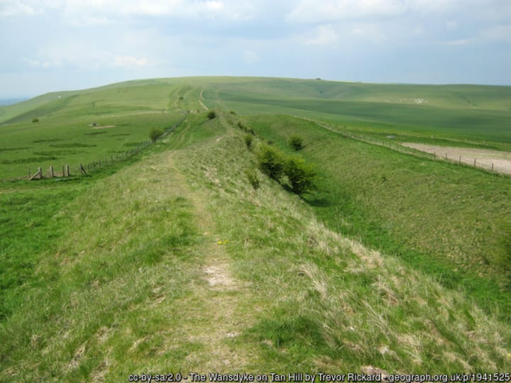
In parts, Wansdyke survives as a 13 foot-high bank with an 8 foot ditch on its northern side, but it must have been quite a sight when it stretched for over 35 miles across the downs of Wessex. Divided into three sections, west, east and a connecting middle section that runs along a section of Roman road, the eastern part is dated to the 5th or 6th century, while the western section is more loosely ascribed to a late Roman or post-Roman date. Woden, like his Norse counterpart Odin, was the patron god of boundaries, but Wansdyke, despite its size and former importance isn’t the frontier it once presumably was.
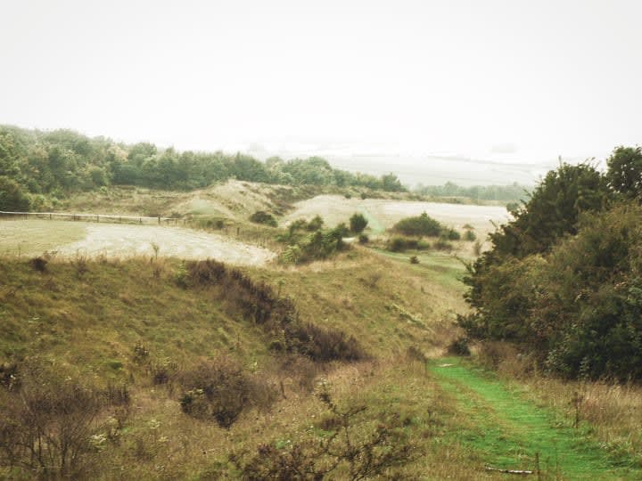
The same could also be said of Selwood Forest. A tangle of wild woodland at least as large as the modern remnants of the New Forest which formed an impenetrable shield, often a dozen miles thick, down the western side of Wiltshire from just south of Bath to Shaftesbury. When Wessex was expanding west into Dorset and Somerset, it was this line that protected the native Britons, pushed to the Celtic fringe. But the frontier was not complete; where it crossed the chalk downs of Cranborne Chase, southwest of the Saxon settlement of Searsbyrig, the vegetation was sparse, the ground was open and the Britons were vulnerable.
It was this open country that inspired the building of Bokerley Dyke a boundary so durable that it has lasted from ancient kingdom to modern local authority. Its current incarnation as a county boundary is the latest in a 3,000 year-long timeline that reveals interesting details about the history of the landscape it divides. Bokerley even had a part in a plan prepared in case of the ultimate dystopian future, the outbreak of nuclear war. A study of the Home Defence Regions – the administrative hierarchy by which survivors would be ruled if central government was destroyed – shows history up as a kind of repetitive motif extending into the future, with Bokerley Dyke once again part of an arrangement to divide the country into separate states along almost Anglo-Saxon lines.
All of which touches upon what a boundary is and what it is for. A border not only separates you from people on the other side of it, but also gives you a social identity, a sense of belonging and local pride. Over the centuries, your ancestors’ affiliation with a single parish or town has steadily widened into a social identity that has lost its over-powering local focus. You are a citizen not of a city, but a state and perhaps, even, a super-state. Where once you hailed from Compton Chamberlayne, Invergordon or Tal-y-Bont, now you are English, Scots or Welsh, also British, even European. Meanwhile, you identify with some other tribe that doesn’t necessarily have any geographical limitations – fans of Manchester United are, by and large, not from Manchester, lesbians aren’t necessarily from Lesbos and the influence of old Etonians doesn’t stop at the parish boundary of Eton, in much the same way as the influence of the inhabitants of neighbouring Windsor is unbounded. The world has moved on, but the borders remain and, as one of the most enduring features of Britain, they offer a hitherto unexplored facet that can unlock some of the secrets of the landscape.
Key parts of our history, therefore, are locked up in modern-day administrative conveniences like council boundaries precisely because ‘modern’ boundaries are often nothing of the sort. Dotted lines running across the landscape that today might seem inconsequential – drive across them regularly and perhaps you will notice a change in the quality of the tarmac or, in the case of county boundaries, subtle differences in the neon colour-way of police cars – but to a 14th century villager they were, for all intents and purposes, the edge of the known world.

Above: Islay
Complete freedom of movement was often enjoyed only by those opposite ends of society that were feared the most; the underclass, outlaws and itinerant traders, while the Anglo-Saxon ruling classes and the kings of Plantagenet and Medieval England, as well as their counterparts in Scotland, were much more mobile than we are used to now, holding court all over the country at early parliaments often held on marches and the no-mans-land of boundaries. The Shire Moot at Scutchamer Knob was one such place where moots were held close to the border. Others include an inaccessible island reached by a half-submerged causeway in Loch Tingwall on Shetland and a similar site on Loch Finlaggan on Islay are well documented locations, while on the edge of Anglo-Saxon Wessex, two tiny villages – Pentridge and West Woodyates, neither of which could even be remotely regarded as being at the centre of things – hosted the ‘Witenagemōt’, or Witan, the meeting of a Royal Council of wise, for which read ‘powerful’, men and women and the King they advised. This pattern of power being exercised from without the bounds was a feature of the exercise of authority for at least a thousand years.
It was certainly the case at Crockern Tor, just north of Two Bridges on Dartmoor, where the tin miners’ Stannary Court was held, adjacent to the ancient packhorse track that crossed the moor from east to west and at the junction of the moor’s four Stannary Districts. The Lord Warden of the Great Court of the Devon Tinners – Sir Walter Raleigh himself held the post from 1585 until his arrest in 1603 – sat on part of the tor known as Parliament Rock and conducted meetings to settle grievances and mete out punishment to those who had fallen foul of Stannary Law.

Above: Sir Walter Raleigh
While parishes and counties might have verifiably old boundaries, elsewhere, there are modern administrative divisions that shine a light on a prehistory so ancient that it makes the Bronze Age seem like last Tuesday. Among them are natural frontiers such as the Iapetus Suture, a line – some miles underground – along which three-billion year-old Scotland is welded to a much younger England. The line is all that remains of the Iapetus Ocean, crushed between the shorelines of two landmasses as they drifted together 400 million years ago to form a supercontinent with what was then the Himalayan-class Scottish Highlands at its heart. The suture is a geographical reality that almost exactly anticipated an abstract 800 year-old political boundary and the Act of Union that eventually followed it. Further south, the Great Whin Sill, upon which Hadrian’s Wall established the Roman Empire’s northern frontier, is the result of an episode of sub-surface volcanic activity in the Carboniferous period 300 million years ago.
There are yet more boundaries that follow obvious natural features such as streams and rivers, occasionally meandering along the line of a long-forgotten oxbow before rejoining the flow downstream, while most of Britain’s international borders – that is, our territorial waters, 12 nautical miles out to sea – are based on the mean low water mark; the mark itself is ultimately derived from two cataclysms, the floods of the North Sea and English Channel 425,000 and 200,000 years ago.
Other borders seem to be sociological constructs – in that they are abstract and intangible – but these, too, are based on a geographical reality. The Tees-Exe line or, to give it its popular name, the North-South divide, is a demarcation that follows the edge of the Jurassic outcrops along the 200 metre contour line and separates Britain into two simple zones, upland and lowland or north and south. These outcrops, which are composed of Cotswold limestones and the freestones of Bath and Portland, are the building blocks, appropriately enough, of ‘Middle England’; many of the finest buildings in London are made from Bath or Portland stone – named for good geological reasons but also with an incidental faint whiff of condescension as the superior oolite – while the shades of Jurassic Cotswold inferior oolitic limestone conspire to make Gloucestershire villages look as if they had been constructed from hollowed-out loaves.
To the north of geographical middle England lie the minerals and coal that fuelled the Industrial Revolution and the hard rocks like millstone grit, granite and old red sandstone with which rows and rows of workers’ cottages were built. To the south and east, where the chief building materials are brick, flint, timber, cob and thatch, lie the undulations of chalk hills and clay vales.
Equal to any practical considerations of a border, however, are emotive issues about ‘place’. Rutlanders delighted with the reinstatement of their county, the residents of Avon who are now just as delighted to live back in Somerset or Gloucestershire, the organisation that’s trying to put Middlesex back on the map; we have a strong attachment to our place, our corner of the world.
Where Dykes Meet
Back in Wessex, where Bokerley meets Ackling Dyke, the Roman road, is named on the map as Bokerley Junction, the location, also, of a small Roman settlement. There’s nothing modern here, except the A354, which evolved from the 18th century turnpike and on which traffic now thunders between Salisbury and Blandford Forum. It is a reminder, if one were needed, that the car and the infrastructure that is required to support it, has done more to affect our sense of place than any other single factor. The car has become one of our apex environments, a self-contained habitat that enables us to pay no heed to the landscape we move through. It protects us from other habitats, foul weather and desensitizes us to ‘place’. In the same way that frozen food and factory farming allows us to ignore the seasons, place seems irrelevant from a moving biome, an iron lung on wheels.
If the car has had an impact on our perception of place and distance, the road atlas has rammed the point home with its maniacal focus on a single feature in the landscape. Worse still, the satnav, the first-person shoot-em-up navigation aid that negates everything but a single driver’s point of view.
Bokerley Junction is just a bend on the satnav, one with a pot-holed, oxbow lay-by – a backwater of the road, the outcome of a straightened bend. On days when business is promising, a take-away van parks up in the lay-by and hoists the Dorset flag – a Nordic Cross that happens to be in the signature burger and fried chicken colourway of red, white and yellow. The flag on this ancient frontier surely owes more to its Dorset location and the craft of lay-by fast food marketing than a pre-emptive invasion by Chick-O-Land, but a new-found appetite for independence and de-centralisation means that we may have to get used to more unfamiliar flags and new borders.
There was a time when the parish boundary was the limit of our lives – a fact still celebrated in the lingerie department of Marks and Spencers in Oxford as well as more mundane arenas up and down the country every year. Despite the fact that modern technology and travel conspire to make the world smaller every day, our need for belonging, to have roots, a sense of place and, indeed, boundaries of some kind will never change.
About the Creator
Ian Vince
Erstwhile non-fiction author, ghost & freelance writer for others, finally submitting work that floats my own boat, does my own thing. I'll deal with it if you can.

Comments
There are no comments for this story
Be the first to respond and start the conversation.