
Cracking the Fra Mauro Code
Revealing Ethiopia's Lost Medieval Cities using a 1450's map

--A History-loom –
Ethiopia encompasses a profound, punctuated, millennia-old chronicle of identity. Its intricate, rich tapestry of heritage weaves a narrative as compelling and significant as its varied and complex ancient empires. Born and raised in East Africa, and now a professor in history and archaeology, I seek to give back, to unravel these stories, framing them within their broader historical and modern contexts. During my seven years of research across Ethiopia, I delved into the mysteries, the myths, the monuments, the men and women who continue to define the ever-shifting kaleidoscope slowly being revealed as this amazing, ancient land called Ethiopia.
--Where Lie History’s Bones -
From space, the Great Rift Valley looks like a gouge left by a cosmic finger scraped across our wet-clay-globe. This geological rip through time, etches its indelible fingerprint throughout Africa’s history, divulging tantalizingly few pages of our fossil record. Through fossils like the Australopithecine, Lucy, Paleoarchaeology decodes these rare, archaic pages in the monumental tome of human evolution.
Aeon past. Then once again, upon Africa’s sacred ground, hominids took their first breathe as Homo sapiens sapiens. Our ancestors stood upon two legs, took their initial strides, and walked upright toward that new, ever-expansive horizon which draws us still.
Within this uniquely Ethiopian ethos and self-identity, this deep-seated knowledge of being humanity’s womb, we discover a noble, self-possessed worldview steeped in majestic, millennia-old mythos. Modern Ethiopian identity is rooted in this deep self-awareness of its role and significance in a world far more ancient and nuanced than modern portraits allow.
--Rooted -
Returning to my African roots, I ventured to Ethiopia, embarking upon one of Earth’s last great adventures. Through my travels across Ethiopia’s marvelously varied landscapes, I discovered vibrant, underrepresented histories, surprising cultures and heritage, unique natural wonders. As the land of our origins, each region, beautiful and unique, constitute a different Holy Land, a sacred landscape rooted in our very creation. The ancient economies of gods, coffee, frankincense, and gold have shaped this land, weaving vivid histories, cultures, languages, and religious identities that continue to breathe life into all humankind.
As an archaeologist living three decades in the Middle East and Micronesia, I gained a deep appreciation for ancient cultures and their respective histories. Yet wherever I ventured, I found early explorers or researchers had preceded me. Don’t get me wrong, I love archaeology. And Ethiopia contains many fantastic historical and cultural sites and seemingly impossible geographies and landscapes. I felt everything significant had been discovered. I had been born a century too late.
One may pilgrimage through the early medieval, rock-hewn churches of Lalibela or stand in the shadow of Aksum’s monuments, enduring witnesses to the largest empire sub-Saharan Africa has ever known. The cobbled streets of Gondor’s late medieval palaces or the 1001 African-Arabian Nights town of Harar, still whisper the grandeur of Empires past.
As a child, I heard tales of buried treasure, lost cities, and Africa’s fabled Prester John, the medieval Priest-King. Such stories sparked the Wakanda myths. As a kid, that was fun to think about. But as a serious academic, I remained skeptical.
Then, while conducting archaeological walking survey, I repeatedly came across significant ruins where none should be. Locals told tales passed down over centuries. Like puzzle pieces, clues began to fall into place. Centuries-old lore fit the facts on the ground. Had we simply been asking the wrong questions?
--A Walk of Faith -
Atop the crest of a majestic cliff face, I breathe in sundry aromas: wild thyme, charcoal-roasted coffee, fresh-baking bread, wafting upon Ethiopia's crisp highland air. Twinges of dawn rise into the ragged, eastern hem of Africa’s star-worn, indigo sky. The sun launches its first rays across the horizon, the first of many such grappling hooks, tugging the earth toward a new day. Having shared the heavens with the celestial host, he again takes his throne to reign benevolently upon the “Roof of Africa.”
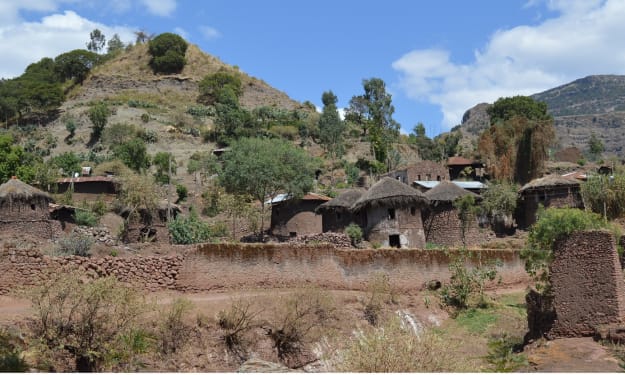
For my team, our ascent is typical enough. We trek the edge of a sheer escarpment cut by streams that plunge as some of Africa’s highest waterfalls, into the Precambrian bedrock that roots Ethiopia into its antediluvian past. Perched upon the edge of an imposing, ancient basalt mesa, our destination looms. Through an implausible geological narrative, our path winds higher, one massive terrace atop the other, hinting not only at this land’s extreme antiquity, but its insular nature as well. Ethiopia is what it is because of the uplifts and deeply cut ravines we trek. These upland islands form pockets of isolation, natural fortifications that have bastioned her people against outside influences for millennia.
From our pinnacled vantage point, voices, distant and muted, rise from the valleys below, petitioning a quiet, hallowed feel. Soft winds carry the hymns of nature’s spired sanctuary. Nearer at hand, wild jasmine infuses the breeze with her reckless passion.
Each turn in the trail affords a new, majestic view extending to the world’s edge. Vultures circle high overhead. Our late afternoon sun now gently rakes his golden rays through the clouds, inviting one to envision a stairway of ascending and descending angels. No wonder this place, and its people are so religious. Even the landscapes invite reverence.
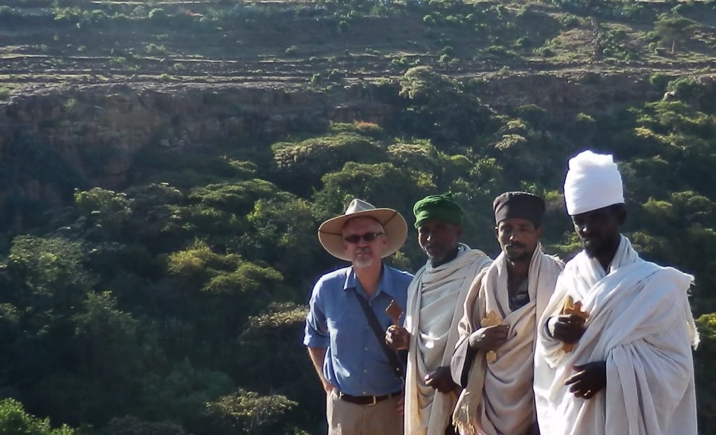
In camp, beside a smoldering fire, evening’s shadows creep across the valley-floor. An alpine glow bathes the summits that ring us in. Dusk deepens its dying-ember-gray into African-mountain-black. A half-dozen elders, white-robed and regal, mingle in hushed tones. Lanterns across the ravine, silent, shy and shallow, glint, where, during our trek, stone-walled enclosures, villages, and churches, nestled amid the fertile terraces, tell of Ethiopia’s ancient heritage. Today’s discoveries will shake the world and rewrite Africa’s history.
Above, constellations pirouette their quiet, removed, ageless strides across the heavens. Content, invigorated for tomorrow, we reflect upon the beauty and newly identified ruins we have been witness to, and know we are forever changed.
--The Land of the Queen of Sheba –
Ethiopia has long been famed as the land of the illustrious Queen of Sheba. Indeed, it is the crux of what defines so much of its religious affinity. Variably throughout history, her peoples have been called Aethiopies, Abyssinians, Habesha, and now Ethiopians. In antiquity, this mystical land of Sheba built its wealth around trade in frankincense and gold. But traditions related to the Queen of Sheba and King Solomon also focus upon the virtues of their devotion and respective wisdom. This combination of God and gold, woven from Ethiopic Jewish and Christian mystic narratives, became the fabric from which a new national identity was tailored over the last seven centuries.
During this same time, under King David, the tribes of Israel rose from a cluster of nomadic, pastoralists to a sedentary state, establishing its capital at Jerusalem. The prestige and renown of this kingdom grew. In one of King David's psalms (68:31) he states, “Ethiopia will stretch out her hands to God.” At the end of David's forty-year reign, Solomon, his son, ascended the throne.
It is not surprising, then, given how magic and myths have woven their threads through Ethiopia’s history, we find in legends that the queen of this distant, exotic land of Sheba heard of King Solomon through the aegis of a talking hoopoe bird. She is the imperial power of her day. Hers is the long-established realm of wisdom and wealth. It is she who comes to test young Solomon's secret knowledge, and perhaps magic, to discover what lay behind the meteoric rise of this new regent. In a sense, as the personification of Ethiopia stretching out her hands to take hold of Yahweh, King David's God, the Queen of Sheba fulfills his prophecy. In Arabic she is remembered as Bilqis, in Tigrinya, Makeda Negiste Sa'ba.
In the medieval period, post crusades, Ethiopia tied itself back to Jerusalem via the magical literature coming out of Jewish, Christian, and Islamic traditions related to Solomon and the Queen of Sheba. Ethiopians claim the couple produced a child named Menelik, from whom all legitimate Kings of Ethiopia are descended. As the story goes, Menelik returned to Jerusalem, fashioned a replica of the arc of the covenant, and absconded with the original, taking it to Ethiopia where it remains today.
This tradition and belief, as told though the Ge'ez text, Kebra Negast, or the Glory of the Kings, expanded through eight centuries of princes, kings, and emperors, up to the last emperor who was titled, His Imperial Majesty, Haile Selassie I – the Conquering Lion of Judah of the house of David, King of Kings, of the Solomonic dynasty.
– The Prester John -
Legends germinate and sprout into myths, tall-tales, and traditions. For early medieval Europe, things were not going well. Their crusades were sputtering. Plagues stalked their towns. New threats loomed from the east. In their search for assurances, they cast a wide net. Enter the story of a powerful, wealthy, African-Christian, Priest-King whose pedigree matched that of Jesus Christ.
By the end of the 14th century, these legends, with their incumbent hopes of finding an ally, made their way into Europe’s highest courts. Maps, mostly drawn from fantasy, claimed anything south of Egypt belonged to this majestic monarch. Drawing inspiration from the Bible and Herodotus, they claimed this region known as Ethiopia, was also Eden. To find this king, Europe launched its age of exploration. This required new maps, accurate maps.
In the first decades of the 1400's, a scholar-monk named Fra Mauro, from the monastery of San Michele di Murano in Venice, was commissioned to create a world map based upon the most recent research and travel accounts from explorers across the Mediterranean region. He compiled notes, collected maps, and over the next decade, poured over manuscripts and recorded interviews of travelers, ambassadors, and seafarers.
Scholars from Constantinople, sages from India or regions farther east, ambassadors and priest from Ethiopia, supplied snippets of data. Rarely, knowledge tumbled in tomes, more often, however, only as fragments lost to the west for centuries. Gradually, for the first time in Europe, remote, empty spaces on his map blossomed into mysterious, unknown cities or mountains tied to such legends. Thankfully, the region of Abassia Ethyopia was sketched by the very hands of intrepid sojourners from these furthest reaches of our globe.
--The Map in the Mind -
Maps represent our three-dimensional world within a two-dimensional, mental construct. Each paints a time-bound icon for visualizing a particular worldview. In essence, maps embody the world made in our image. Fra Mauro's mid-15th century masterpiece of medieval cartography now provides scholars a rare lens into a radically variant geographical mindscape during one of the most critical transitions in world history.
This scholar’s resulting circular map, two meters in diameter, appears to have served not simply as an aid in expediting navigation or exploration, rather, it looks to be designed specifically as a laying out the foundations for a new world order. By drafting geographical features, regional and city names, navigable trade routes, across his mappa mundi, Fra Mauro identifies possible alliances alongside real and potential threats. Anything Christian, even the thinnest web of connectivity, is emphasized.
Mountains feature prominently throughout. Passes or rivers clearly bisect habitable landscapes, demarcating regions and polities. Every city stands fortified, bounded by copious notes on regions, rulers, rivers, and where gold, spices, pearls, and fresh water can be found. Ships, identifiable with the dominate traders, ply their respective seas.
--The World Within a Gilded Frame –
To set the stage for this intriguing story, consider that Ethiopian emissaries in the mid-1400’s related geographical knowledge of their regions to a Venetian monk, who then transcribed their data on a two-meter diameter parchment. Fortunately, along with local chronicles and hagiographies, itineraries of contemporary Europeans visiting these regions, provide substantial evidence of thriving communities.
Most modern scholars, however, still consider the regions of Africa I was studying to be fabrications of a medieval mind. But my discoveries in surveys across Ethiopia convinced me, I was onto something big. We trekked landscapes described nearly six centuries prior. Again, the facts on the ground astounded.
Regarding these regions then, Fra Mauro states, “Because to some it will appear as a novelty that I should speak of these southern parts, which were almost unknown to the Ancients, I will reply that this entire drawing, from Sayto (Assiut, Egypt) upwards, I have had from those who were born there. These people were clerics who, with their own hands, drew for me these provinces and cites and rivers and mountains with their names; all these things I have not been able to put in due order for lack of space.”
Nearly six centuries on, having survived various European wars, those medieval icons of mountains and rivers, along with descriptions of rulers and names of long-lost cities, make their way, as a digital copy, to an African-born archaeologist working in Ethiopia, hoping to discover the buried capitals many believed never even existed.
My first task was to employ an Afrocentric, indigenous frame of reference for my ongoing research. Within many African cultures, proximity to neighbors is measured by relationship or a scale of time, not in distances. The word, Karibu, means “Welcome,” in Swahili, but it can also mean “close” or “near.” When trekking in East Africa, therefore, upon inquiring the distance to the next village, the answer depends on the closeness of the village relationally, not proximally. I have walked over 30 kms, passing through “far away” villages, to get to the “close one.”
On the Fra Mauro map, African distances are similarly inscribed. Cities along the highland ridge, known best by his informants, are situated neatly along the highland trade routes used even today. Specific characteristics of each city indicate familiarity, or karibu to these monks. Lost cities such as Barara and Sadai, are shown with multiple cultural elements and architectural features. Islamic regions along the coasts, for the most part unfamiliar to Christian monks, are depicted in uniform monotony.
--A Cartographic Rosetta Stone –
Like a cartographic Rosetta Stone, I started decoding the current physical landscapes back onto the flat iconography portrayed so elegantly in early renaissance style. Rivers and mountains clearly designated the major physical features enfolding respective medieval provinces and kingdoms. Centuries on, this geography still broadly defines Ethiopia’s current regions, distinguished by factors of language, cultures, and religious expressions. Cities within these regions were illustrated as turreted towns laying along trade routes.
My initial task in untangling the provinces of Abassia Ethyopia, writ large across most of central and east Africa, was to recognize these identifiable geographical features and polities transposed by reputable Afro-centric clerics, scholars, and representatives of these regions. Discernable rivers, mountains, kingdoms, or provinces and cities are clearly defined. Many retained the same, or similar names to known features. The main capital cities indicated this African Christendom’s sovereign as Prester John with oversight from the Metropolitan of the Coptic church of Alexandria.
Armed with these data, I initiated my investigation. Focused upon known or identified geographical features, I “translated” the Fra Mauro map, much as an epigrapher would an ancient manuscript. Subsequent medieval maps followed the main geographical features and remained constant. Slowly, like a developing embryo, I witnessed these features morph from medieval icons into recognizable place names of regions or trade routes. All named cities, however, were destroyed in the mid-16th century and never rebuilt.
How then could I physically locate and discover an ancient or medieval site listed on the Fra Mauro map, but long-forgotten and lost for centuries? Could I read the physical geography of current landscapes and interpret them back through the centuries to the actual landscapes as described by mid-fifteenth century Ethiopian monks? To crack the code of the Fra Mauro map, I had to try.
My first hurdle required I demythologize the majority of maps from the following centuries. The second hurdle involved geopolitical ramifications wrought by decades of war in the middle of the 16th century where regional conflicts had left near desolation to both sides. Subsequently, many of the main population centers depicted on the Fra Mauro map, had ceased to exist. By the end of the 17th century, the memory of the raging conflicts between the Islamic forces of Imam Ahmad, and the variably named Christian kingdom of Shoa, Xoa, or Sewa, had cooled to an uneasy, smoldering détente.
These wars, however, had prompted migrations of populations with the influx of new cultures and languages. A shifting of place-memory displaced most previously associated oral traditions. Alternate land use and new agricultural practices swallowed up previous occupational contexts. Where once thriving urban centers dominated, sparse villages dotted the landscapes. Former international trade networks all but disappeared. In the highlands, new population centers with new names replaced anything old. Undaunted, I pressed on.
--A Tale of Two Lost Cities-
I chose a site on Fra Mauro map called Sadai or Saba within the southern reaches of Abbasia. It is listed as Regno de Saba or the Kingdom of Sheba, like the queen, and of Prestor John. On the map, it lay on the west slope of a mountain called Ambanegst and northeast of the Awash River, and south of a mountain range that runs east-west. It also is north and far west of the place we still call Mt. Zokouala. The only large mountain fitting that description is called Menagesha-Wechecha. East lay the still unidentified capital city of Barara, indicated as the principal residence of Prester John.
Fra Mauro illustrates Sadai hugging the western slope of his Mt. Ambanegst. Using Google Earth, I searched for locations fitting our parameters. And there it was. Large, circular fortifications upon a knoll overlooking the entire western and much of the southern frontier. Clear evidence of architectural features accompanied by crop marks indicated possible occupation over an area extending several kilometers square. Sadai had been one of the first cities destroyed by the marauding forces of Imam Ahmad Gran. All subsequent maps, therefore, cease all mention of this ecclesiastical capital. Since I had no possibility of cross-referencing its location, I elected to physically visit the site to confirm what I saw on images.
A small team visited the southern-most identified features. Cultural materials like stone tools and pottery, and architecture were immediately evident across our transects over an area of several hundred meters. Thinking like medieval strategists, we moved from high-point to high-point, noting walls and remains of earthen bulwarks with moats and ditches. Everything indicated urban habitation.
Subsequent visits proved three substantial occupational areas with distinct fortification sites. Each contained dense period-specific pottery and architecture, with monumental walls of varying stages or phases of occupation. Immediately south upon an isolated hill, lies an ancient church complex with a series of pre-Christian funerary monuments which were deliberately toppled, and a series of well-built, rectangular, architectural elements. Medieval pottery scatters the field and the road leading to the church.
Local farmers and church deacons reiterated stories of the sites, referring to the area as Sada or Sabu. The forested slopes they simply call “the walls.” We were told Sadai is the local word for standing stones, like the ones identified in the ancient, pre-Christian cemetery. This was our Eureka moment; a previously un-identified site, fitting the descriptions on the ancient Fra Mauro map, containing substantial architecture and quantities of medieval pottery, all spread over an eight kilometer transect. This had to be the long-lost city of Sadai. But to confirm, I returned to my collections of historical and modern maps for hints to validate this as our candidate.
I traced feasible trade routes, constraining geological or topographical features, and traveling distances between identified sites and settlements against associated geographical landmarks. I evaluated soil types, rainfall patterns, hydrological data, and vegetation potentials in relation to relief maps. Remarkably, certain trends echoed repeatedly across the centuries. Specific physical features consistently restricted the parameters of trade into and out of the highlands. At strategic choke points, I found ruins of medieval fortifications. Upon protected, defensible ridges with sufficient access to water and agricultural soils, yet close enough to trade routes, remains of larger population densities were secreted away.
But it was a technological shift in the tools of war that generated the biggest shift in occupational patterns. The introduction of the musket and cannon in the early 16th century altered what constituted defensibility. Moats and wooden palisades proved inconsequential to gunpowder. This factor, more than any other, rendered most earlier medieval sites and fortifications obsolete. Adding this new variable to my equation enabled me to create an invaluable template of where pre-16th century site should be situated.
--How to Lose a City -
Further investigations in the field confirmed the uncanny accuracy and completeness of Fra Mauro’s informants. They also indicate a far more complex and rich societal narrative of Ethiopia than is commonly portrayed. So what happened? How does one lose an entire city? In a word, wars.
As a result of these religious wars, a huge influx of multicultural migrations led to new settlement patterns and agricultural practices which shifted the way land was utilized. What previously had constituted defensibility for a city, shifted. The political landscapes and settlement densities moved to higher ground. Small land holdings replaced large urban centers. As a result, across Ethiopia’s landscapes, centuries of agro-pastoralism have literally plowed the ruins of once-thriving metropolises into the ground.
Accounts of the destruction of the capital, Barara and other cities and sites, indicate that demolition was total. Even grindstones were smashed to ensure populations had nothing to return to. During these wars, most associated religious structures, on both sides, along with their treasures of relics and manuscripts, perished, usually via fire. This loss of contexts with which to even begin to identify lost cities was exacerbated by a paucity of scholarship related to these eras. But it’s hard to hide cultural materials, such as ceramics, stone tools, occupational soils, etc. Such indices, a true archaeologist recognizes immediately.
Convinced I had cracked the code of the Fra Mauro map, I set my sites on the Holy Grail of lost medieval African cities, the Solomonic capital of Barara. All place-memory of this medieval capital had long-ago vanished. Though mentioned throughout Europe's medieval period as the capital of Abyssinia, anything related to the physical location of Barara remained a mystery. Strikingly, local chronicles never mention that name. But if Sadai existed, Barara had to as well.
--Barara on the Horizon-
Discovery wasn't going to be easy, but utilizing the remote sensing methodology I devised, I narrowed my search east of Addis Ababa, along the southern ridges of the massive Germama and Kessem river drainage basins, and areas south of the town of Sendafa, along the still visible ancient trade routes to regions north. Even today, this highland ridge-route serves as a gateway from the plains and valleys in the south into the highlands.
I wish I could claim to have discovered Barara on our first outing, but it took nearly another year of denials, and even once, being run off at gun-point, before finding our ultimate prize. On one of our first excursions, we entered the market town called Areda Weyra. An abandoned crossroads most days, this Saturday, it bustled, employing every mode of transport or beast of burden: camel, donkey, mule, horse-drawn carriage, motorcycle, and of course, the heads or backs of the panoply of humankind. Like a drama playing out as it had from medieval times, commerce from three distinct regions joined, bartered, and returned with goods in tow.
Throughout Africa, each beast of burden is suited to particular loads, climates, and environments. Camels thrive in the dry, lowlands and riverbeds at elevations below 1500m/5000ft. They cannot even breed at higher elevations. Mules and horses are midland animals, mostly suited to the fertile plains and flatlands of the regions south and the well-watered grasslands below 2600m/8500ft. Donkeys fit all elevations, but are the exclusive animal for higher elevations, steep ravines, rugged highland trails, and seemingly impossible passes.
This market town, at 2400m/7800ft, served as a rare intersection for all three species, and by extension, representing well-defined regional cultures, languages, and religious identities. Even if the memory of Barara had long dissipated to dust, watching camels undulate home down a trail used for centuries, or a horse canter across open stretches, or observe overburdened donkeys clatter down a steep, rubble strewn path, there remained a sort of mysterious kinesthetic memory at play.
This is what Medieval Ethiopia had been; a nexus of cultures and commerce for centuries, and it provided the first clue to keep us coming back for more. Inquiring of many aged priests, we were excitedly told this was an old place, destroyed in the religious wars. The emperors once lived here, they said, but no one knew exactly where. One jovial saint swept his hand across the horizon. “This is a blessed land, very rich, very good.” He smiled, and with a wink stated, “It is our Holy Land.”
With hopes high, we moved further along the south and west ridges, discovering many significant sites, but only legends or hints with names like Juggal or walls. Yet none recalled even a semblance to the name, Barara. Resolute, I continued my search.
--Moving Mountains –
Repeatedly, I returned to the maps. It was then I discovered that previous searchers consistently had compounded a singular error. The blue, three-peaked mountain indicated on the Fra Mauro map north of Barara was not Entoto, the mountain associated with Addis Ababa. Tucked away in the series of valleys north of the Germama river lies a region, aptly named, Sost Amba, “The Three Peaks”. We had the wrong starting point. The final puzzle pieces began to fall into place. This three-peaked mountain fit the exact parameters and location I had been searching for. Profoundly, previous searches had taken everyone 20-30 kms too far west. I moved my search east. Behold, Barara.
As a field-trained archaeologist with 30 years of experience, I made sure I covered all my bases. After an intensive desk-based analysis and field-walking, I needed to visit the site to confirm my scientific research. It is difficult to describe the anticipation of being the first ones to knowingly tread the ruins of a legendary city lost for nearly six hundred years. There is equal measure giddiness mingled with a sobriety.
For centuries Barara had eluded explorers. Yet this site covers more than 2 square kms, with large quantities of period-specific cultural materials along with wheel-made and imported pottery sherds throughout. We found substantial occupational soils, large architectural features including foundations for towers, a water system, five cemeteries containing hundreds of tombs with inscribed headstones. This substantial site ticked all the criteria boxes for a city the size and importance of Barara.
Oral traditions and place names fit exactly what we have sought.” Bar” means gate. Mt. Yerer is locally called, Arra, thus, the gate to the region of 'Arra, or Bar-'Arra. The local name of the site translates to “The Assembly of Multitudes.” Such a name retains the importance this region held in earlier time. Other interpretations of the meaning for Barara refer to “light” or “redemption.” Future research may tie the traditional Ethiopic name to the site we now identified with Barara.
From a professional, archaeological standpoint, the site identified as Barara, is exactly what we would expect for a city with pre-medieval, medieval, and post-medieval occupational contexts. Today, the surrounding villages still contain mixed, Christian and Islamic communities. Additionally, it is exactly where Fra Mauro’s informants claimed it to be. The consistent misreading of a map, notwithstanding, Barara is clearly indicated as directly south of three peaks (Sost Amba), east of the bend in the Akaki river, northwest of the confluence of the Dukem and Mojo rivers, and west of the fertile Tich plain. No true professional, seeing the broad cultural contexts on the ground, tied with the multiple site identifications we have made, would state otherwise.
– Building a Strong Foundation –
This, and so many other newly identified sites, contain fantastic archaeological value and potential to provide a promising beginning. In my on-going exploration, no day is ever routine. Daily I am tantalized with just enough of Ethiopia’s secrets to keep me coming back for more. With every footfall, the ground seems to reverberate this noble history’s sheer will to be retold.
Regarding this region in Africa then, it appears the Fra Mauro map has proven itself far more than the fanciful rendering of a medieval mind. It simply requires professionals to interpret and decode this medieval, African geography.
Questions inevitably remain pertaining to the underrepresented, complex subjects of ancient and medieval studies within Ethiopia and the broader regions. Ethiopia must tell its larger, deeper significance of its own history and heritage and take its rightful place in the histories of civilizations. The mysterious, forgotten past that paints all of Ethiopia’s landscapes in myriad colors of the impossible, should inspire us. The brilliance of such varied, interred, newly-discovered empires whisper their faded splendor to all who still intently seek it.
I remain hopeful that with skilled scholars in the emerging culture/heritage, research, and tourism sectors, I can continue to help preserve and present Ethiopia’s rich cultures and deep heritage. I envision the next wave of exploration, discovery, and excavation under the skillful hands and careful eyes of Ethiopian experts and archaeologists.
Meanwhile, my colleagues and I wait. As does a young girl sitting in the shade of the spreading fig tree, watching her goats graze among the hundreds of tombs on the slopes of Barara. But who will tell her what it means that she is offspring of some of the most powerful and impressive empires sub-Saharan Africa has ever known. And herein remains the dream. This child, and so many others like her, waiting, may soon learn to apprehend her broader Ethiopian heritage in true ways. One day, she may be the one who vocalizes her emerging story of identity, as we carefully excavate and reveal these hidden, neglected jewels of past magnificence.
About the Creator
Sam Walker
Born & raised in East Africa, I spent fifteen years in the Middle East: Yemen, Israel/West Bank, Jordan, Sudan, and Egypt. I then worked for 7 years in Micronesia. I currently am conducting archaeological research in Ethiopia and Kenya.
Keep reading
More stories from Sam Walker and writers in Wander and other communities.
Origins
Ethiopia – Land of Our Origins – Ethiopia encompasses a profound, punctuated, three-thousand-year chronicle of identity. The intricate, rich tapestry of heritage it still weaves relates a story as compelling and significant as are its various and complex, ancient empires. As a specialist in history, archaeology, religions, and ecologies, I help unravel these stories, framing them within their broader historical and modern, regional contexts. Delve with me, into the mysteries, the myths, the monuments, the men and women who continue to define the ever-shifting kaleidoscope slowly being revealed as this amazing, ancient land called Ethiopia.
By Sam Walker3 years ago in Wander
Perfect Little Pirate
The rough, sodden rope bit into her fingers as she swung over the roiling water far below. Reaching out with the toe of her boot, she managed to catch hold of the rain-soaked railing of the ship- and promptly slipped. Throwing herself forward, she landed hard on the deck, slamming her elbows against the wood planks. The sharp yelp of pain quickly bubbled into a laugh, and she rolled onto her back, laughing up at the gray sky as a torrent of rain washed away the soot covering her skin.
By M. A. Mehan 4 days ago in Fiction

Comments
There are no comments for this story
Be the first to respond and start the conversation.