
1947 Partition of India & the River Indus: An Untold Tale
At midnight of August 15, 1947, the largest recorded forced migration in modern history began.
Millions of Hindus, Muslims, and Sikhs were forced to journey hundreds of miles and experience brutal violence as the Indian subcontinent was divided into two independent nation states following the dissolution of the British crown rule on the part of the United Kingdom. The partition involved the division of two provinces, Bengal and Punjab, based on district-wise non-Muslim or Muslim majorities. The self-governing countries of Hindu-majority India and Muslim-majority Pakistan came into existence. The partition also saw the division of the British Indian Army, the Royal Indian Navy, the Indian Civil Service, the railways, and the central treasury. As a person from this region, I am closely related to this event, and in this blog I will tell a different and lesser known story about the impacts of partition on the mighty Indus river system that connects the Indian Subcontinent.
image of the indus river snaking through Ladakh
River Indus snaking through Ladakh in Indian-administered Kashmir (Shutterstock)
The affluent waters of the Indus system of rivers begin primarily in Tibet and the Himalayan mountains in the states of Himachal Pradesh in India and the disputed territories of Jammu and Kashmir. They flow through the states of Haryana and Rajasthan in India, Punjab that is shared by both countries, and then Sindh in Pakistan before emptying into the Arabian Sea south of Karachi and Kori Creek in Gujarat. As the river moves downstream it carves out a valley. People have settled here for thousands of years and laid the foundation for the Indus Valley Civilization. The first farmers settled near the river because it kept the land fertile for growing crops. These farmers lived together in villages which grew over time into large ancient cities, like Harappa and Mohenjo-Daro in modern-day Pakistan. The Indus people needed river water to drink, wash, and to irrigate their fields. They may also have used water in religious ceremonies. The Indus people referred to the river as ‘The King River’.
1947
During partition, communities that had coexisted for a thousand years succumbed to an eruption of sectarian violence. More than a million people were killed and between 10 and 12 million people were displaced along religious lines, creating an overwhelming refugee crisis in the newly constituted dominions. The violent nature of the partition created an atmosphere of hostility and suspicion between India and Pakistan that plagues their relationship to the present.
While extensive scholarly work has been conducted to investigate the human rights atrocities committed by both sides, less has been done to document how nature, and in particular rivers, suffered at the hands of the partition. The impacts of this chaos on the mighty river Indus were not addressed until 13 years after the partition when both states finally realized that water was a matter of life and death for their new-born agriculture-based economies.
Muslim refugees clamber aboard an over-crowded train near New Delhi in an attempt to flee India
Muslim refugees clamber aboard an over-crowded train near New Delhi in an attempt to flee India (Open Magazine)
According to a World Bank report published in 2014, the average annual available water resource in Pakistan is 218.4 billion cubic meters. Developments over the last century have created a large network of canals and storage facilities where there was once only a narrow strip of irrigated land along the rivers. Since 2009, this infrastructure has provided water for more than 47 million acres (190,000 km2) of agricultural land in Pakistan alone, making it one of the largest irrigated areas of any one river system in the world.
1960 - Indus Water Treaty
The partition of British India created a conflict over the waters of the Indus basin. The newly formed states were at odds over how to share and manage what was essentially a cohesive and unitary network of irrigation. Furthermore, the geography of partition was such that the source rivers of the Indus basin are located in India. Pakistan felt that its economic possibilities would be threatened by the prospect of Indian control over the tributaries that feed water into the Pakistani portion of the basin. India had its own ambitions for the development of the basin in the form of dams and barrages, and Pakistan felt acutely threatened by a conflict over the main source of water for its cultivable land.
map of the Indus River and main tributaries (marked in green against an orange backdrop)
The course of the Indus River and its main tributaries.
During the first years of partition, the waters of the Indus were apportioned by the Inter-Dominion Accord of May 4, 1948. This accord required India to release sufficient waters to the Pakistani regions of the basin in return for annual payments from the government of Pakistan. The accord was meant to meet immediate water needs and was followed by negotiations for a more permanent solution. However, neither side was willing to compromise their water access and negotiations reached a stalemate. From the Indian point of view, there was nothing that Pakistan could do to force India to divert the river water into the irrigation canals of Pakistan. Pakistan wanted to take the matter to the International Court of Justice, but India refused, arguing that the conflict required a bilateral resolution.
Clauses of the IWT
The Indus Waters Treaty (IWT) was finally signed in Karachi, Pakistan on September 19, 1960 by the first Prime Minister of India, Pandit Jawaharlal Nehru, and then President of Pakistan, Ayub Khan. According to this agreement, control over the water flowing in three “eastern rivers” of India — the Beas, Ravi, and the Sutlej with the mean annual flow of 33 million acre-feet (MAF) — was granted to India, while control over the water flowing in three “western rivers” of India — the Indus, Chenab, and the Jhelum with the mean annual flow of 80 MAF — was granted to Pakistan. More controversial, however, were the provisions on how the waters were to be shared. Since Pakistan’s rivers receive more water flow from India, the treaty allowed India to use western rivers water for limited irrigation use and unlimited use for power generation, domestic, industrial and non-consumptive uses, such as navigation, floating of property, and fish culture, while laying down precise regulations for India to build projects. The preamble of the treaty declares that the objectives of the treaty are to recognize the “rights and obligations of each country in the settlement of optimum water use from the Indus System of Rivers in a spirit of goodwill, friendship and cooperation.” Despite this diplomatic premise, Pakistan continues to fear that India can create floods or droughts in its territory, especially at times of war between the two countries, given that substantial water inflows of the Indus basin rivers are derived from India.
Signing of the Indus Water Treaty, 1960 in Karachi, Pakistan
Signing of the Indus Water Treaty, 1960 in Karachi, Pakistan
Retreat ceremony at the India-Pakistan boarder with two flags crossed overhead
A daily retreat ceremony at the India-Pakistan joint border check post of Attari-Wagah
Since the ratification of the treaty in 1960, India and Pakistan have not engaged in any official water wars. Most disagreements and disputes have been settled via legal procedures provided for within the framework of the treaty despite three wars and many war-like situations for other reasons, including territorial disputes. The treaty is considered to be one of the most successful water sharing endeavors in the world today, even though analysts acknowledge the need to update certain technical specifications and expand the scope of the document to include climate change mitigation strategies.
Implications - Use of Water as a Weapon of War
This said, in the aftermath of the September 18, 2016 attack by four heavily armed terrorists near the town of Uri located in the then Indian administered states of Jammu and Kashmir, India threatened to revoke the Indus Waters Treaty, claiming that the violence was backed by the Pakistani government. The current Indian Prime Minister Narendra Modi declared, "blood and water cannot flow together." Thus far, a suspension of the treaty has not materialized. However, India decided to restart the Tulbul Project, which is a barrage with an expected storage capacity of 300,000-acre ft (370×106 m3) of water on the Jhelum River in the Kashmir Valley, that had previously been suspended in response to Pakistan’s objections. Similarly, in the aftermath of a February 14, 2019 attack on a convoy of vehicles carrying security personnel on the Jammu Srinagar National Highway by a vehicle-borne suicide bomber in the Pulwama district, Jammu and Kashmir, then Indian Minister of Roads and Water Resources, Nitin Gadkari, declared that all water presently flowing into Pakistan from the three eastern rivers would be diverted to Punjab, Haryana, and Rajasthan in India for various uses. Hasan Askari Rizvi, a political analyst in Lahore, Pakistan, has explained that any change to the water supply of Pakistan would have a "devastating impact" on the millions of Pakistanis who directly and indirectly depend on the river.
Water Offensive graphic with text on photograph of the Indus in the background
Indian government formulating ways to violate the Indus Water Treaty (Times of India)
Abuse of the Rights of Rivers and its Relations to Floods
Poor decisions made by both governments for political and economic gains have had devastating impacts for local riverine communities on both sides of the border for the past 72 years. It is possible to link the floods occurring almost every year in the subcontinent to the misuse of the Indus Water Treaty, or better yet, to the violation of rights of the river. Despite the fact that the causes of the floods have primarily been linked to unusually strong monsoon spells, there is a need to study the impacts of India’s construction of hydroelectric dams in the basin.
A girl floats her brother across flood waters whilst salvaging valuables from their flood ravaged home in the village of Bux Seelro near to Sukkur, Pakistan.
A girl floats her brother across flood waters whilst salvaging valuables from their flood ravaged home in the village of Bux Seelro near to Sukkur, Pakistan (Guardian)
Areas affected by the 2010 floods in Pakistan Source: United Nations World Food Programme, ESRI ⓒ 2010 MCT
Areas affected by the 2010 floods in Pakistan (Source: United Nations World Food Programme, ESRI ⓒ 2010 MCT)
2010 - Pakistan Floods
The floods in Pakistan began in late July 2010, and approximately one-fifth of Pakistan's total land area was affected. According to statistics produced by the Pakistani government, the floods directly impacted about 20 million people, mostly in the form of the destruction of property, livelihoods, and infrastructure, with a death toll of close to 2,000. The World Health Organization reported that ten million people were forced to drink unsafe water, and the Pakistani economy was deeply harmed by extensive damage to infrastructure and crops.
By building dams and barrages and manipulating the treaty for political interests, both governments have diverted the natural flow of the River Indus. This has destroyed the river’s ecology, displaced people whose livelihoods depend on the river, and impacted the biodiversity of the Indus Delta in the name of national interests and “sustainable” development. In reaction to this situation, several local communities and environmental non-profit organizations are arguing that there is need for the River Indus to be restored, so that the river flows from start to tail end following its natural course. They also defend the need to recover the biodiversity of the basin as well as the livelihoods of riverine communities. Earth Law Center, an international non-profit organization that aims to transform legal codes to recognize and protect nature’s inherent rights to exist and flourish, has partnered with Pakistan Fisherfolk Forum, a non-governmental organization that works to advance the social, economic, cultural and political rights of fishermen and fishing communities in Pakistan. The Indus River has suffered from severe declines in both water levels and quality and continues to face severe threats, such as unplanned irrigation and unsustainable dam construction. Thus, as long as the law treats the Indus River as mere property to be exploited for profit and political gains, it will continue to be diverted, dammed, and polluted by both States.
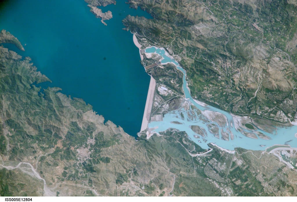
satellite image of Tarbela Dam
Tarbela Dam, an earth-filled dam along the Indus River in Pakistan’s Khyber Pakhtunkhwa province (NASA Satellite image)
To address this situation, Earth Law Center and Pakistan Fisherfolk Forum are working with other partners to achieve the recognition of the legal rights of the Indus River. They have written a draft called the “Indus River Rights Act” that is under review by political leaders in Pakistan.
The draft law recognizes the inherent rights of the River Indus, which include:
The right to flow
The right to perform essential functions within its ecosystem
The right to be free from pollution
The right to feed and be fed by sustainable aquifers
The right to preserve and restore native biodiversity
The right to be restored
Earth Law proposes placing guardianship of the river in the hands of local riverine communities in partnership with the Pakistan government. These guardians would be asked to represent the Indus River in legal proceedings, enter into contracts on its behalf, and take other actions necessary to protect the basin. If implemented, these rights could prevent the construction of further dams on the river. Recognizing the rights of the Indus could shift the public perception of the river from property that can be partitioned to a relation with a life-giving partner. This shift could allow for the recovery of regional biodiversity and new collaborations between riverine communities. While it is important to understand the political, human rights, and economic dimensions of the 1947 Partition, it is equally vital to understand the way colonial legacies and the violent creation of nation states have impacted river systems and watersheds.
About the Creator
Keep reading
More stories from aman mehta and writers in The Swamp and other communities.
Rivers of Death
Rivers bring water the element essential to all life on Earth but wherever rivers flow they also bring death surprise attacks Savage kills and brutal fights every day is a battle for survival on these rivers of [Applause] death I'm under the African Sun Staying Alive is hot thirsty work and among the ranks of animals jostling to get a drink lurk Killers waiting to strike but while Lions may be fearsome and the huge Nile crocodiles ruthless Predators one of the continent's deadliest River Killers is mostly vegetarian renowned wallowers spending up to 16 hours a day lounging in the water hippos could be mistaken for relaxed creatures and yet the river horse as their name translates from ancient Greek can be a very angry pony indeed with tusks up to a foot and a half long hippos are literally armed to the teeth and a charging bull Hipp can impact with the weight force of a pickup truck what's more hippos May brutally defend their territory an Impala has been chased into a muddy Watering Hole by a lion it's stuck but for fortunately for the stricken analou the lion is reluctant to follow it into the Meer unfortunately it finds itself in the domain of a hippo ill disposed to uninvited guests the hippo's not stealing the watching Lion's meal she's most likely just aggressively defending her calf and the Impala pays the ultimate price for crossing a doting mother hippos are thought to kill more people each year than the rest of Africa's most dangerous animals combined and during mating season their ruthless aggression is directed at other hippos two bulls square up the pod's dominant male and a Challenger at stake the Riverbanks Prime mating territory and a Herm of females the dominant male puts on an aggressive display posturing to show he will not yield but the interloper Demands a fight finally the dominant male is Victorious the Conqueror celebrates with a dung shower marking the border of the territory he has successfully defended while the vanquished suffers more than just the agony of defeat his back is carved open and by Sunset the crocodiles are watching closely they'd be unlikely to take on a bull in rude Health but now they Circle an expectation the hippo breathes his last the price of insurrection is life his Hulk will not go to waste the crocodiles move in swiftly to Feast on the corpse for these voracious Predators it's a considerable meal but one dead hippo is a mere snack compared with the annual Feast provided by a particular African river each year the serengetti vast grass Plains filled to the Horizon with grazing animals taking part in one of Nature's greatest spectacles around 1 and2 million wilder beast join 700,000 other herbivores on the Great Migration around 1 in six of these migrants will die before completing the 500 M circuit many are outrun and taken down down by Africa's formidable array of Savannah carnivores their Journey coming to a Grizzly end but one of the deadliest single obstacles the vast herds must Traverse is the mara River after 3 months on the move the wilderbeast are exhausted and emaciated all that separates them from the Fresh pastures of the msai mara is the width of the river and a whole bunch of huge ravit Nile crocodiles despite the chilling threat posed by these powerful Predators some of the herd are either oblivious to the danger or so thirsty they dare to take a drink anyway for an unlucky few it will be their last and these witless victims merely wet the Croc's appetite the true Feast begins when the first of the herd Braves the river in the crush and Chaos of the crossing the 16t Crocs grabs scores of victims when 1,600 lb of musc futile the marus Crocs survive on meager rations for most of the year so take full advantage of the great migrations time of Plenty they Gorge themselves eating up to half their body weight in one sitting and with so many different species crossing the river the banquet is as varied as it is Bountiful but not all Africa's Crocs have such an easy meal ticket on the banks of this Kenyon River a Croc has got too close to a pack of feeding Lions a move it's about to regret it's a fierce attack but the Crocs skin is covered in bony armor plating eventually the Lion's Uninvited Guest Retreats having taught the Crocs and dinner manners the big cats return to the carcass the Amazon is a giant of a river and and conceal some monstrous Predators which kill with a crush and in a bloody frenzy draining a lowland Basin of close to 3 million square miles around 1/5 of the water that runs off the earth's surface is carried by the Amazon this giant of a river is renowned for its oversized residence both prey and Predator around 4 ft long and and weighing as much as an adult human capibara are the world's largest rodent they're
By cacloaidongvat2 days ago in The Swamp
Iran and Israel: Dangerous Game.
Israel and Iran have been locked in a deadly duel for decades. Ever since Ayatollah Khomeini came to power in 1979, both nations have been at loggerheads. Israel did help Iran briefly, in the First Gulf War of 1980 - 1981. Iraq was a common enemy of Israel and Iran. Israel helped the Iranians with weapons. Sadly, that moment in history is a blip in an otherwise confrontational relationship.
By Nicholas Bishop6 days ago in The Swamp


Comments
There are no comments for this story
Be the first to respond and start the conversation.