
Sixty Seconds Over Palm Beach: How a Learjet 60 Went From Cruise to a Fireball
A routine request to climb around weather, a burst of supercooled droplets, and the T-tail question at the center of the NTSB probe.
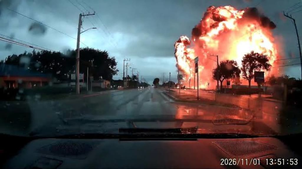
Shortly after noon, near a road in Cresthaven, Palm Beach County, Florida, a dashcam captured a fireball. The aircraft struck a residential area almost vertically, leaving a crater and debris along the shoulder. Police closed the road in both directions, and about 600 residents were asked to evacuate. U.S. Transportation Secretary Sean Duffy confirmed on social media that all nine people on board died. The FAA reported that the aircraft was a Learjet 60, registration N722BD, which had departed Austin-Bergstrom International Airport in Texas and was bound for the Bahamas.
Reports gave two figures for the distance between the crash site and Mar-a-Lago: “seven or eight kilometers” and “more than ten kilometers.” That distance has no technical bearing on the cause. The 60 seconds preserved in radio recordings and flight data is the part investigators have to take apart.
1. The Last 60 Seconds
Flightradar24’s altitude curve is steep. While cruising at about 35,000 feet, the female pilot heard on the Miami air traffic control recording reported moderate turbulence and altitude fluctuations of several hundred feet. She reported precipitation and “light clear icing,” and called it manageable. Outside temperature was minus 47 degrees Celsius. She asked whether a smoother altitude was ahead, then reported precipitation and requested a climb from 35,000 to 37,000 feet. ATC cleared the climb.
After the clearance, the transmissions changed rhythm. The pilot declared Mayday and reported descending at 10,000 feet per minute. The next transmission described an overspeed condition and a 20,000 feet per minute descent. The next gave 22,000 feet per minute and a bank angle of about 60 degrees. The recording contains the sentence “We’re going to crash into the ground.” From 35,000 feet to the ground took about 60 seconds. The last altitude data received was 8,750 feet at 17:49:22. After 17:48:55Z, the recording contains only static.
Around the same time, Cresthaven police posted a road-closure notice on social media. The community center became an evacuation point, and volunteers moved bottled water, folding tables, and power strips. The screams on the recording and the moving of tables happened in the same noon hour.
2. Where Does Ice Come From at Minus 47 Degrees?
At minus 47 degrees Celsius, most cloud moisture has already turned into ice crystals. Ice crystals that strike a wing usually bounce off or attach loosely. They do not readily form the clear ice that changes an airfoil’s shape. The pilot called the icing manageable. That creates the first technical paradox: if the ambient temperature was that low, where did the ice that threatened pitch control come from?
Meteorologist Matthew Cappucci’s preliminary analysis points in one direction. Near the crash site, a rapidly developing thunderstorm cell rose from below 33,000 feet to about 48,300 feet in roughly 20 minutes. Explosive convection means strong updrafts, and those updrafts can carry supercooled water droplets, water that remains liquid well below freezing, to unusually high altitudes. Supercooled droplets freeze instantly on contact with an aircraft surface and form clear ice. Clear ice is hard, adheres firmly, and can change the shape of a lifting surface. If an anti-ice or de-ice system meets an environment where the supply of supercooled droplets exceeds the rate at which the system can evaporate or remove them, ice can still build in unprotected areas or where the system has little margin.
Investigators now have to determine whether the thunderstorm cell that N722BD passed through created a localized, high-concentration supercooled-droplet environment near 35,000 feet, and whether that environment was intense enough to exceed the aircraft’s protection boundary in a short period.
3. The Vulnerability of the T-Tail
The Learjet 60 has a T-tail, with the horizontal stabilizer mounted at the top of the vertical tail. In normal flight, this layout is efficient. In icing conditions, it has a structural vulnerability. Ice on the leading edge of the horizontal stabilizer changes the airfoil and reduces the stabilizer’s ability to produce the downward force that balances the wing’s nose-up pitching moment. Once ice on the stabilizer leading edge reaches a certain point, the nose can pitch down under the aerodynamic imbalance.
The pilot’s instinct is to pull back on the yoke. When the horizontal stabilizer has already lost aerodynamic effectiveness, the nose-up moment from pulling back is limited. The descending nose keeps increasing speed. Once speed exceeds the maximum operating speed, aerodynamic forces become extreme, and control inputs struggle to produce enough moment to counter the descent. The chain becomes: stabilizer icing, nose-down pitch, increasing speed, further loss of control effectiveness, an unrecoverable dive. Flightradar24 recorded a bank angle of about 60 degrees just before the steep descent, consistent with aerodynamic loss of control.
In 1999, the FAA issued a proposed airworthiness directive covering several Learjet models, including the Learjet 60. Its stated purpose was specific: prevent undetected ice accumulation on the leading edge of the horizontal stabilizer, which could lead to loss of pitch control and reduced aircraft controllability. A regulatory document from more than twenty years ago cannot directly explain this accident. It does show that horizontal-stabilizer icing has been a known threat to pitch control in Learjet models within the regulatory system.
4. Two Possibilities Investigators Must Separate
The NTSB is leading the investigation, with the FAA assisting. A preliminary report is expected within weeks. A final report typically takes 12 to 24 months. Investigators will examine the flight data recorder if it can be recovered, the debris distribution, weather radar data, maintenance history, and crew actions.
One unresolved question is the integrity of the horizontal tail. Still frames from dashcam video appear to show the descending aircraft missing its horizontal stabilizer. Debris analysis must confirm that observation. If confirmed, the investigation will split into two questions: did aerodynamic forces tear off the horizontal stabilizer during the dive, or had it already failed because of icing before the dive began? The two possibilities sit in different places in the causal chain. The first points toward structural loads and the flight envelope. The second points toward the performance boundary of the ice-protection system.
Another unresolved question is the state of the anti-ice and de-ice systems at the time of the accident. The “manageable icing” in the recording is a crew judgment, not system data. The NTSB will need to place system switch states, bleed-air configuration, surface temperatures, and the meteorological environment on the same timeline.
5. On the Ground
Beside the crater, the road remained closed in both directions. Rescue workers gathered the wreckage, and debris remained along the shoulder. On the folding tables at the community center stood bottles of water, and volunteers registered evacuated residents. FAA and NTSB vehicles were parked outside the cordon.
After 17:48:55Z, the recording contains only static.
About the Creator
Jin
Writer of reamstories
https://reamstories.com/jin
Enjoyed the story? Support the Creator.
Subscribe for free to receive all their stories in your feed. You could also become a paid subscriber, letting them know you appreciate their work.
Comments
There are no comments for this story
Be the first to respond and start the conversation.