

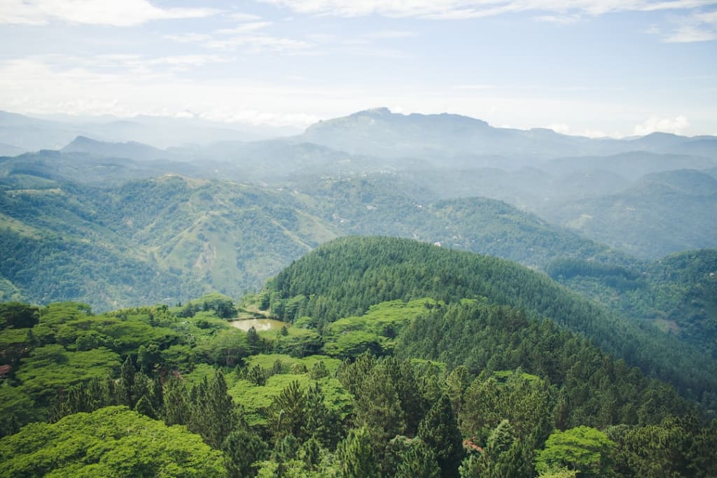
Dolosbage, which translates literally from Sinhalese as "half dozen", is a mountain range approximately 100km east of Colombo, and 40km southeast of Kandy. Located in the middle of Sri Lanka's tea-growing region, the six mountains of Dolosbage are cloaked in thick jungle and laced with wilderness trails that provide the explorer with a variety of experiences; from a weekend of camping in the open to a day of mountain climbing, or a few hours of hiking. This is one of the scenic roads full of greenish mountains & gets misty.
Kabaragala mountain is the highest peak of the Dolosbage mountain range with an altitude of 1500 meters. It has an almost flat terrain similar to that of the Horton Plains. Also, a very large fallout similar to the Word End. It is located in the Sabaragamuwa Province of Sri Lanka. It is bordered by the villages of Dedugala and Palampitiya to Kandy. Uda Palampitiya, the highest point in the area, is 4000 feet above sea level. It is a heavy and cool place with frequent frosts. A road leading from Bulathkohupitiya to Nawalapitiya through Dedugala, Palampitiya has fallen. However, a vehicle such as a car can only go as far as Uda Palampitiya on this road. This is one of the most scenic roads. From Bulathkohupitiya to Dedugala. m. Although the 20-mile road is narrow, it has been paved with carpet. All these roads are full of elbow bends. In the meantime, you can see many waterfalls. It is a special advantage for tourists to be able to see all the waterfalls in this vicinity in one day from Colombo.
Places to visit
- Uda Palampitiya
Do you know that the Kegalle district also has a healing mountain environment known as 'Little Nuwara Eliya'? When you pass Dedugala and go to Uda Palampitiya, you get to experience that environment. Km from Bulathkohupitiya on Dedugala road. This village is located at a distance of 20 km. A village is extremely close to Dolosbage trunks on the border of the Kandy district. It is quite close to Nuwara Eliya district. It is about seven kilometers from Dedugala to Uda Palampitiya. It is a winding road with a steep incline as the topography rises to 2700 feet above sea level within seven kilometers.
There are many reasons why environmentalists call Uda Palampitiya Little Nuwara Eliya. One of them is that even on sunny days, the area is suddenly covered with rain, darkness and heavy snow. The environment is cold due to the high altitude and the occasional cool winds blowing from the Dolosbage mountains. Surrounded by tea gardens and gardens. This site has also been designated as Ritigaha Oya Environmental Protection Area. Dolosbage town in the Kandy district is only five kilometers from Uda Palampitiya. But this road, which has fallen between mountain ranges and steep slopes, is not yet fully constructed. It is said that this is the first instance of a new highway being built through Kegalle, Bulathkohupitiya to Nuwara Eliya.
It is said that after the construction of this road, the distance between Colombo and Nuwara Eliya will be reduced by about forty kilometers. At the entrance to this Dolosbage road from Uda Palampitiya, there is a wonderful natural rock. It is a place where you can see the charm around it. From this place, you can see the Shripada mountain range almost at arm's length. Villagers say that the lights of Colombo city can also be seen from outside these hills during dry seasons. There is also a protected grassland area called Palampitiya Pathana. There are no tourism facilities in Uda Palampitiya as there is still no large arrival of local or foreign tourists.

- Nalagana Ella
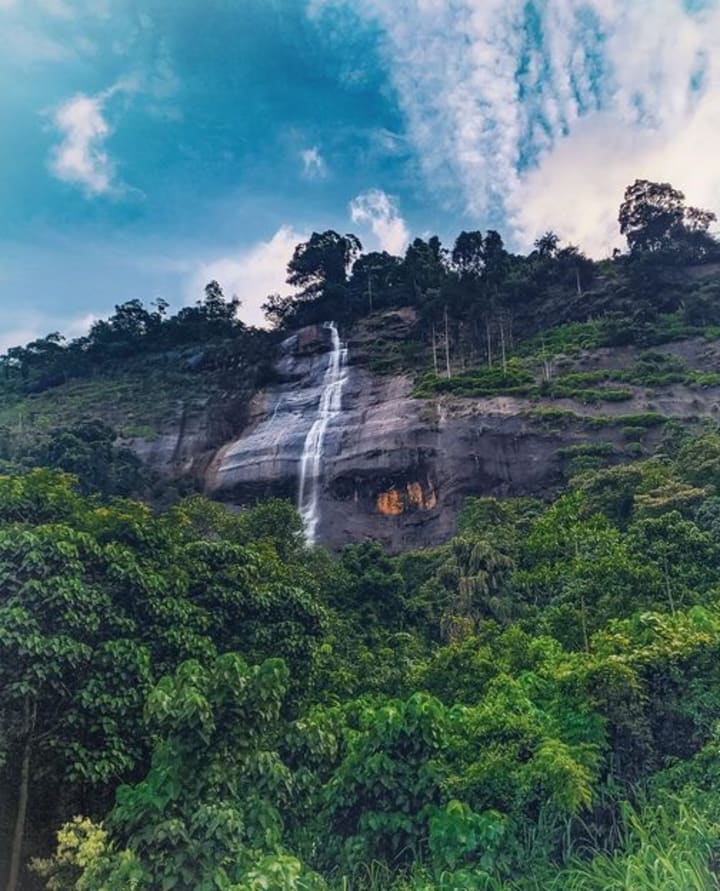
Nalagana Ella Falls in Dedugala Springing from the Ritigaha Oya, a tributary of the Kelani River, The Falls comprise a number of chutes, each measuring about 40m in height. It is situated at Dedugala, 9km away from Bulathkohupitiya. It descends like a veil over a vast granite rock bed into a deep lake located on a steep hill approximately 8 kilometers from Bulathkohupitiya, however it is usually hidden by bushes and plants. The river flows parallel to the Bulathkohupitiya-Dedugala road. The water of Nalagana Falls cascades down like a woman's saripota, hence the name. Folklore's tale is as follows. However, Nalagana Falls' water level has altered recently. That is a result of the nearby power plant. So that there is no significant stream of water flowing down, the power plant takes water from the top of the cascade. You might witness a stunning vista on wet days.
Very risky since the water level of the fall may rise quickly and without warning. Riverine vegetation that is diverse can be seen. But the route to the falls is not entirely apparent. A tiny hydro plant is where you must turn off the main road at a curve. then proceed down the trail to the river by ascending. The falls will be visible.

- Punahela Suramba Ella Falls
On the Ruwanwella Bulathkohupitiya path, which travels 6.2 kilometers past the Warawala town, lies the 15-meter-high Punahela Suramba Ella fall. Although the fall can be viewed from the road, getting a closer look requires crossing a suspension bridge.
- Welanda Ella Falls
Numerous waterfalls may be seen along the Bulathkohupitiya-Dedugala Road. The Welanda Ella Waterfall is the first waterfall along this path. On the Dedugala road, 3.7 kilometers from Bulathkohupitiya, there is a concrete-paved road that crosses a creek to the right. To get to this fall, you must go about 500 meters on this road and walk about 500 meters through rubber plantations and parts of the bush. To reach the waterfall, it is preferable to go with someone who is familiar with the paths as the route is not indicated. The waterfall descends in two stages, with the bottom step being the highest at roughly 20 meters.
Even during the rainy season, there is seldom much water at the waterfall because it is located on a little creek. During the dry season, it nearly completely dries out and is hardly worth the trip. Even though there isn't much water, when it rains, it cascades over a broad rock edge and forms a thin but wide vail. It cascades over a stony plain rather than into a pool at the bottom, allowing anybody to safely stroll up to the waterfall.
- Dummala Ella Falls
Both the stream and the location where the Dummala Ella Fall is located were formerly known as Thattibathgoda Ela and Katuhena, respectively. After losing a battle, King Walagamba is said to have taken sanctuary in the neighboring woodlands. On Poya days, a golden Thatti is supposed to be seen floating on this stream. The monarch is said to have cleaned his eating vessel (Thatti) in this stream.
- Rikilla Ella (Rikili Ella) Falls
The stream that originates on the northern side of the Hunusahaldeniya mountain range is the source of the 30 m Rikilla Ella (Rikili Ella) water fall (600m). It travels to the Kelani River via Ritigaha. The Dedugala highway is 5 km away, and Kitulgala is the closest town.
- Ruckmal Ella Falls
The greatest place to observe this 10-meter-high Ruckmal Ella fall (Rukmal Ella) is from the road. Travel 13 kilometers down the route to the east from Bulathkohupitiya to get there. From Kitugala Rest House, it is 45 kilometers.

- Devagiri Ella Fall
Despite its height, this Devagiri Ella Fall does not receive many visitors because of where it is located. The waterfall is located not far from Dedugala on the Dolosbage-Bulathkohupitiya Road. This waterfall may also be referred to as Diyangiri Ella by the locals. The Dedugala Ehala Palanpitiya (mountain), located in the Kegalle District, is the fall's source. This waterfall, like most others, is most beautiful when it is raining. During the dry season, the water flows substantially decrease.
- Kelvin Falls
Located close to Windsor Kelle (Windsor Forest), this 3 m-high Kelvin Falls runs down a 1050 m slope to the Wee River. The closest town is Nawalapitiya; to locate the fall, travel down the Dolosbage Mountain route and then turn onto the road that leads to Windsor Kelle.
- Windsor Forest Falls
Only when it rains will Windsor Forest Falls, a pair of 10 m high waterfalls, flow. It is located 49 kilometers from the Pusselawa rest house and 44 km from the Kitulgala rest house through Nawalapitiya Ginigathena. The town of Nawalapitiya is the closest.

- Diyathiri Ella Falls
A branch of the Maha Oya (river), which originates at a height of 1574 meters on the north-western side of Gentry Box Mountain, is the source of the Diyathiri Ella waterfall. The water travels 125 kilometers to the sea at Waikkal, north of Negombo in the Kammala region, after the fall's 30 meter plunge. The closest town is Nawalapitiya in the Nuwara Eliya District. From here, go 20 kilometers in the direction of Dolosbage; Meenagala Estate and a projecting rock face are where you'll find the fall.
The way to reach
Those coming from Colombo or Ratnapura should turn right at the Warawala roundabout at Avissawella via Karawanella and Ruwanwella towards Galigamuwa and reach Bulathkohupitiya via Dedugala road, On your way to the Twelfth, you can see these beautiful places.
Those coming from Kegalle can reach Bulathkohupitiya via Hettimulla, Morontota, Moradana and Udugoda and use other alternative routes. It would be even better if you could use the map to make your journey easier.
If you go by bus you can come to Bulathkohupitiya from Avissawella and take the Dedugala bus to see some of those places.

Google Map:
About the Creator
Zeloan
I'm a Traveller, Blogger, and Content Creator. Visit Sri Lanka, and you can see the most beautiful places in the world and the remarkable hospitality here
The Rise of Tre Jones: A Basketball Phenom Making His Mark
*San Antonio Spurs Point Guard Putting Up Strong Numbers** Tre Jones, the starting point guard for the San Antonio Spurs, has been on a tear lately. Currently averaging **10.0 points, 3.7 rebounds, and a stellar 6.2 assists per game**, Jones has been a bright spot for a young Spurs team. **Recent Highlights:** * **Triple-Double:** Jones recorded his first career triple-double on April 2nd against the Denver Nuggets, chipping in 10 points, 12 rebounds, and 11 assists. * **Scoring Surge:** Jones has averaged 11.8 points, 6.7 assists, and 4.8 rebounds over the last 11 games, shooting over 50% from the field. * **Playmaking Prowess:** Jones has dished out at least 10 assists in seven games this season, showcasing his ability to create scoring opportunities for his teammates.
By Yunus Bashit3 days ago in Journal
Midnight
60 seconds… 59 seconds… Time was slipping through his fingers, though he clawed at the falling grains of sand, he could not stop the hourglass from flowing. Around him, the silence was deafening. He had taken over every screen in the command centre, putting the terrible seconds before the terrified eyes of his friends and comrades.
By Alexander McEvoy2 days ago in Fiction


Comments
There are no comments for this story
Be the first to respond and start the conversation.