
Europe Series - Geostructures of Ancient Greece
Geostructures of Ancient Greece

For a long time, the Mycenaean civilization only existed in the "Homer Epic" with a strong mythology. For the origin, development, and dating of the Mycenaean people, more need to rely on archaeological discoveries to provide evidence. In contrast, when Athens-Sparta became the protagonist of the Greek peninsula, the development of ancient Greek civilization became much clearer. Especially after the "Hippo War" in the 5th century BC, the history of Greece also has a formal written record (the beginning of the Western Classical period). However, this also means that it is necessary for us to sort out the plate structure of the Greek peninsula from the perspective of geographical structure. Otherwise, everyone will feel at a loss when faced with the geographical labels that keep popping up behind.
If we do not count the overseas territories that ancient Greece once colonized, the Greece we see today is roughly the same as that of Greece more than 2,000 years ago. However, like the situation in East Asia, ancient Greece also had the problem of the core area and the peripheral area on the Greek peninsula. At least when the Spartans and the Athenians started the "classical period" supported by history, the tribes living in northern Greece today were regarded as barbarians by the Greeks who claimed to be civilized people in the central and southern parts of the country. This includes the Macedonians who later came to Greece and brought Greek civilization into the imperial era.
In terms of plates, the Macedonian region where Alexander and his ancestors operated was not the only marginal area on the Greek peninsula. On its west side, there is also a coastal mountain, Epirus, across the sea from the Apennine Peninsula (Italy), which is also located on such an edge. In fact, the Macedonia-Epirus region was also the only way for the Proto-Indo-Europeans to go south to the central and southern parts of the peninsula. That is to say, the four ancient Greek tribes that appeared before have all stayed in these two lands. The Dorians, for example, came south from Epirus and entered the Peloponnese through the Isthmus of Corinth.
I believe that most people have heard of "Macedonia". After all, the empire established by Alexander is impressive in terms of size and process. But when it comes to Epirus, there are probably not many people who know it. But it doesn't matter, we can start with the most basic geographical structure, and let everyone draw a map of the geographical structure of the Greek Peninsula and even the entire Balkan Peninsula in their minds.
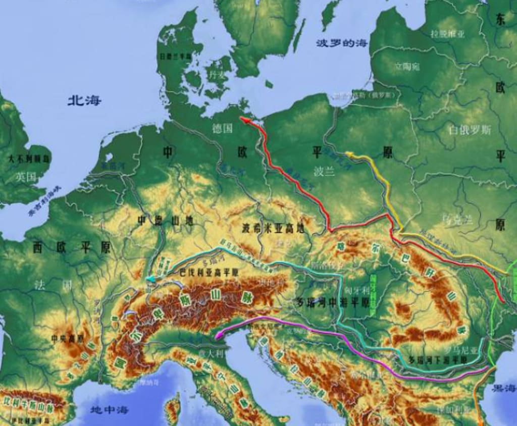
The so-called "Greek peninsula" is more of a geopolitical concept. Because from a geographical point of view, the Greek peninsula is only the southern tip of the Balkan Peninsula, and there is no obvious geographical dividing line between it and the Balkan Peninsula itself (unlike the Peloponnese). However, since the Greeks finally only chose to develop civilization in the southern part of the Balkans, rather than trying to expand northward to the entire Balkans, there must be a geographical structure. To understand this, we need to zoom in and see how this mountainous peninsula is cut into powder kegs by mountains.
This mountain range covering the Balkans is a mountain range called "Dinara". The western end of the mountain range, at the northeast corner of the Adriatic Sea (the Apennine – the sea between the Balkans), is connected to the largest mountain range in Europe: the Alps. It is because of this relationship that the Dinara Mountains are also known as the "Dinarque Alps". After filling the northwestern corner of the Balkan Peninsula and extending to the southeast to the middle of the peninsula, the Dinara Mountains did not extend linearly like a standard mountain range, but extended towards the Mediterranean Sea, the Aegean Sea and the Black Sea. Three branches: Stara Mountains, Rodopol Mountains, Pindus Mountains.
Combined with the attached "Geographical Structure Map of Ancient Greece", we can clearly see the existence of these three branches. Since the three branches spread out in a fan shape, a large lowland space is also formed between the three branches. At least we can clearly see from the topographic map of the Balkan Peninsula, which is densely mountainous, that the coastal zone on the eastern edge of the peninsula has relatively more room for development, and the boundaries of the geotectonic plates are relatively clear. As for the northwest area covered by the main vein of the Dinara Mountains, it can be regarded as the most complex region in the whole of Europe. The label of the so-called "Balkan powder keg" is also due to the constantly pruning and chaotic geopolitical structure of this region. Although after World War II, this region was integrated into the "Yugoslav League" based on racial attributes, but the final fate of this coalition sitting on a powder keg has been seen by everyone.
Although the terrain of the Dinara Mountains is very troublesome, the primitive Indo-European tribes who migrated from the north coast of the Black Sea to the southwest of the Balkan Peninsula do not need to be entangled in this complex mountain. They could have passed along the Black Sea-Aegean coastline, past the end of the mountains, and penetrated to the southern tip of the peninsula. Even in this process, we still have to encounter some obstacles in the mountains, and the difficulty has been greatly reduced.
Of course, this does not mean that we can use the travel time between the two to calculate the time it took for the original Indo-European tribes to migrate from the northern Black Sea to the Peloponnese. Because this process is actually a complex step-by-step penetration process. That is to say, the Proto-Indo-European tribes would first move to a geographical unit closer to the southern Russian steppe. However, after a period of time, due to population growth and competition, part of the population would move south until they finally reached the southern tip of the peninsula. .
The primitive Indo-Europeans who migrated south along the west coast of the Black Sea, after leaving the southern Russian steppe in the north of the Black Sea, will also step out of the Eurasian nomads, the most adapted "steppe" zone. They were greeted by a large plain with a more humid climate: the Lower Danube Plain (also called the Wallachia Plain). The most important river in Europe, the Danube, flows into the Black Sea from here. Due to the proximity to the mountains, there is more precipitation. This area was covered by temperate broadleaf forests before large-scale agricultural development. Usually, as long as the temperature is right (not too cold), the forested plains of Eurasia will eventually be developed into agricultural land. It is on this basis that the later Roman Empire was able to expand to the lower Danube plain in the Black Sea region. It is precisely because of this that the country that unifies this land today is called "Romania".
Obviously, the primitive Indo-Europeans in the nomadic steppe no longer regard nomadic herding as their only way of life after adapting to the forest area. However, for the ancient Greek-speaking tribes, they were not destined to stay in the lower Danube plain (in fact, it should be the result of a failed competition). Next to meet them will be the lowlands between the Stara Mountains and the Rhodope Mountains. The country occupying the northern part of this lowland today is "Bulgaria", and the original source of the Bulgarians is also a nomadic people (Bugals) from the Eurasian steppe. However, in the classical period, this region has a label that everyone is also familiar with - Thrace.
Most people know Thrace because of the Thracian, Spartacus, who was positioned as the leader of the slave rebellion in the history books. As for this land, not many people know about it. Geographically, Thrace is bordered by the Black Sea to the east and the Aegean Sea to the south. Of particular importance, the Turkish Strait between Asia Minor and the Balkans is also in the southeastern corner of Thrace. In other words, whether the Greeks or the rulers of the Asia Minor peninsula, if they want to expand their territories along the land, Thrace is the only way to go.
Based on this geographical relationship and the need to manage trade in the Aegean Sea, the Greeks did land on the coast of Thrace and established some trade strongholds. However, as far as the entire Thrace is concerned, during the period of ancient Greek civilization, the political and economic structure also showed the form of scattered agricultural villages. Compared with the Greeks who were keen on trade, the Thracians preferred to act as mercenaries for neighboring countries to earn extra income when they were not too busy. Given the location of Thrace, it is understandable that it became a barbarian land in the eyes of the Greeks when the fire of European civilization was ignited in the southern Aegean region.
In fact, the Thracians in the classical period did not originally live in the northeastern corner of the Balkan Peninsula. At first, they infiltrated southward to the lowlands between the Rhodope Mountains and the Pindus Mountains after the Greeks. zone. This plate with most of the coastline in the northern Aegean Sea is "Macedonia". Compared with the location of Thrace, Macedonia is closer to the Greek region that has entered the stage of city-state civilization. This also made it ultimately part of Greece. As for Thrace, the Greeks were only interested in its coastline. Without the intervention of the Turks, Greece today may still be able to have the coastline of the Thrace region in the Aegean Sea (now the Thrace region is divided by the three countries of Bulgaria, Turkey and Greece, and Greece has the least share).
About the Creator
Keep reading
More stories from guanjianwenti001 and writers in FYI and other communities.
European Series - The Development of Mycenaean Civilization and the Trojan War
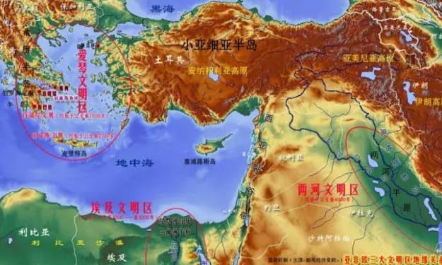
A friend asked before, since the two rivers civilization influenced the Egyptian civilization, is there an early civilization in the “West Asia Rift Belt” where Lebanon and Israel are today, as the connecting corridor between the two? The answer is of course yes. In the Geographical Relationship Map of the Three Major Civilization Areas in Asia, Africa and Europe, the three major civilization areas of the Lianghe, Nile, and Aegean Sea circled by us point to the center of civilization in the region. Affected by them, the tribes living in the surrounding areas will also speed up the progress of civilization. When Crete and even the Greek peninsula began to accept the fire of civilization, the West Asia Rift Belt, the Asia Minor Peninsula, the Armenian Plateau, and the Iranian Plateau, which were connected to the land and the center of the two rivers and the Nile civilization, had no reason to be in a barbaric era. . The Phoenicians, Hittites, and Assyrians were influenced by this and entered the age of nations.
By guanjianwenti0012 years ago in FYI
The Bloody Blood in Your Veins
Our Origins Today, I read something I didn't know—one more thing to add to all the other things I didn't know. By the time I grow up, I’ll have a collection. But it was intriguing, and it inspired me to write this post. I hope you enjoy it.
By Rene Volpi 12 days ago in FYI


Comments
There are no comments for this story
Be the first to respond and start the conversation.