
The evidence that points to a 'hollow' Earth
The inner secrets of our planet: PART FIVE

The core of the hollow Earth theory is that our planet is a shell with walls about 1,500 kilometres thick and openings at the polar regions with edges that curve smoothly from the outside of the shell to the inside.
Entering this inner world is like a fly crawling over the lip of a coffee mug from the outside to the inside, with travellers by air or sea fooled into believing they are crossing the pole by their compasses, when actually they are simply encountering the “magnetic rim” that leads to the inner Earth.
While there is no real proof of this being the case, the conventional understanding of the Earth’s make-up is also based largely on assumption rather than fact, with no method existing to directly sample the deep interior of the planet.
The deepest borehole into the Earth’s crust was made at the Kola Peninsula in Russia and reached a depth of only 12km, which is barely a scratch on the surface if you consider the average distance to the Earth's core is believed to be 6,500km... the sample of the Earth’s interior obtained from the hole on the Kola Peninsula representing less than 0.2% of this.
So how have scientists formulated the “solid” Earth theory if they have only tangible evidence of less than one per cent of its interior? To do this they have turned to seismology, using seismic vibrations to attempt to build a picture of the Earth's interior, which at best only offers a reliable interpretation of the composition of the crust.
However this method suggests the Earth consists of layered spherical sections... an inner core, outer core, stiffer mantle and then a crust closest to the surface.
This outer solid crust is believed to be about 7km thick beneath the oceans and 35km beneath the continents; while a mainly solid mantle (composed of iron-magnesium silicates) extends to a depth of about 2,900km. An outer core of liquid iron is then believed to extend to a depth of 5,200km, with an inner core of solid iron that has a radius of about 1,200km.
What happens when an earthquake occurs is that seismic waves spread out from its focus in all directions and include surface waves, body waves and free oscillations (vibrations of the entire planet).
Instead of travelling in straight lines, body waves are reflected and bent depending on the density, pressure, temperature and elasticity of the different layers of rock they pass through. So, on the basis of the time taken by different types of waves from specific earthquakes to reach different parts of the Earth’s surface, seismologists are able to determine the paths they have taken, the changes in velocity they have undergone at different depths, and the density and composition of the Earth at different levels.
But these ray paths are incredibly complex with waves often undergoing multiple reflections and refractions, their paths further affected by diversions at all levels of the Earth. This means that it is impossible for scientists to begin to interpret these seismic records without making certain assumptions about the Earth’s interior.
The main assumptions are that the interior consists almost entirely of solid or liquid physical matter, and that temperature, pressure and density increase with depth. These assumptions are generally believed to be self-evident.
But at several depths there appear to be discontinuities where the velocity of seismic waves changes abruptly. Such discontinuities are often transition zones rather than sharp boundaries, and vary in depth from place to place. The dominant boundary is that between the mantle and the core.
The standard view is that the continental crust consists chiefly of granitic capped by sedimentary rocks, while the ocean crust is composed largely of basalt and other igneous rock.
At the crust-mantle boundary, known as the Moho, seismic wave velocities change abruptly but there is no consensus on exactly why and since no drill hole has gone down that far it is impossible to determine anything with real certainty.
At the main discontinuities in the mantle, rocks are believed to undergo pressure transformations, with a 670km discontinuity marking the boundary between the upper and lower mantle. Seismic waves increase suddenly in speed at this depth and earthquakes essentially cease. This mantle is thought to be composed of peridotite.
The outer core is said to consist mainly of liquid iron, and the inner core of solid iron. The reasoning behind this is that there are two main types of body waves: primary and secondary. Primary waves are compressional or longitudinal waves that can travel through solids, liquids and gases, while secondary waves are transverse or shear waves that only travel through solids.
Seismic records suggest the way primary waves are refracted in the core indicates a solid centre, while evidence of secondary waves not travelling through the core is interpreted as meaning it also acts like a liquid.
But these waves can be reflected off any rock discontinuities within the Earth and the complexity of the possible theoretical ray paths means seismologists often draw contradictory conclusions from the same seismic data.
And the more scientists learn about the crust and the upper mantle, the more the models presented in geological theories about plate tectonics begin to seem simplistic. The outermost layers of the Earth now appear to have a highly complex structure divided by faults that represent a mosaic of separate blocks of different shapes and sizes, generally a few hundred kilometres across, and of varying internal structure and strength.
This fact, in conjunction with the existence of deep continental roots and the absence of a global surface layer, means the notion of huge rigid plates moving thousands of kilometres across the Earth is not really tenable.
The plate-tectonic hypothesis that the oceans have formed by sea-floor expansion is also becoming increasingly implausible, with far older continental rocks also having been discovered in the oceans as well as evidence of large, submerged continental landmasses.
But on this basis we have a model of the inside of our planet, which is not much better than pure conjecture. In truth, we know very little about the Earth’s interior.
A number of recent studies on seismic patterns are increasingly pointing to the existence of vast underground reservoirs beneath the crust with bodies under eastern Asia, in the northern Atlantic along the north-eastern coast of the United States and a volcano in the Andes, with suggestions that the Earth’s core may hold a vast proportion of the planet’s water inventory.
Michael Wysession, a seismologist at Washington University in St Louis, and his former graduate student Jesse Lawrence claim to have evidence of a huge reservoir that is at least the volume of the Arctic Ocean that sits beneath eastern Asia.
The team analysed more than 600,000 seismograms collected from instruments scattered around the planet and noticed a region beneath Asia where seismic waves appeared to dampen and slow down.
Wysession refers to the underground feature as the "Beijing anomaly" because the seismic waves were found to be weakest beneath the Chinese capital.
Another team led by Jon Blundy at the University of Bristol, UK, claims to have found a massive underground reservoir beneath a volcano in the Andes, also claiming the Earth could be dotted with similar wet pockets below other major volcanoes.
The Altiplano-Puna magma body is believed to be around half a million cubic kilometres in volume, so the researchers estimate it must contain a similar amount of water to some of the largest freshwater lakes on Earth.
Other sites with similar unexplained anomalies have been discovered beneath other volcanoes, such as those in the Taupo Volcanic Zone in New Zealand and Mount St Helen’s in Washington State.
Since the 1970s scientists have also suspected there is a gigantic freshwater aquifer hiding under the Atlantic Ocean, just off the north-eastern coast of the United States.
Although the aquifer’s exact size is still undetermined it could take take up an area stretching from Massachusetts to southern New Jersey, or nearly 350km along the coastlines of New York, Connecticut and Rhode Island.
The first hints of this reservoir go back to the 1970s, when companies drilling off the coast for oil sometimes hit freshwater, although they couldn’t be certain whether these bodies were isolated pockets or whether they covered a larger expanse.
Co-researcher Kerry Key, now a geophysicist at the Lamont-Doherty Earth Observatory at Columbia University in New York, began helping oil companies pinpoint hotspots by using electromagnetic imaging about 20 years ago.
More recently, in an effort to find freshwater deposits, Key decided to see if tweaking this technology could detect aquifers, which are underground pools of freshwater. So, in 2015 he and co-researcher Rob Evans, a senior scientist of geology and geophysics at the Woods Hole Oceanographic Institution in Massachusetts, took measurements off the coast of southern New Jersey and Martha's Vineyard in Massachusetts.
The researchers dropped instruments to the sea floor to measure the electromagnetic fields below. What they discovered was a vast reservoir of freshwater along the northern Atlantic coast.
Such discoveries add to growing evidence that significant amounts of water exist in the Earth’s interior, some of which could even be the source of the world’s oceans.
But what their discoveries mean is that scientists’ views of our inner Earth are constantly changing, with advances in technology regularly altering interpretations of what actually lies beneath our feet.
So, other than this seismic data, what other evidence is there that our planet and all planetary bodies, could be hollow?
Early scientists such as Edmond Halley, John Cleves Symmes Jr, Jeremiah Reynolds and Leonard Euler all believed the hollow Earth theory answered many of the questions rising from the magnetic anomalies occurring on our planet.
But before modern advancements in technology they could only guess at the Earth’s structure, but now the Earth has been photographed from space and analysed with hi-tech equipment, allowing researchers and scientists to get to know our planet in a far more complex way.
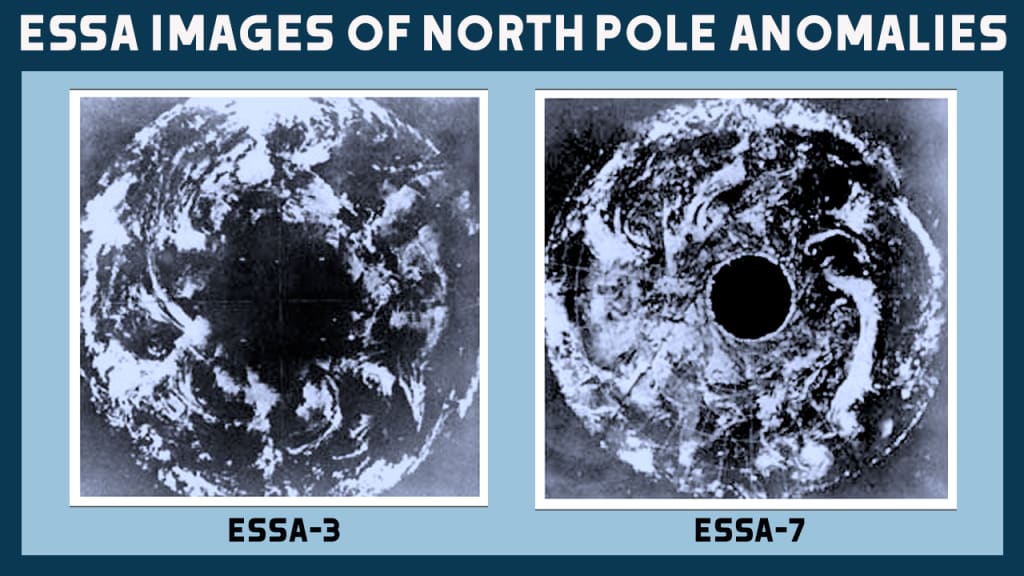
Seismology is yet to offer definitive answers but in the late 1960s pictures taken by satellites orbiting the Earth clearly showed the presence of a huge anomaly located at the North Pole, offering the first tangible evidence to support the hollow Earth theory.
In the early 1970s the Environmental Science Services Administration (ESSA) satellite project gave media access to images of the North Pole taken by the ESSA-7 satellite on 23 November 1968. One of the photographs showed the North Pole covered by the usual cloud, but another showed the same area without clouds, revealing a huge hole where the pole was supposed to be located.
Launched in 1966 ESSA-3, a satellite designed to capture detailed meteorological imagery for NASA, had also produced a composite image of the northern hemisphere that appeared to show an anomaly at the North Pole… the ESSA-7 satellite seemed to confirm this earlier result with practically a duplicate image taken from farther afield.
The two photographs are perhaps the best evidence of this North Pole anomaly but it’s strange that in the years that have followed, with the vast proliferation of satellites that have since been launched, nothing further has been officially released on the phenomenon.
The conundrum about the composition of our planet seems to be closely linked to other mysteries about our world, such the existence of extraterrestrials and the global phenomenon of UFO sightings and abductions… could it be that the lack of further satellite images of these anomalies at the poles is part of a huge cover-up by the organisations that govern our planet about the secrets of our inner Earth? I don’t know about you, but I’m beginning to think so!
About the Creator
Steve Harrison
From Covid to the Ukraine and Gaza... nothing is as it seems in the world. Don't just accept the mainstream brainwashing, open your eyes to the bigger picture at the heart of these globalist agendas.
JOIN THE DOTS: http://wildaboutit.com
Reader insights
Good effort
You have potential. Keep practicing and don’t give up!
Top insights
Compelling and original writing
Creative use of language & vocab
Easy to read and follow
Well-structured & engaging content
Excellent storytelling
Original narrative & well developed characters
Keep reading
More stories from Steve Harrison and writers in Futurism and other communities.
Whispering Woods Challenge Winners
Congratulations to Morgan Christy Rickards for their winning Whispering Woods story, Guardian at the Gate. Morgan has been a Vocal creator since February 2021, and this is their first time placing in Challenge — well done, starting with a win! Guardian at the Gate draws evocatively from Welsh tales of the Cantre'r Gwaelod, a lost sunken kingdom between the forest and the sea. Heledd’s dangerous adventure pulls her towards the water but her spirit is anchored in the woods: Morgan’s writing is atmospheric and exciting.
By Vocal Curation Team6 days ago in Resources


Comments (2)
Yes, the Earth is hollow, as are all other planets including our sun, inhabited by beings that have been her longer than humanity. Flat Earth is a psyop to divide and keep people from finding out the truth!
This is a subject that I've been interested in for a long time. It's well written but all credibility went out the window when reading the description of the author. It gives impression that he is a brainwashed MAGA boomer that worships Cheeto von Tweeto and has no concept of reality. The type of person that only listens to one view and one side and closed minded. The type of person that ignores all facts, scientific proof and professional research if it comes from a different political party. It's another sad example of how Trump has divided and destroyed America. The willingness to accept any absurd statement without a single shred of proof to verify has become a huge money maker for right wing media and infected the Republican party like a nasty cancer.