

uring the summer of 1883, a caldera in the Sunda Strait, located between the islands of Java and Sumatra, became increasingly turbulent, releasing huge plumes of ash and steam into the sky. Then, on 26 August, an underwater volcano ejected approximately 25 km3 (six cubic miles) of debris, hurtling pumice ash and boiling lava flows across nearby settlements. The eruption killed tens of thousands of people. Krakatoa remains one of the most deadly underwater eruptions in history.
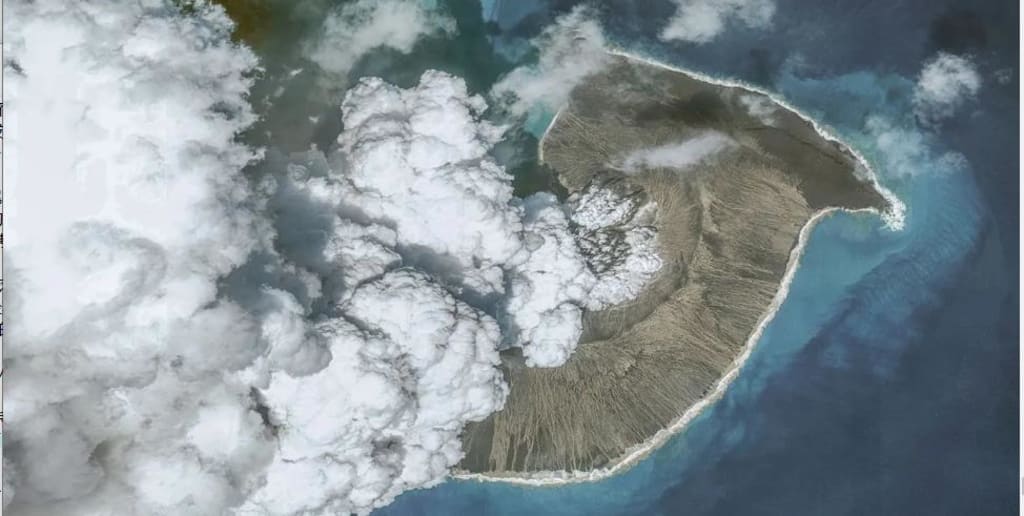
Nearly a century and a half later, on 15 January 2022, another underwater giant awoke from its slumber, this time off the shores of Tonga. The Hunga Tonga-Hunga Ha’apai eruption and resulting tsunami were different, however. Volcanologists were able to document the underwater mountain’s violent release in real time, and what they found confounded their expectations.
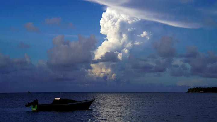
The South Pacific nation was all but cut off from the rest of the world after an undersea communications cable was severed by the explosion, but satellites captured hundreds of lightning discharges issuing forth from the volcano’s ash clouds. Remote sensors recorded powerful shock waves reverberating across the globe for days. A column of ash rose to never before seen heights, lingering in the outer reaches of the planet’s atmosphere.
The Hunga Tonga eruption remains a humanitarian disaster for the nearly 100,000 people who live in Tonga – and an unfolding tale of mystery and caution for the world. It prompted scientists to rethink their ideas on the hazards posed by the many submarine volcanoes lurking beneath the oceans. Now, the hunt is on to find these underwater seamounts in order to protect land and ocean alike.
You might also like:
The dive to find the world’s deepest shipwreck
The fish being turned into powder
The clash of nations under the ice
With increasingly sophisticated methods of detection, volcanologists hope to improve early warning systems, determine environmental impact, mitigate hazards posed by eruptions, and aid in ecosystem recovery. Who are the people trying to find where the next underwater volcano is hiding? And where do they look next?
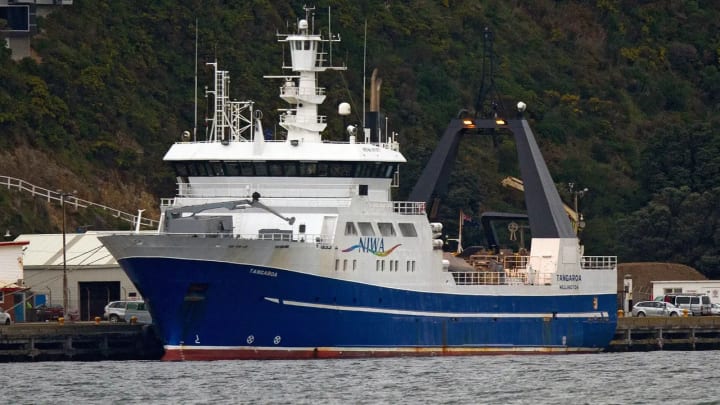
Volcanos in the deep sea are much more difficult to locate than those at ground level; indeed, we know more about the surface of the Moon than we do about the ocean floor. But Hunga Tonga’s eruption has galvanised the scientific community and underscored the need for further exploration of this uncharted realm. In April 2022, New Zealand’s National Institute of Water and Atmospheric Research (Niwa) launched an ocean voyage to the site Tonga’s dramatic eruption. Their vessel, the RV Tangaroa, surveyed thousands of square kilometers of the seafloor and collected video images and physical samples, which are now being studied back on land.
Given that the region is so seismically active, Niwa is in a unique position to investigate Hunga Tonga’s dramatic impact. “Before our voyage, we had only anecdotal information from the small boats that had gone out from Tonga’s mainland,” says Mike Williams, chief scientist of oceans at Niwa. Underwater volcanos often fall under their own weight. When seawater mixes with magma, this can lead to an explosive collapse, which in turn may generate a tsunami (and create noxious vapours on land). “Imagine a ringed cake tin, and one side has exploded outside of the tin,” explains Williams.
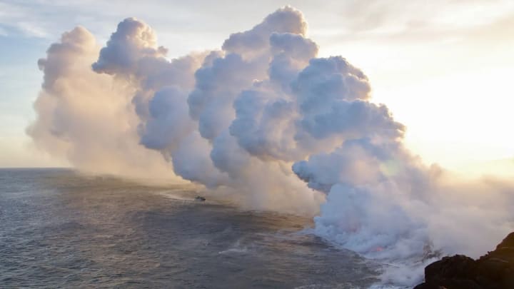
Researchers aboard the Tangaroa had a few immediate goals: map the site, retrieve volcanic deposits to help understand the chemistry and geology of the eruption, and examine the caldera’s impact on the surrounding seabed. “We arrived at the volcano at dawn, and saw the sun rise over two jagged peaks oozing fire and doom and violence,” says Kevin Mackay, veteran volcanologist and leader of Niwa’s voyage.
Once the vessel reached the outer caldera of Hunga Tonga, a remotely operated Deep Towed Instrument System (DTIS) traveled to the seamount’s flanks. There, the unmanned vessel glided down toward the seafloor like a torpedo with wings, allowing the team to record video footage and take samples. “It was a bit scary,” says Mackay. “The constant risk of a minor eruption under our steel boat meant we could, at any moment, sink in the blink of an eye.”
Few submarine eruptions have been documented because they are usually hidden beneath miles of ocean water
The team’s trial deployment of this new instrumentation allowed them to sniff out other volcanic plumes and to document changes to Hunga Tonga’s structure, which turned out to be rather dramatic.
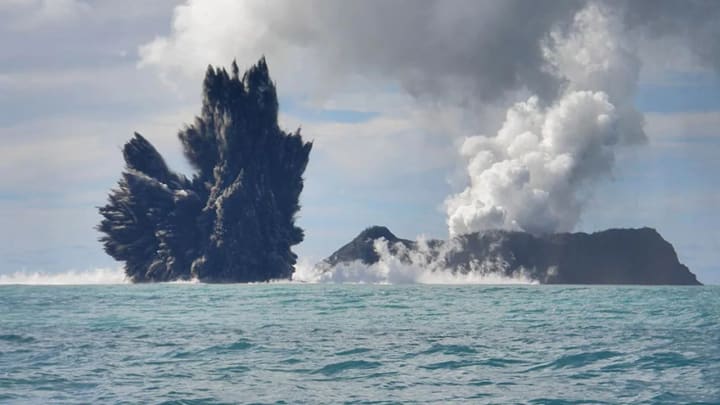
“Before the eruption, the caldera was about 120m (396ft) high. Now it’s a kilometer deep,” says Mackay. “Additionally, we found pyroclastic flows – turbulent, dense, violent rivulets that have flowed along the seafloor – at least 60km (37 miles) away, radiating from all angles.”
Niwa’s voyage was part of the Tonga Eruption Seabed Mapping Project, an endeavour funded by the Nippon Foundation, a non-profit based in Japan which has helped underwater research since 1962. The programme is also supported by the General Bathymetric Chart of the Oceans (Gebco), an organisation aiming to map the world’s ocean floor by 2030. While Niwa doesn’t actively monitor submarine volcanos, the organisation has an active research programme geared toward investigating seamounts, many of which are extinct volcanoes.
Few submarine eruptions have been documented because they are usually hidden beneath miles of ocean water. Those that scientists have observed, however, may give us clues to future disasters. In 2018, for example, an underwater eruption off France’s Mayotte Island gave rise to a colossal new seamount, revealing a high level of seismicity in the region. Mayotte is now continuously monitored, its activity regularly updated by a group of scientists on Revosima, a coordinated platform which watches over volcanic hazards such as magma flow, water temperature and acidity, as well as seismicity.
Efforts like Revosima are particularly critical for ongoing eruptions, but they are extraordinarily expensive. Ship cruise time and operations can cost up to €50,000 day (£43,500). Securing a cable near a volcanic site (which allows for local data collection) can cost millions. Infrastructure takes years to fund and establish.
But the research is critical – not just so that we can ascertain the dangers posed to us by active volcanoes, but also so that we can develop a better understanding of their environmental impact.
People are interested in volcanoes because they are a risk – Javier Escartin
The way that these natural phenomena occur can tell us about how ecosystems recover, since volcanic eruptions tend to follow similar patterns of destruction as human disturbances such as mining, ocean trawling, fishing and other extractive operations. Much of a submarine volcano’s impact may be from the stirring up of the seabed or the blanketing by sediment, for example.
“People are interested in volcanoes because they are a risk,” says Javier Escartin, bathymetric researcher at the Laboratoire de Géologie at the Ecole Normale Supérieure in Paris. “In general, deep volcanoes do not pose much danger; more dangerous are those near the sea surface or that emerge above it.” Approximately 1,500 potentially active volcanoes dot the globe (about 500 of which have erupted in recorded time), but those do not account for the continuous belt of volcanoes on the ocean floor – of which there are untold hundreds. Many of these are likely located along the Pacific Rim, in the so-called Ring of Fire which circles the Pacific Ocean. Most dangerous are volcanic islands where humans reside.
“Imagine an explosion the scale of Tonga in the Mediterranean or Hawaii,” says Escartin. “The death and destruction, the damage to the economy and transportation systems… but of course we can’t study the volcanoes if we don’t know where they are.”
How do volcanologists search for these as yet undiscovered submarine volcanoes, especially when bathymetric data is relatively sparse? Hydroacoustic monitoring is one answer. When a volcano erupts underwater, it produces acoustic energy: when lava as hot as 1,200C (2,192F) interacts with near-freezing seawater, it vaporises, causing an explosion of sound – from sharp cracks and thunderous booms to slow rumbles. Seismic energy is converted to underwater acoustic energy at the seafloor-water boundary, a kind of Goldilocks zone for those listening for underwater vibrations.
At depths of approximately 1,000m (3,300ft), pressure, temperature and salinity combine to slow the movement of sound through water, facilitating its transmission. This zone is known as the Sound Fixing and Ranging (Sofar) Channel (whales use this same acoustic channel to communicate with one another underwater). Hydrophones, or underwater microphones, can detect the acoustic signal from sound waves produced by a conversion of seismic energy along the Sofar channel. This acoustic data gives clues to the emplacement of lava flows, a potential warning of impending or ongoing eruptions.
This shotgun blast into the sky was unique – Kevin Mackay
Researchers understand the collapse of volcanic islands as part of their geological history, and some expect the flanks to give away and collapse into the ocean, resulting in landslides, earthquakes and major tsunamis. “Though we have not had one such major event in recorded history, consequences could be catastrophic,” says Escartin. In the meantime, geologists and volcanologists continue their underwater detective work with the “crime scenes” available to them.
Consider Axial Seamount, an active volcano off the Pacific Northwest coast of the United States, and the most active underwater volcano known. With documented eruptions in 1998, 2011, and 2015, it is also the most heavily surveyed underwater volcano in the world. Bottom pressure recorders show that Axial is slowly reflating, while remote operated vehicles have discovered new lava flows, suggesting another eruption could happen in the not-too-distant future.
The United States maintains a Volcano Disaster Assistance Program, which includes geologists, volcanologists and other experts in all aspects of volcano hazard assessment, monitoring and volcano-emergency response. Many governments have similar teams in place. Would-be amateur volcano hunters can consult the USG’s handy guide to volcanoes, including a FAQ about eruptions portrayed in movies (turns out scientists can’t actually drive across bubbling lava in real life). But the guidelines for underwater volcano-generated tsunamis are still being written.
“Hunga Tonga erupted out of type,” says Mackay, “and that’s what’s confused us: this volcano didn’t behave the way textbooks say it should.” The eruption in Tonga was more explosive than a super volcano, but instead of blowing apart, the volcano remained intact, prompting volcanologists to reassess their theories about what mechanism might have caused such violence. More puzzling still was the fact that Hunga Tonga’s energy dispersed in a sheer vertical pattern rather than outward across the seafloor. “This shotgun blast into the sky was unique,” says Mackay.
Hunga Tonga’s massive explosion not only generated ocean waves, it also produced sound waves and atmospheric waves, oscillations which radiated outward. These waves reached more than 100km (60 miles) into the atmosphere and traveled outwards at a speed approximately twice as fast as a jet liner. Even more unusual, “the waves didn’t follow the traditional pattern of decay”, says Williams. “They seemed to hold more energy and create a wave that was well recorded, even as far as the Ross Ice Shelf in Antarctica.”
Researchers are still trying to piece together the series of events that created, by any metric imaginable, one of the most devastating eruptions of the century. Hunga Tonga’s explosion was estimated to have unleashed the energy equivalent of 10 million tons of TNT, a paroxysm of ash and angry seawater that practically smothered the island.
The eruption not only disrupted local infrastructure, polluting water supplies and cutting off roadways; it had ripple effects across the globe. Earth is dotted with countless other submarine volcanos, any one of which could unleash its fury without notice. By studying Hunga Tonga, we can learn more about what protective measures to take when it comes to these other underwater time bombs, ticking away.
About the Creator
Baru Ku
"Your time is limited, so don't waste it living someone else's life."
| Huge Issue To Our Earth | Changing Climate: Understanding Global Warming and the Path Forward
Introduction Imagine a world with scorching summers, rising sea levels, and extreme weather events becoming commonplace. This, unfortunately, is not a scene from science fiction but the very real consequence of global warming, a phenomenon that is rapidly altering our planet's climate.
By jn smith_@#2 days ago in Earth
Shadows of Destiny
In the heart of a cobblestoned village, nestled between lush forests and rolling hills, there stood a mysterious mansion. Its grandeur was eclipsed only by the enigma that shrouded its history. The locals whispered tales of a cursed family, doomed to wander the halls of the mansion for eternity. But amidst the rumors and superstitions, there lived a young girl named Elara, whose curiosity knew no bounds.
By John Jemba5 days ago in Earth


Comments
There are no comments for this story
Be the first to respond and start the conversation.