

Since the floods in Pakistan, there have been satellites keeping a close eye on the spreading disaster, such as San Francisco-based Planet's 130 Earth observation satellites.
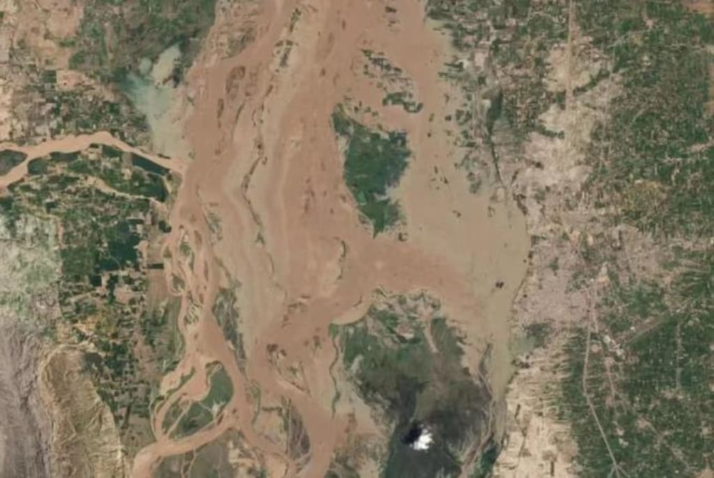
According to satellite images, the floods carried mud into the city, destroying buildings and surrounding vegetation, replacing it with a murky yellow color devoid of life.
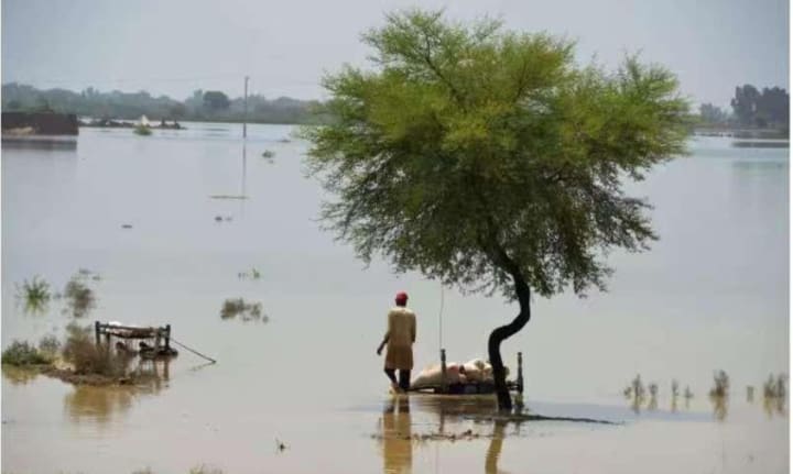
According to Pakistan's National Disaster Management Authority, these floods have killed more than 1,100 people, damaged more than 1 million homes, and affected more than 33 million people since June.
As of Aug. 26, 2022, homes in all regions of Pakistan were damaged by the floods.
However, just before the floods, the area was experiencing unprecedented heat, and at one point the drought and lack of rain made it difficult for countless people to survive. Even then, temperatures had reached 50 degrees Celsius in some parts of Pakistan and continued for several days, such as in the city of Jacobean in Sindhi province.
In addition, even sheep have reportedly died of heatstroke and dehydration in the Holistic desert of Punjab, Pakistan's most populous province and known as the country's breadbasket. If you look at the flooding in Pakistan today, it is true to the old saying, "A great drought is followed by a great flood."
The most direct cause of this flooding is the sudden increase in precipitation! Pakistan is used to monsoons and heavy rains, but surprisingly, these rains, which are supposed to be spread out over three or two months and come intermittently, have fallen in a concentrated manner this year.
The amount of rainfall was almost three times the national average for the past 30 years, reaching the highest level in 30 years. And a Transport-20 transport plane carrying Chinese humanitarian supplies for flood relief in Pakistan has arrived in the southern Pakistani city of Karachi.
But woe betides the extraordinary rainfall, the melting of the Himalayan glaciers has also added to the floods in Pakistan. At present, Pakistan has the largest number of glaciers in the world, except for the North and South Poles, namely in the northern Himalayan region, with a total of about 7,000 glaciers, totaling about 13,680 square kilometers.
And the heat has caused glaciers to melt to form more than 3,000 new glacial lakes, 33 of which could collapse at any time. This means that 7.1 million people could be affected by glacial lake outburst flooding. In May, there was already a glacial lake outburst that caused massive flooding in the Hans Valley in northern Brazil.
It is no coincidence that the global warming environment is causing floods all over the world!
In West and Central Africa, 17 countries are already experiencing floods. As of August 16, 2022, seasonal rains and floods have affected the lives of 731,000 people in the region. This has caused significant damage to their lives, property, land, and livestock. More than 250 people have lost their lives, many more have been injured, some 35,000 homes have been destroyed and 126,000 people have been left homeless.
The United States is no exception, as parts of North Texas received up to 385 millimeters of rain in 24 hours on August 21-22, 2022, triggering flash flooding in the Dallas-Fort Worth area. At the same time, heavy rains caused damage in parts of New Mexico, Arizona, and Utah.
As we watch floods rage around the world, the cause is ultimately blamed on climate change. That's because warmer air can hold more moisture. For every 1 degree Celsius increase in atmospheric temperature, the amount of water vapor that can be held in the atmosphere increases by about 7 percent. This in turn makes precipitation more intense, which causes floods. And according to the latest assessment report released by the Intergovernmental Panel on Climate Change, this pattern will continue in the future as global temperatures continue to rise.
In addition, in colder regions, especially in mountainous areas or high latitudes, climate change is creating floods differently. For example, climate change causes winters to warm, making less snowfall in the winter and instead fall as rain in the warmer months.
The shift from snow to rain also increases the frequency of flooding, considering that snow, which normally melts slowly in late spring or summer, flows more quickly into rivers when it falls as rain.
And when rain falls on snow, it also accelerates the melting of the snow, while the frozen or saturated soil beneath the snow is unable to absorb the additional water. So more rain and melting snow can be lost, leading directly to flooding.
In March 2019, for example, this combination of rain, melting snow, and permafrost brought flooding to the Midwestern United States, causing more than $12 billion in damage.
However, in addition to the increase in water volume, flooding is also linked to prolonged drought. Because of the soil consolidation caused by long-term drought, the soil permeability will become poor, so the soil can absorb water, can not absorb water as normal as before, resulting in a large amount of precipitation can not be discharged, so this has become one of the causes of flooding. And it so happens that many places in China have experienced prolonged drought before, so it is necessary to focus on this as rainfall returns.
About the Creator
Monu Ella
And I know it's long gone and there was nothing else I could do
Unprecedented Solar Flare Event Raises Concerns Amongst Astronomers
In the vast expanse of our solar system, events on the Sun can have profound implications for life on Earth. Recently, astronomers and space weather enthusiasts alike have been captivated by a rare and awe-inspiring phenomenon: a 'super' explosion on the Sun, marked by the simultaneous eruption of four solar flares from different points across its surface.
By Michael B Norris (swagNextTuber)6 days ago in Earth


Comments (1)
Good to know