
Mysterious islands in the South Pacific appear and disappear
Mysterious Island Unsolved Mysteries

There are many large and small islands on the earth, and some islands are far away from people and may not be known by too many people or visited by too many people. However, with the advancement of human technology, we do not necessarily have to visit the scene to see the islands far away from humans. With the help of various aircraft or satellites, we can actually get some pictures of the islands. Especially in front of high-resolution satellites, those islands can be said to be nowhere to hide. However, some situations are quite strange. Some islands appear on the satellite map, but when we go to the scene, we cannot find these islands. What is going on?
Mysterious islands in the South Pacific appear and disappear
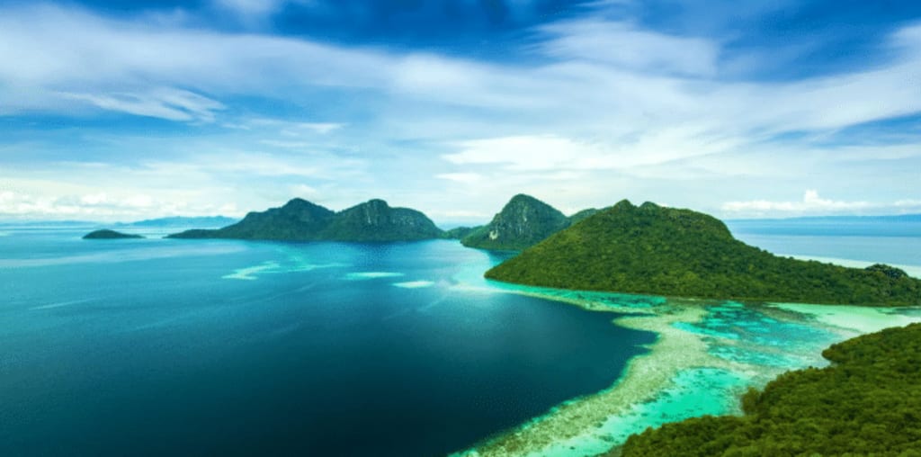
There is one such island in the South Pacific, which is located at 19.22° south latitude and 159.93° east longitude. This strange island in Australia and New Caledonia is known as Sandy Island, and the Thames World Map marks it as Sibor Island. The "Sandy Island" seen from the satellite map is very slender, like a giant hole in the Coral Sea in the South Pacific. The north-south length is expected to reach 16 miles, which is about 25 kilometers long, and the area is relatively large.
Although it has appeared in maps such as Google Earth for at least 10 years, and has existed for such a long time, but when scientists visit this area and want to see this strange island, they can't find any trace of it. . Some friends may think that the island itself may have existed before, but it was submerged by the sea or collapsed, so it disappeared from the sea, but when scientists conducted scientific research in this sea area, they found that in this area There are no islands in the sea at all, and the depth reaches more than 1,400 meters, which means that the statement that this island is haunted is basically ruled out.
Since the island could not be found at the scene, on November 26, 2012, Google Maps removed this strange island from the map, but the "Sandy Island" can still be seen in the satellite image of the seabed. exist.
If the island appears on the map, it may be the reason for an error in drawing the map, which would explain the situation where the island was on the map but not found on the spot. But the actual situation may not be as simple as imagined, because before there was no satellite map, there was news of this island.
The origin of Sandy Island can be traced back to more than 200 years ago, when British explorer Captain James Cook (Captain James Cook) drew a map of "Sandy 1 (Sandy I)" when he explored the northeast coast of Australia, This discovery was later published with Cook's book on South Pacific discoveries.
More than 100 years later, in 1895, the ghostly island was recorded again, and the data recorded at that time showed that the island was about 24 kilometers long, about 5 kilometers wide, and the size of the current satellite image. is relatively close.
If "Sandy Island" appears in the satellite image only because the staff made a mistake when drawing the map, or made a mistake on purpose, how to explain that someone saw this island nearby more than 200 years ago, more than 100 years ago? There were no satellite images more than 100 years ago. This is indeed very strange, and it can be said that it is still an unsolved mystery, which has puzzled scientists for a long time.
Five Solomon Islands have disappeared
The disappearance of some other islands may be less mysterious than the appearance and disappearance of Sandy Island. Because the terrain of some islands is very low-lying, as the climate warms, glaciers melt, and sea levels rise, some low-lying islands may be engulfed by rising sea water, which is not uncommon.
Scientists in Australia have found that as sea levels rise, five small islands in the Solomon Islands have disappeared, in addition to six small islands whose coastlines are rapidly shrinking under the impact of waves. The five islands that have disappeared so far are all uninhabited islands, which have a history of more than 300 years.
As sea levels continue to rise, more similar low-lying islands will be submerged and disappear from our view in the future. If it is some uninhabited islands, the situation may not be the most pessimistic. The worst thing is that some low-lying islands are inhabited. When the sea continues to rise, their houses will be damaged, and the people living on these low-lying islands will not be allowed to not leave their homes.
An island has been added to the east coast of Antarctica
As the climate warms and sea levels rise, some low-lying islands will be submerged, which is unavoidable in the context of climate warming. In the case of climate warming, not only are the islands submerged, but also some unknown new islands are constantly appearing. What is going on?
These new islands are not caused by changes in the earth's geological activities, but the islands themselves exist, but they were previously covered by thick ice sheets, and we couldn't find them. However, as the temperature of the earth continues to rise, these ice sheets and glaciers have accelerated the rate of melting. When the glaciers covering the islands have completely disappeared, the islands previously buried under the glaciers can be seen again.
The Landsat satellite took pictures of the east coast of Antarctica between 1989 and 2022, and scientists found that some ice shelves have disappeared and the coastline has been shrinking. At the same time, there was an object on the sea that did not recede, but remained in its original state. For this discovery, scientists said that the island should have been covered by ice sheets before, but now these ice sheets have receded, so the island is exposed.
The appearance of these islands is actually not good news, because the white snow and glaciers can reflect a lot of sunlight, and the surrounding temperature rise will not be particularly obvious, but when the white snow becomes land, these land reflect the sun The light is not so obvious, the land will absorb a lot of the sun's heat, eventually the temperature will rise, and the nearby glaciers will melt faster, causing more and more previously buried land to continue to be exposed.
Judging from the disappearance of several islands in the Solomon Islands and the emergence of new islands in Antarctica, as the climate continues to warm, some islands will disappear, and some islands will reappear. Whether it disappears or reappears, this is not good. information.
About the Creator
sondra mallen
Share a little bit of science every day
Keep reading
More stories from sondra mallen and writers in Earth and other communities.
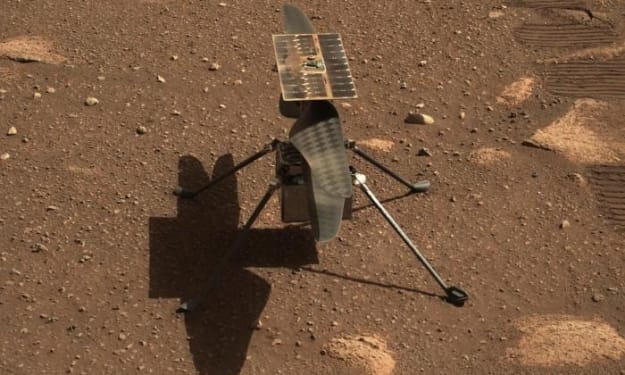
Scientists are terrified of the situation of the US Mars helicopter
Although Mars also has an atmosphere, the density of Mars' atmosphere is very low, only about 1% of that of Earth, which means that the air on Mars is very thin, and we can't breathe if we stand directly on the surface of Mars. It is also because the atmospheric density of Mars is very low that it is more difficult for those rotorcraft to take off on the surface of Mars. Not only the take-off weight of the rotorcraft will be limited, but also the rotational speed of the rotor is very high.
By sondra mallen2 years ago in Earth
A Journey into Bioluminescent Wonderlands
In the depths of the ocean and the darkest corners of the forest, a magical spectacle awaits those who dare to venture into the night. Bioluminescence, nature's light show, illuminates the darkness with a mesmerizing display of glowing organisms. From glowing jellyfish to luminous fungi, this phenomenon captivates both scientists and nature enthusiasts alike, offering a glimpse into the mysteries of the natural world.
By Muhammad Sarmad Razzaq5 days ago in Earth
Title: Bridling Renewables: Making ready for a Greener Future
In a world wrestling with the dire need to relieve environmental change and diminish dependence on petroleum products, sustainable power arrangements stand as encouraging signs for a reasonable future. From tackling the force of the sun and wind to taking advantage of the World's normal geothermal energy, sustainable power sources offer a spotless, plentiful, and unlimited option in contrast to customary petroleum derivatives. In this article, we investigate the groundbreaking capability of environmentally friendly power arrangements and their job in making ready for a greener, more supportable future.
By Albert phasha2 days ago in Earth
Death of a Salesman by Arthur Miller
Perhaps one of the best known modern plays in all of 20th century theatre, ‘Death of a Salesman’ is a 1949 play written by Arthur Miller. Set in Brooklyn, it takes place over two acts and portrays the tragedy of the Loman household - specifically that of protagonist Willy Loman. It deals with the crushing of the American Dream and forces the audience to confront the harsh truth about what America has become. It ended up winning the Pulitzer Prize for Drama and the Tony Award for Best Play and as it is revived many times we in literature and drama hope it can continue its influence for years to come.
By Annie Kapur2 days ago in Geeks


Comments
There are no comments for this story
Be the first to respond and start the conversation.