
How glaciers can shape the landscape
The effects can be seen many thousands of years after the ice has melted


Glaciers change the landscape in two ways, namely by what they take away and what they leave behind. These processes are termed glacial erosion and glacial deposition.
Although the term “glaciation” includes a range of processes such as the formation of ice sheets and icebergs, the word “glacier” should only be used to describe ribbons of ice that move down former river valleys (valley glaciers) or accumulations of ice on low-lying land at the foot of mountain ranges, resulting from the merging of adjacent valley glaciers (piedmont glaciers). Valley glaciers are more common, and it is their action that has the most dramatic effects in landscape change.
Glacial erosion by valley glaciers
Glaciers form when snow accumulates in such quantities in mountainous areas that it compacts into ice and its weight forces it to move downhill. Slight thawing during the day, followed by re-freezing at night, causes shattering of the bedrock and also provides lubrication for the mass of ice to start moving under the force of gravity. As it moves, the ice will carve out a hollow by removing the loose rock which is then borne away by the ice as it becomes the start of a valley glacier. More snowfall and ice compaction will provide a “reservoir” to keep the glacier supplied with material.
After the glaciation is over, several results of the above action will be seen. The hollow carved by the ice will have a steep back wall and possibly a raised lip that is evidence of the rotary action of the ice as it moves out. The hollow is variously known as a corrie, cwm or cirque. A small lake may be trapped behind the lip of the corrie, known as a tarn.

If two corries are formed next to each other, a sharp ridge of rock may be left between them. Such a ridge is called an arête. A Matterhorn peak can form when four corries are formed back to back with most of the mountain’s original bulk carved away by the ice to leave a sharp point behind.
Glaciers move away down existing river valleys and make major changes to them. The freeze-thaw action causes huge amounts of rock to be plucked off by the ice and be carried by the glacier which then acts like a massive piece of sandpaper wearing away the sides and floor of the valley, and thus causing yet more rock to break away. The scraping action of the rock fragments can be seen on valley sides as striation marks or smoothly polished surfaces. More resistant rock outcrops on the valley floor may become roches moutonées, with one side scraped smooth and the other left with a steep jagged scarp slope as the ice has plucked at it in passing.
The weight of the ice bears down evenly across the width of the glacier, so that downwards erosion also takes effect across the full width. This is different to the way river water erodes a valley, with the main effect being concentrated at a central point and material falling down into the river to be carried away. A river valley is therefore typically V-shaped in profile, whereas a glacier valley is U-shaped, with steep walls and a level floor.
Like rivers, glaciers often have tributaries, but the smaller tributary glaciers, having less weight and erosive power, will not dig down as deeply as the main glacier. When the ice melts and normal drainage resumes, these side valleys will be left as “hanging valleys”, with their rivers descending via waterfalls to the floor of the main valley.

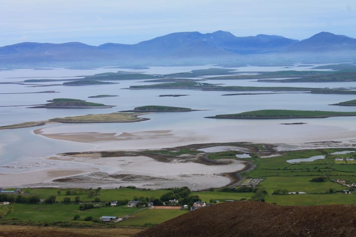
The glacier is unlikely to erode its floor in a perfectly smooth manner, such that, when it melts, lakes will form in the hollows left behind, especially when the glacier deposits material further down the valley. These lakes can be very long and deep, due to the overdeepening caused by the ice as it moves across more easily eroded rock. Lakes created by this process are referred to as ribbon lakes and include the inland lochs of Scotland and the lakes of England‘s Lake District. In time, such lakes will be filled in by debris washed down from the surrounding hills, an intervening stage being the separation of single lakes into strings of smaller ones. Such strings of lakes are known as pasternoster lakes due to their resemblance to a string of beads on a prayer rosary.
When a glacier reaches the sea it is likely that the whole valley will flood after the period of glaciation is over and sea levels return to normal. The result is a fjord, the most majestic of these being found in Norway, New Zealand and the north Pacific coast of North America.
Glacial deposition
This occurs with both valley and piedmont glaciers. When a glacier melts it will leave behind the rock fragments carried underneath, within, in front and on top of it. The general name for this material is moraine, and various types of moraine have been identified depending on its final position. For example, lines of moraine left along valley sides is known as lateral moraine, and if two glaciers have joined they may create a medial moraine down the centre of a valley that is actually the lateral moraines of the two original glaciers.

Glaciers and ice sheets can transport rock for many miles and leave it at any place where it becomes too heavy to move further due to the ice melting. Such pieces of rock that are geologically in the wrong place, in that the surrounding rock is of a different type, are known as erratics. There are, for example, rocks in eastern England that should really be in Norway.
When glaciers emerge on to lower land as piedmont glaciers, and then melt, they can deposit large amounts of rock as terminal moraines. These can in turn disrupt the natural drainage pattern of the region and create lakes that are dammed by the moraines.
As melting takes place, small streams will wash material from moraines to places far beyond the original limit of the ice to form outwash fans and outwash plains.
Lowland landscapes that have been covered by glacial ice will display many features that are evidence of change, although some of these will be the result of ice sheet coverage rather than glaciers as such. However, when several piedmont glaciers come together the effects can be similar to those of ice sheet coverage.
The surface deposits are known as boulder clay, which comprises fragments of unsorted rocks of various sizes in a clay matrix. The boulder clay is sometimes shaped into low hills known as drumlins and depressions are filled with water to become shallow kettle lakes. Streams that form from melting glacial ice may deposit sand and gravel that later forms eskers that snake across the countryside.
A landscape that has been subject to glaciation is unmistakable, whether highland or lowland. Although the last major ice age in the Northern Hemisphere ended 50,000 years ago, its effects are still evident in the landscapes visible today.
About the Creator
John Welford
I am a retired librarian, having spent most of my career in academic and industrial libraries.
I write on a number of subjects and also write stories as a member of the "Hinckley Scribblers".
Keep reading
More stories from John Welford and writers in Earth and other communities.
We need to fly a lot less
It is well known that transport is a major contributor to greenhouse gas emissions, mainly due to the fact that most forms of transport are powered by fossil fuels, the burning of which leads to the release of carbon dioxide and other waste products, some of which are also greenhouse gases. In the UK, for example, 22% of greenhouse gases come from road vehicles.
By John Welford3 years ago in Earth
Spotting this laser beam? Brace yourself—lightning might be lurking close by!
Lightning, with its spectacular display of power, is a natural phenomenon that never fails to captivate our imagination. When it strikes, it unleashes an incredible 300 million volts of electricity—enough to power 25 million car batteries! What's even more astonishing is that you're statistically more likely to be struck by lightning in your lifetime than to win the lottery. It's a reminder of the unpredictability of nature and the need for innovative solutions to protect against its forces.
By Esha singh5 days ago in Earth


Comments
There are no comments for this story
Be the first to respond and start the conversation.