
500 YEAR OLD MYSTERIOUS MAP REVEAL DETAIL ABOUT EARTH
The Peter Ease 500 year old mysterious map reveal detail about EARTH

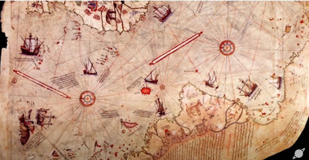
The enigmatic Peter Ease map is just one of several unusual maps created during and before the sixteenth century. Some individuals argue that it provides more accurate information about the shape of the world's continents than what was known at the time. This assertion has led to even more remarkable claims that the geographical data presented on the Piri Reis map could have been obtained at a much earlier time and was based on knowledge from an advanced, yet unknown, ancient civilization. Discovered in the Topkapi Palace library in Istanbul on October 9th, 1929, by a German theologian named Gas Dog a Dog Diceman, the map was drawn and signed by Turkish cartographer Ahmed Muhiddin Piri, also known as Piri Reis. In addition to his cartography work, Piri Reis was an accomplished sailor and served as an admiral in the Turkish Navy. The map is dated 919 in the Islamic calendar, which corresponds to 1513 CE in the Western calendar. While constructing the map, Piri Reis claimed to have used up to 20 source maps and charts, including eight Ptolemaic maps, four Portuguese maps, an Arabic map, and a map purportedly created by Christopher Columbus.
Apart from its significant historical significance, the Piri Reis map has been claimed to contain information that no European could have known during the 16th century. This has led some to believe that it is tangible evidence of the existence of ancient technological civilizations and extraterrestrial visits, which has sparked controversy in both academic and non-academic circles. The map's extraordinary detail of coastal outlines has been a subject of intense debate regarding the attribution of its source materials and significance. Dr. Charles Hapgood ignited the great debate when he published his theory on the Piri Reis map in his 1966 book, "Maps of the Ancient Sea Kings." Dr. Hapgood, a historian educated at Harvard, was admired by the likes of Albert Einstein for his theories on geological shifts. Dr. Hapgood and a team of students at the University of New Hampshire studied the Piri Reis map and claimed to have found many anomalies, including the alleged representation of the continent and Arctic on the map.
The incorporation of the continents' cream model and area on this map is exceptionally fascinating as it is believed that Antarctica was discovered in the 19th century, hundreds of years after the creation of the Piri Reis map. The controversy surrounding the map is not only about how the 16th-century Turkish cartographer managed to draw an exact map of the Antarctic region 300 years before its supposed discovery, but also how the map depicts the landmass and coastline of the Antarctic region before it was covered in ice over 6,000 years ago.
In 1961, Captain Lorenzo W. Bortles, a US Air Force captain working in the cartographic section, wrote a letter to Dr. Hopgood and stated that the Antarctica depicted on the Piri Reis map appears to accurately depict the coastline of Antarctica as it is under the ice. The captain based his evaluation on the seismic profile of the Queen Maud Land area made by the Norwegian-British-Swedish expedition of 1949.
Because of this alleged anomaly, Hapgood proposed that the Piri Reis map was actually based on the source materials that predate 4000 BCE, thousands of years before the earliest known progressive civilization with developed languages existed. With Hapgood's extraordinary theory, one glittering and compelling question is raised: which unknown civilization had the technology and need to map the Antarctic regions 6,000 years ago? Well, according to Hapgood, a prehistoric civilization possessed the technology to navigate major seaways and chart the globe with some level of accuracy. What's more, he also suggested that the topographic depiction of the interior of the continents required aerial capabilities. This implies that a prehistoric super-civilization with aerial and nautical capabilities was the origin of the Piri Reis map's geographic information on the pre-ice Antarctica.
In his book, Dr. Hopgood said this about the possibility of ancient voyagers exploring the Antarctic: "It becomes clear that the ancient voyagers travelled from pole to pole. Unbelievable as it may appear, the evidence nevertheless indicates that some ancient people explored when its coasts were free of ice. It is clear too that they had an instrument of navigation for accurately determining the longitude that was far superior to anything possessed by the peoples of ancient, medieval, or modern times until the second half of the 18th century."
For Hapgood and his supporters, the Piri Reis map could indicate advanced knowledge passed the pillories map, constructed in 1513, displays an impressive level of detail, despite its flaws. It is a prime example of naval intelligence gathering and cartography, with specific details that could have been obtained from enemy maps' guarded secrets. Some experts argue that the most beautiful part of the map is the South American coastline, which accurately depicts the modern physical features of the region. However, others, such as Gregory C McIntosh, suggest that the southern continent shown on the map is a product of imagination. This idea of a southern continent has been discussed since ancient Greek times, and many maps since have depicted it in various forms. Therefore, it is not surprising that the pillories map also includes a southern continent. The depiction of this southern landmass on the pillories map may be a misguided representation of South America, an imagined portrayal of a mythical southern continent, or perhaps even an ancient depiction of the Inte Arcticus Coast, hinting at the existence of a sea-faring civilization thousands of years ago. The truth may never be known.
About the Creator
Shantall Addison
Hi there! My name is Shantall and I'm a freelance writer. I have been pursuing my passion in storytelling for sometime now . I specialize in writing about travel and fictional stories, I hope you find my work fun, interesting and exciting.
Enjoyed the story? Support the Creator.
Subscribe for free to receive all their stories in your feed. You could also pledge your support or give them a one-off tip, letting them know you appreciate their work.
Keep reading
More stories from Shantall Addison and writers in Earth and other communities.
Surviving a Post-Apocalyptic Event
The sun was setting on a desolate wasteland. The once-bustling city was now nothing more than a graveyard of concrete and steel. The streets were empty, except for the occasional abandoned car, and the air was thick with the scent of ash and decay. It had been five years since the world had ended.
By Shantall Addisonabout a year ago in Earth
How to Make Your Home Energy Efficient
How to Make Your Home Energy Efficient Making your home energy efficient is one of the best ways to reduce your environmental impact and save money on energy bills. With rising energy costs and growing concerns about climate change, adopting energy-efficient practices has never been more important. Here are practical steps you can take to make your home more energy efficient and eco-friendly.
By Joseph Elishiabout 10 hours ago in Earth
The Environmental and Ethical Impact of Vegan Food
Introduction Hey there! Have you ever thought about going vegan or just curious about what vegan foods are all about? Whether you're a seasoned vegan or just starting out, this guide will help you understand Vegan Food and how to buy them online, specifically focusing on Vezlay Foods, a fantastic option for all your vegan needs.
By Vezlay Foods6 days ago in Earth


Comments (1)
Interesting information