
MOUNT KANLAON IN THE PHILIPPINES ERUPTION
MOUNT KANLAON IN THE PHILIPPINES ERUPTED LAST JUNE 23, 2024

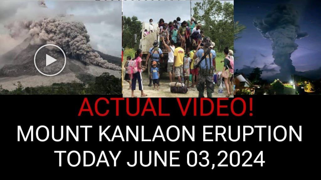
At 6:51 p.m. local time on June 3rd, 2024, Mount Canlaon in the Philippines underwent its most substantial eruption ever recorded. An immense ash plume swiftly ascended into the sky, triggering the collapse of part of the eruption column, which in turn generated pyroclastic flows. These superheated streams, carrying volcanic material at temperatures of up to 800°C, raced down the slopes at speeds exceeding 120 km/h, traveling as far as 3,000 meters before dissipating just two minutes later. Alongside these flows, large lava bombs, some as big as cars, and other glowing materials were ejected.
Within six minutes of the eruption's onset, it culminated with an ash plume reaching an altitude of 7,620 meters (25,000 feet). Aviation warnings were promptly issued via volcanic ash advisories, cautioning that airborne ash could reach altitudes of up to 8,839 meters (29,000 feet) in the subsequent 12 hours. The fallout of wet ash was observed in several towns located west and southwest of Canlaon, characterized by a sticky, clay-like texture and light gray coloration, a result of volcanic rock alteration influenced by nearby magma or magmatic gases.
This eruption not only stands as Canlaon's largest on record but also marks only its third magmatic eruption since systematic monitoring began. Historically, of the 27 eruptions recorded since 1900, most were phreatic, caused by groundwater rapidly converting to steam due to increased heat from underlying magma. This process builds pressure until it explosively ruptures the overlying rock.
The appearance of erupted lava suggests that the magma may be shallower than previously thought, hinting at potential for ongoing eruptive activity in the coming days, weeks, and possibly months. While past eruptions at Canlaon have often been isolated events, magmatic eruptions have typically occurred in prolonged sequences lasting from weeks to months.
Fortunately, initial reports indicate no casualties, although concerns linger regarding potential damage to farmland within the volcano's established 4-kilometer exclusion zone around its summit. Evacuation orders were issued for communities situated on Canlaon's slopes, with ongoing monitoring signaling the possibility of additional, though potentially smaller, eruptions in the near future.
This eruption, while significant, did not entirely catch observers off guard, given Canlaon's recent signs of unrest over the past year. These indicators included ground deformations, elevated sulfur dioxide emissions—indicative of shallow magma—and frequent seismic activity. The eruption is believed to have been triggered by a blockage forming in Canlaon's magma conduit, coinciding with a reduction in observed sulfur dioxide emissions leading up to the event.
In response to these developments, authorities swiftly raised Canlaon's alert level from 1 to 2, underscoring ongoing vigilance and preparedness in the face of volcanic activity.
Additional Information:
Mount Canlaon, a stratovolcano located on the island of Negros in the Philippines, has a history of periodic eruptions, typically characterized as steam-driven or phreatic eruptions caused by groundwater flashing to steam due to heat from underlying magma. However, magmatic eruptions, where molten magma reaches the surface, are less frequent but more significant in terms of volcanic hazards. The recent eruption's scale underscores the dynamic nature of Canlaon and the potential risks it poses to nearby communities and agriculture.
The volcanic ash fallout from the eruption poses risks not only to air traffic but also to respiratory health and agricultural productivity. Ashfall can disrupt transportation, contaminate water sources, and damage crops and livestock. Local authorities and disaster response teams are likely mobilizing to assess and mitigate these impacts, ensuring that affected communities receive necessary support and resources.
Scientific monitoring of Mount Canlaon will intensify in the aftermath of this eruption, with geologists and volcanologists closely observing changes in seismic activity, gas emissions, and ground deformation. These monitoring efforts are crucial for early detection of renewed volcanic activity and for issuing timely warnings to protect lives and property.
The eruption serves as a reminder of the Philippines' vulnerability to volcanic hazards, given its location along the Pacific Ring of Fire, where tectonic plate boundaries converge, leading to frequent seismic and volcanic activity. Preparedness, public awareness, and scientific research are essential components of mitigating risks posed by such natural events in the future.
About the Creator
Inie Hermedalla
Hi I'm Inie a budding writer with a passion for exploring new ideas and telling compelling stories.
Enjoyed the story? Support the Creator.
Subscribe for free to receive all their stories in your feed. You could also pledge your support or give them a one-off tip, letting them know you appreciate their work.
Keep reading
More stories from Inie Hermedalla and writers in Chapters and other communities.
A ship lost for 132 years discovered beneath a cornfield
Two intrepid treasure seekers were excavating frozen ground in a cornfield on a rainy night, with lightning flashing all around them. Despite the adverse conditions, they continued their work undeterred. Suddenly, their shovels struck something solid. Could it be? A treasure chest buried deep beneath the Kansas City fields? Not quite. Instead, they unearthed a piece of a ship's engine, a surprising discovery far from any seas or lakes.
By Inie Hermedalla12 days ago in Chapters
The Glenwood Mystery Killer | Episode 9
**Chapter 9: Revelations** The revelation sent shockwaves through the university community. Dr. Myers and his accomplices were arrested, and the cryptic society dismantled. As the campus began to heal, Emma graduated with honors, while Alex landed a prestigious internship. They remained inseparable, their bond forged through adversity. The memories of the mystery and their role in uncovering the truth would forever be etched in their hearts.
By Daily Readabout 7 hours ago in Chapters


Comments
There are no comments for this story
Be the first to respond and start the conversation.