
I Surveyed China’s Pinglu Canal in 1968. Fifty-Eight Years Later, I Watched It Open.
Seven men, one old map, and the 134-kilometer waterway that finally connected Southwest China to the sea.
Pinglu Canal: A River a Century in the Making, How It Pushes Southwest China to the Sea
How a 1968 survey team’s idea became a 5,000-tonne waterway to Beibu Gulf in 2026
On the morning of September 16, 2026, the tides stirred in Qinzhou Bay. The Pinglu Canal opened to navigation.
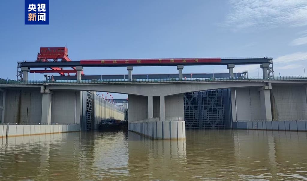
The first 5,000-tonne freighter left Pingtang River mouth in the Xijin Reservoir area of Hengzhou City, Nanning. It passed through the three cascade hubs of Madao, Qishi, and Qingnian, then followed the Qinjiang River south to Beibu Gulf. The canal runs 134.2 kilometers, meets Class I inland waterway standards, and carries 5,000-tonne ships. It set four global records. From that day, Guangxi’s inland rivers and the sea no longer sit on opposite sides of a watershed.
That moment came 58 years after seven men carrying theodolites walked into the wild mountains in the early autumn of 1968.
I. In 1968, Seven Men Walked into the Watershed
In 1968, I was 34 and working as a technician in the Shipping Division of the Guangxi Department of Communications. One day, the department told me that Mr. Weng Changpu had asked for me by name and wanted me in his office.
Mr. Weng was in his forties or fifties, from Sichuan, and very serious. Technicians and engineers at the Xijin Hydropower Station were afraid of him. He was chief technical adviser to the Guangxi government and chief engineer of the Xijin Hydropower Station. He explained his idea: the Xijin Hydropower Station had been completed in 1964. The water level upstream was more than 60 meters above sea level, and the reservoir backwater had reached the foot of the watershed. If a canal were dug from there, cutting through the watershed in twenty or thirty kilometers, connecting to the Qinjiang River, and then following the old Qinjiang channel downstream for more than eighty kilometers, it would reach Qinzhou Bay. Guangxi’s inland rivers could connect directly to the sea.
We worked in inland waterway transport. After so many years, we had never considered connecting to the sea. Guangxi had no sea before. In 1965, the Qinzhou region was transferred from Guangdong to Guangxi, and only then did Guangxi again have its own outlet to the sea. Now the Xijin Hydropower Station had raised the Xijiang River’s water level, and Qinzhou’s sea outlet had come under Guangxi. Mr. Weng’s plan was bold.
After hearing it, I was shaken. Bordering the sea but not connected to it was an enormous constraint. If we could connect the river to the sea, it would benefit Guangxi, the entire Southwest, and future generations.
We set to work at once. Within two or three days, we had assembled a team and set out to survey. The survey team had seven people. We carried a plane table, a level, and a theodolite on our backs and shoulders. Looking back, our equipment was crude. We did not even have a decent topographic map. We used an old 1:50,000 map left over from the old society.
We took a boat from Nanning to Pingtang River mouth and got off. The watershed was exactly where the largest Madao hub and ship lock of the Pinglu Canal now stand. We began surveying from the watershed toward the Qinjiang River. The whole route was wild mountains and ridges. Carrying our instruments, we relied on our legs, making a cross-section every fifty meters and pushing forward bit by bit. A day’s progress of five kilometers or ten li was good. We had no decent rain gear, only straw hats. Our clothes would be soaked through, and we kept working. The hardest part was eating. In the wild mountains there was no food. There were no instant noodles then. We endured it. Only when we passed through a town could we eat a bowl of rice noodles.
We had a song, “The Surveyor’s Song,” and we often sang it. People of that era were like that: given a task, they did it, steadily and solidly, without thinking too much about anything else.
We worked in the field for about half a month. After the field work ended, we returned to Nanning and set up a temporary office in the Communications Design Institute to do calculations, drawings, planning, and design. At that time, we designed it as a 1,000-tonne waterway. From the dead water level of the Xijin Reservoir to the sea, the total drop was 60 meters, and we planned six cascade ship locks. The canal required 25 kilometers of new excavation, reaching a navigation standard of 80 meters wide and 2.5 meters deep. Then we would use 80 kilometers of the existing old Qinjiang channel to reach Qinzhou Bay.
I did the economic assessment. To build a canal, you also have to do the economic math. What could be transported after the canal was completed, and whether it was worthwhile, was the most important question. At that time, the main goods coming in were Hongay coal from Vietnam, rice, fruit, and aquatic products. The goods going out were Guangxi cement, building materials, minerals, and machinery from Liuzhou. After surveying the data and calculating back and forth, we found that the traffic volume at the time was only about ten percent of the canal’s capacity. Even in twenty years, it would be difficult to reach the designed traffic volume. Under the technical conditions of the time, building this canal would require 200,000 laborers and five or six years of work. Along the route, it would also cross two provincial highways and the railway to Beihai, requiring two or three overpasses. With such a large investment, and with cement, steel, and timber all in short supply, and with financial and material resources limited, the amount that could be transported was small. It was not worthwhile.
So we wrote the conclusion clearly in the report: technically feasible, the vision would surely be realized, but not suitable to launch at that time.
I reported this conclusion directly to Mr. Weng. He said: “All right, you did well. You blazed a trail. It looks like this canal can be built.”
The report was submitted to the Planning Commission and the Department of Communications. The matter was then shelved for decades. But I did not feel regret. The canal’s feasibility was not in question. Technically it was workable. Knowing that Guangxi’s Xijiang River could connect to the sea was enough. We only made a start and blazed a trail. The rest was for the next generation.
II. On a 65-Meter Drop, Building a Water Elevator
Half a century later, when construction began, the engineering challenge behind that judgment of “technically feasible” became clear.
The Pinglu Canal is 134.2 kilometers long, with a total water-level drop of 65 meters, equivalent to a building of more than 20 stories. Without intervention, such a drop over more than 130 kilometers would make the current too turbulent, and ships could not navigate safely.
The builders laid out three cascade hubs along the canal from top to bottom: Madao, Qishi, and Qingnian. They broke the 65-meter total drop into stages. The maximum water-level difference between upstream and downstream at the Madao hub reaches 29.6 meters, equivalent to a ten-story building, making it the most difficult node on the line. The lock chamber is 300 meters long and 34 meters wide. One lock chamber is equivalent in area to 1.5 standard football fields.
The ship locks also open and close fast. The 70-tonne giant valves achieve the world’s fastest opening and closing speed: “open in one minute, close in 30 seconds,” two to four times faster than conventional ship locks. The maximum navigation head at the Madao hub reaches 29.6 meters. The lock gates are more than 20 meters high and weigh over 1,000 tonnes. They have to be hoisted into place. Hoisting them was its own problem.
Water was the second problem. Rainfall in Guangxi is concentrated from April to September, and water resources are tight in the dry season. Traditional ship locks consume a large amount of water every time a ship passes. If water were simply discharged and released directly, the canal would be hard to sustain in the dry season. The Madao and Qishi hubs adopted water-saving ship lock designs. When a ship goes downstream, the water in the lock chamber is stored in high-, middle-, and low-level storage ponds. When a ship goes upstream, the water is returned and reused. With one operation, each lockage saves 60 percent of water. Along the entire line, more than 1 billion cubic meters of water are saved each year.
The earthwork was huge. The total excavation of earth and rock for the Pinglu Canal reached 315 million cubic meters, nearly three times that of the Three Gorges hub. Back then, one person could dig one or two cubic meters of earth a day. With 200,000 workers, it had to be done with one hoe and one basket. Now, in different contract sections, tens of thousands of cubic meters can be excavated and transported in a day. The Tianjing cutter-suction dredger can grind rocks on the seabed like tofu. There is no comparison.
Ecological protection was also a hard constraint. The canal’s sea outlet is adjacent to the Maowei Sea Mangrove Reserve. The project team voluntarily rerouted the canal for the mangroves, transplanting more than 9,500 native mangrove trees. For the parts within the red line that could not be preserved, off-site restoration was carried out at three times the area, with a restoration area of 32.3 hectares. At the Qingnian hub, a 480-meter dual-channel fishway was built, allowing fish whose migration had been interrupted for more than 60 years to find their “way home” again.
The Pinglu Canal set four global records: the strongest navigation capacity among similar canals, the fastest navigation speed among similar ship locks, the highest water head for a water-saving ship lock, and the largest inland water-saving ship lock.
The work was more than excavation. It meant building a water elevator on a 65-meter drop, a circulating water system in a dry region, and a green corridor through a sensitive area.
III. From 1,000 Tonnes to 5,000 Tonnes, Generation After Generation
That 1968 Pinglu Canal Survey and Planning Report could later no longer be found. Too much time had passed, and generation after generation of people had come and gone. The original report could not be found. Guangxi Television tried to look for it but could not find it.
But the work on the canal did not stop.
By the 1990s, the Pinglu Canal was raised again. By then I had been transferred to Guangdong. I heard that the Department of Communications had organized another survey, far more detailed than ours, and had also done geological drilling in the watershed section. The team leader was my old colleague Qin Xinjun. He passed away a few years ago. Later he became a strong advocate for the canal, but in the end it still did not happen. I understood: it still came down to economics. In the 1990s, Guangxi was still not ready.
Another twenty or thirty years passed.
In 2021, I saw on the news that the Pinglu Canal had been formally approved. I told my friends and family: I have finally lived to see it.
On August 28, 2022, construction began. On September 16, 2026, it opened to navigation.
More than fifty years. From the first time we set foot in those wild mountains to now, more than half a century has passed. Many of that generation, including Mr. Weng, our seven survey team members, and colleagues and friends in the industry, are no longer here. But the work on the canal never stopped. Generation after generation, people kept the idea alive through proposals and feasibility studies. Each generation did what it should do in its own place.
Now that it is open, looking back, our vision then cannot compare with what it is now. We designed it for 1,000 tonnes; now it has been raised to 5,000 tonnes. This delights me. A 5,000-tonne ship can sail directly in coastal waters, from Qinzhou Bay to Hong Kong, Vietnam, and Thailand, without transferring to a larger ship. It is much more flexible. The ship locks have been reduced from six levels to three. The maximum navigation head at the Madao hub reaches 29.6 meters. The lock gates are more than 20 meters high and weigh over 1,000 tonnes. They have to be hoisted into place. Hoisting them was its own problem.
Do I envy them? Of course. I am also happy, and moved. In our era, limited by conditions, we knew clearly that this could be done, but it could not be done. Who could have imagined then that fifty years later China’s total output could reach such a scale, and China’s engineering capability could become what it is today? If someone had told me in 1968 that this canal would one day be built to 5,000-tonne class, I would have called it a fantasy.
IV. Cutting 560 Kilometers, and Then What?
The most direct effect of the Pinglu Canal is spatial compression.
After opening, goods from the Southwest going to sea through the Pinglu Canal will shorten their inland voyage by more than 560 kilometers compared with traditional routes, saving more than 5 billion yuan in transport costs each year. Overall logistics costs are expected to fall by 18 to 30 percent. Voyages to major ASEAN ports will also be greatly shortened. For example, transporting goods from the western inland to Singapore can shorten the voyage by up to 740 kilometers.
This cost-reduction effect already appeared before the canal opened: from January to August 2026, cargo throughput at Beibu Gulf Port grew by more than 40 percent year on year. Beibu Gulf Port has completed adaptive renovation of 13 river-sea intermodal berths, adding about 32 million tonnes of river-sea capacity, including 800,000 TEUs.
Signs of industry clustering along the canal have also appeared.
In Guigang, the Pinglu Canal Economic Development Zone signed 10 new projects in 2025, with a total investment of about 13.3 billion yuan. Five of them were signed and started in the same year. The total output value of industrial enterprises above designated size in the zone grew by 18.5 percent year on year. In Qinzhou, Shanghai Huayi Group laid out an integrated chemical new materials base with a total investment of about 100 billion yuan. Guangxi Jingui Pulp & Paper is also planning to build a wharf along the canal so that raw materials such as wood and calcite can reach the factory directly by water. In Nanning, the output value of the new energy battery industry has exceeded 130 billion yuan. Enterprises import spodumene through the canal, saving more than 10 million yuan a year in freight alone.
Upstream cities are also actively connecting. Baise has made clear that it wants to become the “first cargo source port” of the Pinglu Canal. The total industrial output value of its four leading industries (new eco-aluminum, forestry, new energy, and new materials) has exceeded 250 billion yuan. A person in charge of Geely Baikuang Group calculated that for coal alone, water transport can reduce the transport cost by 20 yuan per tonne. Baise also hopes to use the canal to change the situation in which 70 percent of its aluminum industry consists of primary products, and to extend toward higher value-added processing.
But the test is where the cargo will come from.
In the early period after the Pinglu Canal opens, a considerable part of its cargo will need to be diverted from the existing Xijiang waterway. But the chokepoint of the Xijiang eastward route, the Changzhou Ship Lock, is already overloaded and has no room for expansion. Diversion is necessary. Long-term cargo growth depends on whether new industries can grow along the route.
There are three core challenges. First, the industrial base in the western Guangxi hinterland is relatively weak, and in the short term local cargo suited to water transport may not be enough to support traffic. Second, upstream waterways such as the Youjiang River are currently only 1,000-tonne class, which does not match the canal’s 5,000-tonne main line. Upgrading projects are still in the early stages. Third, wharves along the route are not large-scale or specialized enough, road-rail-water intermodal connections are not smooth, and collection and distribution facilities such as rail spur lines into ports lag behind.
In addition, Guangxi has long faced the problem of population outflow. The root cause is an overemphasis on heavy chemical industry and insufficient labor-intensive manufacturing. The canal’s value lies in creating conditions for taking over industrial transfers, keeping jobs and people local, rather than merely becoming a transit corridor.
The Houston Ship Channel offers a comparison. Excavation began in the early 19th century, and for decades afterward it was continuously deepened and widened. What were the first years after it opened? In 1917, annual cargo throughput was only just over 1 million tonnes. In 1987, I saw with my own eyes in Houston 10,000-tonne ocean-going ships queuing to enter port, one after another. Now, more than a century later, it is the largest port in the United States by cargo tonnage. In 2024, its public terminals alone handled more than 53 million tonnes of cargo and over 4.1 million TEUs.
A canal needs time to prove its value.
V. A Long-Term Project
Now some voices online say that the investment of more than 70 billion yuan is too high, that traffic volume is insufficient, and that it is a losing business. I have some views on this.
This is a long-term project. Judging it by first-year traffic misses the point.
The Pinglu Canal and the railways and highways of the New Western Land-Sea Corridor complement each other. They build a multimodal transport system, gather cargo from the Southwest, activate regional economic vitality, and improve the logistics efficiency of the New Western Land-Sea Corridor. The canal shortens the route from the Southwest to the sea. It also strengthens the New Western Land-Sea Corridor and China-ASEAN trade.
Can it lift Southwest China? In the short term, the 560-kilometer shorter voyage and the 18 to 30 percent reduction in logistics costs are tangible dividends. In the medium term, signs of industrial clustering along the canal have already appeared. In the long run, the waterway’s value depends on whether a competitive industrial belt can grow along its banks.
The canal does not create cargo by itself. It lowers the cost of moving it. The cargo still has to be produced. It gives the Southwest a shorter route to the sea. Whether that route becomes an industrial corridor depends on what gets built along it.
In recent years, newspapers and television have reported on the Pinglu Canal more and more frequently. Every time I see it, my heart warms. Now it is built and open. Both it and I have waited long enough to see this day.
My health is still okay, though my legs are not so good. I plan to drive with my family to see the canal. First to Madao, the unforgettable watershed we surveyed back then. Now the country’s largest inland-to-sea hub is there. Then to Luwu Town, where we ate a few bowls of rice noodles. Then along the canal, to see what the road we walked has become.
More than fifty years, from wild mountains to a 5,000-tonne waterway. The Pinglu Canal measures the distance China has traveled from the ability to imagine to the ability to build. It also connects the Southwest hinterland to the sea.
Guangxi now has a direct river-sea connection. The Southwest now has a closer sea.
The canal is open. The first ships are moving. The next question is what they carry.
About the Creator
Jin
Writer of reamstories
https://reamstories.com/jin
Enjoyed the story? Support the Creator.
Subscribe for free to receive all their stories in your feed. You could also become a paid subscriber, letting them know you appreciate their work.
Comments
There are no comments for this story
Be the first to respond and start the conversation.