
Boquillas, Border Town Without a Border
Day Six of Camping and Hiking in Big Bend National Park
We woke up a little bit after sunrise. It felt good, having slept in the cool night air without the fly on the tent. Even though both our bags are much warmer than we needed, even as exposed as we were, it was nice to have the cooler air on my face. And nice to wake up relatively free of sand. Of course there’s no escape from the sand entirely.
I broke down camp while Ian boiled water and made oatmeal for breakfast. The tent, food and other stuff got just sort of stuffed into the back of the car. No hiking planned for the day, just a low-key visit to Boquillas while my hip recovered. So we brushed our teeth, stopped by the camp store to toss our trash and drove the hour or so to the border patrol station inside the park.
The station is on the southeast corner of the park, about 200 meters from the river. Inside is a single agent, and he checks that we have our passports—necessary to get back—and reminds us that it will cost us $5 per person to be ferried across the river. Then we proceed out of the station and down the short trail to the river, where a man on the Mexican side rows across the river to pick us up. He reminds us that it’s $5 each and we agree. I suppose our other option would be to swim across.

On the other side of the river men offer us tours of the area in their trucks, rides into town on their donkeys. We decline, opting instead to walk the half mile or so into Boquillas. We’re not even halfway there when we see a few tables set up along the side of the road, the women behind the tables selling bags, hand towels and doilies with different animals embroidered on them. A bunch of the stuff had “no wall” stitched onto it.

We took our time walking into town. It’s small and a little spread out. There isn’t much to see. Concrete houses, the exterior paints faded from years and years in the sun and summer heat. Our wandering stopped when I began to feel like we had come into a part of the town that was entirely residential. It didn’t feel right to tromp all around the place where the people there actually lived. So we turned around and went back to the main little stretch of road where the bar, restaurant and church are.
We picked a restaurant to have lunch at. The patio offered a view of the Rio Grande. Down the hill we could see the waters winding their way through the sand and trees. It looked to be about six feet across, easily crossed with a running leap. The food was good, a welcome break from the boil-in-bag camp food we would have been eating otherwise, but was largely unimpressive. More richly flavorful Mexican food can be found in Houston, which isn’t surprising. Boquillas feels like a tourist’s town. The local economy depends on tourist dollars, but there is still the strange feeling that the town fits too well into what the general American perspective on what Mexico looks like. On our way out of town we each bought a few things from the street vendors, packed them into our backpacks and headed back across the river.

In the border patrol station, the agent directs us each to a kiosk where we scan our passport and talk to an agent over the phone stationed in San Antonio. They ask if we are bringing anything back with us, and then tell us we’re good to head back into the park.
We had a campsite reserved on the east side of the park, only ten miles or so north of the crossing. It was only noon, so we had lots of time before we needed to set up camp. We opted to take a drive over to the west side of the park, an area where we didn’t have any planned camping or hiking.
So we took the paved road to Panther Junction, filled up on gas and water, then continued on west, eventually following the road south to Castolon. It was early afternoon and blazing hot. With little wind and less shade, the west side of Big Bend was unforgiving, even in the AC of the car. We stopped at Castolon, an old army barracks built during the Mexican Revolution for American troops. It has since been converted to a museum and small convenience store.
[A couple months after we left Big Bend, a wildfire which began on the Mexican side of the river crossed the Rio Grande and burned the barracks buildings here.]
We didn’t stay in Castolon very long, but turned west on the paved road, keeping our eyes on the Santa Elena Canyon as it grew larger and larger. We were able to see these cliffs and the canyon itself on the horizon from our first campsite at Talley 2 It seemed impossibly far away at the time. Yet there we were, driving within a quarter of a mile of the entrance to the canyon. In a few days, we would be driving along the rim of the canyon, hundreds of feet above the Rio Grande, on our way to the state park. But for the time being we turned north, onto the unpaved Old Maverick Road towards Maverick Junction, the western entrance to the National Park. It took us half an hour to travel the 13 mile dirt road, only seeing one other car.

From Maverick Junction it was back east on the paved road, then a north at Panther Junction as though we were leaving the park. But we only headed 26 miles before turning onto the unpaved Dagger Flats Auto Trail, a 7 mile unpaved road which terminated at the Dagger Mountain Scenic Overlook. At the end of the trail we got out of the car, looked at the unimpressive Dagger Mountain for a few minutes, then climbed back into the car to head partway back down the Auto Trail.
Our campsite was some 20 miles south along Old Ore Road, a very rough 4x4 road that meanders through the dessert hills, dipping into narrow valleys and bumping along the rims of mesas over a total of 26 miles. We only needed to travel 21 miles. Ian crawled the car over rocks, loose gravel, twisting switchbacks down hillsides and steep inclines up and over sudden lifts in the terrain. We stopped to pee and take in the view atop a long canyon, pointing out Mariscal Mountain in the distance, and the Chisos Mountains west of us.

Atop mesas and in wide valleys the ground flattened out and blue bonnets grew by the thousands along the sides of the road.
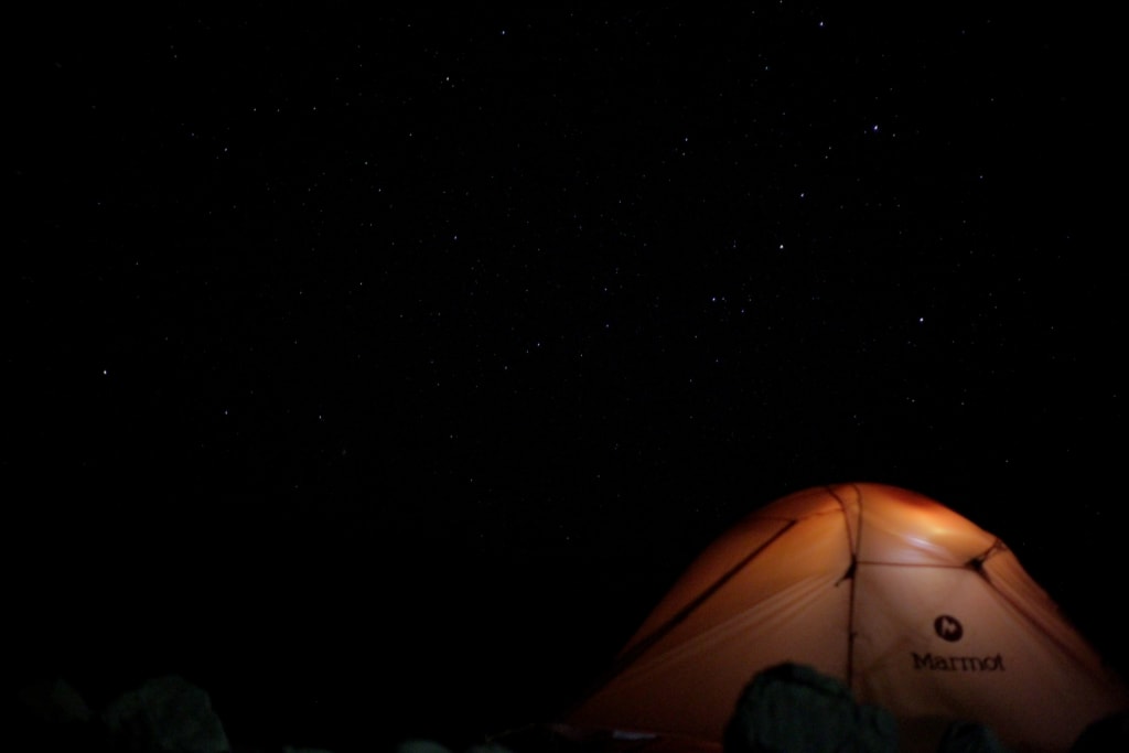
It took a little over 2 hours to cross the distance to our campsite. Perfect timing, we arrived just in time to begin cooking dinner. I set up the tent and sleeping bags as Ian boiled water and poured it into our bags of food. To the southwest, across the river, we watched dark clouds gather, the occasional flash of lightning illuminating the gathering storm from within.
We wanted to have another night without the fly, but the clouds grew darker, spread out further and I opted to be prepared for a wet night and put the rain fly on the tent preemptively. We took our dinners up onto a hill and sat in the dirt, watching the sun set behind the Chisos Mountains.

Back down at the tent, I got out my camera and a couple small tripods, setting up both the camera and my phone to take photos of the stars. We spent a few hours talking, taking pictures and drinking liter after liter of water. The storm across the river blocked the light of the rising moon, keeping the sky over out heads filled with stars, constellations we couldn’t even begin to name. Eventually I turned my camera towards the storm, unsure if I would capture anything, but snapping photos for a little while. After several minutes of that I decided to switch to recording video and let it roll for a few minutes.
After that, we packed everything away and climbed into the tent. It had been one of the longest days since we’d arrived in the park, but was also the least physically demanding so far. Still, we were both exhausted. We would be spending the next day in the Chisos Basin and were excited to see yet another new area of the park.
About the Creator
Keep reading
More stories from Adam Lupiani and writers in Wander and other communities.
Overnight Hiking the Marufo Vega Trail
My alarm went off a little before 6a. A coyote yipped and howled in a pattern that almost matched that of my alarm. Ian and I lay in the tent for another hour after the coyote stopped, worried that the sound of the alarm may have drawn its interest. The day before us was going to be a busy one. Ian dressed and headed up to the car to begin getting breakfast ready. I stayed down at the bottom of the hill and broke down our campsite, packing everything into the appropriate carry sacks and brought it all to the car. We packed our big backpacks while we ate.
By Adam Lupiani2 years ago in Wander
Was I a Model in Japan?
During my time in Nagoya I worked and lived at the strangely famous hostel and café Nagonoya. With its chequered floors and florescent lighting it felt quite dated, but I think that was supposed to be part of the charm. The dorms were always fully booked on weekends with domestic tourists and there was always a buzz in the downstairs café. Camera crews were constantly in and out of the place interviewing the Japanese staff members who worked the café. I think it had something to do with the egg sandwiches. At least that was what was on most of the merchandise, except for that one dishcloth with the owner’s face on it. Was I being employed by a local celebrity?
By Susanna Kiernan5 days ago in Wander
Lafayette Along the Vermillion River
Lafayette stretches along the Vermillion River in southwestern Louisiana. Acadian Village is a privately owned park spanning 32 acres. It was founded in the 1970s to safeguard Acadian heritage. Within its premises, visitors can explore a Cajun village from the 1800s. The village is comprised of eleven structures, out of which seven are genuine 19th-century residences. Guided tours are offered, and the grounds can also be leased for various occasions.
By Rasma Raistersa day ago in Wander
TICK TOCK
11.59. Even though the glass had shattered, Lorna could still see that her watch ticked over. One minute until midnight. Her watch was the only thing she had that she could carry. The only thing to remember her parents by. A birthday present from last year, the year she turned seventeen.
By Elizabeth Butler3 days ago in Fiction


Comments
There are no comments for this story
Be the first to respond and start the conversation.