
5 Places to Visit Near Moab That are NOT in the Parks
Do you want to visit Moab, but want to avoid the crowded national parks? Check these out!

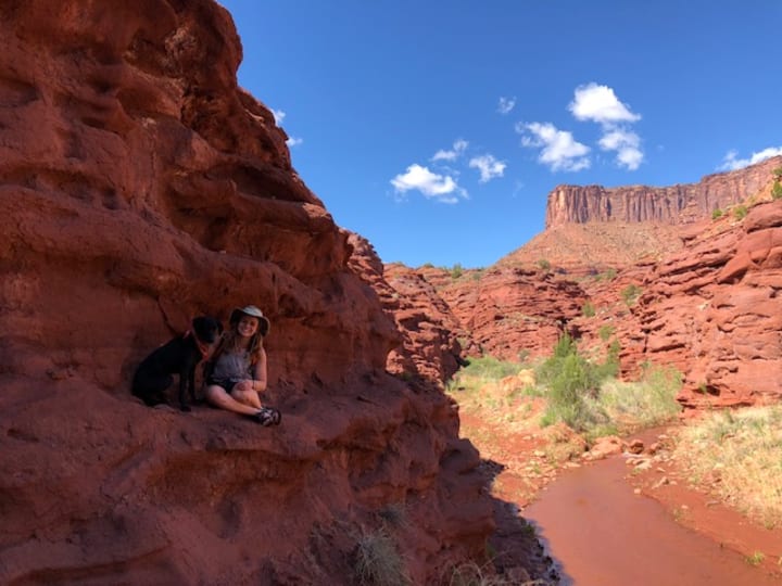
Moab, Utah is one of the most extraordinary places I’ve ever had the pleasure of visiting. It is filled with rich history, lots of great hiking, incredible views, and so many different activities.
When people ask me where I typically hike in Moab, they usually ask “Which parks did you visit?” Utah actually has 5 national parks; Zion, Arches, Bryce Canyon, Canyonlands, and Capitol Reef. Arches National Park and Canyonlands National Park are both in the Moab area, as well as Dead Horse Point State Park.
The first time I visited Moab (March 2017), I visited the 3 parks in the area. They were absolutely beautiful and there were tons of great views! However, these parks were pretty crowded and the hiking trails all required dogs to stay on leash. If your dog is anything like mine, she has to RUN… which isn’t so great for crowded trails on a leash.
Now I’ve been back to the Moab area over 30 times since this first visit.. and I’ve never gone back into any of the parks. I’ve spent weeks hiking, camping, and exploring in areas that not only can my dog run off leash, but they are significantly less crowded. (And just as beautiful!)
I thought it would be fun to share some of my favorite places in the Moab area to visit that aren’t in the state or national parks!
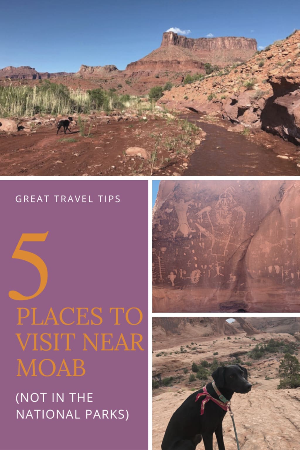
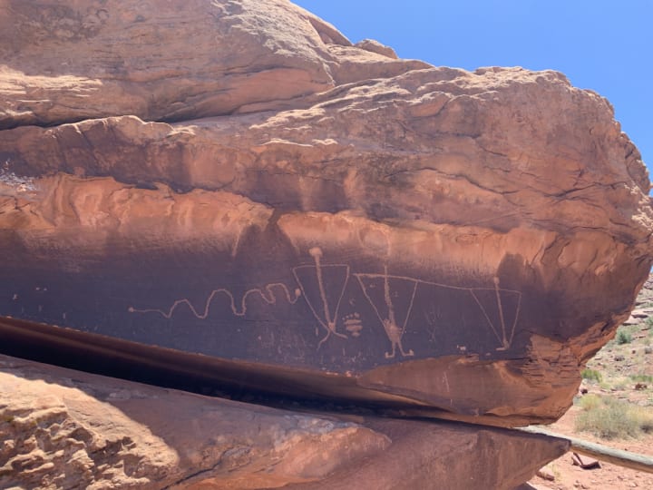
Moonflower Canyon and The Birthing Rock Petroglyphs
There are tons of places to see petroglyphs in Utah, but these are some of my favorites and they don’t require a hike to get to them!
How to get there: From Moab, you will turn onto Kane Creek Blvd, right by the McDonalds. From this road, you will be able to access both of these beautiful rock art panels very easily.
• Moonflower Canyon will be about 3.1 miles down the road, on your left. The petroglyphs will actually be to the right of the parking lot for Moonflower Canyon. They are behind a fence and have a sign!
• There is a campground across the street that you can also park in! Camping here is tent camping only and it is $8 a night.
• The hiking trail into the canyon is pretty short, but great to get out of the Sun!
• The Birthing Rock is one of the first known human recordings of a live birth. Located about 6 miles down Kane Creek Blvd, it is definitely a sight to see. You can see many other drawings on this boulder besides the birthing scene, including other humans, a centipede, and a horse!
• There is one big pull off right in front of the rock, on the right, and a few smaller ones before then. You will have to park your car and walk down a short trail to get to this one!
Just a reminder when visiting any petroglyphs or pictographs, please do NOT touch them, draw on them, or carve into them! The oils from our hands can degrade the rocks and the art, and obviously drawing over them is degrading their history.

This is a really beautiful and scenic hike that is great for all skill levels!
How to get there: To reach this trailhead, you will turn onto Potash Road. Follow along the north side of the Colorado River for about 10 miles. The trailhead will be on your right, across from a campground.
• This trail is about 3 miles round trip.
• It is a pretty moderate hike, and great for all skill levels. The one part I can see giving some people (or dogs) trouble is a ladder that goes up a rock face.
• You will first see Bowtie Arch located high on a cliff above the trail. It is a huge pothole type arch. From here, you have a great view of the Corona Arch!
• The trail will continue to the base of the Corona Arch, where you can get up close to it and climb near it!
• You will turn around here and follow the same route back, so you end up back at the parking lot!
Few reminders for the Corona and Bowtie Arch Trail is to start early! Not only will this avoid a lot of the crowd, but it will avoid some of that heat! Also bring EXTRA water. There are long sections of this hike that are not shaded, so if the sun is beating down…. It’s HOT!

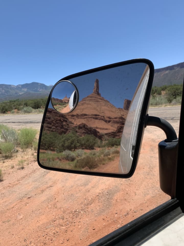
So although I’ve haven’t made the hike all the way to the base of this tower yet, it is still one of my favorite spots in Moab. To me, this tower is one of the most iconic slabs of rock I’ve ever laid my eyes on. Since I started rock climbing it has been on the top of my climbing bucket list.
How to get there: To get to Castleton Tower, you’ll turn on to La Sal Loop Road from HWY 128. You will get beautiful views of the tower for most of this drive.
• You will reach the campground and trailhead about 4.5 miles down La Sal Loop Road, on your left.
• I have never finished the hike, but I have read that it does require a decent amount of scrambling. It is rated as moderate on AllTrails, but the comments say there is a lot of lose gravel you have to be careful with. Many people also pointed out that the trail is not well marked the entire time, so be careful you don’t come off trail!

This is a great trail for any season, but It is especially great in the summer when you need to cool off!
How to get there: From 191 you will turn onto Millcreek Dr. Follow this road until you see Powerhouse Lane, and then turn onto that! The trailhead will be at the end of this road.
• This hike is an out and back that goes anywhere from 1.6- 8 miles, round trip.
• The first section is usually pretty crowded in the summer, since it leads to a beautiful swimming hole.
• Surrounded by ledges, with an incredible waterfall flowing into it, this swimming hole is a great place to hang out all day!
• Once you leave this swimming hole, the hike does become more difficult. It ascends along a stream, which you will have to cross several times. I have done this hike 3 times, at different points in the year, and the stream’s water level is always varying.
• Sometimes you can cross on rocks without getting your feet wet, and sometimes you will be wading through the water.
• This hike has breathtaking views, including huge sandstone walls that tower over you. There are tons of spots on this trail to see rock art. The canyon walls above you are filled with petroglyphs and pictographs.
• About a mile and half in, you will come across a 2nd swimming hole. This one is usually much less crowded!
• Both swimming holes you cannot pass through. Once you hit them, you do have to retract a little bit to get back to the trail to continue onward.
• At about 4 miles in, you will reach the point where Mill Creek and Rill Creek cross. There is more to explore after, but this is always the point I have turned around!

Colorado River Swimming/ Hanging Out
Whether you are on Potash Road (279) or HWY 128, there are lots of spots to swim in and hang out by the Colorado River.
• If you are driving down HWY 128, there are several unmarked pull offs on the side of the road that will give you river access. When I say river access, I was specifically looking for places that had sand for me to relax and room for Bella to run!
• This was kind of a trial and error for me, as some pull off spots did not have a trail that brought you to the river.
• There are several marked areas, such as Sandy Beach and the campgrounds, that offer river spots with easy access. I tried to avoid these when there were people there, which was pretty much all during the busy seasons.
• Driving down Potash Road will have you all along the river as well. I have actually found much fewer beach spot pull offs on this road.
• When I do want to go swimming off of this road, I usually end up going to the campground across from the Corona Arch Trailhead. I only go to this campground during Moab’s slow season, so I am not camping around a lot of people!
• If I don’t plan on camping there (but still want to swim) I will usually park in the Corona Arch Trailhead parking lot, and just walk across the street!


Hopefully this was helpful and that it gave you some new ideas for places to explore! Moab is full of so much to see and experience, and you don’t have to go into the parks to do that!
I completely support paying to get into National and State Parks, as this is what keeps them beautiful and able to be accessed by people everywhere. But you need to make sure you are listening to the rules while you are there, which almost always includes keeping your dogs on a leash. For my dog and I, going to places outside of the parks is what works for us!
About the Creator
Jessica Uhl
Hello! I am a full time traveler, a business owner, a fur baby momma, a writer, a photographer, an environmentally conscious lifestyle advocate, an athlete, and so much more!
Keep reading
More stories from Jessica Uhl and writers in Wander and other communities.
How to Use the Bathroom While Camping the Most Eco-Friendly Way
So where do you go to the bathroom?” is one of the most common questions I hear. Whether I’m telling someone I lived full time in my van, that I only camp in the backcountry outside of established campgrounds, or I sleep in the back of my Subaru quite often… people want to know where I.. ‘go.’
By Jessica Uhl3 years ago in Wander
Was I a Model in Japan?
During my time in Nagoya I worked and lived at the strangely famous hostel and café Nagonoya. With its chequered floors and florescent lighting it felt quite dated, but I think that was supposed to be part of the charm. The dorms were always fully booked on weekends with domestic tourists and there was always a buzz in the downstairs café. Camera crews were constantly in and out of the place interviewing the Japanese staff members who worked the café. I think it had something to do with the egg sandwiches. At least that was what was on most of the merchandise, except for that one dishcloth with the owner’s face on it. Was I being employed by a local celebrity?
By Susanna Kiernan6 days ago in Wander
Adventure Activities in Nepal
Have you ever thought that, apart from trekking and helicopter tours, what other activities can be done? If yes, did you find anything ? If not, then let's discuss what other adventure activities we can do apart from trekking and tours.
By Nepal Trek Adventures & Expedition Pvt. Ltd5 days ago in Wander


Comments
There are no comments for this story
Be the first to respond and start the conversation.