
US government map of Africa mislabels every country at global conference
Controversial map error sparks criticism over geographic accuracy, representation, and the importance of cultural awareness in international events
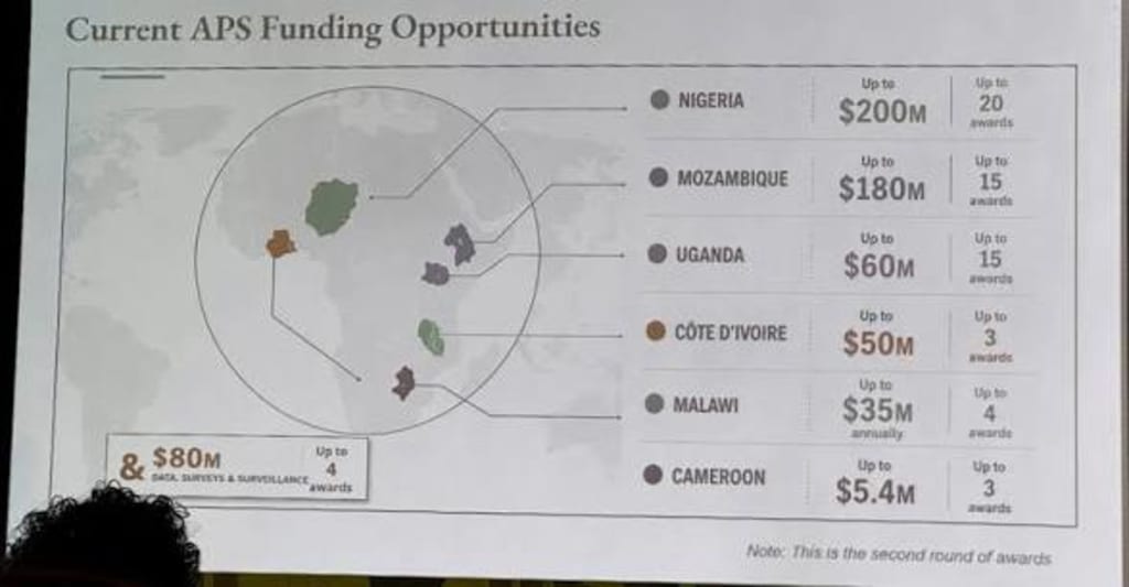
A map displayed by the US government at an international conference has attracted widespread attention after viewers noticed that every country in Africa was incorrectly labelled. The mistake has sparked criticism from diplomats, researchers, and members of the public, who questioned how such a significant geographic error appeared in an official presentation.
Maps are powerful tools used by governments, organisations, and institutions to communicate information about countries, regions, and global issues. Because of this, experts say accuracy is essential, particularly during international conferences where representatives from different nations are present.
The incorrect map reportedly showed African countries with inaccurate names or labels, creating confusion among attendees. The error quickly gained attention as images of the map circulated online, leading to discussions about the importance of careful review processes for official materials.
Africa is made up of 54 internationally recognised countries, each with its own history, culture, political system, and identity. Experts say that incorrectly representing these nations can appear disrespectful and may contribute to misunderstandings about the continent.
Officials and organisers involved in international events often rely on maps to support discussions about trade, climate change, security, development, and diplomacy. A mistake involving the entire continent can therefore affect the credibility of the presentation and raise questions about preparation.
Critics argued that the error reflected a lack of attention to detail and highlighted the need for stronger quality checks before government materials are presented publicly. They said official documents and visual aids should be carefully reviewed by specialists, especially when they involve foreign countries and international relations.
Supporters of improving geographic education say the incident demonstrates the importance of understanding global geography. Africa plays a major role in world affairs, including economic growth, natural resources, technology, environmental issues, and international cooperation.
The continent has experienced significant economic and social changes in recent decades. Several African nations have become important markets for investment, technology development, and international partnerships. Accurate representation of these countries is considered essential for meaningful engagement.
The incident also renewed broader conversations about how Africa is portrayed in international media and political discussions. Some experts argue that outdated or inaccurate representations can influence public understanding and reinforce incorrect assumptions about the continent.
African leaders and organisations have increasingly called for greater recognition of the continent’s diversity and economic potential. They argue that Africa should not be viewed only through challenges but also through opportunities, innovation, and development.
International conferences bring together officials from different regions to discuss shared challenges. In such settings, cultural awareness and respect are considered important parts of successful diplomacy. Mistakes involving national identities or geography can create unnecessary distractions from important discussions.
Government agencies often use professional cartographers, geographic databases, and review teams to prepare maps. However, errors can still occur due to technical problems, outdated information, or failures in the approval process.
Experts say the incident provides an opportunity to improve standards for official communications. They recommend stronger verification procedures, including reviews by geographic specialists and representatives familiar with the regions being shown.
The controversy also highlights the growing influence of digital media. In the past, a mistake in a presentation might have received limited attention. Today, images and videos can spread globally within minutes, placing greater pressure on organisations to ensure accuracy.
For many observers, the issue is not only about a map but also about recognition and respect. Countries represented incorrectly on an official platform may view the mistake as a sign that their identities and histories were not given enough consideration.
The United States maintains diplomatic and economic relationships with many African countries, cooperating on issues such as trade, security, health, and climate change. Maintaining accurate and respectful communication is considered important for strengthening those partnerships.
While officials may describe the map mistake as an error rather than a deliberate action, the reaction shows why details matter in international affairs. A single inaccurate image can influence public perception and create discussions about representation.
As global cooperation becomes increasingly important, experts say governments and institutions must ensure that their information reflects the realities of the countries they engage with. Accurate maps are not only technical tools; they are also symbols of recognition and understanding.
The incident serves as a reminder that even simple mistakes in official presentations can have wider consequences. In a world connected by diplomacy, trade, and technology, accuracy and respect remain essential elements of international communication.
About the Creator
Enjoyed the story? Support the Creator.
Subscribe for free to receive all their stories in your feed.
Comments
There are no comments for this story
Be the first to respond and start the conversation.