
Sino — Indian Border Dispute: How India and China are stuck in a deadlock?
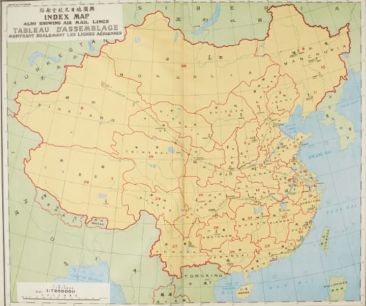
At different time intervals, several lines were proposed by the British as a border between India and China

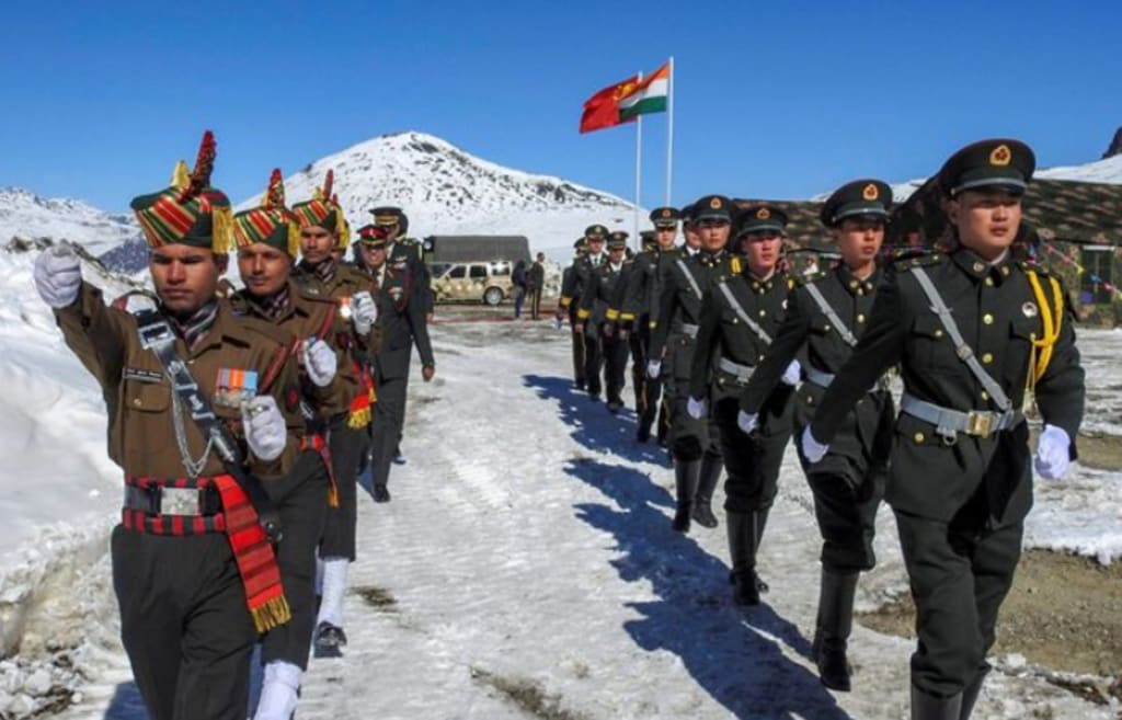
The current levels of tension at different locations on the disputed India-China border, because of Chinese soldiers moving into the Indian territory across the Line of Actual Control (a demarcation line which separates the Indian controlled territory from the Chinese controlled territory) has raised questions about the motive of Chinese.
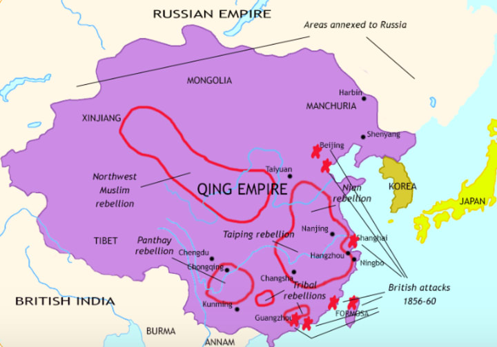
The boundary issue that India and China are facing is a contradiction between the Chinese empire and the present-day India, which was formed and demarcated by British colonialists. During the early 19th century, the Russian Empire was longing for a colonial empire and a warm water port (A ‘warm water port’ is a port where the water does not freeze in winter. Much of the ports in the Russian Empire become frozen during winter season) and thus, threatened the British.
The British thought of responding to the Russian threat and introduced a forward defensive line in the northern region, to halt the Russian thrust well before Hindustan. This made Afghanistan and Tibet into buffer states (A ‘Buffer state’ is an area lying between the borders of two powerful empires). At different time intervals, several such lines were proposed by the British and meanwhile, in the mid 19th century, China lost a great tract of territory to the Russia Empire.
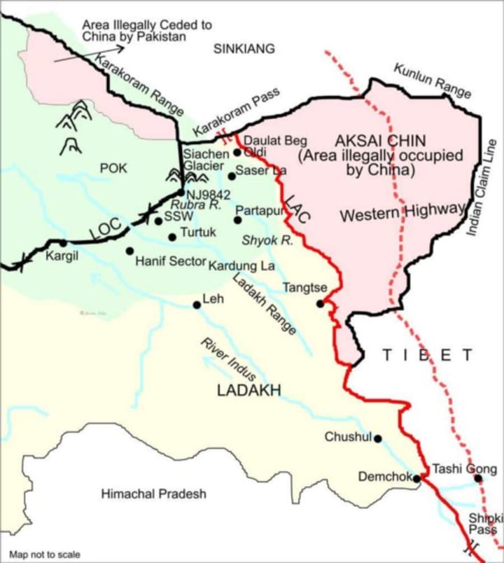
After that China decided not to negotiate from a weak position. The most notable line was the one in 1865, when William H. Johnson, a civil servant with the Survey of India, proposed the “Johnson Line”. This line was to link Demchok in the South with the 18000 feet high Karakoram pass in the North, but it took a circuitous route beyond the Kuen Lun Mountains and thus included the barren and cold Aksai Chin desert.
During this period, the Dungan revolt (a religious and ethnic war fought in western China) was taking place and this was the time when most of Xinjiang was not controlled by China, due to these reasons the line was never presented to the Chinese. However, Johnson presented this line to the Maharaja of Kashmir, who then accepted it under his territory.
The Ardagh–Johnson Line was proposed as a boundary of Kashmir to the British Indian government by Major General John Ardagh in 1897. The Line was one of the three boundary lines considered by the British Indian government, the other two were the Mccartney–MacDonald Line and a line along with the Karakoram range. The Ardagh–Johnson Line was represented as a forward defence boundary against the growing Russian empire.
Representatives from Britain, China and Tibet attended a conference in Simla in 1913 regarding the borders between Asian nations. The agreement was initiated by the representatives at first, but later it was objected by China. The British Indian government, who had drawn up the proposal, decided to bypass the Chinese and settle the border bilaterally.
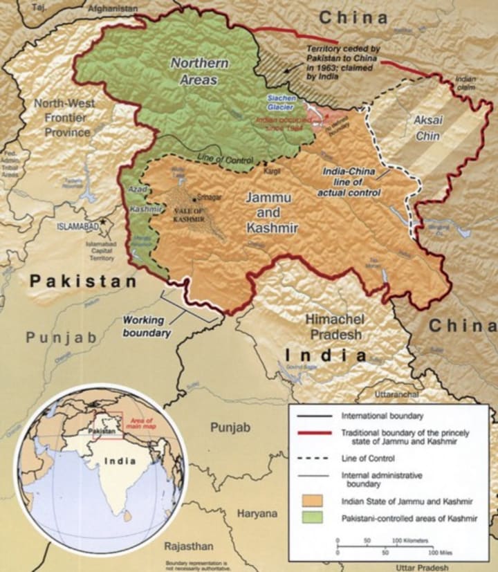
From 1917 to 1933, the “Postal Atlas of China”, published by the Government of China also showed the boundary in Aksai Chin as per the Ardagh–Johnson line, which runs along the Kunlun mountains. After attaining independence in 1947, the Indian government fixed its official boundary in the western side which included the Aksai Chin, in a manner that resembled the Ardagh–Johnson Line.
A view was held by the Indian government that the Himalayas was the ancient boundary of the subcontinent and thought it should also be the modern boundary of the subcontinent. But the Chinese government thought that the disputed area in the Himalayas has been geographically and culturally a part of Tibet from ancient times. To have control over the region and to expand their territory, the Chinese invaded Tibet in 1950. Tibet had de facto been its own country before 1951.
In 1951, the Tibetans signed a seventeen-point agreement reaffirming China’s sovereignty over Tibet and providing an autonomous administration led by Dalai Lama. In some Western opinions, the incorporation of Tibet into China is viewed as an annexation. In 1956, China constructed a road through Aksai Chin, connecting Xinjiang and Tibet, which ran south of the Johnson Line in some places. The Indian government didn’t know the existence of the road until 1957 and confirmed it finally when the road was shown in the Chinese maps. The road construction was considered as one of the triggers for the Sino-Indian War of 1962.
In a letter dated on7th November 1959, the Chinese Prime Minister Zhou Enlai told the Indian Prime Minister Jawaharlal Nehru that the Line of Actual Control (LAC) consisted of the McMahon Line in the east and the line up to which each side could exercise actual control in the west. At the time of the Sino-Indian War in 1962, Nehru refused to recognise the line of control: “There is no sense or meaning in the Chinese offer to withdraw twenty kilometres from what they call the line of actual control”. The Chinese PM responded on the same day that “LAC was still the line of actual control as existed between the Indian and the Chinese sides”.
At the end of 1981, officials from both countries started to hold yearly talks on the border issue. Logistics improved on the Indian side, the Army of India sought to reinforce and strengthen forward areas in Arunachal Pradesh in the early stages of the 1980s. In summer 1984, India established an observation post on the bank of Sumdorong Chu, which is located in the Indian state of Arunachal Pradesh.
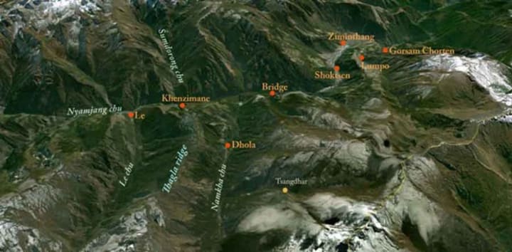
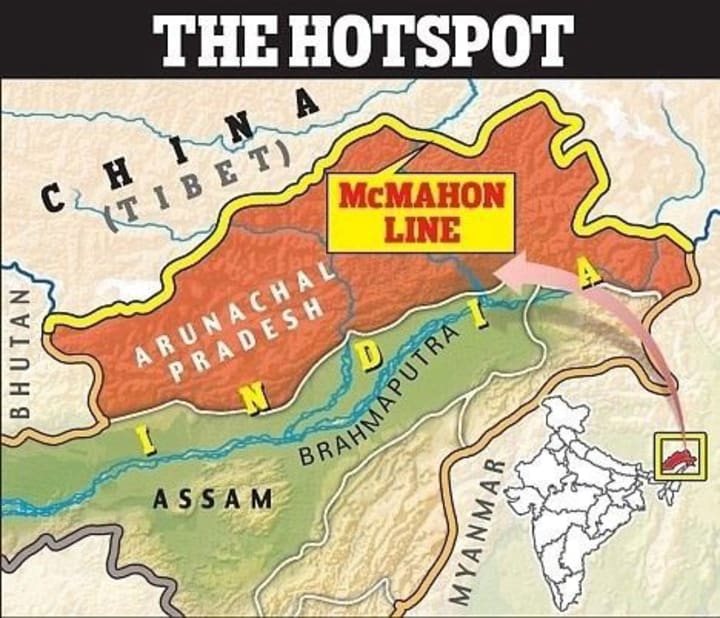
There were reports in the Indian media regarding Chinese incursions into the Sumdorong Chu river valley in Arunachal Pradesh in July 1986. In the following month, a brigade of the Indian Army 5 Mountain Division (The insignia of 5 Mountain Division is a ball of fire, a divine weapon known as a chakra, lifted from Hindu mythology) was airlifted to Zimithang, which is a helipad very close to the Sumdorong Chu river valley. India established the so-called Arunachal Pradesh in its Chinese-claimed territories in February 1987. China said it never recognizes the illegal McMahon Line and Arunachal Pradesh under the Indian territory.
After these events, India converted Arunachal Pradesh from union territory to a state after which tensions between China and India escalated. Both sides reinforced their capabilities in the area, but neither ruled out further negotiations of the dispute. Since 1981, when the first round of border talks was held, officials from India and China have met several times to find a solution to the issue. At the beginning of the 21st century, both sides agreed not to let the border dispute affect bilateral engagements.
India is now witnessing its worst-ever border tensions since the war against Pakistan in 1999 (Kargil War). The Chinese army has brought forward nearly 5000 troops along the Line of Actual Control in the region of eastern Ladakh. Both India and China have not fired even a single bullet since 1975, but small-scale clashes have escalated throughout. The Chinese and Indian troops have only thrown rocks and tried to shout each other down along the disputed border so far.
Although the Sino-Indian border dispute might settle with a general framework, no side will move forward with an agreement. This is because no one will trust the other and also their domestic politics will prevent both the sides from making any concessions.
About the Creator
Keep reading
More stories from Siddharth Shankar V and writers in The Swamp and other communities.
India — China: Is War Possible in the Future?
The armies of the world’s two most populous nations are locked in a tense face-off high in the Himalayas, which has the potential to escalate as they seek to further their strategic goals. The Indian Army and the Chinese military are moving heavy equipment and weaponry including artillery and combat vehicles to their rear bases close to the disputed areas in eastern Ladakh.
By Siddharth Shankar V4 years ago in The Swamp
The Elasticity of Opinions
Debates and disagreements on all things political, religious, economic, racial and social are very much a part of human life. As people, we are all so vastly different with unique lived experience, upbringings, viewpoints, and biases. If we operate in a world where we express ourselves and our thoughts and beliefs honestly with others, especially others who are in fact so different from us, debate is only natural. I have learned so, so much from talking about important subjects from debating with other people.
By angela hepworth2 days ago in The Swamp
Who You Might Be Based on Who You Sympathize With: PALESTINE, UKRAINE, RUSSIA, ISRAEL
UKRAINE & ISRAEL: The Liberal You might prefer relatively liberal societies that have a reasonable amount of social norms and expectations, and a certain degree of censorship and bad reactions to (some) protests. You may be center-left or center-right, possibly a neoliberal (or possibly, but less likely, a Trotskyite or nationalist) of some sort. Also includes neoconservatives, and some other (pro-establishment) "elitists" from almost every part of the political compass. These people are mostly afraid of something really "different" (in their government). They are afraid of change. They are probably also afraid of too much chaos and extremes. A lot of them might just want to live their lives (or think that), and would like more people to follow their "majority", "normal" stance on this issue. In addition, you might also have some ancestry or heritage that is Jewish or Ukrainian.
By ANTICHRIST SUPERSTARabout 15 hours ago in The Swamp


Comments
There are no comments for this story
Be the first to respond and start the conversation.