
How to Read a Street Like a GeoGuessr Pro: The Clues Hiding in Plain Sight
Five everyday details reveal where a GeoGuessr photo was taken: driving side, plates, road lines, script, and the survey car. Read a place, don't memorize it.

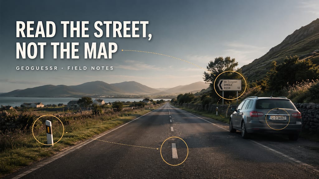
Every street is quietly labeled. The side the cars keep to, the color of the plates, the paint on the asphalt, the shape of the letters on a shop sign: each one is a small confession about where you are. Most people walk past them. GeoGuessr players learn to read them.
That, more than anything, separates a wild guess from a confident one. You are not trying to recognize a famous landmark. You are reading a place the way you would read a page, letting a handful of ordinary details point you to the continent, then the country, then the region.
Here is the visual language I learned to read, starting with the clues that do the most work.
Key takeaways
- Getting better at GeoGuessr is a reading skill, not a memory test.
- Five everyday details carry most of the meaning: driving side, license plates, road markings, script, and the survey car.
- Roughly a third of the world drives on the left, so that single detail rules out about half the map.
- The aim is elimination: let each clue delete part of the world until one region is left.
What does it mean to "read" a street?
GeoGuessr drops you into a random Google Street View location, and Google's cameras have covered more than 100 countries and over 10 million miles of road. The odds of recognizing your exact spot are tiny. So stronger players stop trying to recognize and start trying to eliminate. Every detail you notice removes a slice of the planet. Read enough of them and the answer narrows itself.
Think of the five clues below as the alphabet of that language.
Which way does the traffic flow?
This is worth checking first, before you move the camera at all, because it splits the world almost down the middle. According to World Standards, around 35% of the world's population drives on the left: the UK, Japan, Australia, India, and much of southern Africa among them. Most of the rest drives on the right.
One look at the oncoming traffic, or at the lane the camera car sits in, and half the map is gone.
What story does the license plate tell?
You are not reading the numbers. You are reading the shape and the color. A blue band down the left edge marks a European plate. Yellow rear plates lean toward the Netherlands, Luxembourg, or the United Kingdom. Long and narrow feels European; short and square feels North American.
Even a smudged plate at the edge of the frame is often enough to settle a continent.
What is painted on the road?
Road paint is a national habit, and habits stay consistent. Yellow center lines run through much of the Americas and Japan. White center lines dominate most of Europe. And the absence of any markings, on bare or patchy tarmac, quietly points toward parts of Eastern Europe, Central Asia, or rural Africa.
It took me an embarrassing number of rounds to start looking down at the road instead of staring at the horizon.
What alphabet is on the signs?
If there is text anywhere on screen, the writing system alone can hand you a region in a second. Cyrillic, Arabic, Thai, Japanese, Korean, and Greek each collapse the map immediately. Within the Latin alphabet, the accent marks do the finer work: å, ä, and ö for the Nordic countries; ą, ę, and ł for Polish; ț and ș for Romanian.
You do not need to understand the words. You only need to notice the letters.
Who took the photo?
The camera itself is a clue. The rig Google used changed from country to country and year to year, so the survey car leaves a fingerprint: a particular color cast in the blur, a snorkel or antenna rising from the hood, roof racks, or a reflection caught in a window. Kenya's unusually tall snorkel is the classic example. It will not name a city, but it can confirm a country you already suspect.
Why do these clues beat memorizing the map?
Because they travel. A landmark only helps if you happen to land beside it, but driving side, road paint, and script appear in nearly every location on earth. Memory rewards the rare lucky round; reading rewards every round.
Somewhere along the way I started keeping notes on every tell I could find, and they eventually grew into a full clue-by-clue field guide that I wrote up in one place, with the bollard meta, climate and vegetation cues, and a short routine for working through a panorama under time pressure. The five clues above are simply the ones I reach for first.
How do you practice GeoGuessr clues?
The same way you learn any language: repetition with feedback. Play a round, commit to a guess, and then, before you move on, look at what you missed and name the clue that would have caught it. Was it the plate? The script? The paint? A free GeoGuessr alternative with unlimited rounds is plenty for this, since you do not need a paid account to drill the basics. The review step, not the guessing, is where the skill actually forms.
FAQ
Can you really tell countries apart from a single photo?
Often, yes. You rarely pin the exact place, but the combination of driving side, script, and road markings usually narrows it to one country or a small cluster of them.
Do professional players memorize the whole world?
At the very top, some memorization helps. For everyone below that level, learning to read repeatable clues improves your guesses far faster than rote memory.
What is the easiest clue to start with?
Driving side. It is instant, it appears in almost every round, and it removes roughly half the map before you have done anything else.
Sources: World Standards (driving on the left or right); Google Street View coverage figures.
About the Creator
John
John explores the best free apps, AI tools, and creative platforms so you don’t have to. He breaks down what works. If you love discovering powerful tools and smart comparisons, you’re in the right place.
Enjoyed the story? Support the Creator.
Subscribe for free to receive all their stories in your feed.
Comments