
The Yuan Dynasty Built Provinces That Made No Sense. Here’s What They Reveal About Empire.
How one branch secretariat governed from Sanya to Wuhan, why Gui Prefecture became an enclave, and what a 2,500-kilometer province tells us about power, taxes, and bureaucratic accidents.
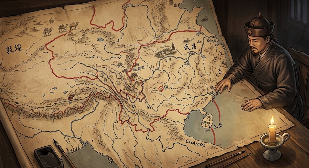
The Yuan Branch Secretariats: puzzle provinces, enclaves, and the limits of empire
The Yuan dynasty called them xing zhongshu sheng, branch secretariats of the Central Secretariat. The name matters. A province in the modern sense is a unit of local government. A Yuan branch secretariat was an outpost of the central court. It could be moved, merged, stretched, or abolished. It held military, fiscal, and civil authority. Its officials signed documents together, answered to the center, and served as conduits for revenue moving north. The map that resulted looks like a record of campaigns, tax routes, and temporary compromises.
Some Yuan provinces look absurd for this reason. Henan Jiangbei was nicknamed the rebel province. Huguang ran from north of the Yangtze to Hainan, with its administrative seat at Wuchang, near the northern edge. Jinghu-Zhancheng tried to tie Huguang to Champa. Gui Prefecture became an enclave because its seat was on the south bank of the Yangtze. Shaanxi-Sichuan stretched from Dunhuang to Chengdu and beyond. These were the working map of an empire that used branch secretariats as tools.
Henan Jiangbei: the puzzle province
Henan Jiangbei Branch Secretariat was established in Zhiyuan 28, or 1291. The court gave a formal reason: Henan and Jiangbei were key crossroads. The territory was assembled from three sources. From the Central Secretariat came the Jiangbei Henan Circuit. From the Jianghuai Branch Secretariat came the Jiangbei Huaidong and Huaixi Jiangbei Circuits. From Huguang came the Shannan Jiangbei Circuit. These four surveillance commission areas were pulled out and fitted together into one province.
The province looked like a puzzle. It had a certain geographic shape. It ran from the Yellow River in the north to the Yangtze in the south, and it touched the sea in the east. Its latitudes sat roughly between thirty and thirty-five degrees north. It was longer east to west than north to south, but it was not a freak of geometry. Its reputation came from people, not from latitude.
In the late Yuan, this region produced uprisings in clusters. Liu Futong rose in Yingzhou. The Sesame Li rose in Xuzhou. Guo Zixing rose in Haozhou. Zhu Yuanzhang began from Haozhou. Zhang Shicheng rose at Gaoyou. The court called the area a key crossroads, and it was. The Yellow River, the Huai River, and the Grand Canal met there. River labor gangs, salt fields, grain transport, military farms, and post stations crowded together. Floods ruined fields. Famine pushed people into bands. White Lotus networks gave them organization. The nickname “rebel province” describes a social explosion, not a geographic curse.
Huguang: Wuchang to Sanya
Huguang was larger and stranger. It reached north of the Yangtze and south to Hainan. Its administrative center was Wuchang, which is modern Wuhan. Wuchang sits at the northern end of the province. Jiyang Jun, which is modern Sanya, sat at the southern end. Both belonged to Huguang. The branch secretariat officials lived in Wuchang.
The straight-line distance from Sanya to Wuhan is about 1,450 kilometers. Today, a driver on expressways, not counting the ferry across the Qiongzhou Strait, needs about nineteen hours. In the Yuan, a document, a tax shipment, or a military order had to cross the Yangtze, the Dongting Lake region, the Xiang and Gan river systems, the Nanling mountains, the Pearl River basin, and the Qiongzhou Strait. The officials who governed Hainan sat in Wuchang.
The span was not fixed. In Zhiyuan 17, or 1280, Huguang reached from Junzhou in the north to Jiyang Jun in the south. Junzhou lay near modern Danjiangkou in Hubei. Jiyang Jun lay at Sanya. The straight-line distance was nearly 1,700 kilometers. A single branch secretariat ran from the edge of the Qinling mountains to the island of Hainan.
Huguang also had two units north of the Yangtze: Hanyang Prefecture and Gui Prefecture. Hanyang sat on the north bank. It was first assigned to Henan Jiangbei. Five months later, Kublai issued a special edict returning it to Huguang. Gui Prefecture stayed with Huguang. Its seat was on the south bank. That accident created an enclave and a boundary tangle in the Three Gorges.
Jinghu-Zhancheng: the stretch to Champa
If Huguang from the Qinling edge to Hainan was already extreme, the Jinghu-Zhancheng Branch Secretariat went further. In the early 1280s, during the Yuan campaigns against Champa, the court combined Jinghu, or Huguang, with the Champa Branch Secretariat. The court called the combined unit the Jinghu-Zhancheng Branch Secretariat. On paper, the same administrative structure that governed Wuchang and Sanya now reached into central Vietnam.
Champa lay in what is now central Vietnam. It ran roughly from the Hoanh Son region south to Binh Thuan. The Mekong delta was not Champa. That delta was mainly Khmer territory. So the Jinghu-Zhancheng Branch Secretariat did not govern to the Mekong mouth. It tried to tie a Chinese inland province to a distant campaign zone in central Vietnam.
This was a military and logistical arrangement. It existed briefly. Its control was thin. Officials sat in Wuchang and tried to project power into Champa. The distance was a matter of military reach. The branch secretariat became a chain linking the Yangtze middle reaches to a war in Southeast Asia.
Gui Prefecture: the enclave made by a wording
Huguang’s enclave in the Three Gorges is a case study in literal compliance. In Zhiyuan 22, or 1285, the court ordered that the tax revenues of the “cities north of the Yangtze” in Huguang be transferred to the Central Secretariat. The phrase “north of the Yangtze” looked simple. It was not.
Gui Prefecture was one of the two Huguang units involved. Its seat was at Jiuzhouhe, on the south bank of the Yangtze. Today, that site is submerged in the Three Gorges Reservoir. In the Yuan, it was the seat of Gui Prefecture. Because the seat was on the south bank, Gui Prefecture did not count as a “city north of the Yangtze.” It stayed in Huguang.
Xiazhou Circuit and Jingnan Prefecture had seats on the north bank. They were transferred. Hanyang Prefecture was on the north bank. It was first assigned to Henan Jiangbei. Five months later, Kublai ordered it back to Huguang. Gui Prefecture remained with Huguang. So Huguang ended up with an enclave north of the Yangtze, created by the wording of an order and the location of a prefectural seat.
Some scholars have read deep designs into this. The record does not support that. The court said “north of the Yangtze.” Officials applied the phrase to seats. A seat on the south bank did not qualify. The enclave was a bureaucratic accident.
Shaanxi-Sichuan: a province 2,500 kilometers long
In Zhiyuan 17, or 1280, the Shaanxi-Sichuan Branch Secretariat was one of the most extreme shapes on the Yuan map. It ran from Dunhuang in the northwest, southeast to Xi’an, southwest to Chengdu, and south to the Daliangshan region. Using Ganzhou, Lanzhou, and Chengdu as nodes, the span from the western boundary of Shazhou to the southern boundary of Huichuan exceeded 2,500 kilometers. That is comparable to the span of the Sakha Republic in Russia, the largest first-level administrative unit in the world.
This was a conquest-era military province. The Yuan had not yet stabilized its rule over the former Jin and Song borderlands. Shaanxi, Sichuan, and eastern Gansu were tied together for war, revenue, and supply. Below the branch secretariat were pacification commissions, native offices, and loose-rein arrangements. The map showed a huge province. The actual reach of officials was thinner than the lines suggested. Later, the court split Sichuan and Shaanxi into separate branch secretariats. The map became less dramatic.
Why the map looked like this
The Yuan branch secretariat was an outpost of the Central Secretariat. It did not have a stable territorial interest. It held military and civil authority. Its officials handled grain, salt, taxes, transport, farms, and garrisons. But they did not act alone. Multiple officials signed together. The court sent darughachi, keshig men, and rotating appointees. The center watched the branch secretariats closely.
The court also treated the Han provinces as transit stations for wealth. Grain, silk, salt revenue, and commercial taxes from the south moved through the branch secretariats toward Dadu, Karakorum, and the northern garrisons. Boundaries followed revenue routes, military supply lines, and the policy of using the north to control the south. Li Zhian’s point is useful: the distortions of Yuan branch secretariats should be sought in the empire’s treatment of the Han provinces as wealth transit stations and in its political-military policy of using the north to control the south.
That policy explains why administrative seats often sat at the northern edge of a province. Wuchang governed Huguang from the north. It was easier to link Wuchang to the center than to link Sanya to the center. It also explains why boundaries cut across natural regions. A province could hold a piece of the Yangtze north bank and a piece of Hainan because the court cared about revenue and control, not about the coherence of local society.
Crude, temporary, and consequential
The Yuan branch secretariat system had poor self-consistency. It was a reaction to the fragmented administrative map of the Song and Jin. The Song and Jin had too many layers and too many small units. The Yuan swung to the other extreme. It created huge, military-fiscal regions that could move resources and armies. The swing was crude. It produced provinces that were hard to govern as civil units.
The system was also a trial. Qin used commanderies and counties. It collapsed quickly. Han built on the model. Sui abolished the stacked commandery-county system and used a two-level structure. Sui was short-lived. Tang inherited the framework. The Yuan branch secretariats were crude and unstable. After the late Yuan adjustments and early Ming changes, they became the basis of the Ming-Qing provincial system. The modern province has a Yuan ancestor.
That inheritance does not make every Yuan boundary wise. It means the Yuan experiment, for all its distortions, left a working skeleton. The Ming and Qing trimmed it, clarified it, and made it governable. The Yuan had used branch secretariats as tools of conquest and extraction. Later dynasties turned them into ordinary provincial government.
The map as a record of power
A Yuan province could run from Sanya to Wuchang. It could run from Dunhuang to Chengdu. It could sit in Wuchang and claim to govern Champa. It could leave Gui Prefecture in Huguang because the prefectural seat was on the south bank of the Yangtze. These boundaries did not follow language, economy, or terrain. They followed power, revenue, military supply, and the wording of court orders.
The map looks strange today. At the time, it was the working map of an empire. Officials moved grain and soldiers through it. Clerks copied orders across it. Magistrates tried to collect taxes within it. The absurdity was practical. The distortions shaped tax collection and military movement. The system was a set of experiments held together by the court.
The Yuan branch secretariats were a costly trial. They stretched administrative geography to its limits, then broke. The pieces were reassembled by later dynasties. The provincial map of later China still carries traces of that trial. The old seats at Wuchang and Jiuzhouhe are gone or changed. The lines on the map remain.
About the Creator
Jin
Writer of reamstories
https://reamstories.com/jin
Enjoyed the story? Support the Creator.
Subscribe for free to receive all their stories in your feed. You could also become a paid subscriber, letting them know you appreciate their work.
Comments
There are no comments for this story
Be the first to respond and start the conversation.