
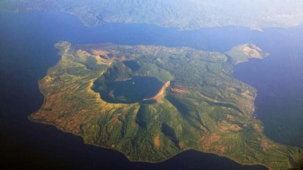
Did you know the mystery of Taal volcano? Where is it located? It is one of the Philippines’s deadliest volcanoes. It is the country’s second most active volcano with 43 recorded historical eruptions, between 1572 and January 20, 2020, all of which were concentrated on Volcano Island, near the middle of Taal Lake. This huge and magnificent caldera was formed by prehistoric eruptions between 140,000 and 5,380 BP. It also holds the record being the world’s smallest active volcano. Often described as “An island in a lake, on an island, within a lake, on an island” Primarily because the presence of an island (more of an islet, known as Vulcan Point) in the Main Crater’s Lake located on the Volcano Island, which sits in the middle of a larger lake, called Taal Lake, in a bigger Island, that of Luzon. Specifically in the province of Batangas about 50 kilometers (31 mi) south of Manila. The caldera was formed by prehistoric eruptions between 140,000 and 5,380 BP.
The crater lake on the volcano Island, is a weakened form of sulfuric acid with high concentration of Boron, Magnesium, Aluminum and Sodium in salt form. Its average depth measures 25 meters. Swimming is still allowed in the Lake.
This island covers an area of about 23 square kilometer and consists of 47 different volcanic craters. It is the second most active volcanoes in the Philippines. Second to Mayon Volcano, likewise in Luzon, known for its impeccably coned shape feature. These volcanoes are both part of the Pacific Ring of Fire. Permanent settlement in the island is for all time disallowed, prohibited by the authorities and the government. Despite these warnings, admonitions, and laws, poor families have settled on the island putting their lives in danger. Earning a living through tourism as tour guides, fishing, and cultivating crops from it’s rich volcanic soil. . Its unexplained shape and location on an island within a lake makes it an exceptional geologic wonder exciting a large number of geologists, sightseers and tourists both local and foreign.
Taal Volcano has had several violent eruptions in the past, causing deaths on the island and the populated areas surrounding the lake, with an overall death toll of about 6,000. The most recent eruption was in January 20, 2020. Because of its proximity to populated areas and its eruptive history, the volcano was designated a “Decade Volcano”, worthy of close study to prevent future natural disasters.
Any volcano may be designated a Decade Volcano if it had more than one volcanic eruption and hazard in recent geological time frame; is located in a thickly populated area as eruptions of any of the Decade Volcanoes may compromise tens to hundreds of thousands of people; it is strategically and physically accessible for study and research; and there is local support for the work. There are 16 volcanoes in the world, designated by the International Association of Volcanology and Chemistry of the Earth's Interior (IAVCEI), as being deserving of particular study in light of their history of huge, full blown, destructive eruptions and it’s proximity to thickly populated areas. They are named Decade Volcanoes on the grounds that the undertaking was started during the 1990s as a component of the Unified Nations’s “International Decade for Natural Disaster Reduction”.
In 1911, a devastating eruption claimed over a thousand lives. The deposits of the eruption drastically changed the floor of the main crater lake and created Vulcan Point.
As part of a chain of volcanoes along the island of Luzon which were shaped by two tectonic plates colliding for over a million years ago. Since the formation of this large caldera (Taal Lake), subsequent eruptions created another volcanic island within Taal Lake known as volcano island. A total of 43 eruptions have been recorded at Taal, up until this point since the sixteenth century. Mostly small eruptions and confined to the Volcano Island. Be that as it may, occasional violent activity has affected and impacted the entire region with the death toll estimated at over 6,000 people as a result of its violent eruptive history and it’s proximity to populated areas.
Taal now is an enormous freshwater lake, but it was once high in salinity, a seawater lake. The 18th century major eruptions that lasted for almost a year, sealed Taal Lake from the ocean. The once wide channel, as seen from those 16th and 17th century maps, is now a mere river, The Pansipit river. Of the 30 rivers that fed the lake, it is the only outlet that drains the water from the lake out into Balayan Bay in South China Sea. Eventually, sharks, sea snakes and other salt water species has somehow were able to adapt to its new environment. The January 20, 2020 eruptions, resulted in a narrower Pansipit River as land bulges were observed along its path.
For a really long time Taal Lake has been used, utilized and abused by local communities to its detriment. Most of the maltreatment of the lake has been in the form of overfishing and exploitation with the deployment of fish cages for aquaculture profit. With the ever consistently expanding and increasing scarring of the mountain sides and valleys for housing projects, the removal of the forests and the pollution of the rivers and streams that feed the Taal Lake, are now the lake’s greatest enemies. The Pansipit River is the sole drainage outlet of the Lake. The river now has a narrower entrance at Lake Taal and stretches nine kilometers before emptying into Balayan Bay. At one time more than 80 different species of fishes were found to inhabit the river either as a migratory channel or as a permanent residence. This once included Taal Lake’s now extinct population of bull sharks. Fresh water Hydrophis semperis, one of the world’s two fresh water sea snakes can still also be found in the lake. These sea snakes are far more common in Taal Lake than their cousins in the sea but their population is fast decreasing in recent years.
The development and construction of fish cages and fish pens in the lake and close to the mouth of Pansipit River has quite some time been an issue and a problem for the river’s natural ecology. Fish cages and fish pens oftentimes spanning the width of the entire river; physically blocking the natural migratory paths of fish species that move between the lake and the sea. Throughout the years, various measures have been endeavored to control the developing number of unlawful fish confines in the lake and along Pansipit River. None has been effective enough to put a stop to these practices.
About the Creator
Uncanny Manny
Born and raised in Manila. Now retired. Enjoying life to the fullest by reading and writing.
Enjoyed the story? Support the Creator.
Subscribe for free to receive all their stories in your feed.
Comments
There are no comments for this story
Be the first to respond and start the conversation.