
European Series - The Battle of Wenquan Pass in the "Hippo War"
The Battle of Wenquan Pass in the "Hippo War"

Abandoning the Tenby Valley means that the Attica Peninsula has become a plate that the Greeks must defend. Of course, the Spartans and their Peloponnesian allies would have preferred to focus their defenses on the Isthmus of Corinth. Otherwise, they will not send the regiments withdrawn from the Tenby Valley to the Isthmus of Corinth. However, the Athenians would definitely not want to do so. In this kind of relationship, no one can only care about their own interests.
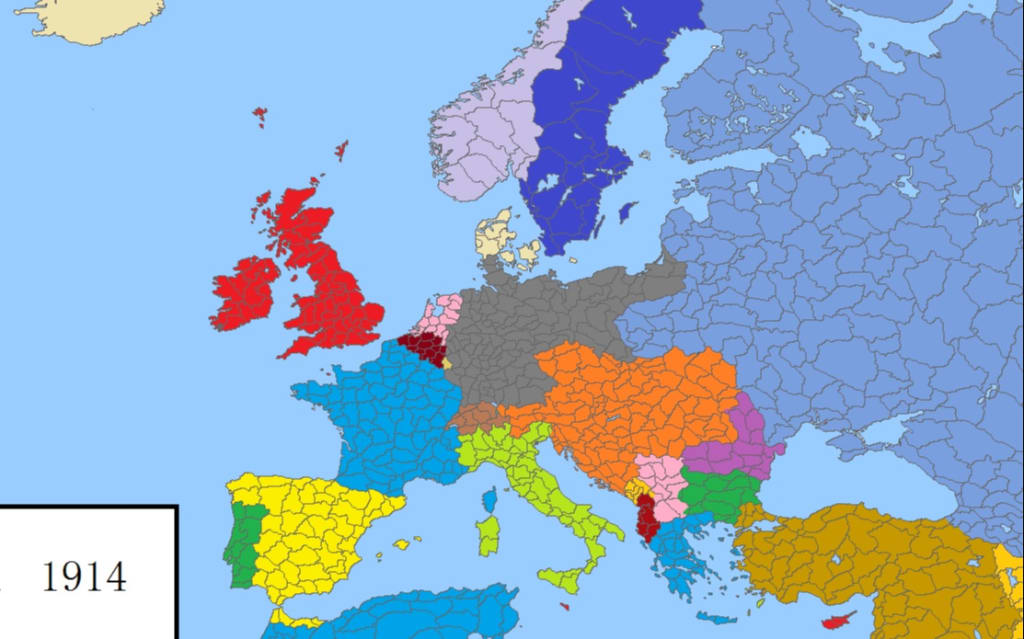
A friend once asked me how big the territory of Athens is. The answer can be found in the division of the geopolitical structure within Greece today. In the internal administrative division of Greece, the section where Athens is located is called "Attica Region" (enter "Attica" in Google Maps, and the range will be displayed). The narrow Attica peninsula can also point to this region alone. However, the "Attica Peninsula" we have divided from the geographical structure should include the entire peninsula structure area between Evia Island and the Peloponnese Peninsula. Athens, located in the southeast, is not the only powerful city-state on the peninsula.
Referring to the "Schematic Diagram of the Hippo War (480 BC)", we will find that the Attica peninsula, like the entire Greek peninsula, is covered by mountains. In addition to the narrow coastal plains between the mountains and the sea, there are two large low areas in the interior of the peninsula where the hills and plains are offset. One is from the Isthmus of Corinth in the west to the Marathon Plain in the east, including the city of Athens, and the southeastern corner of the peninsula; the other low area is in the central and western hinterland of the peninsula, and the Kisfiel River is the main river that traverses it. In today's internal administrative divisions of Greece, most of them belong to the state of Boeotia, except for the upper part of the Kisfer Valley.
The city-state that controlled the Boeotia region was Thebes, which later competed with Athens and Sparta. However, in this era of the prevalence of "rotten women" culture, when it comes to the name Thebes, many people may be more interested in the "Thebes Holy Army" composed of 150 pairs of "gay men". Of course, this army, which was formed in 378 BC, would definitely not be able to catch up with the Hippo War.
Friends who are interested in the Holy Army can Baidu by themselves. Let's get down to business and interpret the Hippo War. From the perspective of sphere of influence, we can think that the two main forces on the Attica Peninsula are Thebes and Athens. If the object of protection of the Greek coalition is only the Peloponnesian country to which Athens and Sparta belong, then the Boeotia region and its west can be abandoned.
In fact, the Greek coalition may indeed do so. Because when the Persians came back to ask for water and soil, Thebes was also one of the city-states that offered water and soil. But like the Cesars, the Thebes didn't really think about how they would stand in line. If Athens and Spartans were prepared to defend the entire Attica peninsula, they could also help; if they were kept out of the line, the Persians certainly would not have encountered in Boeotia. resistance.
In the end, after intense discussions, the Greek coalition with Athens and Sparta as the core decided to locate the defense line at the northwest corner of the Attica Peninsula, which is the famous "Hot Spring Pass". Given that they were also included in the scope of protection, the Thebes reluctantly joined the Greek coalition and provided 400 soldiers for the upcoming Battle of Thermal Pass. Why are the Thebans reluctant? We'll give the answer when we formally decipher the campaign.
Now the question we have to solve is why it is "Hot Spring Pass". This is because after passing through the Thessaly Basin, the main passage to the Attica peninsula needs to go along the edge of the northern mountains of Attica, go east for a distance, and then go straight into the Boeotia area through the valley, and finally arrive at Athens. . Today, the main road that crosses the Attica Peninsula and reaches Athens is still the same. The location of Wenquan Pass is on the original coastal route.
If Wenquan Pass is controlled by a narrow and long passage adjacent to mountains and seas, it is easy to understand that the Greek coalition forces chose to deploy here. This situation is the same as the establishment of Shanhaiguan. However, some friends have measured the distance on Google Maps. They think that the location of Wenquan Pass, the distance between the mountain and the ocean is 3 kilometers, and that it is impossible for the Spartans to arm the 3,000-meter line of defense with only 300 people. However, time has passed for more than 2,400 years after all. The mountain-sea passage where Wenquan Pass was located was not so wide. The passages before the mountains and coastal tidal flats can indeed be called tunnels. Of course, the story of defending against hundreds of thousands of Greek troops with 300 people is indeed too exaggerated. If so, no matter how well-developed the muscles of the Spartans are, they can't stand a few blows.
Then, how many troops are there in the Greek coalition forces guarding Wenquan Pass? Judging from the strength of the troops who had previously deployed the Tenby Valley, the Greek defenders should not be less than 10,000 at least. However, perhaps the Greek-style "democracy" is indeed more conducive to the fairness of the regime's power in times of peace, but in times of war, "democratic" discussions within the Greek coalition will obviously reduce the efficiency of their actions. Just like the decision to position Wenquan Pass as the first line of land defense, if it had been planned early, those 10,000 hoplites who had returned from the Tenby Valley would not have to ship back to the Isthmus of Corinth. Now, the Greeks need to regroup their troops from south to north, towards Wenquan Pass. Unfortunately, the Persians moved faster than the Greeks expected, and by the time the Persian army arrived at Thermopylae, the Greek coalition had only time to gather 6-7,000 men there.
The actual number of participants in the Battle of Wenquan Pass has actually been a matter of constant debate. 6-7,000, a relatively reliable figure (of which about 4,000 were from the city-states of the Peloponnese). However, there is no objection to the fact that the 300 elites led by the King of Sparta are the main force of the Greek coalition. For the Greeks, the most favorable terrain is the hot springs pass. From the topographic map, we can see that the mountain on which the hot springs pass is the main peak of the mountains on the northern edge of the entire Attica Peninsula (Kallidromo, 1399 meters above sea level). Technically, the possibility of the Persians climbing this peak is virtually non-existent. Of course, as we'll see later, the Persians didn't actually try to climb over it, but went around the back of the mountain.
The narrow passage between mountains and seas left no room for the Persian cavalry; the arrows of the Persians could not penetrate the heavy armor and shields of the Spartans. The only thing the Persians could do was to use hoplites to attack the Greek lines head-on. The problem is that, given the terrain of the tunnel, the fighting area between the two sides cannot be too wide. In other words, every time the Persians attacked, only a few dozen people could really be strangled by the two sides.
For the Greeks, this was undoubtedly an advantage, which enabled them to withstand more rounds of attacks with their stretched-out troops. However, the numerical superiority of the Persians was eventually revealed. The so-called "kill a thousand enemies, lose eight hundred". Although it was the most elite Spartan garrison among the Greeks who met the enemy head on, the Persians still had the money to spend with them even if they could inflict multiple kills on their opponents. The only point of desperately resisting is to buy time for the arrival of reinforcements.
As for the Persians, they had no idea at first that the resistance of the Greeks would be so stubborn. In view of the precedents of Thrace, Macedonia, and Thessaly, the Persians even observed the Greeks for a few days before the war (equivalent to a demonstration), waiting for the defenders to escape on their own. In fact, this would have really happened if there weren't 300 Spartans who would die. In addition to this kind of professional soldiers who have undergone strict military training since childhood (including the indoctrination of the thought of seeing death as death). How many people will give their lives for a battle that has no hope of victory at all? At least the Athenians shouldn't. The reason why they dared to fight with the Persians in the Battle of Marathon is because they calculated the strength of both sides, plus their understanding of the terrain, and felt that they had a 50% chance of winning before doing so. of.
However, although the Spartans showed more military spirit in this war, the dominant force that ultimately determined the direction of the war was Athens. Because for a peninsula-shaped structure like Greece, the biggest risk comes from the sea. Even if the hot springs pass is the only tunnel leading to the central and southern regions of Greece, even the Greeks have enough army to guard the hot springs pass, but please don't forget that the Persians also brought a powerful navy this time. They can completely detour from the sea and land to the back of Hot Springs Pass to directly attack Athens and the Peloponnese (or first outflank the defenders of Hot Springs Pass to open the land passage).
Being in the maritime civilization, the Greeks of course understand the importance of ocean control in defending Greece. As the Athenian with the strongest sea awareness in the entire Greek city-state, he began to expand his navy shortly after the battle of Marathon. For the Athenians, expanding the navy was a surefire way to attack and defend. If the Athenian navy can finally defeat the Persians at sea, then in addition to the Persians not being able to choose the landing site at will, the supply lines will be completely exposed to their own attack power. In this case, the scale of victory will be tilted to the Greek side; if not, the Greeks can also ship their citizens to overseas colonies.
After nearly ten years of preparation, the Athenians had expanded their navy to 180 warships before the war, while the other Greek warships participating in the war were roughly the same number. Coupled with the updated and technologically advanced Athenian warships, the Athenian Navy undoubtedly occupies a dominant position in the entire Greek combined fleet. However, compared with the Persian navy, this figure is stretched again. Because in this decade, the Persian Empire built as many as 1,200 warships in Phoenicia, Ionia and other Asian coastal areas. More importantly, the tonnage of these warships is generally larger than that of the Greek Navy. You know, even back in time to World War I, the tonnage of a warship is still a major factor in comparing naval strength. In the sea without the influence of "people's war", you can only compete for strength. The larger tonnage means that it can carry more weapons, equipment and personnel.
When the Greek army led by the Spartans began to march towards Thermopylae, the combined Greek fleet led by the Athenians also began to depart from the city-states and cross the waterway between the island of Evia and the Greek peninsula (the Gulf of Evia). ) to gather in the direction of Wenquanguan to prevent the Persian navy from outflanking the guards of Wenquanguan. However, the Greek navy did not place the blocking point on the side of the Hot Springs Pass, but continued to sail eastward to Cape Artemisia, the northeast corner of "Evia Island". This point was chosen because the Gulf of Evia is not the only sea route to the southern part of the Greek peninsula. It is entirely possible that the Persians would go south from the outside of Evia, bypass the Greek fleet in the Gulf of Evia, and land directly in Athens.
From a tactical point of view, there is absolutely no problem in choosing "Azumiyasi Cape" as the blocking point, just as the Hot Springs Pass is indeed the best pass for the Greek Army to deploy. However, all tactics require strong support. Without the support of strength, even the best plan cannot be successfully implemented. The big problem for the Greek fleet was that they were far inferior to the Persians in numbers and tonnage. It is very doubtful whether the Persian Navy can be defeated in a positive PK.
Fortunately, there are many sea gods in Greek mythology. In the first expedition organized by the Persians twelve years ago, these sea gods bless the Greeks once. The terrifying experience of the Persian navy encountering a storm under Mount Athos and the annihilation of the entire army even took Xerxes more than three years to dig a seemingly meaningless canal. If you are lucky, the Persians who are not familiar with the sea climate may be "baptized" by the storm again.
In general, the Mediterranean climate is very good. In some places, the sunshine can even reach more than 300 days a year. Such a sunny and sunny environment has also contributed to the marine civilization of the Aegean Sea and the entire Mediterranean region. However, this does not mean that calm seas are free from danger. A rare weather phenomenon that meteorologists call a "Mediterranean tropical cyclone" sometimes occurs when the Mediterranean meets August and September. The so-called "tropical cyclone" is what is called a "typhoon" in East Asia and a "hurricane" in Europe and the United States. Because the probability of occurrence is too small, meteorologists are still not sure whether this strong wind that occasionally blows in the Mediterranean in September is a typhoon and hurricane. But no matter what the wind is called, it's just a headache for meteorologists, as long as we know it's strong enough.
The first expedition of the Persians was destroyed by this "Mediterranean tropical cyclone". Speaking of which, if it wasn't for the Persians, who insisted on choosing summer expeditions every time, maybe it wouldn't be so unlucky. Of course, in general, Mediterranean summers are always pleasant. In addition, the toughest Spartans in the Greek city-state celebrated their sacred "Kania" every year in September, and if the Persians invaded at this point, they would have a better chance of victory.
However, as long as the rules are set by people, they can be changed. Just like this time when the Persians invaded again in August or September, the Spartans held a meeting and decided to change it (or else there would be no "Three Hundred Spartans"). ), after all, the existence of gods is also to bless his people. The problem is that although people can be flexible, the changes in the weather will not be transferred with people's will. The time point chosen by the Persians did not embarrass the Spartans, but it was another annoying "Mediterranean tropical cyclone" that they encountered.
The place where the Persian navy was baptized by the storm again was very close to Cape Artemisia, where the two sides were about to engage in battle. We can see on the map that the eastern edge of the Thessaly Basin is a peninsula covered by mountains and facing the island of Evia across the sea - the Magnesia Peninsula. The Persian navy needed to travel south along the edge of the Magnesian peninsula, then turn at "Cape Sepias" in the southeastern part of the peninsula and head west toward the Attica peninsula.
The Persian navy fleet was once again punished by the god of the sea when it docked at Cape Sepias. On the opposite side of the cape is a small island, and the sea is equivalent to a strait. It is not certain whether the cyclone encountered by the Persians was related to the structure of the strait. But in contrast to the previous storm and the upcoming storm, it was about the mountain-covered promontory. The suffering endured by the Persian navy was every time it turned along such a cape.
To be honest, the luck of the Persians was indeed extremely bad when they encountered such a small probability storm again and again. However, this is actually related to the shallow marine cultural accumulation of the Persian Empire. In fact, Xerxes was reminded before the expedition that the Persian navy was too numerous and the battleships were too large. Greece's gulf-protected, storm-proof ports could not accommodate this large fleet. However, under the dominance of continental thinking, the Persians lack the awe of the ocean. The ultimate reason for choosing the storm-prone promontory to temporarily moor overnight is from this (their original docking point should be the bay 12 nautical miles to the west). In fact, people with sailing experience, such as the Ionians in the fleet, should have doubts about this choice. However, since the Persians had chosen to dock, they could not object.
Before the storm, those with enough sailing experience
About the Creator
Keep reading
More stories from guanjianwenti001 and writers in Earth and other communities.
European Series - Macedonia's Choice in the "Hippo War"
After the Battle of Marathon, Athens, which successfully repelled the Persian army, undoubtedly injected a shot of stimulant into the entire Greek region, and its prestige has naturally been greatly improved. Speaking of which, the Spartans had a chance to share the victory. Because before the war, the Athenians had turned to this old enemy for help. Seeing that they had also humiliated the Persians, the Spartans agreed to Athens' request (with 2000 reinforcements). However, the Spartans will celebrate their most important festival "Kania" every year in September. During the nine days of celebrating the festival, in order to show respect for the gods, no war can be waged. And the Persian attack, "just" in September.
By guanjianwenti0012 years ago in Earth
9 thrilling things about the Amazon forest
Exciting and chilling revelations about the Amazon rainforest. What makes the Amazon the world's largest forest? Uncovering the truth about the rumored city of giants in the Amazon. What creatures reside here, including the monsters? The most dangerous and hair-raising animal in this mysterious forest. Interested in exploring the enigmatic Amazon rainforest? Share your thoughts below. Known as the green lung of humanity, the Amazon is a vast forest in South America, shaped by the Amazon River flowing through nine countries, holding a hidden trove of treasures. Fascinating and spine-chilling wonders that challenge scientists to investigate from the heart of the Amazon rainforest. What shocking discoveries await today? First off, the Amazon spans 17 times the size of Vietnam, a staggering comparison. When it comes to the world's largest forest, the Amazon unquestionably claims the title. Mainly situated in Brazilian territory, the Amazon tropical forest covers 60 percent of South America's total land area. On the map, the vastness of the Amazon is evident, stretching around 5,000 meters. The Amazon forest's 5 million square kilometers equal half the combined area of the United States, including Alaska and Hawaii, almost matching the 7.7 million square kilometers of Australia. Compared to Vietnam's 331,690 square kilometers, the Amazon surpasses it by nearly 17 times, a significant statistic. Experts state that this forest produces twenty percent of Earth's oxygen, justifying its nickname as the green lung of humanity. So, what mysteries are hidden within the Amazon rainforest? Let's explore them promptly. Furthermore, the creatures within are not just massive; they are diverse and perplexing to scientists. The Amazon is home to 1,294 bird species, 3,000 freshwater fish species, 427 mammal species, 428 amphibian species, 380 reptile species, and an astonishing 2.5 million insect types, some of which are formidable creatures. Leading the pack is the world's largest python, the reticulated anaconda. Living in swamps and water bodies, these anacondas can reach lengths of 5 to 7 meters and weigh up to 250kg, displaying impressive strength. Additionally, the black caiman, a sizable crocodilian, stands out as a predator with a bite force comparable to a hydraulic press, instilling fear. For the cautious, the giant arapaima, or "pirarucu," can grow up to 2.7 meters in length and weigh 90kg, armed with tooth-lined tongues. Notably, the bull shark, a versatile predator, navigates freshwater and estuarine environments, with individuals reaching 3.3 meters and weighing 312kg, equipped with rows of sharp teeth and a formidable bite force of up to 500kg. Bull sharks are among the most dangerous aquatic predators globally. Also included is the giant otter, capable of challenging crocodiles for dominance, recognized as one of the Amazon River's top carnivores, earning the title "river wolf." These are the formidable inhabitants within the Amazon's lush expanse. In addition to these formidable predators, the Amazon is home to numerous venomous snakes, including the bushmaster, measuring 2 to 3 meters long and up to 9kg in weight, and the bushmaster snake, with its cryptic brown color and tree-dwelling skills, able to swiftly paralyze its prey. Notable is the coral snake, whose venom causes respiratory failure and convulsions within hours of being bitten. The electric eel, a bioelectric wonder, produces voltages of 600 to 900 volts, potent enough to defeat crocodiles and unsuspecting intruders. Also, the golden dart frog, with its bright yellow colors and powerful neurotoxins, matches the lethality of its aquatic counterpart, the electric eel. Let's not forget the bullet ant, famous for its painful sting, described as hot coals pressed against the skin, causing agony for up to 24 hours and potentially leading to fatal anaphylactic reactions if untreated. Also, the Amazon shelters dangerous animals like the Brazilian wandering spider, capable of causing respiratory distress and eventual death within a short timeframe. Be cautious around the riverbanks to avoid encounters with the notorious candiru fish, known for entering the urethra and causing severe injuries. Lastly, the Anopheles mosquito, a tiny yet mighty carrier, transmits debilitating malaria, posing a significant health risk within the Amazon. Navigating the Amazon demands mental strength. For those who have not yet embarked on this journey, the Amazon boasts a plethora of unique and fascinating plant species, with around 40,000 plant varieties, including the intriguing walking palm.
By Pham thi hoa2 days ago in Earth
Climate Change
Lila perched on her bed's edge, her room bathed in the gentle amber of sunrise. But a tempest churned within her. At just 17, Lila was already a seasoned warrior in the climate crusade, pouring three tireless years into safeguarding our Earth. Yet the planet's cries seemed to escalate, slipping through her fingers like sand.
By Bok Victor Nasha day ago in Earth


Comments
There are no comments for this story
Be the first to respond and start the conversation.